El Salvador, the smallest and most densely populated country in Central America, is known for its diverse and varied terrain. The country is located on the Pacific coast of Central America and is bordered by Guatemala to the west, Honduras to the north and east, and the Pacific Ocean to the south. El Salvador’s terrain is characterized by its mountain ranges, valleys, lowlands, and coastal plains, which all contribute to the country’s unique topography. The terrain and topography of El Salvador have played a significant role in shaping the country’s climate, human settlements, and agricultural practices.
The diverse terrain of El Salvador is a result of its location along the Pacific Ring of Fire, a region known for its volcanic activity and tectonic plate movements. The country is home to over 20 volcanoes, some of which are still active, and these volcanic formations have greatly influenced the country’s topography. The varied terrain of El Salvador has also contributed to the country’s rich biodiversity, with diverse ecosystems ranging from cloud forests in the mountains to mangrove swamps along the coast. Overall, El Salvador’s terrain and topography are integral to the country’s natural landscape and have a significant impact on its climate, human settlements, and conservation efforts.
Summary
- El Salvador’s terrain is diverse, with mountain ranges, valleys, lowlands, and coastal plains.
- The mountain ranges, such as the Sierra Madre, dominate the western part of the country and influence its climate.
- The valleys and lowlands, like the Lempa River Valley, are important for agriculture and human settlements.
- The coastal plains, including the Pacific Coastal Plain, are vital for fishing and tourism.
- The varied terrain of El Salvador impacts its climate, with the highlands being cooler and the lowlands being warmer, influencing agriculture and human settlements.
The Mountain Ranges of El Salvador
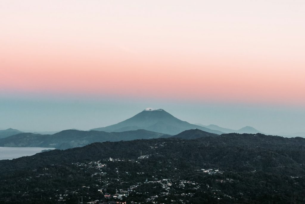
El Salvador is home to several mountain ranges that traverse the country and contribute to its diverse topography. The most prominent mountain range in El Salvador is the Cordillera de Apaneca, which runs along the western part of the country. This mountain range is characterized by its rugged terrain, steep slopes, and lush vegetation, making it a popular destination for hikers and nature enthusiasts. The Cordillera de Apaneca is also home to several volcanoes, including the Santa Ana Volcano, which is the highest volcano in El Salvador and offers stunning views of the surrounding landscape.
In addition to the Cordillera de Apaneca, El Salvador is also home to the Cordillera de Guazapa in the north and the Cordillera de Cacahuatique in the east. These mountain ranges are known for their diverse flora and fauna, including a variety of endemic species that are unique to the region. The mountainous terrain of El Salvador has also played a significant role in shaping the country’s climate, as it influences weather patterns and precipitation levels. Overall, the mountain ranges of El Salvador are an integral part of the country’s topography and contribute to its rich natural landscape.
The Valleys and Lowlands of El Salvador
In addition to its mountain ranges, El Salvador is also home to several valleys and lowlands that contribute to its varied topography. The most prominent valley in El Salvador is the Lempa River Valley, which is located in the central part of the country. This valley is known for its fertile soil and is a major agricultural region, producing a variety of crops such as coffee, sugar cane, and corn. The Lempa River Valley is also home to several important archaeological sites, including the ancient city of Cihuatan, which was once a thriving pre-Columbian settlement.
In addition to the Lempa River Valley, El Salvador is also home to several lowland regions along its coastline. These coastal lowlands are characterized by their sandy beaches, mangrove swamps, and estuaries, which are important habitats for a variety of wildlife. The lowland regions of El Salvador also play a significant role in the country’s economy, as they are important for tourism, fishing, and salt production. Overall, the valleys and lowlands of El Salvador are an integral part of the country’s topography and contribute to its rich natural landscape.
The Coastal Plains of El Salvador
El Salvador is home to a narrow coastal plain that runs along its Pacific coastline, which contributes to its diverse topography. The coastal plains of El Salvador are characterized by their sandy beaches, mangrove swamps, and estuaries, which are important habitats for a variety of wildlife. These coastal plains are also important for tourism, as they are popular destinations for beachgoers and water sports enthusiasts. In addition to their recreational value, the coastal plains of El Salvador also play a significant role in the country’s economy, as they are important for fishing and salt production.
The coastal plains of El Salvador are also important for agriculture, particularly for the cultivation of crops such as rice and cotton. The fertile soil and tropical climate of the coastal plains make them ideal for agriculture, and they are an important source of food and income for many people in the region. Overall, the coastal plains of El Salvador are an integral part of the country’s topography and contribute to its rich natural landscape.
Impact of Terrain and Topography on El Salvador’s Climate
The varied terrain and topography of El Salvador have a significant impact on the country’s climate, influencing weather patterns and precipitation levels. The mountain ranges in El Salvador play a crucial role in shaping the country’s climate by affecting temperature and rainfall. As air masses move across the mountains, they are forced to rise, leading to cooling temperatures and increased precipitation on the windward side of the mountains. This phenomenon results in wetter conditions on the western side of the country where the Cordillera de Apaneca is located, while the eastern side experiences drier conditions due to the rain shadow effect.
The coastal plains and lowland regions of El Salvador also contribute to its climate by influencing humidity levels and temperature variations. The proximity to the Pacific Ocean moderates temperatures along the coast, leading to more stable and milder climates compared to inland areas. Additionally, the coastal plains contribute to higher humidity levels due to their proximity to bodies of water, which can lead to increased rainfall in these regions. Overall, the varied terrain and topography of El Salvador play a crucial role in shaping its climate, leading to diverse weather patterns across different regions of the country.
Human Settlements and Agriculture in El Salvador’s Varied Terrain
The diverse terrain and topography of El Salvador have played a significant role in shaping human settlements and agricultural practices in the country. The mountainous regions of El Salvador have historically been home to indigenous communities who have adapted to living in rugged terrain by practicing terrace farming on steep slopes. These communities have cultivated crops such as maize, beans, and coffee using traditional agricultural techniques that take advantage of the natural landscape. In addition to agriculture, these mountainous regions have also been important for mining activities due to their rich mineral deposits.
The valleys and lowlands of El Salvador have also been important for human settlements and agriculture due to their fertile soil and access to water sources. The Lempa River Valley, in particular, has been a major agricultural region since pre-Columbian times, with communities cultivating crops such as maize, sugar cane, and cotton. The coastal plains have also been important for human settlements and agriculture due to their proximity to bodies of water and their suitability for growing crops such as rice and cotton. Overall, the varied terrain and topography of El Salvador have influenced human settlements and agricultural practices in different regions of the country.
Conservation Efforts in El Salvador’s Diverse Landscape
The diverse landscape of El Salvador has led to conservation efforts aimed at protecting its natural resources and biodiversity. The mountain ranges in El Salvador are home to several protected areas such as national parks and reserves that aim to preserve unique ecosystems and endemic species. For example, Cerro Verde National Park is located in the Cordillera de Apaneca and is known for its cloud forests and diverse wildlife, including rare bird species such as quetzals and toucans. These protected areas play a crucial role in conserving biodiversity and providing habitat for endangered species.
In addition to mountainous regions, efforts have also been made to conserve coastal plains and lowland areas in El Salvador. Mangrove swamps along the coast are important ecosystems that provide habitat for a variety of wildlife and protect against coastal erosion. Conservation efforts have focused on preserving these valuable habitats through initiatives such as reforestation projects and sustainable management practices. Overall, conservation efforts in El Salvador aim to protect its diverse landscape by preserving natural habitats, promoting sustainable land use practices, and raising awareness about environmental conservation.
In conclusion, El Salvador’s terrain and topography are integral to its natural landscape and have a significant impact on its climate, human settlements, agriculture, and conservation efforts. The diverse mountain ranges, valleys, lowlands, and coastal plains contribute to a rich tapestry of ecosystems that support a wide variety of flora and fauna. Conservation efforts aimed at protecting these diverse landscapes play a crucial role in preserving biodiversity and ensuring sustainable land use practices for future generations. Overall, El Salvador’s terrain and topography are an essential part of its identity as a country with a rich natural heritage shaped by its unique geographical features.
FAQs
What is the terrain and topography of El Salvador like?
El Salvador’s terrain is characterized by a mix of mountains, valleys, and plains. The country is part of the Central American volcanic chain, resulting in a rugged and varied landscape.
What are the major mountain ranges in El Salvador?
The major mountain ranges in El Salvador include the Sierra Madre, which runs along the northern border with Honduras, and the Apaneca-Ilamatepec range in the west of the country.
Are there any significant valleys in El Salvador?
Yes, El Salvador is home to several significant valleys, including the Lempa River Valley, which is the country’s most important agricultural region, and the Jiboa Valley, known for its fertile soil and agricultural production.
What are the main plains in El Salvador?
The most notable plains in El Salvador are located along the coastal areas, particularly in the central and eastern regions of the country. These plains are important for agriculture and are home to a significant portion of the population.