World Geography
Geography is the study of the Earth’s landscapes, environments, and the relationships between people and their surroundings. It encompasses both the physical aspects of the Earth, such as its landforms, bodies of water, and climate, as well as the human aspects, including population distribution, cultures, and economies. World geography is a broad field that seeks to understand the complexities of our planet and how humans interact with it. By studying world geography, we can gain a deeper appreciation for the diversity of our planet and the interconnectedness of its various regions.
Geography is a multidisciplinary field that draws on elements of physical science, social science, and humanities. It involves the use of maps, spatial analysis, and geographic information systems (GIS) to understand the Earth’s surface and the processes that shape it. World geography also encompasses the study of human geography, which examines the ways in which people and their activities are distributed across the Earth. By understanding world geography, we can better appreciate the environmental, cultural, and economic challenges facing different regions of the world. This knowledge is crucial for addressing global issues such as climate change, resource management, and international development.
The Five Oceans and Seven Continents
The Earth’s surface is divided into five major oceans: the Pacific, Atlantic, Indian, Southern (or Antarctic), and Arctic Oceans. These vast bodies of water play a crucial role in regulating the Earth’s climate and supporting diverse marine ecosystems. The oceans also serve as important transportation routes and a source of food and other natural resources for human societies around the world.
In addition to the oceans, the Earth’s landmasses are divided into seven continents: Africa, Antarctica, Asia, Europe, North America, Australia (or Oceania), and South America. Each continent has its own unique physical and cultural characteristics, shaped by millions of years of geological processes and human history. From the deserts of Africa to the rainforests of South America, the continents offer a rich tapestry of landscapes and environments for exploration and study.
Major Mountain Ranges and Deserts
The Earth’s surface is also marked by major mountain ranges and deserts that have shaped the planet’s physical and cultural landscapes. The Himalayas, for example, are the highest mountain range in the world and are home to diverse ecosystems and cultures in countries such as India, Nepal, and Bhutan. The Andes in South America, the Rockies in North America, and the Alps in Europe are other prominent mountain ranges that have influenced human settlement patterns and economic activities.
Deserts cover about one-third of the Earth’s land surface and are characterized by low precipitation and extreme temperatures. The Sahara Desert in Africa is the largest hot desert in the world, while the Gobi Desert in Asia is one of the largest cold deserts. Deserts are not only home to unique flora and fauna but have also been important trade routes and cultural crossroads throughout history.
Climate Zones and Biomes
The Earth’s climate is influenced by a variety of factors, including latitude, altitude, ocean currents, and prevailing winds. As a result, the planet is divided into different climate zones, each with its own characteristic weather patterns and ecosystems. The equator, for example, experiences a tropical climate with high temperatures and heavy rainfall, while the polar regions have a cold and dry climate.
These climate zones give rise to different biomes, or large ecological areas characterized by distinct plant and animal communities. The tropical rainforest biome, found near the equator, is home to a diverse array of species and is vital for regulating the Earth’s climate. The grasslands biome, found in regions such as the African savannah and North American prairies, supports grazing animals and has been important for human agriculture throughout history.
Human Geography and Population Distribution
Human geography examines the ways in which people and their activities are distributed across the Earth’s surface. It encompasses topics such as population growth, migration patterns, urbanization, and cultural diversity. Understanding human geography is crucial for addressing global challenges such as poverty, inequality, and environmental degradation.
Population distribution is uneven across the world, with some regions experiencing rapid population growth while others are declining. The majority of the world’s population lives in Asia, particularly in countries such as China and India. Urban areas are also growing rapidly, with more than half of the world’s population now living in cities. This trend has significant implications for infrastructure development, resource management, and social inequality.
Historical and Cultural Geography
Historical geography examines how human activities have shaped the Earth’s landscapes over time. It explores topics such as colonialism, trade routes, and the rise and fall of empires. Cultural geography focuses on how human cultures have developed in different regions of the world and how they interact with their environments.
The Silk Road, for example, was an ancient trade route that connected China with Europe and facilitated the exchange of goods, ideas, and technologies across Eurasia. This historical trade route had a profound impact on the development of cultures and economies along its path. Similarly, cultural geographers study how different societies have adapted to their environments through practices such as agriculture, architecture, and religious beliefs.
The Importance of Geographic Knowledge
Geographic knowledge is crucial for addressing global challenges such as climate change, resource management, and international development. By understanding world geography, we can better appreciate the environmental, cultural, and economic challenges facing different regions of the world. This knowledge is crucial for addressing global issues such as climate change, resource management, and international development.
Geographic knowledge also helps us to understand our interconnectedness with other regions of the world. By studying world geography, we can gain a deeper appreciation for the diversity of our planet and the interconnectedness of its various regions. This understanding can foster a sense of global citizenship and empathy for people from different cultures and backgrounds.
In conclusion, world geography is a complex and multifaceted field that encompasses both physical and human aspects of the Earth’s landscapes. By studying world geography, we can gain a deeper appreciation for the diversity of our planet and the interconnectedness of its various regions. This knowledge is crucial for addressing global challenges such as climate change, resource management, and international development. It also helps us to understand our interconnectedness with other regions of the world and fosters a sense of global citizenship.
FAQs
What is world geography?
World geography is the study of the Earth’s landscapes, environments, and the relationships between people and their environments. It encompasses the physical features of the Earth, as well as the human activity that takes place on it.
Why is world geography important?
World geography is important because it helps us understand the world around us. It provides insights into the physical and human processes that shape our planet, and helps us make informed decisions about how to interact with our environment.
What are the main branches of world geography?
The main branches of world geography include physical geography, which focuses on the Earth’s natural features and processes, and human geography, which examines the relationships between people and their environments.
How does world geography impact our daily lives?
World geography impacts our daily lives in numerous ways, from influencing the weather and climate we experience, to shaping the availability of natural resources and influencing the distribution of populations and cultures around the world.
What are some key concepts in world geography?
Key concepts in world geography include location, place, human-environment interaction, movement, and region. These concepts help geographers understand and interpret the world around them.

Cultural or Historical Sites of Armenia: Important Cultural Landmarks or Historical Sites In Armenia
Armenia, a small country located in the South Caucasus region of Eurasia, is known for its rich history and cultural heritage. With a history dating back thousands of years, Armenia has been home to various civilizations and empires, each leaving their mark on the land. From ancient cities to medieval monasteries, Armenia is a treasure trove of archaeological sites and monuments that offer a glimpse into its fascinating past. Exploring these ancient sites is not only a way to learn about Armenia’s history but also to appreciate its cultural heritage and the resilience of its people. Summary Ani offers a glimpse into Armenia’s medieval past with its well-preserved ruins. Geghard Monastery showcases the country’s unique blend of spirituality and architecture. The Temple of Garni is a must-visit for those interested in Armenia’s pagan history. The Armenian Genocide Memorial is a somber reminder of the country’s tragic past. The Matenadaran is a treasure trove of Armenian literature and intellectual heritage. The Ancient City of Ani: A Window into Armenia’s Medieval Past One of the most significant ancient sites in Armenia is the city of Ani. Located on the border with Turkey, Ani was once the capital of the Bagratid Kingdom of Armenia in the 10th and 11th centuries. Known as the “City of 1001 Churches,” Ani was a thriving center of trade and culture during its heyday. Today, it stands as a testament to Armenia’s medieval past. The architecture of Ani is a blend of Armenian, Byzantine, and Islamic influences. The city is home to numerous churches, palaces, and fortifications, each showcasing intricate stone carvings and architectural details. Some of...

Armenia’s Mining and Mineral Riches: A Deep Dive into Natural Resources of Armenia
Armenia’s Mining and Mineral Riches: A Deep Dive into Natural Resources of Armenia Armenia is rich in mineral wealth, boasting significant deposits of copper, molybdenum, gold, and other metals. As a landlocked nation with a mountainous terrain, Armenia has long relied on its underground assets to power its economy. This article explores the natural resources of Armenia, delves into the country’s mining and mineral sector, and examines how responsible mining can shape the nation’s future. If you’re interested in Armenia’s economic prospects, its mineral-rich soil, and how it navigates environmental concerns while boosting exports, this is a must-read. Outline What Are the Major Mineral Resources in Armenia? How Does the Mining Industry Impact Armenia’s Economy? Where Are the Largest Mines Located in Armenia? What Role Do Copper and Molybdenum Play in the Armenian Mining Sector? How Does Armenia Promote Responsible Mining? What Are the Leading Mining Companies in Armenia? What Minerals Are Exported from Armenia? How Does the Armenian Government Regulate Mining? What Are the Environmental Effects of Mining in Armenia? What Is the Future of Armenia’s Mining Industry by 2035? What Are the Major Mineral Resources in Armenia? Armenia is rich in natural resources, especially mineral resources such as copper, molybdenum, gold, and other metals. These resources are registered in the state inventory of mineral resources and play a vital role in the economic framework of the republic of Armenia. The country has a diverse array of mines including base metal mines, gold and gold-polymetallic mines, and 2 iron ore mines. The abundance of copper and molybdenum concentrates in Armenia is a testament to its...

Population Density of Armenia
Population density refers to the number of people living in a specific area, usually measured per square kilometer. It is an important indicator that helps us understand how people are distributed across a country or region. Studying population density is crucial for policymakers and researchers as it provides insights into various social, economic, and environmental factors. In the case of Armenia, understanding population density is particularly significant due to the country’s unique geographical and historical context. Armenia is a landlocked country located in the South Caucasus region of Eurasia. It has a rich history and a diverse population, making it an interesting case study for examining population density trends and their implications. Summary Armenia has a population density of 104 people per square kilometer. The population density of Armenia has fluctuated throughout history due to various factors such as wars and migration. Factors affecting population density in Armenia include economic opportunities, natural resources, and political stability. The majority of Armenia’s population is concentrated in the central and northern regions of the country. Urbanization has led to higher population density in cities, while rural areas have experienced a decline in population. Historical Overview of Armenia’s Population Density Armenia has experienced significant changes in its population density over time. In ancient times, the region was densely populated, with numerous settlements and cities. However, due to various historical events such as invasions, wars, and forced migrations, the population of Armenia declined significantly. During the Soviet era, Armenia experienced a period of rapid population growth. The government implemented policies to encourage population growth, resulting in increased birth rates and decreased mortality rates. This...

Political Boundaries of Argentina: Provinces, Districts, or Historical Boundaries.
Political boundaries are the lines that separate different political entities, such as countries, states, or provinces. They define the jurisdictional authority of a particular government and determine the rights and responsibilities of its citizens. Understanding political boundaries is crucial for effective governance and administration, as well as for maintaining peace and order within a country. In Argentina, a vast and diverse country located in South America, political boundaries play a significant role in shaping its political, economic, and social landscape. With 23 provinces and one autonomous city, Argentina’s political boundaries define the distribution of power and resources across the country. It is essential to have a comprehensive understanding of these boundaries to grasp the complexities of Argentine politics and society. Summary Argentina is divided into 23 provinces and one autonomous city, Buenos Aires. Buenos Aires is the capital district and holds significant political power in the country. Argentina’s historical boundaries have evolved from the Viceroyalty to the Republic. The federal system of government in Argentina has its own powers and limitations. Municipalities play a crucial role in local governance and autonomy in Argentine politics. The 23 Provinces of Argentina: A Brief Overview Argentina is divided into 23 provinces, each with its own distinct characteristics and contributions to the country’s overall development. These provinces are: 1. Buenos Aires2. Catamarca3. Chaco4. Chubut5. Córdoba6. Corrientes7. Entre Ríos8. Formosa9. Jujuy10. La Pampa11. La Rioja12. Mendoza13. Misiones14. Neuquén15. Río Negro16. Salta17. San Juan18. San Luis19. Santa Cruz20. Santa Fe21. Santiago del Estero22. Tierra del Fuego, Antártida e Islas del Atlántico Sur23. Tucumán Each province has its own unique geography, culture, and economic activities that...
Climate Zones of Argentina: Different climate regions Of Argentina
Argentina is a country known for its vast and diverse landscapes, ranging from the towering Andes mountains to the expansive Pampas plains. This diversity is reflected in the country’s climate zones, which vary greatly from region to region. Argentina is located in the southern hemisphere, which means that its seasons are opposite to those in the northern hemisphere. The country’s geography and size contribute to its climate diversity, with influences from the Atlantic Ocean, the Andes mountains, and the surrounding landmasses. Summary Argentina has a diverse range of climate zones, each with unique characteristics and weather patterns. The Humid Pampas Region is known for its fertile soil and agricultural production, but also experiences frequent flooding. The Dry Andes Region is a high-altitude desert with extreme temperature fluctuations and limited vegetation. The Subtropical Region is hot and humid, with a rainy season and a dry season. The Temperate Forest Region has a mild climate and is home to diverse flora and fauna, including the iconic Argentinean national tree, the ombú. The Patagonian Desert Region is a cold and windy desert with sparse vegetation and unique geological formations. The Mediterranean Region has a mild, rainy winter and a hot, dry summer, making it ideal for wine production. Climate change is affecting Argentina’s climate zones, with increased temperatures and changes in precipitation patterns. Argentina’s climate zones offer a range of tourism opportunities, from skiing in the Andes to exploring the wildlife in the subtropical rainforest. Appreciating the diversity of Argentina’s climate zones is key to understanding the country’s natural beauty and cultural heritage. The Humid Pampas Region The Humid Pampas region is...

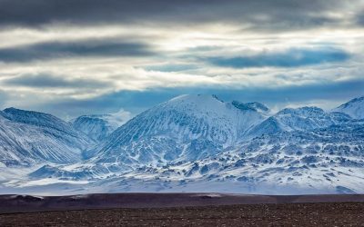
Terrain and Topography of Argentina: mountains, valleys, and plains.
Introduction Argentina is a country known for its diverse and stunning landscapes. From the majestic Andes Mountains to the vast plains of the Pampas, Argentina’s terrain offers a wide range of geographical features that contribute to its unique beauty and cultural heritage. Understanding the country’s geography is essential for appreciating its natural wonders and the importance they hold for Argentina’s economy, culture, and history. The Andes Mountains: A Majestic Range The Andes Mountains are a prominent feature of Argentina’s geography. Stretching along the western border of the country, this majestic range is one of the longest mountain ranges in the world. The highest peaks in Argentina, such as Aconcagua, reach heights of over 6,000 meters, making them some of the tallest mountains in the Americas. The Andes Mountains hold great significance for Argentina’s economy and culture. The region is rich in mineral resources, including copper, gold, and silver, which have played a crucial role in the country’s economic development. Additionally, the Andes are home to several indigenous communities that have preserved their traditional way of life and cultural practices for centuries. The Pampas: Vast Plains of Argentina The Pampas is a vast region of flat plains that covers a significant portion of central Argentina. This fertile land is known for its agricultural importance, as it provides ideal conditions for growing crops such as wheat, corn, and soybeans. The Pampas is often referred to as the “breadbasket” of Argentina due to its role in supplying food for the country and exporting agricultural products worldwide. Aside from its agricultural significance, the Pampas also boasts stunning natural beauty and diverse wildlife. The...

Population Density of Argentina
Population density refers to the number of people living in a specific area, usually measured per square kilometer. It is an important indicator of how crowded or sparsely populated an area is. Population density matters because it can have significant implications for various aspects of a country’s development, including infrastructure, resources, and social services. Argentina, the eighth-largest country in the world, has a population density of approximately 16 people per square kilometer. This makes it one of the least densely populated countries in the world. However, despite its low overall population density, Argentina has significant regional variations in population distribution. Understanding these variations and their underlying factors is crucial for understanding Argentina’s social and economic landscape. Summary Argentina has a population density of 16 people per square kilometer. Population density in Argentina has been increasing since the 19th century. Buenos Aires has the highest population density in Argentina, while Patagonia has the lowest. Urbanization and immigration are major factors contributing to high population density in urban areas. High population density areas in Argentina face challenges such as housing shortages and environmental degradation. Historical Overview of Population Density in Argentina Argentina’s population has experienced significant growth over time. In the early 19th century, the country had a relatively small population, with most people concentrated in urban areas such as Buenos Aires. However, with the expansion of agriculture and the influx of immigrants in the late 19th and early 20th centuries, Argentina’s population began to grow rapidly. The period between 1869 and 1914 is known as the “Golden Age” of immigration in Argentina. During this time, millions of immigrants from Europe,...
Natural Resources of Argentina: Where Natural Resources are located In Argentina
Argentina’s Natural Resources and Mining Industry: A Hidden Powerhouse of South America Argentina, a nation better known for tango, wine, and football, is increasingly making headlines in the world of mineral resources and mining. Blessed with vast untapped natural resources, Argentina is positioning itself as a global leader in lithium, copper, petroleum, and more. This article offers an in-depth exploration of Argentina’s mining industry, the role of the World Bank, and the impact of foreign investment. Whether you’re a curious reader, investor, or policy watcher, this article is worth your time because it deciphers how Argentina’s mines could fuel the future of the green economy. Article Outline Why Are Argentina’s Natural Resources So Important? What Is the Current State of Mining in Argentina? How Has the World Bank Supported Argentina’s Mining Growth? What Role Does Lithium Play in Argentina’s Future? Is Argentina Rich in Other Mineral Resources? What Is the Impact of Foreign Investment in Mining? How Do Mines Influence Argentina’s GDP and Exports? What Challenges Face the Mining Industry in Argentina? How Are Sustainability and Transparency Addressed in Argentina’s Mining Sector? What Does the Future Hold for Argentina’s Natural Resources? Why Are Argentina’s Natural Resources So Important? Argentina is one of the most resource-rich countries in Latin America, boasting a wealth of mineral resources and energy reserves. From natural gas to petroleum and lithium, Argentina is uniquely positioned to support both regional and global industries, particularly those pivoting to renewable energy and sustainable technology. The World Bank has classified Argentina among the Latin American countries with great potential for economic transformation via natural resources. Notably,...

Cultural or Historical Sites of Argentina: Important Cultural Landmarks or Historical Sites In Argentina
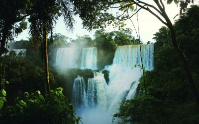
Argentina is a country known for its rich cultural heritage and natural wonders. From the vibrant streets of Buenos Aires to the breathtaking landscapes of Patagonia, Argentina offers a diverse range of experiences for travellers. In this article, we will explore some of the most iconic and enchanting destinations in Argentina, from the historic quarter of Buenos Aires to the mystical ruins of Tiwanaku. Whether you are a history buff, a nature lover, or simply seeking adventure, Argentina has something to offer for everyone. Summary Buenos Aires’ historic quarter offers a glimpse into Argentina’s past Teatro Colón is a must-visit cultural gem in Buenos Aires Iguazu Falls is a magnificent natural wonder of Argentina Bariloche is an enchanting haven for culture and history buffs Tiwanaku’s ruins provide a mystical glimpse into Argentina’s pre-Columbian past The Historic Quarter of Buenos Aires: A Journey Through Argentina’s Past The historic quarter of Buenos Aires is a must-visit destination for anyone interested in Argentina’s history. This area is home to some of the country’s most important landmarks and monuments, including Plaza de Mayo and Casa Rosada. Plaza de Mayo is the main square in Buenos Aires and has been the site of many significant events in Argentina’s history, including the May Revolution in 1810. Casa Rosada, the presidential palace, is located on one side of Plaza de Mayo and is an iconic symbol of Argentina’s political history. The Iconic Teatro Colón: A Cultural Gem of Buenos Aires The Teatro Colón is one of the most prestigious opera houses in the world and a cultural gem of Buenos Aires. Built in 1908, the theater...

Political Boundaries of Antigua and Barbuda: Provinces, Districts, or Historical Boundaries.
Antigua and Barbuda, located in the eastern Caribbean, is a small island nation with a rich history and vibrant culture. Understanding the political boundaries of this country is crucial for effective governance and decision-making. Political boundaries define the territories and jurisdictions within which governments operate, and they play a significant role in shaping the social, economic, and political landscape of a nation. Summary Antigua and Barbuda is a sovereign nation consisting of two major islands and several smaller ones. The country’s political boundaries have evolved over time due to colonization and independence movements. Provinces play a significant role in Antigua and Barbuda’s political system, with each having its own government and leader. The country is divided into six districts, each with its own unique characteristics and challenges. Political boundaries have a significant impact on Antigua and Barbuda’s society, including access to resources and representation in government. Historical Boundaries of Antigua and Barbuda The political boundaries of Antigua and Barbuda have evolved over time due to various historical factors. The islands were originally inhabited by the indigenous Arawak and Carib peoples before being colonized by the Spanish in the late 15th century. The British later established control over the islands in the 17th century, and they remained under British rule until gaining independence in 1981. During the colonial period, Antigua and Barbuda were part of the British West Indies Federation, which included several other Caribbean territories. The boundaries of these territories were often redrawn to suit the needs of the colonial powers, resulting in changes to Antigua and Barbuda’s political boundaries. The Role of Provinces in Antigua and Barbuda’s Political...
Natural Resources of Antigua and Barbuda: Where Natural Resources are located In Antigua and Barbuda
Antigua and Barbuda, a small island nation located in the Caribbean, is blessed with a variety of natural resources that contribute significantly to its economy and the livelihoods of its people. These resources include minerals, agricultural land, forests, marine resources, and energy sources. The abundance of these resources has played a crucial role in shaping the country’s history and development. Natural resources are essential for the economic growth and development of any nation. In the case of Antigua and Barbuda, these resources provide employment opportunities, contribute to the country’s GDP, and support various industries such as agriculture, tourism, and manufacturing. They also play a vital role in ensuring food security and providing raw materials for industries. Summary Antigua and Barbuda is a small island nation in the Caribbean with a variety of natural resources. The geography of Antigua and Barbuda includes coral reefs, beaches, and hilly terrain. Natural resources in Antigua and Barbuda are located in various parts of the country, including the coast and interior. Mineral resources in Antigua and Barbuda include limestone, clay, and sand. Agricultural resources in Antigua and Barbuda include crops such as sugarcane, bananas, and vegetables. Overview of the Geography of Antigua and Barbuda Antigua and Barbuda consists of two main islands, Antigua and Barbuda, along with several smaller islands. It is located in the eastern Caribbean Sea, southeast of Puerto Rico. The country covers an area of approximately 440 square kilometers (170 square miles). The topography of Antigua is characterized by low-lying limestone formations with some volcanic hills in the southwest. Barbuda, on the other hand, is mostly flat with sandy beaches and...
Climate Zones of Antigua and Barbuda: Different climate regions Of Antigua and Barbuda
Antigua and Barbuda, located in the eastern Caribbean, is a small island nation consisting of two main islands – Antigua and Barbuda – along with several smaller islands. The country is known for its stunning beaches, crystal-clear waters, and vibrant culture. Understanding the climate zones of Antigua and Barbuda is crucial for both visitors and residents, as it helps in planning activities, packing appropriate clothing, and understanding the local environment. Summary Antigua and Barbuda has a variety of climate zones, including tropical, arid, humid, coastal, and inland. Barbuda Island has an arid climate, while Antigua Island has a humid climate. The coastal climate of Antigua and Barbuda is influenced by the sea, while the inland climate is influenced by the terrain. Antigua and Barbuda has a rainy season from June to November and a dry season from December to May. Climate change is a growing concern for Antigua and Barbuda’s ecosystem and future. The Tropical Climate of Antigua and Barbuda Antigua and Barbuda experience a tropical climate, characterized by high temperatures and abundant rainfall throughout the year. The average temperature ranges from 25°C (77°F) to 30°C (86°F), making it an ideal destination for those seeking warm weather. The tropical climate zone is home to a diverse range of flora and fauna, including palm trees, hibiscus flowers, and various species of birds. The Arid Climate of Barbuda Island Barbuda Island, which is located north of Antigua, has an arid climate zone. This means that it receives less rainfall compared to other parts of Antigua and Barbuda. The average temperature on Barbuda ranges from 26°C (79°F) to 31°C (88°F). The arid...