World Geography
Geography is the study of the Earth’s landscapes, environments, and the relationships between people and their surroundings. It encompasses both the physical aspects of the Earth, such as its landforms, bodies of water, and climate, as well as the human aspects, including population distribution, cultures, and economies. World geography is a broad field that seeks to understand the complexities of our planet and how humans interact with it. By studying world geography, we can gain a deeper appreciation for the diversity of our planet and the interconnectedness of its various regions.
Geography is a multidisciplinary field that draws on elements of physical science, social science, and humanities. It involves the use of maps, spatial analysis, and geographic information systems (GIS) to understand the Earth’s surface and the processes that shape it. World geography also encompasses the study of human geography, which examines the ways in which people and their activities are distributed across the Earth. By understanding world geography, we can better appreciate the environmental, cultural, and economic challenges facing different regions of the world. This knowledge is crucial for addressing global issues such as climate change, resource management, and international development.
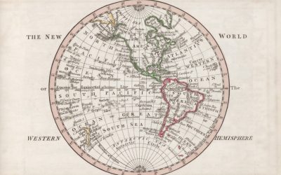
The Five Oceans and Seven Continents
The Earth’s surface is divided into five major oceans: the Pacific, Atlantic, Indian, Southern (or Antarctic), and Arctic Oceans. These vast bodies of water play a crucial role in regulating the Earth’s climate and supporting diverse marine ecosystems. The oceans also serve as important transportation routes and a source of food and other natural resources for human societies around the world.
In addition to the oceans, the Earth’s landmasses are divided into seven continents: Africa, Antarctica, Asia, Europe, North America, Australia (or Oceania), and South America. Each continent has its own unique physical and cultural characteristics, shaped by millions of years of geological processes and human history. From the deserts of Africa to the rainforests of South America, the continents offer a rich tapestry of landscapes and environments for exploration and study.
Major Mountain Ranges and Deserts
The Earth’s surface is also marked by major mountain ranges and deserts that have shaped the planet’s physical and cultural landscapes. The Himalayas, for example, are the highest mountain range in the world and are home to diverse ecosystems and cultures in countries such as India, Nepal, and Bhutan. The Andes in South America, the Rockies in North America, and the Alps in Europe are other prominent mountain ranges that have influenced human settlement patterns and economic activities.
Deserts cover about one-third of the Earth’s land surface and are characterized by low precipitation and extreme temperatures. The Sahara Desert in Africa is the largest hot desert in the world, while the Gobi Desert in Asia is one of the largest cold deserts. Deserts are not only home to unique flora and fauna but have also been important trade routes and cultural crossroads throughout history.
Climate Zones and Biomes
The Earth’s climate is influenced by a variety of factors, including latitude, altitude, ocean currents, and prevailing winds. As a result, the planet is divided into different climate zones, each with its own characteristic weather patterns and ecosystems. The equator, for example, experiences a tropical climate with high temperatures and heavy rainfall, while the polar regions have a cold and dry climate.
These climate zones give rise to different biomes, or large ecological areas characterized by distinct plant and animal communities. The tropical rainforest biome, found near the equator, is home to a diverse array of species and is vital for regulating the Earth’s climate. The grasslands biome, found in regions such as the African savannah and North American prairies, supports grazing animals and has been important for human agriculture throughout history.
Human Geography and Population Distribution
Human geography examines the ways in which people and their activities are distributed across the Earth’s surface. It encompasses topics such as population growth, migration patterns, urbanization, and cultural diversity. Understanding human geography is crucial for addressing global challenges such as poverty, inequality, and environmental degradation.
Population distribution is uneven across the world, with some regions experiencing rapid population growth while others are declining. The majority of the world’s population lives in Asia, particularly in countries such as China and India. Urban areas are also growing rapidly, with more than half of the world’s population now living in cities. This trend has significant implications for infrastructure development, resource management, and social inequality.
Historical and Cultural Geography
Historical geography examines how human activities have shaped the Earth’s landscapes over time. It explores topics such as colonialism, trade routes, and the rise and fall of empires. Cultural geography focuses on how human cultures have developed in different regions of the world and how they interact with their environments.
The Silk Road, for example, was an ancient trade route that connected China with Europe and facilitated the exchange of goods, ideas, and technologies across Eurasia. This historical trade route had a profound impact on the development of cultures and economies along its path. Similarly, cultural geographers study how different societies have adapted to their environments through practices such as agriculture, architecture, and religious beliefs.
The Importance of Geographic Knowledge
Geographic knowledge is crucial for addressing global challenges such as climate change, resource management, and international development. By understanding world geography, we can better appreciate the environmental, cultural, and economic challenges facing different regions of the world. This knowledge is crucial for addressing global issues such as climate change, resource management, and international development.
Geographic knowledge also helps us to understand our interconnectedness with other regions of the world. By studying world geography, we can gain a deeper appreciation for the diversity of our planet and the interconnectedness of its various regions. This understanding can foster a sense of global citizenship and empathy for people from different cultures and backgrounds.
In conclusion, world geography is a complex and multifaceted field that encompasses both physical and human aspects of the Earth’s landscapes. By studying world geography, we can gain a deeper appreciation for the diversity of our planet and the interconnectedness of its various regions. This knowledge is crucial for addressing global challenges such as climate change, resource management, and international development. It also helps us to understand our interconnectedness with other regions of the world and fosters a sense of global citizenship.
FAQs
What is world geography?
World geography is the study of the Earth’s landscapes, environments, and the relationships between people and their environments. It encompasses the physical features of the Earth, as well as the human activity that takes place on it.
Why is world geography important?
World geography is important because it helps us understand the world around us. It provides insights into the physical and human processes that shape our planet, and helps us make informed decisions about how to interact with our environment.
What are the main branches of world geography?
The main branches of world geography include physical geography, which focuses on the Earth’s natural features and processes, and human geography, which examines the relationships between people and their environments.
How does world geography impact our daily lives?
World geography impacts our daily lives in numerous ways, from influencing the weather and climate we experience, to shaping the availability of natural resources and influencing the distribution of populations and cultures around the world.
What are some key concepts in world geography?
Key concepts in world geography include location, place, human-environment interaction, movement, and region. These concepts help geographers understand and interpret the world around them.
How Geography Influences World Records
Altitude plays a pivotal role in shaping athletic performance, particularly in endurance sports. As athletes ascend to higher elevations, the air pressure decreases, leading to a reduction in the availability of oxygen. This phenomenon can significantly affect an athlete’s ability to perform at their peak. For instance, elite runners and cyclists often train at high altitudes to acclimatise their bodies to lower oxygen levels, which can enhance their performance when they return to sea level. The physiological adaptations that occur during this acclimatisation process include increased red blood cell production and improved oxygen transport efficiency. Consequently, athletes who effectively harness the benefits of altitude training can experience marked improvements in their endurance capabilities, allowing them to push the boundaries of their performance. However, the impact of altitude is not universally beneficial; it can also present formidable challenges. Athletes competing at high altitudes may experience symptoms of altitude sickness, which can include headaches, nausea, and fatigue. These symptoms can hinder performance and may even lead to disqualification in extreme cases. Moreover, the psychological aspect of competing in such conditions cannot be overlooked. The mental fortitude required to overcome the discomfort associated with high-altitude events is immense. Athletes must not only contend with the physical demands but also maintain focus and determination amidst the challenges posed by their environment. Thus, while altitude can serve as a double-edged sword, it remains a critical factor in the realm of athletic performance, influencing both training regimens and competitive outcomes. Summary Altitude can significantly impact athletic performance, with higher altitudes leading to decreased oxygen levels and reduced performance. Climate plays a crucial role in breaking...
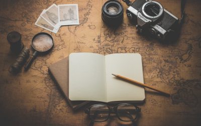
The History of Cartography: From Ancient Maps to Google Earth
Cartography, the art and science of map-making, has been an integral part of human history, serving as a vital tool for navigation, exploration, and understanding our world. From the earliest depictions of land and sea to the sophisticated digital maps we rely on today, cartography has evolved dramatically over the centuries. It is not merely a technical discipline; it embodies a rich tapestry of cultural, political, and scientific narratives that reflect humanity’s quest for knowledge and connection. Maps have the power to shape perceptions, influence decisions, and even alter the course of history, making the study of cartography both fascinating and essential. The significance of cartography extends beyond its practical applications; it is a reflection of the societies that create them. Each map tells a story, revealing the priorities, beliefs, and limitations of its time. As we delve into the history of cartography, we uncover the interplay between geography and culture, as well as the technological advancements that have propelled this field forward. The journey through cartography’s past not only highlights the ingenuity of early map-makers but also sets the stage for understanding contemporary mapping practices and their implications for our future. Summary Cartography is the art and science of map-making, and it has evolved significantly over time. Ancient maps and pioneering cartographers laid the foundation for early cartography, shaping the way we view the world. The Age of Exploration and the Golden Age of Cartography saw a surge in map-making and exploration, leading to more accurate and detailed maps. Modern cartography and Geographic Information Systems (GIS) have revolutionised the way we collect, analyse, and present geographic data. The...
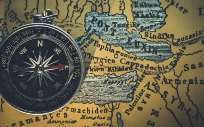
How to Read a Map: The Basics of Map Interpretation
The key, or legend, of a map serves as an essential guide, providing the necessary information to decode the symbols and colours that represent various features of the landscape. It is a crucial component that allows users to interpret the map accurately, transforming abstract symbols into tangible real-world elements. For instance, a blue line may signify a river, while a green area could indicate a forest or park. Without this vital tool, navigating through unfamiliar terrain would be akin to deciphering a foreign language without a dictionary. The key not only clarifies what each symbol represents but also often includes information about the scale of the map, which is indispensable for understanding distances and dimensions. Moreover, the key can vary significantly from one map to another, reflecting the specific focus and purpose of each cartographic representation. A topographical map may include intricate details such as elevation changes and land use, while a road map might prioritise transportation routes and urban areas. This diversity in mapping styles necessitates a thorough examination of the key before embarking on any journey. By familiarising oneself with the symbols and their meanings, one can enhance their navigational skills and ensure a more efficient exploration of the environment. Thus, understanding the key is not merely an academic exercise; it is a practical necessity for anyone seeking to traverse new landscapes with confidence and clarity. Summary Understanding the key is essential for interpreting symbols and colours on a map Using coordinates and grid references helps pinpoint specific locations on a map Orienting the map correctly ensures the right direction is always known Identifying landmarks and features...

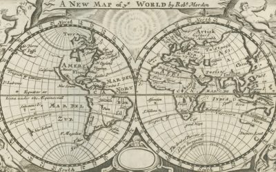
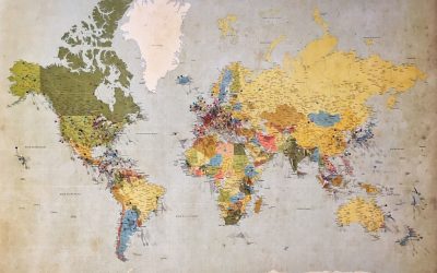
Cartography and Maps
The history of cartography is a fascinating chronicle that traces humanity’s quest to understand and represent the world around us. From the earliest cave drawings to the sophisticated digital maps of today, the evolution of map-making reflects not only advancements in technology but also shifts in cultural perspectives and scientific understanding. Ancient civilisations, such as the Babylonians and Greeks, laid the groundwork for cartographic practices, producing rudimentary maps that depicted their known world. The Greeks, particularly figures like Ptolemy, introduced concepts of latitude and longitude, which provided a framework for more accurate representations of geographical features. These early maps were often imbued with mythological elements, revealing how societies interpreted their surroundings through a blend of observation and imagination. As the centuries progressed, cartography underwent significant transformations, particularly during the Age of Exploration in the 15th and 16th centuries. This period marked a surge in maritime exploration, leading to the creation of more detailed and expansive maps that reflected newfound knowledge of distant lands. The advent of printing technology allowed for the mass production of maps, making them more accessible to the public and fostering a greater interest in geography. Notable cartographers such as Gerardus Mercator developed innovative projection techniques that enabled sailors to navigate more effectively across vast oceans. The interplay between exploration, science, and art during this era not only enriched cartographic practices but also shaped global perceptions of geography, influencing trade routes, colonisation efforts, and cultural exchanges. Summary Cartography has a rich history dating back to ancient times, with maps evolving from simple drawings to sophisticated digital representations. Maps play a crucial role in modern society, aiding...

The Geography of Waste Management and Recycling
Geography plays a pivotal role in shaping the strategies and effectiveness of waste management systems across the globe. The physical characteristics of a region, including its terrain, climate, and population density, significantly influence how waste is collected, processed, and disposed of. For instance, densely populated urban areas often face unique challenges due to the sheer volume of waste generated, necessitating sophisticated collection and recycling systems. In contrast, rural regions may struggle with limited infrastructure and resources, leading to different waste management practices. The geographical layout can also dictate the types of waste produced; coastal areas may generate more marine debris, while industrial zones might produce hazardous waste that requires specialised handling. Moreover, the availability of land for waste disposal is heavily influenced by geography. In regions where land is scarce or expensive, such as in many metropolitan areas, the pressure to develop efficient waste management systems becomes even more pronounced. This can lead to innovative solutions such as vertical landfills or waste-to-energy plants that convert refuse into usable energy. Conversely, in areas with abundant land, there may be a tendency to rely on traditional landfill methods, which can have long-term environmental consequences. Thus, geography not only dictates the immediate logistics of waste management but also shapes the broader environmental policies and practices that govern how societies deal with their refuse. Summary Geography plays a significant role in waste management, affecting access to recycling facilities and waste disposal options. Regional differences in recycling initiatives can be influenced by factors such as population density, economic resources, and government policies. Urban areas face unique waste management challenges, including limited space for landfill...
Terrain and Topography of Saint Kitts and Nevis: mountains, valleys, and plains.
Saint Kitts and Nevis, a twin-island nation nestled in the Caribbean Sea, is a veritable gem that boasts a rich tapestry of natural beauty, cultural heritage, and historical significance. This enchanting archipelago, the smallest country in the Western Hemisphere, is renowned for its stunning landscapes, which range from majestic mountains to lush valleys and serene plains. The islands are not only a paradise for tourists seeking sun-soaked beaches and vibrant marine life but also a treasure trove of biodiversity and ecological wonders. The unique geographical features of Saint Kitts and Nevis have played a pivotal role in shaping the islands’ ecosystems, influencing both the flora and fauna that thrive here, as well as the cultural practices of its inhabitants. The allure of Saint Kitts and Nevis extends beyond its picturesque scenery; it is steeped in a rich history that reflects the confluence of indigenous cultures, colonial influences, and the resilience of its people. The islands were originally inhabited by the Carib and Arawak peoples before European colonisation introduced new dynamics to the region. Today, the legacy of this complex history is evident in the vibrant traditions, music, and culinary delights that characterise the islands. As we delve deeper into the diverse terrain of Saint Kitts and Nevis, we will uncover how its majestic mountains, lush valleys, and serene plains not only define the physical landscape but also contribute to the cultural identity and environmental sustainability of this remarkable nation. Summary Saint Kitts and Nevis is a stunning Caribbean island nation known for its diverse terrain and topography. The majestic mountains of Saint Kitts and Nevis offer breathtaking views and...
Climate Zones of Saint Kitts and Nevis: Different climate regions Of Saint Kitts and Nevis
Saint Kitts and Nevis, a twin-island nation nestled in the Caribbean Sea, is renowned for its stunning landscapes, rich history, and vibrant culture. This small yet captivating country is the smallest sovereign state in the Western Hemisphere, both in terms of area and population. The islands are characterised by their lush greenery, volcanic mountains, and pristine beaches, making them a popular destination for tourists seeking both relaxation and adventure. The capital city, Basseterre, located on Saint Kitts, serves as the political and economic hub of the nation, while Nevis, known for its tranquil atmosphere and historical significance, offers a more laid-back experience. The islands’ unique geographical features and cultural heritage contribute to their appeal, drawing visitors from around the globe. The climate of Saint Kitts and Nevis plays a pivotal role in shaping the lifestyle of its inhabitants and the experiences of its visitors. The islands are situated within a tropical climate zone, which influences not only the natural environment but also the agricultural practices and tourism industry. The diverse climatic conditions across the islands create a rich tapestry of ecosystems, ranging from lush rainforests to arid landscapes. Understanding these climatic zones is essential for appreciating the ecological diversity of Saint Kitts and Nevis, as well as for recognising the challenges and opportunities they present for sustainable development. As we delve into the various climate zones that characterise this enchanting nation, we will uncover how they impact both the local populace and the thriving tourism sector. Summary Saint Kitts and Nevis is a small island nation in the Caribbean known for its beautiful beaches and lush landscapes. The tropical...
Political Boundaries of Saint Kitts and Nevis: Provinces, Districts, or Historical Boundaries.
Saint Kitts and Nevis, a twin-island nation nestled in the Caribbean Sea, is renowned for its stunning landscapes, rich history, and vibrant culture. This small yet significant country, which is the smallest sovereign state in the Western Hemisphere both in terms of area and population, comprises two volcanic islands: Saint Kitts, the larger of the two, and Nevis, which lies to the southeast. The islands are characterised by lush rainforests, pristine beaches, and a mountainous terrain that offers breathtaking views of the surrounding ocean. The capital city, Basseterre, located on Saint Kitts, serves as the political and economic hub of the nation, while Charlestown, the capital of Nevis, is known for its colonial architecture and historical significance. The unique blend of African, European, and indigenous influences has shaped the cultural identity of Saint Kitts and Nevis, making it a fascinating destination for tourists and a vibrant home for its residents. The nation’s economy is primarily driven by tourism, agriculture, and financial services. The picturesque landscapes and warm climate attract visitors from around the globe, eager to experience the islands’ natural beauty and rich cultural heritage. The sugar industry once dominated the economy, but as this sector declined, the government shifted its focus towards developing tourism and offshore banking. This transition has not only diversified the economy but has also led to increased investment in infrastructure and services. Despite its small size, Saint Kitts and Nevis plays a significant role in regional politics and is a member of various international organisations, including the United Nations and the Organisation of Eastern Caribbean States. The islands’ strategic location has historically made them...
History of Saint Kitts and Nevis
Before the arrival of European explorers, the islands of Saint Kitts and Nevis were inhabited by indigenous peoples, primarily the Arawaks and Caribs. The Arawaks, who were the first to settle in the region, are believed to have arrived around 2000 BC, bringing with them a rich culture that revolved around agriculture, fishing, and pottery. They cultivated crops such as cassava, sweet potatoes, and maize, which formed the backbone of their diet. Their society was organised into small, semi-nomadic communities that thrived on the natural resources available to them. The Arawaks were known for their intricate pottery and basket weaving, which showcased their artistic skills and connection to the land. However, their peaceful existence was disrupted by the arrival of the more aggressive Caribs, who migrated from South America around 1200 AD. The Caribs were skilled warriors and seafarers, and they quickly established dominance over the Arawaks, leading to significant cultural exchanges and conflicts. The Caribs brought with them a different way of life that was more militaristic and hierarchical than that of the Arawaks. They were adept at fishing and hunting, utilising canoes for transportation and trade between islands. Their society was structured around chiefdoms, with leaders known as “caciques” who held significant power and influence. The Caribs also engaged in warfare with neighbouring tribes, which allowed them to expand their territory and control over resources. The arrival of Europeans in the late 15th century marked a turning point for these indigenous populations. The introduction of new diseases by European explorers decimated the native populations, leading to a dramatic decline in their numbers. By the time the British...

Population Density of Saint Kitts and Nevis
Saint Kitts and Nevis, a twin-island nation nestled in the Caribbean Sea, is renowned for its stunning landscapes, rich history, and vibrant culture. The islands, which are the smallest sovereign state in the Western Hemisphere, boast a unique blend of natural beauty and historical significance. Saint Kitts, the larger of the two islands, is characterised by its lush mountains and volcanic terrain, while Nevis, known for its picturesque beaches and charming colonial architecture, offers a more tranquil atmosphere. Together, they form a nation that is not only a popular tourist destination but also a fascinating case study in demographic trends and population dynamics. The islands’ population, though relatively small, is a tapestry of diverse cultures and ethnicities, reflecting centuries of colonial influence and migration. The demographic landscape of Saint Kitts and Nevis is shaped by various factors, including historical events, economic opportunities, and social structures. As the nation grapples with modern challenges such as urbanisation and environmental sustainability, understanding the intricacies of its population density becomes increasingly important. Population density, defined as the number of people living per unit area, serves as a critical indicator of how resources are allocated and how communities develop. In the context of Saint Kitts and Nevis, examining population density reveals insights into the islands’ social fabric, economic viability, and future prospects. This article delves into the nuances of population density in this Caribbean nation, exploring its historical trends, current implications, and future outlook. Summary Saint Kitts and Nevis is a small island nation in the Caribbean with a rich history and unique culture. The population density of Saint Kitts and Nevis is relatively...

Natural Resources of Saint Kitts and Nevis: Where Natural Resources are located In Saint Kitts and Nevis
Saint Kitts and Nevis, a twin-island nation nestled in the Caribbean Sea, is renowned for its stunning landscapes, vibrant culture, and rich biodiversity. The natural resources of this small nation are not only vital for its economy but also play a crucial role in sustaining the livelihoods of its inhabitants. The islands boast a variety of resources, ranging from fertile agricultural land to abundant marine life, all of which contribute to the unique character and resilience of this nation. As the world increasingly turns its attention to sustainable practices, the management and conservation of these resources have become paramount, ensuring that future generations can continue to benefit from the natural wealth that Saint Kitts and Nevis has to offer. The islands’ geographical features, including volcanic mountains, lush rainforests, and pristine coastlines, create a diverse ecosystem that supports a wide array of flora and fauna. This natural diversity is not only a source of beauty but also a foundation for economic activities such as agriculture, fishing, and tourism. However, the delicate balance between utilising these resources and preserving them for future generations poses significant challenges. As climate change and human activity threaten the integrity of these ecosystems, it becomes increasingly important to explore the various natural resources available in Saint Kitts and Nevis and to understand their potential for sustainable development. Summary Saint Kitts and Nevis is a small island nation in the Caribbean with rich natural resources. The agricultural resources of Saint Kitts and Nevis include sugar cane, bananas, and livestock. The mineral resources of Saint Kitts and Nevis are limited, with deposits of volcanic stone and sand. The...
Cultural or Historical Sites of Saint Kitts and Nevis: Important Cultural Landmarks or Historical Sites In Saint Kitts and Nevis
Nestled on the verdant hills of St. Kitts, Brimstone Hill Fortress National Park stands as a testament to the island’s rich colonial history and military architecture. This UNESCO World Heritage Site, often referred to as the “Gibraltar of the West Indies,” boasts an impressive array of fortifications that date back to the 17th and 18th centuries. The fortress was constructed by the British to protect their interests in the Caribbean, and its strategic location offers breathtaking panoramic views of the surrounding landscape, including the Caribbean Sea and neighbouring islands. Visitors to Brimstone Hill can explore its well-preserved ramparts, bastions, and barracks, which provide a fascinating glimpse into the past. The site is not only a historical marvel but also a natural wonder, with lush greenery enveloping the stone structures, creating a picturesque setting that enchants all who visit. Walking through the fortress, one can almost hear the echoes of history reverberating through its walls. The site is home to several interpretive displays that narrate the story of its construction and the various battles fought over its control. The impressive architecture reflects the ingenuity of military engineers of the time, with thick stone walls designed to withstand cannon fire and a layout that maximises defensive capabilities. As visitors ascend to the highest points of the fortress, they are rewarded with stunning vistas that stretch across the horizon, making it an ideal spot for photography enthusiasts and nature lovers alike. The combination of historical significance and natural beauty makes Brimstone Hill Fortress National Park a must-visit destination for anyone seeking to understand the cultural heritage of St. Kitts. Summary Brimstone Hill...