World Geography
Geography is the study of the Earth’s landscapes, environments, and the relationships between people and their surroundings. It encompasses both the physical aspects of the Earth, such as its landforms, bodies of water, and climate, as well as the human aspects, including population distribution, cultures, and economies. World geography is a broad field that seeks to understand the complexities of our planet and how humans interact with it. By studying world geography, we can gain a deeper appreciation for the diversity of our planet and the interconnectedness of its various regions.
Geography is a multidisciplinary field that draws on elements of physical science, social science, and humanities. It involves the use of maps, spatial analysis, and geographic information systems (GIS) to understand the Earth’s surface and the processes that shape it. World geography also encompasses the study of human geography, which examines the ways in which people and their activities are distributed across the Earth. By understanding world geography, we can better appreciate the environmental, cultural, and economic challenges facing different regions of the world. This knowledge is crucial for addressing global issues such as climate change, resource management, and international development.
The Five Oceans and Seven Continents
The Earth’s surface is divided into five major oceans: the Pacific, Atlantic, Indian, Southern (or Antarctic), and Arctic Oceans. These vast bodies of water play a crucial role in regulating the Earth’s climate and supporting diverse marine ecosystems. The oceans also serve as important transportation routes and a source of food and other natural resources for human societies around the world.
In addition to the oceans, the Earth’s landmasses are divided into seven continents: Africa, Antarctica, Asia, Europe, North America, Australia (or Oceania), and South America. Each continent has its own unique physical and cultural characteristics, shaped by millions of years of geological processes and human history. From the deserts of Africa to the rainforests of South America, the continents offer a rich tapestry of landscapes and environments for exploration and study.
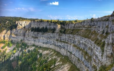
Major Mountain Ranges and Deserts
The Earth’s surface is also marked by major mountain ranges and deserts that have shaped the planet’s physical and cultural landscapes. The Himalayas, for example, are the highest mountain range in the world and are home to diverse ecosystems and cultures in countries such as India, Nepal, and Bhutan. The Andes in South America, the Rockies in North America, and the Alps in Europe are other prominent mountain ranges that have influenced human settlement patterns and economic activities.
Deserts cover about one-third of the Earth’s land surface and are characterized by low precipitation and extreme temperatures. The Sahara Desert in Africa is the largest hot desert in the world, while the Gobi Desert in Asia is one of the largest cold deserts. Deserts are not only home to unique flora and fauna but have also been important trade routes and cultural crossroads throughout history.
Climate Zones and Biomes
The Earth’s climate is influenced by a variety of factors, including latitude, altitude, ocean currents, and prevailing winds. As a result, the planet is divided into different climate zones, each with its own characteristic weather patterns and ecosystems. The equator, for example, experiences a tropical climate with high temperatures and heavy rainfall, while the polar regions have a cold and dry climate.
These climate zones give rise to different biomes, or large ecological areas characterized by distinct plant and animal communities. The tropical rainforest biome, found near the equator, is home to a diverse array of species and is vital for regulating the Earth’s climate. The grasslands biome, found in regions such as the African savannah and North American prairies, supports grazing animals and has been important for human agriculture throughout history.
Human Geography and Population Distribution
Human geography examines the ways in which people and their activities are distributed across the Earth’s surface. It encompasses topics such as population growth, migration patterns, urbanization, and cultural diversity. Understanding human geography is crucial for addressing global challenges such as poverty, inequality, and environmental degradation.
Population distribution is uneven across the world, with some regions experiencing rapid population growth while others are declining. The majority of the world’s population lives in Asia, particularly in countries such as China and India. Urban areas are also growing rapidly, with more than half of the world’s population now living in cities. This trend has significant implications for infrastructure development, resource management, and social inequality.
Historical and Cultural Geography
Historical geography examines how human activities have shaped the Earth’s landscapes over time. It explores topics such as colonialism, trade routes, and the rise and fall of empires. Cultural geography focuses on how human cultures have developed in different regions of the world and how they interact with their environments.
The Silk Road, for example, was an ancient trade route that connected China with Europe and facilitated the exchange of goods, ideas, and technologies across Eurasia. This historical trade route had a profound impact on the development of cultures and economies along its path. Similarly, cultural geographers study how different societies have adapted to their environments through practices such as agriculture, architecture, and religious beliefs.
The Importance of Geographic Knowledge
Geographic knowledge is crucial for addressing global challenges such as climate change, resource management, and international development. By understanding world geography, we can better appreciate the environmental, cultural, and economic challenges facing different regions of the world. This knowledge is crucial for addressing global issues such as climate change, resource management, and international development.
Geographic knowledge also helps us to understand our interconnectedness with other regions of the world. By studying world geography, we can gain a deeper appreciation for the diversity of our planet and the interconnectedness of its various regions. This understanding can foster a sense of global citizenship and empathy for people from different cultures and backgrounds.
In conclusion, world geography is a complex and multifaceted field that encompasses both physical and human aspects of the Earth’s landscapes. By studying world geography, we can gain a deeper appreciation for the diversity of our planet and the interconnectedness of its various regions. This knowledge is crucial for addressing global challenges such as climate change, resource management, and international development. It also helps us to understand our interconnectedness with other regions of the world and fosters a sense of global citizenship.
FAQs
What is world geography?
World geography is the study of the Earth’s landscapes, environments, and the relationships between people and their environments. It encompasses the physical features of the Earth, as well as the human activity that takes place on it.
Why is world geography important?
World geography is important because it helps us understand the world around us. It provides insights into the physical and human processes that shape our planet, and helps us make informed decisions about how to interact with our environment.
What are the main branches of world geography?
The main branches of world geography include physical geography, which focuses on the Earth’s natural features and processes, and human geography, which examines the relationships between people and their environments.
How does world geography impact our daily lives?
World geography impacts our daily lives in numerous ways, from influencing the weather and climate we experience, to shaping the availability of natural resources and influencing the distribution of populations and cultures around the world.
What are some key concepts in world geography?
Key concepts in world geography include location, place, human-environment interaction, movement, and region. These concepts help geographers understand and interpret the world around them.

Tropical Rainforests: Why They Are the Earth’s Lungs
Tropical rainforests are amongst the most diverse and complex ecosystems on the planet. They are situated near the equator, where the climate is warm and humid, and receive a high amount of rainfall throughout the year. These forests are home to an incredible array of plant and animal species, many of which are found nowhere else on Earth. The lush vegetation, towering trees, and diverse wildlife make tropical rainforests a truly unique and remarkable environment. Tropical rainforests are found in South America, Africa, Southeast Asia, and the Pacific Islands. The Amazon Rainforest in South America is the largest tropical rainforest in the world, covering an area of over 6 million square kilometres. The Congo Rainforest in Africa and the rainforests of Borneo and New Guinea in Southeast Asia are also significant in size and biodiversity. These forests play a crucial role in regulating the Earth’s climate, providing habitat for countless species, and supporting the livelihoods of millions of people around the world. Tropical rainforests are not only important for their ecological value but also for their cultural significance. Indigenous peoples have lived in and depended on these forests for thousands of years, and their traditional knowledge and practices have contributed to the preservation of these vital ecosystems. As we continue to learn more about the importance of tropical rainforests, it becomes increasingly clear that their protection is essential for the well-being of our planet and all its inhabitants. Summary Tropical rainforests are dense forests located near the equator with high levels of rainfall and biodiversity. Tropical rainforests are often referred to as the Earth’s lungs due to their role...

The Geography of Adventure Travel
Adventure travel destinations are remarkably diverse, offering a broad spectrum of experiences for thrill-seekers and nature enthusiasts. From the lofty peaks of the Himalayas to the dense rainforests of the Amazon, there is an abundance of options for those seeking an adrenaline rush. Whether it involves trekking through remote mountain ranges, white-water rafting down turbulent rivers, or exploring ancient ruins in far-flung corners of the world, adventure travel destinations cater to a variety of interests and preferences. The diversity of these destinations also extends to the cultural experiences they offer, with opportunities to immerse oneself in local traditions and customs, and interact with indigenous communities. Whether it’s the rugged landscapes of Patagonia, the vast deserts of Namibia, or the pristine wilderness of Alaska, adventure travel destinations offer a wealth of experiences for those seeking to challenge their boundaries and explore the natural world. The diversity of adventure travel destinations also extends to the activities on offer, with options ranging from high-octane pursuits such as rock climbing and skydiving, to more leisurely activities like wildlife safaris and birdwatching. Whether it’s diving with sharks in the Galapagos Islands, mountain biking through the rugged terrain of New Zealand, or paragliding over the Swiss Alps, adventure travel destinations cater to a wide range of interests and skill levels. The diversity of these destinations also means that there is something for everyone, whether you’re a seasoned adrenaline enthusiast or a first-time adventurer looking to step out of your comfort zone. With so many options to choose from, adventure travel destinations offer a wealth of opportunities for exploration and discovery, making them an appealing choice...

Understanding Biomes: From Deserts to Rainforests
Biomes are extensive geographical regions characterised by distinct climates, flora and fauna. They are categorised based on the predominant vegetation and climatic conditions of the area. Several major biomes exist on Earth, each with its own unique characteristics and biodiversity. Understanding biomes is crucial for ecologists, conservationists and policymakers, as it aids in comprehending species distribution, ecosystem functioning and the impact of human activities on the environment. Biomes play a vital role in shaping the Earth’s biodiversity and regulating the global climate. They provide habitats for a diverse array of plants and animals, and they also influence weather patterns and nutrient cycling. By studying biomes, scientists can gain insights into the complex interactions between living organisms and their environment. This knowledge is essential for making informed decisions about land use, conservation and sustainable resource management. Summary Biomes are large geographical areas with distinct climates, flora, and fauna. Deserts are characterized by low precipitation, high temperatures, and sparse vegetation. Grasslands are characterized by moderate precipitation, grassy vegetation, and grazing animals. Tropical rainforests have high precipitation, dense vegetation, and a wide variety of animal species. Temperate forests have moderate precipitation, diverse tree species, and seasonal changes in temperature. Characteristics of Deserts Climate and Temperature Fluctuations As a result, deserts are often hot during the day and cold at night, with wide temperature fluctuations. Adaptations of Flora and Fauna The flora and fauna in deserts have adapted to survive in harsh conditions. Plants have developed mechanisms to conserve water, such as deep root systems and waxy coatings on leaves. Animals in deserts have also evolved to withstand high temperatures and scarcity of...

The Difference Between Weather and Climate
Weather and climate are two distinct concepts that are often conflated, yet they refer to separate phenomena. Weather denotes the short-term atmospheric conditions in a specific locale, including temperature, humidity, precipitation and wind speed. It is what we experience on a daily basis and can fluctuate rapidly. Climate, conversely, refers to the long-term patterns and averages of weather conditions in a particular region over an extended period, typically 30 years or more. It encompasses the average temperature, precipitation and other atmospheric conditions for a given area. Whilst weather can vary from day to day or even hour to hour, climate is more stable and predictable over longer periods. Both weather and climate are influenced by a variety of factors, including the Earth’s rotation, the tilt of its axis and the distribution of land and water. These factors interact to create the complex and dynamic systems that govern our planet’s weather and climate. Understanding the distinctions between weather and climate is crucial for making informed decisions about how to adapt to and mitigate the impacts of changing environmental conditions. Summary Weather refers to the short-term atmospheric conditions in a specific area, while climate refers to the long-term patterns of temperature, precipitation, and other atmospheric conditions. Factors influencing weather and climate include latitude, altitude, ocean currents, and prevailing winds, among others. Weather operates on a short time scale, typically ranging from minutes to weeks, while climate operates on a longer time scale, typically ranging from years to millennia. Variability in weather and climate is influenced by natural phenomena such as El Niño and La Niña, as well as human activities such...
Glaciers: Their Role in Shaping Landforms
Glaciers are vast masses of ice that form from the accumulation and compaction of snow over numerous years. They are found in polar regions and high mountainous areas. Glaciers are a crucial component of the Earth’s climate system and play a vital role in shaping the landscape. They are also a valuable source of fresh water, with many rivers and lakes being fed by glacial meltwater. Glaciers are dynamic and constantly moving, flowing under the influence of gravity. They can range in size from small ice patches to massive ice sheets that cover thousands of square kilometres. The study of glaciers, known as glaciology, is an important field of research that helps us understand the Earth’s past climate and predict future changes. Glaciers are often referred to as “rivers of ice” due to their flowing nature. They are formed when snow accumulates over time and undergoes a process of compaction and recrystallisation, turning into dense, granular ice. As more snow accumulates on top, the weight of the overlying snow compresses the lower layers into ice. Over time, the ice becomes so compacted that it begins to flow under its own weight, forming a glacier. Glaciers can move downhill due to the force of gravity, and they can also flow laterally due to the pressure exerted by the weight of the ice. The movement of glaciers is a slow process, but it is relentless, shaping the landscape as it progresses. Glaciers can erode rock and soil, transport sediment, and deposit it in new locations, creating unique landforms in the process. Summary Glaciers are large masses of ice that form from...

Terrain and Topography of Paraguay: mountains, valleys, and plains.
Paraguay, a landlocked country in South America, is characterised by diverse terrain and topography. The nation shares borders with Argentina to the south and southwest, Brazil to the east and northeast, and Bolivia to the northwest. Paraguay‘s landscape comprises a mixture of mountains, valleys, and plains, creating a varied and intriguing terrain. The Paraguay River, which flows through the heart of the country, significantly influences the landscape and provides essential resources for the population. The terrain and topography of Paraguay play a crucial role in shaping the country’s climate, ecosystems, and human activities, thus forming an integral aspect of the nation’s identity and development. The terrain of Paraguay is diverse, with the eastern region predominantly consisting of lowlands and plains, whilst the western region features mountain ranges and valleys. The country’s topography is heavily influenced by the Paraguay River, which serves as a vital artery for the nation, supplying water for irrigation, transportation, and hydroelectric power generation. The terrain and topography of Paraguay have also played a significant role in shaping the country’s history and culture, as well as its economic development. With such a varied landscape, Paraguay boasts a wealth of natural beauty and resources that continue to shape the nation’s identity and future. Summary Paraguay’s terrain is diverse, with mountain ranges, valleys, and plains contributing to its topography. The mountain ranges in Paraguay include the Amambay and Mbaracayu ranges, which offer stunning landscapes and biodiversity. The valleys in Paraguay, such as the Paraguay River Valley, are important for agriculture and provide fertile land for farming. The plains of Paraguay, including the Gran Chaco and the Paraná Plateau,...

Climate Zones of Paraguay: Different climate regions Of Paraguay
Paraguay, a landlocked country in South America, is characterised by diverse climate zones. The nation is divided into six primary climate regions, each with distinct characteristics and weather patterns. These climate zones encompass the tropical climate of the Chaco region, the subtropical climate of the eastern region, the humid pampas climate of the central region, the semi-arid climate of the Gran Chaco region, and the highland climate of the Paraná Plateau. Each of these climate zones plays a crucial role in shaping Paraguay‘s landscape, flora and fauna, making it a significant area of interest for naturalists and researchers. The diverse climate zones of Paraguay are influenced by a combination of factors, including its geographical location, topography and proximity to major bodies of water. Understanding these climate zones is essential for those seeking to explore the natural beauty and biodiversity of Paraguay. This article will examine each of these climate zones, exploring their unique characteristics and the impact they have on the country’s environment and ecosystems. By gaining a deeper understanding of Paraguay’s climate zones, one can appreciate the rich tapestry of natural wonders that this South American nation offers. Summary Paraguay has diverse climate zones, including tropical, subtropical, humid pampas, semiarid, and highland climates. The Chaco region experiences a tropical climate with high temperatures and distinct wet and dry seasons. The Eastern region has a subtropical climate with hot summers, mild winters, and abundant rainfall throughout the year. The Central region has a humid pampas climate with hot summers, mild winters, and significant rainfall, making it suitable for agriculture. The Gran Chaco region has a semiarid climate with low...

Political Boundaries of Paraguay: Provinces, Districts, or Historical Boundaries.
Paraguay, a landlocked country in South America, shares borders with Argentina to the south and southwest, Brazil to the east and northeast, and Bolivia to the northwest. These neighbouring countries define Paraguay‘s political boundaries and significantly influence its geopolitical landscape. The country’s political boundaries have evolved over time, shaped by historical events, territorial disputes and diplomatic negotiations. Understanding these boundaries is crucial for comprehending Paraguay’s administrative divisions, governance structure and historical context. Paraguay’s political boundaries are not solely defined by its international borders but also by its internal administrative divisions, including departments and districts. These internal boundaries play a vital role in the country’s governance and administration, as they delineate the jurisdiction of local authorities, electoral districts and administrative regions. The interplay between internal and external political boundaries profoundly impacts Paraguay’s political, social and economic dynamics. This article will explore the departments and districts of Paraguay, examine its historical boundaries and assess the impact of these political boundaries on the country’s governance. Summary Paraguay is a landlocked country in South America, bordered by Argentina, Brazil, and Bolivia. The country is divided into 17 administrative regions known as departments, each with its own capital city. Within these departments, there are 250 districts, each with its own local government and administrative structure. Paraguay’s historical boundaries have shifted over time due to conflicts and treaties with neighbouring countries. The political boundaries of Paraguay have a significant impact on governance, resource allocation, and local administration. The future of Paraguay’s political boundaries may be influenced by geopolitical changes and internal reforms. Provinces of Paraguay Paraguay is divided into 17 administrative divisions known as provinces,...

History of Paraguay
Paraguay possesses a rich history extending back to the pre-Columbian era, with archaeological evidence indicating human habitation for over 10,000 years. The indigenous peoples of Paraguay, particularly the Guarani, were the original inhabitants of the region and have significantly influenced the country’s culture and traditions. The Guarani were adept agriculturists, cultivating crops such as maize, cassava and sweet potatoes. They were also renowned for their sophisticated pottery and weaving techniques. Their society was organised into small, autonomous communities with a complex social structure emphasising kinship and communal living. The Guarani language, which remains widely spoken in Paraguay today, is a distinctive feature of their culture. Their linguistic and cultural practices have had an enduring impact on the country, with many Paraguayans strongly identifying with their indigenous heritage. The Guarani also possessed a rich spiritual tradition, believing in a pantheon of deities and spirits governing the natural world. Their religious practices encompassed elaborate ceremonies and rituals, often involving music, dance and the consumption of hallucinogenic substances. Whilst the arrival of the Spanish would later profoundly affect the indigenous peoples of Paraguay, their legacy continues to be an integral component of the country’s identity. Summary Pre-Columbian Paraguay was inhabited by various indigenous peoples, including the Guarani, who had a rich cultural and agricultural heritage. Spanish colonization and the establishment of Jesuit missions in the 17th century had a significant impact on the indigenous population and their way of life. Paraguay’s war of independence from Spain in the early 19th century led to the formation of an independent nation with a unique blend of indigenous and European influences. The Paraguayan War in...

Population Density of Paraguay
Population density refers to the number of people living in a specific area, typically measured in square kilometres or square miles. It is a crucial demographic indicator that provides insights into the distribution of people within a country or region. In Paraguay, population density varies significantly across different areas, with the majority of the population concentrated in urban centres. Understanding population density is essential for policymakers and urban planners as it influences various aspects of society, including infrastructure development, resource allocation and environmental sustainability. Paraguay, a landlocked country in South America, has a population density of approximately 17 people per square kilometre. This places it among the countries with low population density globally. However, despite the overall low population density, there are significant variations within the country, with densely populated urban areas and sparsely populated rural regions. Factors such as geography, climate and economic opportunities play a crucial role in shaping population density patterns in Paraguay. Summary Population density refers to the number of people living in a specific area, usually measured in square kilometres or square miles. Factors affecting population density in Paraguay include geographical features, economic opportunities, and government policies. Urban areas in Paraguay have higher population density compared to rural areas, leading to challenges in infrastructure and resource allocation. High population density can strain infrastructure and resources, leading to issues such as traffic congestion, housing shortages, and environmental degradation. Paraguay’s population density is lower compared to many other countries, but efforts to manage and control population density are still important for sustainable development. Factors Affecting Population Density in Paraguay Several factors contribute to the population density...

Natural Resources of Paraguay: Where Natural Resources are Located in Paraguay
Paraguay, a landlocked country in South America, possesses abundant natural resources that contribute significantly to its economy. The nation’s natural assets encompass agricultural land, mineral deposits, water bodies, forests and energy sources. These resources play a crucial role in the country’s economic development and provide employment opportunities for a substantial portion of the population. Paraguay‘s natural resources are diverse and plentiful, making it an attractive destination for investors and businesses seeking to capitalise on the country’s wealth of natural assets. Paraguay’s natural resources have been a driving force behind the country’s economic growth, particularly in the agricultural sector. The fertile soil and favourable climate have established Paraguay as a major producer and exporter of agricultural products such as soya beans, maize, wheat and cattle. In addition to agriculture, Paraguay also boasts significant mineral deposits, including iron ore, manganese, limestone and clay. These mineral resources have the potential to further boost the country’s economy through mining and export activities. Furthermore, Paraguay’s water resources, including rivers and aquifers, provide ample opportunities for hydroelectric power generation and irrigation, contributing to the country’s energy and agricultural sectors. With proper management and conservation efforts, Paraguay’s natural resources can continue to drive sustainable economic development and improve the livelihoods of its people. Summary Paraguay is rich in natural resources, including agricultural, mineral, water, forest, and energy resources. The country’s agricultural resources are diverse and include soybeans, corn, wheat, and cattle. Paraguay has significant mineral resources, including iron ore, manganese, limestone, and clay. Water resources in Paraguay are abundant, with the Paraguay River and the Paraná River providing ample water for irrigation and hydroelectric power generation....

Cultural or Historical Sites of Paraguay: Important Cultural Landmarks or Historical Sites In Paraguay
Paraguay, a landlocked country in South America, boasts a wealth of cultural and historical sites that provide insight into its rich and diverse heritage. From Jesuit missions to architectural marvels, Paraguay‘s cultural and historical landmarks serve as a testament to its intriguing past and vibrant present. The nation’s distinctive blend of indigenous, Spanish and Guarani influences is evident in its architecture, art and traditions, making it a noteworthy destination for history enthusiasts and cultural scholars. Paraguay’s cultural and historical sites reflect its complex history, which extends back to pre-Columbian times. The country’s indigenous peoples, such as the Guarani, have made a lasting impact on Paraguay’s cultural landscape, with their language, traditions and craftsmanship remaining prevalent to this day. The arrival of Spanish conquistadors in the 16th century ushered in a new era of cultural exchange, resulting in the fusion of European and indigenous influences that is apparent in Paraguay’s architecture and art. The Jesuit missions, in particular, exemplify this unique blend of cultures, showcasing the architectural skill and religious zeal of the Jesuit priests who sought to convert the indigenous peoples to Christianity. Consequently, Paraguay’s cultural and historical sites offer a compelling glimpse into the country’s multicultural heritage and the enduring legacy of its indigenous peoples. Summary Paraguay is home to a rich cultural and historical heritage, with a variety of sites that showcase its unique identity. The Jesuit Missions of La Santísima Trinidad del Paraná and Jesús de Tavarangue are UNESCO World Heritage Sites, offering a glimpse into the country’s colonial past. The National Pantheon of the Heroes is a significant monument honouring Paraguay’s military and political figures,...