World Geography
Geography is the study of the Earth’s landscapes, environments, and the relationships between people and their surroundings. It encompasses both the physical aspects of the Earth, such as its landforms, bodies of water, and climate, as well as the human aspects, including population distribution, cultures, and economies. World geography is a broad field that seeks to understand the complexities of our planet and how humans interact with it. By studying world geography, we can gain a deeper appreciation for the diversity of our planet and the interconnectedness of its various regions.
Geography is a multidisciplinary field that draws on elements of physical science, social science, and humanities. It involves the use of maps, spatial analysis, and geographic information systems (GIS) to understand the Earth’s surface and the processes that shape it. World geography also encompasses the study of human geography, which examines the ways in which people and their activities are distributed across the Earth. By understanding world geography, we can better appreciate the environmental, cultural, and economic challenges facing different regions of the world. This knowledge is crucial for addressing global issues such as climate change, resource management, and international development.
The Five Oceans and Seven Continents
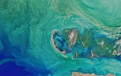
The Earth’s surface is divided into five major oceans: the Pacific, Atlantic, Indian, Southern (or Antarctic), and Arctic Oceans. These vast bodies of water play a crucial role in regulating the Earth’s climate and supporting diverse marine ecosystems. The oceans also serve as important transportation routes and a source of food and other natural resources for human societies around the world.
In addition to the oceans, the Earth’s landmasses are divided into seven continents: Africa, Antarctica, Asia, Europe, North America, Australia (or Oceania), and South America. Each continent has its own unique physical and cultural characteristics, shaped by millions of years of geological processes and human history. From the deserts of Africa to the rainforests of South America, the continents offer a rich tapestry of landscapes and environments for exploration and study.
Major Mountain Ranges and Deserts
The Earth’s surface is also marked by major mountain ranges and deserts that have shaped the planet’s physical and cultural landscapes. The Himalayas, for example, are the highest mountain range in the world and are home to diverse ecosystems and cultures in countries such as India, Nepal, and Bhutan. The Andes in South America, the Rockies in North America, and the Alps in Europe are other prominent mountain ranges that have influenced human settlement patterns and economic activities.
Deserts cover about one-third of the Earth’s land surface and are characterized by low precipitation and extreme temperatures. The Sahara Desert in Africa is the largest hot desert in the world, while the Gobi Desert in Asia is one of the largest cold deserts. Deserts are not only home to unique flora and fauna but have also been important trade routes and cultural crossroads throughout history.
Climate Zones and Biomes
The Earth’s climate is influenced by a variety of factors, including latitude, altitude, ocean currents, and prevailing winds. As a result, the planet is divided into different climate zones, each with its own characteristic weather patterns and ecosystems. The equator, for example, experiences a tropical climate with high temperatures and heavy rainfall, while the polar regions have a cold and dry climate.
These climate zones give rise to different biomes, or large ecological areas characterized by distinct plant and animal communities. The tropical rainforest biome, found near the equator, is home to a diverse array of species and is vital for regulating the Earth’s climate. The grasslands biome, found in regions such as the African savannah and North American prairies, supports grazing animals and has been important for human agriculture throughout history.
Human Geography and Population Distribution
Human geography examines the ways in which people and their activities are distributed across the Earth’s surface. It encompasses topics such as population growth, migration patterns, urbanization, and cultural diversity. Understanding human geography is crucial for addressing global challenges such as poverty, inequality, and environmental degradation.
Population distribution is uneven across the world, with some regions experiencing rapid population growth while others are declining. The majority of the world’s population lives in Asia, particularly in countries such as China and India. Urban areas are also growing rapidly, with more than half of the world’s population now living in cities. This trend has significant implications for infrastructure development, resource management, and social inequality.
Historical and Cultural Geography
Historical geography examines how human activities have shaped the Earth’s landscapes over time. It explores topics such as colonialism, trade routes, and the rise and fall of empires. Cultural geography focuses on how human cultures have developed in different regions of the world and how they interact with their environments.
The Silk Road, for example, was an ancient trade route that connected China with Europe and facilitated the exchange of goods, ideas, and technologies across Eurasia. This historical trade route had a profound impact on the development of cultures and economies along its path. Similarly, cultural geographers study how different societies have adapted to their environments through practices such as agriculture, architecture, and religious beliefs.
The Importance of Geographic Knowledge
Geographic knowledge is crucial for addressing global challenges such as climate change, resource management, and international development. By understanding world geography, we can better appreciate the environmental, cultural, and economic challenges facing different regions of the world. This knowledge is crucial for addressing global issues such as climate change, resource management, and international development.
Geographic knowledge also helps us to understand our interconnectedness with other regions of the world. By studying world geography, we can gain a deeper appreciation for the diversity of our planet and the interconnectedness of its various regions. This understanding can foster a sense of global citizenship and empathy for people from different cultures and backgrounds.
In conclusion, world geography is a complex and multifaceted field that encompasses both physical and human aspects of the Earth’s landscapes. By studying world geography, we can gain a deeper appreciation for the diversity of our planet and the interconnectedness of its various regions. This knowledge is crucial for addressing global challenges such as climate change, resource management, and international development. It also helps us to understand our interconnectedness with other regions of the world and fosters a sense of global citizenship.
FAQs
What is world geography?
World geography is the study of the Earth’s landscapes, environments, and the relationships between people and their environments. It encompasses the physical features of the Earth, as well as the human activity that takes place on it.
Why is world geography important?
World geography is important because it helps us understand the world around us. It provides insights into the physical and human processes that shape our planet, and helps us make informed decisions about how to interact with our environment.
What are the main branches of world geography?
The main branches of world geography include physical geography, which focuses on the Earth’s natural features and processes, and human geography, which examines the relationships between people and their environments.
How does world geography impact our daily lives?
World geography impacts our daily lives in numerous ways, from influencing the weather and climate we experience, to shaping the availability of natural resources and influencing the distribution of populations and cultures around the world.
What are some key concepts in world geography?
Key concepts in world geography include location, place, human-environment interaction, movement, and region. These concepts help geographers understand and interpret the world around them.
Analyzing how specific climate zones, such as tropical and subtropical, are prone to hurricanes, cyclones, and monsoons.
Climate zones are geographical areas with similar weather patterns, temperature ranges and environmental conditions. These zones are determined by a combination of factors, including latitude, altitude, proximity to bodies of water and prevailing wind patterns. Understanding climate zones is crucial for predicting weather patterns, agricultural practices and the impact of climate change on different regions. There are several main climate zones, including tropical, subtropical, temperate, polar and arid. Each of these zones has distinct characteristics that influence the flora, fauna and human activities within them. In this article, we shall focus on tropical and subtropical climate zones, exploring the unique features of each and the challenges they present in terms of extreme weather events such as hurricanes, cyclones and monsoons. Summary Climate zones categorise different regions based on their typical weather patterns and temperatures. Tropical climate zones are characterised by high temperatures, humidity, and heavy rainfall. Hurricanes in tropical climate zones are influenced by warm ocean waters and low atmospheric pressure. Subtropical climate zones experience milder temperatures and are prone to cyclones, which are intense low-pressure systems. Monsoons can affect different climate zones, bringing heavy rainfall and seasonal changes in wind patterns. Understanding Tropical Climate Zones Characteristics of Tropical Climate Zones The combination of warm temperatures and ample moisture creates ideal conditions for diverse ecosystems, including rainforests, savannas, and wetlands. Extreme Weather Events Tropical climate zones are also prone to extreme weather events such as hurricanes, typhoons, and monsoons. These phenomena are fuelled by the warm ocean waters and the Earth’s rotation, which create the perfect conditions for the formation of powerful storms. The impact of these events can...
Tropical Storms and Monsoons: The Role of Climate Zones in Extreme Weather
Climate zones are geographical areas with similar weather patterns, including temperature, humidity and precipitation. There are five primary climate zones: tropical, dry, temperate, continental and polar. Each zone has distinct characteristics that influence the type of weather experienced in that region. Tropical climate zones are located near the equator and experience high temperatures and humidity throughout the year. These regions typically have a wet and dry season, with heavy rainfall during the wet season. Dry climate zones are found in arid and semi-arid regions, with low precipitation and high temperatures. Temperate climate zones have moderate temperatures and distinct seasons, including warm summers and cold winters. Continental climate zones experience extreme temperature variations between summer and winter, with hot summers and cold winters. Polar climate zones are located near the North and South Poles and have extremely cold temperatures and little precipitation. Understanding climate zones is essential for predicting and preparing for weather patterns and extreme events such as tropical storms and monsoons. Each climate zone has its own unique characteristics that influence the formation and impact of these weather phenomena. Tropical Storms: Formation and Impact Tropical storms, also known as hurricanes or typhoons, are powerful weather systems that form over warm ocean waters in tropical climate zones. These storms are characterised by strong winds, heavy rainfall and storm surges, which can cause widespread destruction and loss of life. The formation of tropical storms is influenced by several factors, including warm ocean temperatures, high humidity and low wind shear. Tropical storms typically form when warm ocean waters evaporate and rise into the atmosphere, creating an area of low pressure. As...
Exploring how diverse climates have influenced the culture, clothing, architecture, and lifestyles of different regions.
The world is a diverse and varied place, with a wide range of climates and environments that have shaped the cultures and traditions of different regions. From the icy tundras of the Arctic to the sweltering deserts of the Middle East, each climate has had a profound impact on the way people live, work and interact with their surroundings. The influence of climate on culture can be observed in various aspects, including clothing choices and architectural styles. Understanding the ways in which climate shapes culture is essential for appreciating the rich tapestry of human experience that exists around the globe. The impact of climate on culture extends beyond the physical environment to encompass social and economic aspects of society. In regions with harsh climates, people have developed unique methods of survival and prosperity, leading to the establishment of distinct cultural practices and traditions. Examples include the nomadic herding cultures of Mongolia and the fishing communities of coastal regions, where the ways in which people interact with their environment are deeply intertwined with the local climate. By examining the ways in which climate has influenced different cultures, one can gain a deeper appreciation for the diversity of human experience and the resilience of people in adapting to their surroundings. Summary Diverse climates around the world have a significant influence on the cultural practices and traditions of different regions. Climate plays a crucial role in shaping the clothing and fashion choices of people, reflecting the need for practical and functional attire. Architecture in different regions is a reflection of the local climate, with designs and materials adapted to suit the environmental...

Political Boundaries of Niger: Provinces, Districts, or Historical Boundaries.
Niger, officially the Republic of Niger, is a landlocked country situated in West Africa. It shares borders with seven nations: Algeria to the northwest, Libya to the northeast, Chad to the east, Nigeria and Benin to the south, Burkina Faso to the southwest, and Mali to the west. Encompassing an area of over 1.2 million square kilometres, Niger is the largest country in West Africa. The nation’s political boundaries are defined by these international borders and its internal administrative divisions, which include regions and departments. These boundaries are integral to the country’s governance, economy, and social structure. The political boundaries of Niger have undergone changes throughout history, influenced by historical, cultural, and geopolitical factors. The country’s diverse ethnic groups and traditional kingdoms have also contributed significantly to the shaping of its political boundaries. A thorough understanding of Niger’s political boundaries is crucial for comprehending the nation’s governance and development. This article will examine the regions and departments of Niger, explore its historical boundaries, compare its political boundaries with neighbouring countries, and evaluate the impact of these boundaries on governance. Furthermore, it will discuss potential future developments in Niger’s political boundaries and their implications for the country’s future. By analysing these aspects, one can gain a comprehensive understanding of Niger’s political landscape and its regional significance. Summary Niger’s political boundaries are defined by its borders with seven different countries, including Nigeria, Chad, and Algeria. The country is divided into eight administrative regions, each further divided into departments and communes. The districts of Niger are the smallest administrative units, with each region containing several districts. Historical boundaries of Niger have been...

Climate Zones of Niger: Different climate regions Of Niger
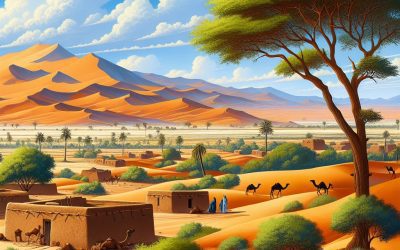
Niger, a landlocked country in West Africa, is renowned for its diverse climate zones, each possessing unique characteristics and challenges. The nation is situated in the Sahel region, a transitional zone between the Sahara Desert to the north and the savannas and forests to the south. This geographical location gives rise to a variety of climate zones, ranging from the arid desert in the north to the more temperate highlands in the south. Understanding these climate zones is crucial for comprehending the environmental, agricultural and social dynamics of Niger. Niger’s climate zones are influenced by several factors, including its proximity to the Sahara Desert, the movement of the Intertropical Convergence Zone (ITCZ), and the presence of mountain ranges. These factors contribute to the varying levels of rainfall, temperature and vegetation across the country. The climate zones also play a significant role in shaping the livelihoods of the people who inhabit them, as well as the flora and fauna that thrive in each region. In this article, we shall explore the different climate zones of Niger, from the harsh desert in the north to the lush highlands in the south, and examine how they impact the country’s environment and society. Summary Niger has diverse climate zones, ranging from the Saharan Desert in the north to the Guinean Forest-Savanna in the south. The Saharan Desert climate zone in Niger is characterized by extreme heat, minimal rainfall, and vast stretches of sand dunes. The Sahel climate zone experiences a semi-arid climate with short, erratic rainy seasons and prolonged dry periods, making it prone to droughts. The Sudanian Savanna climate zone in Niger...

Terrain and Topography of Niger: mountains, valleys, and plains.
Niger, a landlocked country in West Africa, is characterised by diverse terrain and topography. The country’s landscape comprises mountains, valleys, basins and plains, creating a unique geographical profile. The northern region is dominated by the Sahara Desert, which transitions into the Sahel region in the south. This varied terrain significantly influences the climate, vegetation and human settlement patterns throughout the country. The terrain and topography of Niger have been shaped by geological processes, including tectonic activity, erosion and sedimentation over millions of years. Notable features include mountain ranges such as the Air Mountains and the Djado Plateau, as well as expansive plains and valleys like the Ténéré Desert and the Niger River Basin. These landforms continue to be influenced by ongoing geological processes. Niger’s diverse terrain not only contributes to its visual appeal but also plays a crucial role in shaping the country’s climate, ecosystems and human activities. The varied landscape presents both opportunities and challenges for the country’s inhabitants, influencing agriculture, water resources and economic development. Summary Niger’s terrain is diverse, with a mix of mountains, valleys, basins, and plains. The mountain ranges in Niger include the Air and Tènéré ranges, which are important for biodiversity and cultural heritage. The valleys and basins in Niger, such as the Djado and Ténéré basins, play a crucial role in water management and agriculture. The plains of Niger, including the Sahel and Sudanian plains, are vital for grazing and agriculture. Niger’s terrain and topography have a significant impact on its climate, influencing temperature, rainfall, and weather patterns. The Mountain Ranges of Niger The Air Mountains The Air Mountains, also known as...

History of Niger
Niger possesses a rich history dating back to antiquity. The region was home to several early civilisations and kingdoms, including the Songhai Empire, one of the largest empires in African history. The Songhai Empire was renowned for its wealth, formidable military, and sophisticated system of governance. It served as a major centre of trade and learning, with the city of Timbuktu becoming a celebrated hub for scholars and merchants from across the Islamic world. In addition to the Songhai Empire, Niger was also home to the Kanem-Bornu Empire, situated in the eastern part of the country. The empire was noted for its strong leadership and military prowess, and it played a significant role in the trans-Saharan trade routes. The Kanem-Bornu Empire was also a centre of Islamic scholarship and culture, exerting a lasting influence on the region. These early civilisations and kingdoms established the foundation for Niger’s rich cultural heritage and traditions. They were known for their advanced agricultural practices, intricate trade networks, and vibrant artistic expressions. The legacy of these early societies continues to influence Niger’s modern identity and has contributed to the country’s diverse cultural landscape. Summary Pre-colonial Niger was home to early civilizations and kingdoms, including the Songhai Empire and the Hausa city-states. European explorers arrived in Niger in the 19th century, leading to the Scramble for Africa and eventual French colonial rule. Under French colonial rule, Niger faced administration and resistance, including the Kaocen Revolt and the Nigerien resistance against forced labor. Niger gained independence in 1960, facing challenges such as political instability, military coups, and economic development. Niger’s economy is heavily reliant on natural...

Population Density of Niger
Niger, a landlocked country in West Africa, is characterised by its high population density, particularly in urban areas. With a population exceeding 24 million people, Niger ranks among the most densely populated countries in the region. The majority of the populace resides in urban centres, with the capital city of Niamey being the most densely populated. The high population density in Niger presents both opportunities and challenges for the nation, affecting infrastructure, resources and the overall quality of life for its citizens. Understanding the factors contributing to this high population density and its impact on the country is crucial for addressing the challenges and planning for the future. Summary Niger has one of the highest population densities in Africa, with the majority of its population concentrated in urban areas. Factors contributing to high population density in urban areas include rural-urban migration, high fertility rates, and limited employment opportunities in rural areas. High population density in urban areas puts a strain on infrastructure and resources, leading to issues such as overcrowding, inadequate housing, and water and food shortages. Managing high population density in rural areas presents challenges such as limited access to healthcare, education, and basic amenities. Niger’s population density is lower compared to other African countries, but it is projected to increase significantly in the future, leading to further strain on resources and infrastructure. Factors contributing to high population density in urban areas Rural-Urban Migration and Infrastructure Pressure Several factors contribute to the high population density in urban areas of Niger. One of the primary drivers is rural-urban migration, as people move from rural areas to cities in search...

Natural Resources of Niger: Where Natural Resources are located In Niger
Niger, a landlocked nation in West Africa, possesses a diverse array of natural resources that contribute to its economic development and the livelihoods of its citizens. The country’s natural assets encompass mineral deposits, arable land, water resources, energy sources and forestry. These resources play a vital role in Niger‘s economy, generating employment opportunities, contributing to the gross domestic product and supporting the population’s subsistence. However, the sustainable management of these resources is paramount to ensure their long-term availability and to mitigate the environmental impact of their exploitation. This article shall examine the varied natural resources of Niger, their importance and the challenges associated with their sustainable management. Summary Niger is rich in natural resources, including minerals, agriculture, water, energy, and forests. The mineral resources in Niger include uranium, coal, iron ore, and gypsum, which are vital for the country’s economy. Agricultural resources in Niger are crucial for food security and include crops such as millet, sorghum, and cowpeas, as well as livestock. Water resources in Niger are mainly sourced from the Niger River and are essential for irrigation, drinking water, and hydroelectric power generation. Energy resources in Niger include oil, natural gas, and solar energy, which are important for powering the country’s industries and households. Forest resources in Niger are important for timber, fuelwood, and biodiversity, but they are under threat from deforestation and desertification. Challenges in Niger’s natural resources management include climate change, population growth, and unsustainable exploitation, requiring sustainable management practices for long-term preservation. Mineral Resources in Niger Contribution to the Economy The mining sector makes a significant contribution to Niger’s economy, providing employment opportunities and generating...

Cultural or Historical Sites of Niger: Important Cultural Landmarks or Historical Sites In Niger
Niger, a landlocked nation in West Africa, boasts a rich and diverse cultural heritage reflected in its numerous historical sites. From ancient cities to grand mosques and striking rock formations, Niger‘s cultural and historical landmarks offer a glimpse into the country’s fascinating past. These sites showcase the architectural and artistic prowess of Niger’s people whilst providing valuable insights into the nation’s history, traditions and way of life. Visitors to Niger have the opportunity to explore these sites and immerse themselves in the country’s vibrant cultural tapestry. Niger’s cultural and historical sites stand as a testament to the nation’s rich history and heritage. They offer a unique opportunity for visitors to delve into the past and gain a deeper understanding of Niger’s cultural identity. From the ancient city of Agadez to the grand mosque of Niamey, each site has its own story to tell and contributes to the tapestry of Niger’s cultural landscape. Whether exploring the historic town of Zinder or marvelling at the Kaoure rock formations, visitors to Niger are certain to be captivated by the country’s rich cultural heritage. This article will examine some of Niger’s most significant cultural and historical sites, exploring their history, significance and the experiences they offer to visitors. Summary Niger is home to a rich cultural and historical heritage, with numerous sites that showcase its fascinating past. The ancient city of Agadez is a UNESCO World Heritage site, known for its impressive mud-brick architecture and vibrant markets. Zinder, another historic town in Niger, boasts beautiful traditional Hausa architecture and a rich history as a former capital of the Sultanate of Damagaram. The Grand...
Niger
Niger (République du Niger (Republic of Niger)) Capital: Niamey Population (Estimated July 2012): 17,078,839 Area: 1,267,000km2 or 489,191mi2 Currency: CFA Franc (CFAF) Official Language: French Political Information: Presidential Republic Official Religion: No Official Religion(approximately 80% of the population are Muslim and 20% have other religious beliefs). Highest Mountain: Adrar Tchirèlissene at 1,892m or 6,207ft GDP Official Exchange Rate (OER is more precise at gauging a country’s economic power) (Estimated 2011): $6.5 billion (US$) or (GBP) GDP (OER) Per Capita (per member of the population estimated 2011): (US$) or (GBP) GDP Purchasing Power Parity (PPP is good for gauging living conditions and the use of resources but is not as accurate as OER. This data has been calculated based on the sum value of all goods and services produced in the country valued at prices prevailing in the United States) (Estimated 2011): $11.93 billion (US$) or (GBP) GDP (PPP) Per Capita (per member of the population estimated 2011): $800 (US$) or (GBP) Time Zone (GMT/UTC): +1:00 Wildlife: Counties/Provinces/States: 8 regions (regions, singular – region) includes 1 capital district* (communite urbaine); Agadez, Diffa, Dosso, Maradi, Niamey*, Tahoua, Tillaberi, Zinder Leaders: President Mahamadou Issoufou with Prime Minister Brigi Rafini. Additional: Gained independence from France on the 3rd of August 1960. Sources: CIA World Fact Book, Encyclopaedia Britannica. Niger Niger, officially the Republic of Niger, is a landlocked country in West Africa. It shares borders with Libya to the northeast, Chad to the east, Nigeria and Benin to the south, Burkina Faso and Mali to the west, and Algeria to the northwest. Covering an area of over 1.2 million square kilometres, Niger is the largest country in West Africa and the 22nd largest globally. The capital city, Niamey,...

Cultural Adaptations to Varying Climate Zones
Climate zones play a significant role in shaping the cultural practices and traditions of different societies across the globe. From the icy tundras of the Arctic to the scorching deserts of the Sahara, the diverse climates have led to the development of unique adaptations in clothing, architecture, food, festivals, medicine and attitudes towards the environment. These adaptations reflect the ingenuity and resilience of human societies in the face of challenging environmental conditions. Understanding the cultural adaptations to different climate zones provides valuable insights into the ways in which humans have thrived in diverse environments and showcases the rich tapestry of traditions and practices that have evolved over centuries. The impact of climate on culture is evident in the way people dress, construct their homes, cultivate their food, celebrate their traditions and even heal themselves. By examining these cultural adaptations, we gain a deeper appreciation for the diversity of human experiences and the ways in which different societies have harnessed their natural surroundings to create unique and vibrant cultural identities. This article will explore the various ways in which different climate zones have influenced cultural practices and traditions, shedding light on the ingenuity and resourcefulness of human societies in adapting to their environments. Summary Climate zones greatly influence the cultural adaptations of different societies around the world. Traditional clothing and textiles vary greatly across different climate zones, reflecting the need for protection and comfort in varying weather conditions. Architectural styles and building materials are adapted to suit the climate of different zones, with a focus on insulation and ventilation. Food and agriculture practices are tailored to the specific climate and...