World Geography
Geography is the study of the Earth’s landscapes, environments, and the relationships between people and their surroundings. It encompasses both the physical aspects of the Earth, such as its landforms, bodies of water, and climate, as well as the human aspects, including population distribution, cultures, and economies. World geography is a broad field that seeks to understand the complexities of our planet and how humans interact with it. By studying world geography, we can gain a deeper appreciation for the diversity of our planet and the interconnectedness of its various regions.
Geography is a multidisciplinary field that draws on elements of physical science, social science, and humanities. It involves the use of maps, spatial analysis, and geographic information systems (GIS) to understand the Earth’s surface and the processes that shape it. World geography also encompasses the study of human geography, which examines the ways in which people and their activities are distributed across the Earth. By understanding world geography, we can better appreciate the environmental, cultural, and economic challenges facing different regions of the world. This knowledge is crucial for addressing global issues such as climate change, resource management, and international development.
The Five Oceans and Seven Continents
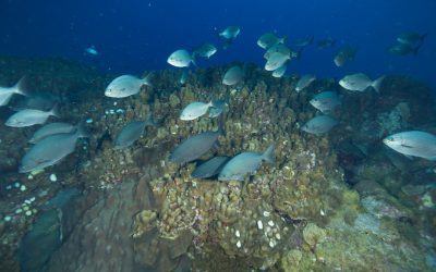
The Earth’s surface is divided into five major oceans: the Pacific, Atlantic, Indian, Southern (or Antarctic), and Arctic Oceans. These vast bodies of water play a crucial role in regulating the Earth’s climate and supporting diverse marine ecosystems. The oceans also serve as important transportation routes and a source of food and other natural resources for human societies around the world.
In addition to the oceans, the Earth’s landmasses are divided into seven continents: Africa, Antarctica, Asia, Europe, North America, Australia (or Oceania), and South America. Each continent has its own unique physical and cultural characteristics, shaped by millions of years of geological processes and human history. From the deserts of Africa to the rainforests of South America, the continents offer a rich tapestry of landscapes and environments for exploration and study.
Major Mountain Ranges and Deserts
The Earth’s surface is also marked by major mountain ranges and deserts that have shaped the planet’s physical and cultural landscapes. The Himalayas, for example, are the highest mountain range in the world and are home to diverse ecosystems and cultures in countries such as India, Nepal, and Bhutan. The Andes in South America, the Rockies in North America, and the Alps in Europe are other prominent mountain ranges that have influenced human settlement patterns and economic activities.
Deserts cover about one-third of the Earth’s land surface and are characterized by low precipitation and extreme temperatures. The Sahara Desert in Africa is the largest hot desert in the world, while the Gobi Desert in Asia is one of the largest cold deserts. Deserts are not only home to unique flora and fauna but have also been important trade routes and cultural crossroads throughout history.
Climate Zones and Biomes
The Earth’s climate is influenced by a variety of factors, including latitude, altitude, ocean currents, and prevailing winds. As a result, the planet is divided into different climate zones, each with its own characteristic weather patterns and ecosystems. The equator, for example, experiences a tropical climate with high temperatures and heavy rainfall, while the polar regions have a cold and dry climate.
These climate zones give rise to different biomes, or large ecological areas characterized by distinct plant and animal communities. The tropical rainforest biome, found near the equator, is home to a diverse array of species and is vital for regulating the Earth’s climate. The grasslands biome, found in regions such as the African savannah and North American prairies, supports grazing animals and has been important for human agriculture throughout history.
Human Geography and Population Distribution
Human geography examines the ways in which people and their activities are distributed across the Earth’s surface. It encompasses topics such as population growth, migration patterns, urbanization, and cultural diversity. Understanding human geography is crucial for addressing global challenges such as poverty, inequality, and environmental degradation.
Population distribution is uneven across the world, with some regions experiencing rapid population growth while others are declining. The majority of the world’s population lives in Asia, particularly in countries such as China and India. Urban areas are also growing rapidly, with more than half of the world’s population now living in cities. This trend has significant implications for infrastructure development, resource management, and social inequality.
Historical and Cultural Geography
Historical geography examines how human activities have shaped the Earth’s landscapes over time. It explores topics such as colonialism, trade routes, and the rise and fall of empires. Cultural geography focuses on how human cultures have developed in different regions of the world and how they interact with their environments.
The Silk Road, for example, was an ancient trade route that connected China with Europe and facilitated the exchange of goods, ideas, and technologies across Eurasia. This historical trade route had a profound impact on the development of cultures and economies along its path. Similarly, cultural geographers study how different societies have adapted to their environments through practices such as agriculture, architecture, and religious beliefs.
The Importance of Geographic Knowledge
Geographic knowledge is crucial for addressing global challenges such as climate change, resource management, and international development. By understanding world geography, we can better appreciate the environmental, cultural, and economic challenges facing different regions of the world. This knowledge is crucial for addressing global issues such as climate change, resource management, and international development.
Geographic knowledge also helps us to understand our interconnectedness with other regions of the world. By studying world geography, we can gain a deeper appreciation for the diversity of our planet and the interconnectedness of its various regions. This understanding can foster a sense of global citizenship and empathy for people from different cultures and backgrounds.
In conclusion, world geography is a complex and multifaceted field that encompasses both physical and human aspects of the Earth’s landscapes. By studying world geography, we can gain a deeper appreciation for the diversity of our planet and the interconnectedness of its various regions. This knowledge is crucial for addressing global challenges such as climate change, resource management, and international development. It also helps us to understand our interconnectedness with other regions of the world and fosters a sense of global citizenship.
FAQs
What is world geography?
World geography is the study of the Earth’s landscapes, environments, and the relationships between people and their environments. It encompasses the physical features of the Earth, as well as the human activity that takes place on it.
Why is world geography important?
World geography is important because it helps us understand the world around us. It provides insights into the physical and human processes that shape our planet, and helps us make informed decisions about how to interact with our environment.
What are the main branches of world geography?
The main branches of world geography include physical geography, which focuses on the Earth’s natural features and processes, and human geography, which examines the relationships between people and their environments.
How does world geography impact our daily lives?
World geography impacts our daily lives in numerous ways, from influencing the weather and climate we experience, to shaping the availability of natural resources and influencing the distribution of populations and cultures around the world.
What are some key concepts in world geography?
Key concepts in world geography include location, place, human-environment interaction, movement, and region. These concepts help geographers understand and interpret the world around them.

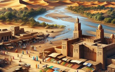
History of Mali
The ancient Mali Empire, situated in West Africa, emerged as a formidable power in the 13th century. Its founder, Sundiata Keita, renowned for his courage and leadership, is often referred to as the ‘Lion King’. Sundiata Keita’s ascension to power heralded Mali‘s golden age, during which he expanded the empire’s territories and established a robust central government. Under his reign, Mali flourished, becoming renowned for its affluence, cultural richness, and advanced societal structures. The Mali Empire’s rise was significantly influenced by its strategic position along the Niger River, which facilitated access to trade routes and bolstered economic growth. The empire’s prosperity was built upon the trade of gold, salt, and other valuable commodities, which were highly sought after in the region. Mali’s dominance over these trade routes enabled it to accumulate substantial wealth and establish itself as a dominant force in West Africa. Furthermore, the empire’s adoption of Islam strengthened its connections with the broader Islamic world, fostering cultural exchange and trade with other Muslim societies. The ascendancy of the Mali Empire can be attributed to strong leadership, strategic geographical location, and a thriving economy, factors which contributed to its status as one of Africa’s most powerful empires during its era. Summary Ancient Mali rose to power through the leadership of Sundiata Keita and the establishment of a strong empire in the 13th century. The Mali Empire reached its peak during the reign of Mansa Musa, known for his wealth and pilgrimage to Mecca, bringing prosperity and cultural exchange. Internal power struggles and external threats from neighbouring empires led to the decline of Mali in the 15th century. European...

Natural Resources of Mali: Where Natural Resources are Located in Mali
Mali, situated in West Africa, is a nation abundant in natural resources. From mining and minerals to agricultural and water resources, Mali possesses a diverse array of natural assets that contribute to its economy and the livelihoods of its citizens. The country’s natural resources play a crucial role in its development and sustainability, making it imperative to comprehend and manage them effectively. This article shall explore the various natural resources in Mali, their significance, and the endeavours being made to conserve and sustainably utilise them for the benefit of the country and its people. Mali’s natural resources are a wellspring of wealth and opportunity for the nation. With a land area exceeding 1.2 million square kilometres, Mali is endowed with a variety of natural resources that have the potential to drive economic growth and development. From gold and other minerals to fertile agricultural land, water bodies, and energy sources, Mali’s natural resources are diverse and plentiful. However, the sustainable management and conservation of these resources are essential to ensure their long-term availability and benefits for future generations. This article shall delve into the different natural resources in Mali, their current status, and the measures being taken to ensure their sustainable use and conservation. Summary Mali is rich in natural resources, including minerals, agricultural land, water, energy, and forests. The mining sector in Mali is a significant contributor to the country’s economy, with gold being the primary mineral of interest. Agriculture is a vital part of Mali’s economy, with the majority of the population relying on it for their livelihood. Mali has abundant water resources, with the Niger River being...

Cultural or Historical Sites of Mali: Important Cultural Landmarks or Historical Sites in Mali
Mali, situated in West Africa, is a nation abundant in cultural and historical heritage. From ancient cliff dwellings to magnificent mosques, Mali‘s cultural and historical sites provide a glimpse into the country’s diverse and vibrant past. These sites not only showcase Mali’s architectural and artistic achievements but also offer insight into the country’s intellectual and spiritual traditions. Visitors to Mali have the opportunity to explore these sites and gain a deeper understanding of the nation’s rich cultural heritage. Mali’s cultural and historical sites are of importance not only for the country’s identity but also for the world at large. Many of these sites have been recognised by UNESCO as World Heritage Sites, highlighting their significance on a global scale. From the Great Mosque of Djenné to the Timbuktu Manuscripts, these sites are not only a source of pride for Mali but also contribute to the world’s cultural diversity. This article will explore some of Mali’s most significant cultural and historical sites, examining their history, significance, and the experiences they offer to visitors. Summary Mali is home to a rich cultural and historical heritage, with numerous sites that showcase the country’s diverse traditions and intellectual achievements. The Great Mosque of Djenné is a stunning example of Sahelian architecture and a UNESCO World Heritage Site, attracting visitors from around the world. The Timbuktu Manuscripts are a valuable collection of ancient texts that provide insight into Mali’s intellectual and scholarly history, and efforts are underway to preserve and protect them. The Dogon Country is a must-visit for those interested in exploring Mali’s ancient cliff dwellings and learning about the unique culture and...

Population Density of Mali
Mali, a landlocked country in West Africa, is renowned for its rich cultural heritage and diverse landscapes. With a total area of over 1.2 million square kilometres, Mali is the eighth-largest country in Africa. Despite its vast size, Mali has a relatively low population density, with an estimated population of approximately 20 million people. This translates to an average of 16 people per square kilometre, making Mali one of the least densely populated countries in the world. However, this low population density is not evenly distributed across the country, with some regions being more densely populated than others. Understanding the factors that affect population distribution in Mali is crucial for addressing the challenges and opportunities that arise from varying population densities. Summary Mali’s population density is unevenly distributed, with the majority of people living in the southern regions and along the Niger River. Factors affecting population distribution in Mali include climate, natural resources, and historical settlement patterns. Urban population density in Mali is increasing due to rural-urban migration, while rural areas remain sparsely populated. High population density in Mali puts pressure on infrastructure and resources, leading to challenges in providing basic services and maintaining environmental sustainability. Government policies and initiatives in Mali aim to manage population density through urban planning, resource management, and rural development programs. Factors Affecting Population Distribution in Mali Geographical Factors Several factors contribute to the uneven distribution of population in Mali. One of the primary factors is the country’s diverse geography, which includes arid deserts in the north, fertile plains in the south, and the Niger River basin running through the central region. The availability...
Mali Country Profile: The Mali Empire, Map, History, and Profile of the West Africa Empire
Mali (République du Mali (Republic of Mali)) Capital: Bamako Population (Estimated July 2012): 14,533,511 Area: 1,248,574 km2 or 482,077 mi2 Currency: CFA Franc (CFAF) Official Language: French Political Information: Semi-Presidential Republic Official Religion: No Official Religion (approximately 90% of the population are Muslim, 9% follow Indigenous beliefs and 1% are Christian) Highest Mountain: Hombori Tondo at 1,155m or 3789ft GDP Official Exchange Rate (OER is more precise at gauging a country’s economic power) (Estimated 2011): $11 billion (US$) or (GBP) GDP (OER) Per Capita (per member of the population estimated 2011): (US$) or (GBP) GDP Purchasing Power Parity (PPP is good for gauging living conditions and the use of resources but not as accurate as OER. This data has been calculated based on the sum value of all goods and services produced in the country valued at prices prevailing in the United States) (Estimated 2011): $18.26 billion (US$) or (GBP) GDP (PPP) Per Capita (per member of the population estimated 2011): $1,300 (US$) or (GBP) Time Zone (GMT/UTC): GMT Wildlife: Counties/Provinces/States: 8 regions (regions, singular – region), 1 district*; District de Bamako*, Gao, Kayes, Kidal, Koulikoro, Mopti, Segou, Sikasso, Tombouctou (Timbuktu) Leaders: President Amadou Toumani Touré with Prime Minister Cissé Mariam Kaïdama Sidibé Additional: Gained independence from France on the 22nd of September 1960. Sources: CIA World Fact Book, Encyclopaedia Britannica. Mali and the Mighty Empire of West Africa: A Deep Dive into the Mali Country Profile and History Mali — a land steeped in history, from the golden age of the Mali Empire to the modern-day Republic of Mali — stands as a fascinating study of resilience, culture, and geopolitics in West Africa. Once a mighty empire renowned for its wealth...

Political Boundaries of Maldives: Provinces, Districts, or Historical Boundaries.
The Maldives, an archipelago situated in the Indian Ocean, is a sovereign state with a distinctive political boundary structure. The country comprises 26 atolls, which are further subdivided into administrative divisions known as provinces and districts. The political boundaries of the Maldives play a crucial role in the governance and administration of the country, as they determine the allocation of resources, implementation of policies and provision of public services. Understanding the intricacies of these boundaries is essential for comprehending the political landscape of the Maldives and the challenges it faces in maintaining effective governance. The political boundaries of the Maldives have evolved over time, influenced by historical, geographical and administrative factors. The country’s unique geography, with its scattered islands and atolls, presents a complex challenge in terms of governance and administration. As such, the political boundaries have been designed to address these challenges and ensure effective governance across the archipelago. This article will explore the structure and function of provinces and districts in the Maldives, examine the historical boundaries and their significance, and discuss the potential changes and developments in the future of the country’s political boundaries. Summary The political boundaries of Maldives are defined by its 26 atolls, which are further divided into administrative divisions. Maldives is divided into 20 administrative provinces, each with its own council responsible for local governance and development. The districts in Maldives are organized under the provinces and are responsible for local administration and service delivery. The historical boundaries of Maldives have been influenced by colonial powers and have significant cultural and political significance. Comparing provinces, districts, and historical boundaries in Maldives provides...
Climate Zones Of Maldives: Different climate regions Of Maldives
The Maldives, an archipelagic nation situated in the Indian Ocean, exhibits diverse climate zones owing to its geographical position and topography. The country’s climate is predominantly influenced by monsoon winds and the surrounding ocean, resulting in distinct climatic regions across the islands. The Maldives‘ climate can be broadly classified into equatorial, tropical monsoon, semi-arid, and subtropical zones. Each of these climate zones possesses a unique set of characteristics that significantly impact the environment, flora and fauna, and tourism industry of the Maldives. A comprehensive understanding of these varied climate zones is crucial for both residents and visitors to adequately prepare for the prevailing weather conditions and to fully appreciate the natural diversity of the archipelago. Summary The Maldives has a diverse range of climate zones, including equatorial, tropical monsoon, semi-arid, and subtropical. The equatorial climate zone in the Maldives is characterized by high temperatures, heavy rainfall, and high humidity throughout the year. The tropical monsoon climate zone experiences distinct wet and dry seasons, with heavy rainfall and strong winds during the wet season. The semi-arid climate zone in the Maldives has low rainfall and high temperatures, leading to dry and arid conditions. The subtropical climate zone is characterized by mild temperatures and moderate rainfall, creating a more temperate climate compared to other zones in the Maldives. Equatorial Climate Zone Climate Characteristics The equatorial climate zone in the Maldives is typified by high temperatures, heavy rainfall, and consistent humidity throughout the year. This climate zone is influenced by the Intertropical Convergence Zone (ITCZ), which brings warm, moist air to the region. The equatorial climate zone experiences minimal temperature variations, with...
Terrain and Topography of Maldives: mountains, valleys, and plains.
The Maldives, an archipelago situated in the Indian Ocean, is renowned for its exceptional natural splendour and distinctive topography. Comprising 26 atolls and over 1,000 coral islands, the Maldives is a low-lying nation with an average ground level of merely 1.5 metres above sea level, rendering it the lowest country on Earth. The terrain of the Maldives is characterised by its flat and sandy landscape, with the highest point in the country reaching a mere 2.4 metres above sea level. The topography of the Maldives is largely influenced by its geological formation as a result of coral reef growth and the subsequent submergence of volcanic islands. This has resulted in a unique and diverse landscape that is unparalleled worldwide. The Maldives’ topography is also heavily influenced by its location within the Indian Ocean, which has shaped its climate and weather patterns. The country experiences a tropical monsoon climate, with distinct wet and dry seasons. The topography of the Maldives plays a crucial role in shaping its ecosystems, including its coral reefs, mangrove forests, and lagoons, which are vital to the country’s biodiversity and marine life. The unique terrain and topography of the Maldives have also had a significant impact on the culture and society of the country, influencing everything from traditional architecture to livelihoods and cultural practices. Summary The Maldives is an archipelago consisting of 26 atolls and over 1,000 coral islands, with a terrain primarily made up of low-lying islands and coral reefs. Unlike many other countries, the Maldives is devoid of mountains, with the highest point being only 2.4 meters above sea level. The unique topography of...
History of Maldives
Malaysia possesses a rich and diverse history dating back to ancient times. The early settlement of the Malay Peninsula can be traced to the 1st century AD, with evidence of trade and cultural exchange with the Indian subcontinent. The Malay Peninsula’s strategic location for trade attracted various ethnic groups, including the Malays, Chinese and Indians. Early Malay kingdoms, such as Langkasuka and Srivijaya, played a significant role in shaping the cultural and political landscape of the region. The colonisation of Malaysia began in the 15th century when the Portuguese arrived in Malacca in 1511. They established a strong presence in the region and exerted their influence over the local population. However, their rule was short-lived, as the Dutch ousted them in 1641. The Dutch East India Company, known as the VOC, took control of Malacca and expanded their influence to other parts of the Malay Peninsula. Dutch colonisation brought about significant changes in the region, including the introduction of new agricultural practices and the establishment of trading posts. Summary Early settlement and colonization in the Maldives dates back to ancient times, with influences from various cultures such as Indian, Sri Lankan, and Arab. Islamic influence and the establishment of the Sultanate in the 12th century shaped the cultural and religious identity of the Maldives. Portuguese and Dutch occupation in the 16th and 17th centuries brought significant changes to the Maldives, including the introduction of Christianity and the decline of the Sultanate. The Maldives became a British protectorate in the 19th century and gained independence in 1965, marking a new era in its political history. Modern political history in the...
Natural Resources of Maldives: Where Natural Resources are located In Maldives
The Maldives, an archipelago comprising 26 atolls in the Indian Ocean, is renowned for its exceptional natural beauty and rich biodiversity. The nation’s natural resources play a vital role in supporting its economy and providing livelihoods for its inhabitants. The Maldives possesses an abundance of natural resources, including fisheries, marine resources, coral reefs, renewable energy sources, mineral resources and agricultural resources. These assets are essential for the sustenance of the Maldivian people and serve as a significant attraction for international tourists. However, the sustainable management and conservation of these natural resources are crucial to ensure their long-term viability and to safeguard the delicate ecosystem of the Maldives. The Maldives is heavily dependent on its natural resources, particularly its fisheries and marine resources, which have been the foundation of the country’s economy for centuries. The nation’s unique geographical location and rich marine biodiversity make it an ideal fishing destination. The Maldives is renowned for its tuna fisheries, which have been a primary source of income for the local population. In recent years, the government has undertaken efforts to modernise the fishing industry and promote sustainable fishing practices to ensure the long-term viability of this vital resource. Furthermore, the country’s marine resources, including its vibrant coral reefs and diverse marine life, are a major attraction for tourists, contributing significantly to the nation’s economy. However, the increasing pressures of overfishing and climate change pose substantial threats to the sustainability of these resources, rendering conservation efforts all the more crucial. Summary Maldives is a small island nation with limited natural resources, making sustainable management crucial for its survival. Fisheries and marine resources play...
Cultural or Historical Sites of Maldives: Important Cultural Landmarks or Historical Sites in Maldives
The Maldives, an archipelago comprising 26 atolls in the Indian Ocean, is renowned for its exceptional natural beauty, unspoilt beaches and opulent resorts. Beyond its picturesque landscapes, the Maldives possesses a rich cultural and historical heritage spanning millennia. The nation’s history is a complex tapestry interwoven with influences from diverse cultures, religions and traditions, rendering it a captivating destination for those keen to explore the convergence of history, culture and religion. The Maldives’ extensive and intricate history has moulded its distinctive cultural identity. From ancient Buddhist temples to Islamic architecture, the country’s heritage reflects the myriad influences that have shaped its evolution over the centuries. Consequently, the Maldives is home to a wealth of historical sites, artefacts and traditions that provide insight into its rich and vibrant past. This article shall examine the cultural and historical significance of the Maldives, exploring its ancient Buddhist temples, Islamic influence, national museum, traditional dance and music, and efforts to preserve its cultural heritage. Summary The Maldives is a culturally rich country with a deep historical significance, influenced by both Buddhism and Islam. The ancient Buddhist temples in the Maldives offer a glimpse into the island’s rich religious heritage, with intricate carvings and historical significance. Islam has had a profound impact on Maldivian culture and architecture, shaping the country’s traditions and way of life. The Maldivian National Museum is a treasure trove of artifacts and historical items, showcasing the country’s rich cultural heritage. The Hukuru Miskiy is the oldest mosque in the Maldives, offering a fascinating insight into the country’s Islamic history and architecture. The Ancient Buddhist Temples of Maldives: Exploring the Island’s...
Population Density of Maldives
The Maldives, a tropical archipelago situated in the Indian Ocean, comprises 26 atolls and more than 1,000 coral islands. Renowned for its pristine waters, alabaster beaches and diverse marine ecosystems, the Maldives attracts numerous tourists and is famed for its opulent resorts and overwater accommodations. Malé, the capital city, holds the distinction of being the world’s most densely populated urban centre, with over 50,000 inhabitants occupying a mere 5.7 square kilometres. The nation’s total population stands at approximately 530,000, rendering it one of the most densely populated countries globally. The Maldives’ population density is roughly 1,188 persons per square kilometre, substantially exceeding the worldwide average. This high concentration of inhabitants in the Maldives engenders both difficulties and prospects for the nation, influencing various facets of life, including environmental concerns, infrastructure development and economic growth. Summary The Maldives is an island nation in the Indian Ocean known for its stunning beaches, coral reefs, and luxury resorts. Factors contributing to the high population density in the Maldives include limited land availability, urbanization, and economic opportunities in the capital city of Male. High population density in the Maldives has led to environmental challenges such as waste management, water scarcity, and pressure on natural resources. Challenges of high population density in the Maldives include strain on infrastructure, limited access to healthcare and education, but also opportunities for economic growth and innovation. Population density varies across different regions of the Maldives, with the capital city of Male being the most densely populated area. Factors contributing to the population density Geographical Constraints The limited land area of the Maldives, comprising small, low-lying islands, restricts the...