Tanzania, located in East Africa, is a nation renowned for its diverse and striking landscapes. The country boasts a rich tapestry of terrain that ranges from coastal beaches to towering mountains, expansive plateaus, and lush valleys. This geographical diversity is not merely a backdrop; it plays a crucial role in shaping the climate, ecosystems, and human activities within the region.
The interplay of these various landforms creates a unique environment that supports an array of flora and fauna, making Tanzania one of the most biodiverse countries in the world. The topography of Tanzania is characterised by its dramatic contrasts. The Great Rift Valley slices through the country, creating a series of lakes and valleys that are home to unique wildlife and plant species.
To the north, Mount Kilimanjaro rises majestically, its snow-capped peak visible for miles around, while the southern regions are dominated by the vast Selous Game Reserve and the rugged terrain of the Udzungwa Mountains. This article delves into the various aspects of Tanzania’s terrain and topography, exploring how these features influence both the natural world and human life.
Summary
- Tanzania’s terrain and topography are incredibly diverse, ranging from high mountains to vast plains and stunning lakes and valleys.
- The Great Rift Valley is a remarkable geological feature that runs through Tanzania, offering breathtaking landscapes and unique ecosystems.
- The highlands and mountains of Tanzania, including Mount Kilimanjaro, provide habitat for a wide variety of wildlife and offer incredible trekking opportunities.
- The vast plains and plateaus of Tanzania are home to iconic African wildlife such as lions, elephants, and wildebeest, making them a popular destination for safari enthusiasts.
- The great lakes and valleys of Tanzania, including Lake Victoria and the Ngorongoro Crater, are vital for supporting diverse ecosystems and wildlife.
The Great Rift Valley: A Spectacular Geological Feature
The Great Rift Valley is one of the most significant geological features in Tanzania, stretching from the Middle East down through East Africa. This immense rift system is a result of tectonic plate movements that have shaped the landscape over millions of years. In Tanzania, the rift valley is marked by a series of lakes, including Lake Tanganyika, Lake Nyasa, and Lake Manyara, each with its own unique ecological characteristics.
These lakes are not only vital water sources but also support diverse ecosystems that attract numerous species of birds, fish, and other wildlife. The geological activity associated with the Great Rift Valley has also led to the formation of numerous hot springs and volcanic craters, such as Ol Doinyo Lengai, an active volcano known for its unique carbonatite lava. The presence of these geological features has created a rich environment for scientific research and exploration.
The rift valley’s varied topography provides habitats for endemic species, making it a hotspot for biodiversity. For instance, the alkaline waters of Lake Natron are home to flamingos that thrive in its harsh conditions, showcasing how life can adapt to extreme environments.
The Highlands and Mountains of Tanzania

Tanzania’s highlands are characterised by their rugged terrain and dramatic elevation changes. The most prominent feature is Mount Kilimanjaro, Africa’s highest peak at 5,895 metres above sea level. This iconic mountain attracts climbers from around the globe who seek to conquer its challenging routes while experiencing its diverse climatic zones, ranging from tropical rainforest at its base to arctic conditions at its summit.
The mountain’s glaciers and ice fields are not only breathtaking but also serve as critical water sources for surrounding communities. In addition to Kilimanjaro, the Eastern Arc Mountains are another significant highland region in Tanzania.
The Udzungwa Mountains, part of this range, are particularly notable for their unique ecosystems that include montane forests and grasslands. Conservation efforts in these areas are crucial as they face threats from deforestation and climate change. The highlands not only provide stunning landscapes but also play a vital role in regulating local climates and supporting agriculture in the surrounding lowlands.
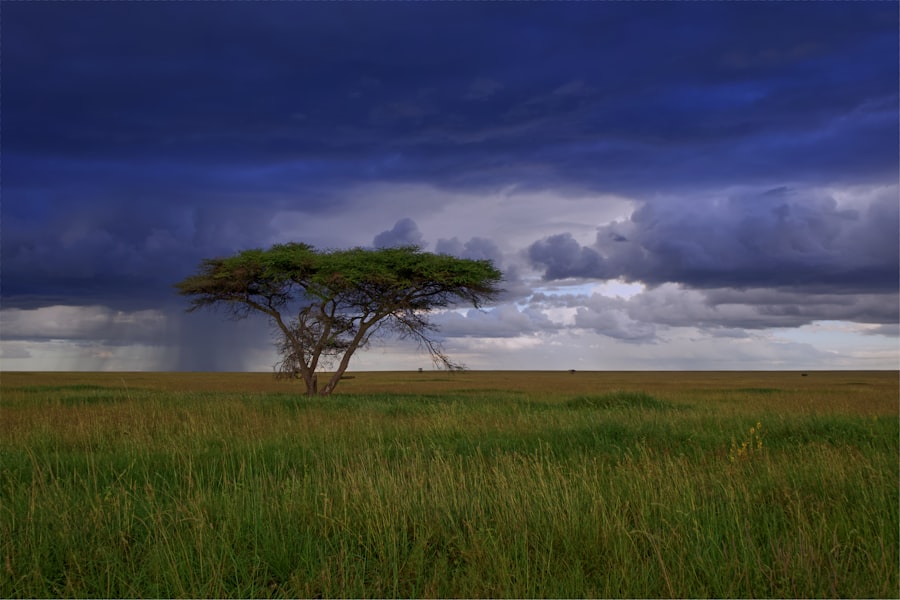
The Vast Plains and Plateaus of Tanzania
The vast plains and plateaus of Tanzania are integral to the country’s agricultural economy and wildlife conservation efforts.
The park’s expansive grasslands provide ideal grazing conditions for herbivores, which in turn support a diverse array of predators such as lions, cheetahs, and hyenas.
This intricate food web highlights the importance of maintaining these ecosystems for both wildlife conservation and tourism. Beyond the Serengeti lies the Central Plateau, which is characterised by its rolling hills and fertile soils. This region is crucial for agriculture, with crops such as maize, millet, and sunflowers being cultivated extensively.
The plateau’s elevation helps moderate temperatures, making it suitable for farming despite Tanzania’s overall tropical climate. However, agricultural practices must be managed sustainably to prevent soil degradation and ensure long-term productivity. The balance between conservation and agricultural development is a pressing issue in these areas as human populations continue to grow.
The Great Lakes and Valleys of Tanzania
Tanzania is home to several significant lakes that contribute to its ecological diversity and economic activities. Lake Tanganyika, one of the largest freshwater lakes in the world, is situated along the western border of Tanzania and is known for its deep waters and unique biodiversity. It harbours numerous endemic fish species, making it a vital resource for local fishing communities.
The lake’s surrounding valleys are rich in minerals and support agriculture, but they also face challenges such as overfishing and pollution. Lake Victoria, another major water body shared with Uganda and Kenya, plays a crucial role in the livelihoods of millions of people living in its basin. The lake supports extensive fishing industries but has been severely impacted by invasive species like the Nile perch, which have disrupted local ecosystems.
Efforts to manage these challenges are essential to preserve both the lake’s biodiversity and the economic activities that depend on it. The valleys surrounding these lakes are often fertile and support agriculture; however, they are also vulnerable to environmental degradation due to population pressures.
The Coastal and Island Terrain of Tanzania
Tanzania’s coastline along the Indian Ocean is characterised by stunning beaches, coral reefs, and islands that contribute to its rich cultural heritage and biodiversity. The Zanzibar Archipelago is perhaps the most famous of these islands, known for its historical significance as a trading hub and its vibrant culture. The islands boast beautiful beaches lined with palm trees and crystal-clear waters that attract tourists seeking relaxation as well as adventure activities such as diving and snorkelling.
The coastal region is also home to important marine ecosystems, including mangroves and coral reefs that provide habitats for numerous marine species. These ecosystems are vital for maintaining biodiversity and supporting local fisheries. However, they face threats from climate change, overfishing, and coastal development.
Conservation initiatives aimed at protecting these fragile environments are crucial not only for preserving marine life but also for sustaining the livelihoods of coastal communities that rely on these resources.
Impact of Terrain and Topography on Wildlife and Ecosystems
The diverse terrain and topography of Tanzania have a profound impact on its wildlife and ecosystems. Each geographical feature—from mountains to plains—provides distinct habitats that support various species adapted to specific environmental conditions. For instance, the montane forests of Kilimanjaro are home to unique bird species such as the Kilimanjaro white-eye, while the savannahs of the Serengeti support large herbivores like elephants and giraffes.
The interplay between different ecosystems creates a mosaic of habitats that enhances biodiversity. Seasonal migrations driven by climatic changes lead animals to traverse vast distances in search of food and water. This dynamic movement not only sustains populations but also facilitates genetic exchange among species.
However, human activities such as agriculture, urbanisation, and poaching pose significant threats to these ecosystems. Conservation efforts must focus on protecting critical habitats while promoting sustainable practices that allow both wildlife and human communities to thrive.
Human Interaction with Tanzania’s Diverse Terrain and Topography
Human interaction with Tanzania’s varied terrain has been shaped by cultural practices, economic activities, and environmental challenges. Traditional agricultural practices have evolved alongside the country’s topography; communities have adapted their farming techniques to suit different landscapes—from terracing on steep slopes to utilising floodplains for rice cultivation. These practices reflect a deep understanding of local ecosystems but are increasingly challenged by modern pressures such as population growth and climate change.
Tourism has emerged as a significant economic driver in Tanzania, largely due to its stunning landscapes and rich wildlife heritage. National parks like Serengeti and Ngorongoro Crater attract millions of visitors each year, providing vital revenue for conservation efforts while also presenting challenges related to environmental sustainability. Balancing tourism development with conservation goals requires careful planning to ensure that natural resources are preserved for future generations while still benefiting local communities economically.
In conclusion, Tanzania’s terrain and topography present a complex interplay between natural features and human activities. Understanding this relationship is essential for fostering sustainable development that respects both ecological integrity and cultural heritage.
FAQs
What is the terrain and topography of Tanzania like?
Tanzania’s terrain and topography consist of a diverse range of landscapes, including mountains, valleys, and plains. The country is home to Africa’s highest peak, Mount Kilimanjaro, as well as the Great Rift Valley and the vast Serengeti plains.
What are the major mountains in Tanzania?
Tanzania is known for its prominent mountain ranges, with Mount Kilimanjaro being the most famous. Other significant mountains in Tanzania include Mount Meru, the Usambara Mountains, and the Livingstone Mountains.
What valleys are found in Tanzania?
Tanzania is home to the Great Rift Valley, which runs through the eastern part of the country. This valley is known for its stunning landscapes and diverse ecosystems, including lakes, forests, and grasslands.
What are the main plains in Tanzania?
The Serengeti plains are one of the most well-known features of Tanzania’s topography. These vast grasslands are home to a rich variety of wildlife and are famous for the annual wildebeest migration. Other plains in Tanzania include the Maasai Steppe and the coastal plains along the Indian Ocean.


