World Geography
Geography is the study of the Earth’s landscapes, environments, and the relationships between people and their surroundings. It encompasses both the physical aspects of the Earth, such as its landforms, bodies of water, and climate, as well as the human aspects, including population distribution, cultures, and economies. World geography is a broad field that seeks to understand the complexities of our planet and how humans interact with it. By studying world geography, we can gain a deeper appreciation for the diversity of our planet and the interconnectedness of its various regions.
Geography is a multidisciplinary field that draws on elements of physical science, social science, and humanities. It involves the use of maps, spatial analysis, and geographic information systems (GIS) to understand the Earth’s surface and the processes that shape it. World geography also encompasses the study of human geography, which examines the ways in which people and their activities are distributed across the Earth. By understanding world geography, we can better appreciate the environmental, cultural, and economic challenges facing different regions of the world. This knowledge is crucial for addressing global issues such as climate change, resource management, and international development.
The Five Oceans and Seven Continents
The Earth’s surface is divided into five major oceans: the Pacific, Atlantic, Indian, Southern (or Antarctic), and Arctic Oceans. These vast bodies of water play a crucial role in regulating the Earth’s climate and supporting diverse marine ecosystems. The oceans also serve as important transportation routes and a source of food and other natural resources for human societies around the world.
In addition to the oceans, the Earth’s landmasses are divided into seven continents: Africa, Antarctica, Asia, Europe, North America, Australia (or Oceania), and South America. Each continent has its own unique physical and cultural characteristics, shaped by millions of years of geological processes and human history. From the deserts of Africa to the rainforests of South America, the continents offer a rich tapestry of landscapes and environments for exploration and study.
Major Mountain Ranges and Deserts
The Earth’s surface is also marked by major mountain ranges and deserts that have shaped the planet’s physical and cultural landscapes. The Himalayas, for example, are the highest mountain range in the world and are home to diverse ecosystems and cultures in countries such as India, Nepal, and Bhutan. The Andes in South America, the Rockies in North America, and the Alps in Europe are other prominent mountain ranges that have influenced human settlement patterns and economic activities.
Deserts cover about one-third of the Earth’s land surface and are characterized by low precipitation and extreme temperatures. The Sahara Desert in Africa is the largest hot desert in the world, while the Gobi Desert in Asia is one of the largest cold deserts. Deserts are not only home to unique flora and fauna but have also been important trade routes and cultural crossroads throughout history.
Climate Zones and Biomes
The Earth’s climate is influenced by a variety of factors, including latitude, altitude, ocean currents, and prevailing winds. As a result, the planet is divided into different climate zones, each with its own characteristic weather patterns and ecosystems. The equator, for example, experiences a tropical climate with high temperatures and heavy rainfall, while the polar regions have a cold and dry climate.
These climate zones give rise to different biomes, or large ecological areas characterized by distinct plant and animal communities. The tropical rainforest biome, found near the equator, is home to a diverse array of species and is vital for regulating the Earth’s climate. The grasslands biome, found in regions such as the African savannah and North American prairies, supports grazing animals and has been important for human agriculture throughout history.
Human Geography and Population Distribution
Human geography examines the ways in which people and their activities are distributed across the Earth’s surface. It encompasses topics such as population growth, migration patterns, urbanization, and cultural diversity. Understanding human geography is crucial for addressing global challenges such as poverty, inequality, and environmental degradation.
Population distribution is uneven across the world, with some regions experiencing rapid population growth while others are declining. The majority of the world’s population lives in Asia, particularly in countries such as China and India. Urban areas are also growing rapidly, with more than half of the world’s population now living in cities. This trend has significant implications for infrastructure development, resource management, and social inequality.
Historical and Cultural Geography
Historical geography examines how human activities have shaped the Earth’s landscapes over time. It explores topics such as colonialism, trade routes, and the rise and fall of empires. Cultural geography focuses on how human cultures have developed in different regions of the world and how they interact with their environments.
The Silk Road, for example, was an ancient trade route that connected China with Europe and facilitated the exchange of goods, ideas, and technologies across Eurasia. This historical trade route had a profound impact on the development of cultures and economies along its path. Similarly, cultural geographers study how different societies have adapted to their environments through practices such as agriculture, architecture, and religious beliefs.
The Importance of Geographic Knowledge
Geographic knowledge is crucial for addressing global challenges such as climate change, resource management, and international development. By understanding world geography, we can better appreciate the environmental, cultural, and economic challenges facing different regions of the world. This knowledge is crucial for addressing global issues such as climate change, resource management, and international development.
Geographic knowledge also helps us to understand our interconnectedness with other regions of the world. By studying world geography, we can gain a deeper appreciation for the diversity of our planet and the interconnectedness of its various regions. This understanding can foster a sense of global citizenship and empathy for people from different cultures and backgrounds.
In conclusion, world geography is a complex and multifaceted field that encompasses both physical and human aspects of the Earth’s landscapes. By studying world geography, we can gain a deeper appreciation for the diversity of our planet and the interconnectedness of its various regions. This knowledge is crucial for addressing global challenges such as climate change, resource management, and international development. It also helps us to understand our interconnectedness with other regions of the world and fosters a sense of global citizenship.
FAQs
What is world geography?
World geography is the study of the Earth’s landscapes, environments, and the relationships between people and their environments. It encompasses the physical features of the Earth, as well as the human activity that takes place on it.
Why is world geography important?
World geography is important because it helps us understand the world around us. It provides insights into the physical and human processes that shape our planet, and helps us make informed decisions about how to interact with our environment.
What are the main branches of world geography?
The main branches of world geography include physical geography, which focuses on the Earth’s natural features and processes, and human geography, which examines the relationships between people and their environments.
How does world geography impact our daily lives?
World geography impacts our daily lives in numerous ways, from influencing the weather and climate we experience, to shaping the availability of natural resources and influencing the distribution of populations and cultures around the world.
What are some key concepts in world geography?
Key concepts in world geography include location, place, human-environment interaction, movement, and region. These concepts help geographers understand and interpret the world around them.
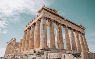
Cultural or Historical Sites of Greece: Important Cultural Landmarks or Historical Sites In Greece
The Acropolis of Athens is a symbol of ancient Greek civilization and is one of the most famous landmarks in the world. Perched high on a rocky outcrop overlooking the city of Athens, the Acropolis is a testament to the architectural and artistic achievements of the ancient Greeks. The most famous building on the Acropolis is the Parthenon, a temple dedicated to the goddess Athena, the patron deity of Athens. The Parthenon is a masterpiece of classical architecture, with its iconic columns and intricate friezes depicting scenes from Greek mythology. The Acropolis also includes several other ancient buildings, such as the Erechtheion and the Propylaea, which are equally impressive in their design and construction. The Acropolis has a long and storied history, having been inhabited since the Neolithic period. It was during the 5th century BC, known as the Golden Age of Athens, that the most famous buildings were constructed on the Acropolis. The Parthenon, in particular, is a symbol of the power and wealth of ancient Athens, and it continues to inspire awe and admiration to this day. The Acropolis has also been a site of religious significance, with temples and sanctuaries dedicated to various gods and goddesses. Today, the Acropolis is a UNESCO World Heritage Site and attracts millions of visitors from around the world who come to marvel at its ancient splendour and learn about the history of ancient Greece. Summary The Acropolis of Athens is a symbol of ancient Greek civilization, showcasing the architectural and artistic achievements of the Golden Age of Athens. Delphi was considered the centre of the ancient world and was home...
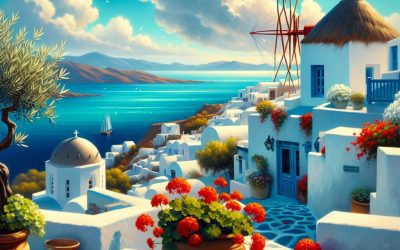
Greece
Greece (Ellinikí Dhimokratía (Hellenic Republic)) Capital: Pago Pago Population (Estimated July 2012): 68,061 Area: 200km2 or 77mi2 Currency: United States Dollar (U.S.$) Official Language: English; Samoan Political Information: Unincorporated and unorganized territory of the US Official Religion: No Official Religion (approximately 50% of the population is Christian Congregationalist, 20% are Roman Catholic and 30% are either protestant or have other religious beliefs) Highest Mountain: Lata Mountain at 964m or 3162 feet GDP Official Exchange Rate (OER is more precise at gauging a countries economic power) (Estimated 2005): $462.2 million (US$) or (GBP) GDP (OER) Per Capita (per member of the population estimated 2011): (US$) or (GBP) GDP Purchasing Power Parity (PPP is good for gauging living conditions and use of resources but not as accurate as OER. This data has been calculated based on the sum value of all goods and services produced in the country valued at prices prevailing in the United States) (Estimated 2007): $575.3 million (US$) or (GBP) GDP (PPP) Per Capita (per member of the population estimated 2007): $8,000 (US$) or (GBP) Time Zone (GMT/UTC): -11:00 Counties/Provinces/States: three districts and two islands at the second order; Eastern, Manu’a, Rose Island, Swains Island, Western Leaders: President Donald Trump; Governor Togiola Tulafono Sources: CIA World Fact Book, Encyclopaedia Britannica. Greece Greece, located in southeastern Europe, is a country known for its rich history, stunning landscapes, and vibrant culture. It is often referred to as the cradle of Western civilization, as it is the birthplace of democracy, philosophy, and the Olympic Games. The country is made up of a mainland and thousands of islands scattered throughout...

Political Boundaries of Ghana: Provinces, Districts, or Historical Boundaries.
Political boundaries in Ghana refer to the demarcation lines that separate different administrative units within the country. These boundaries are crucial for the governance and administration of the country, as they determine the allocation of resources, representation, and the implementation of policies and laws. Ghana is located in West Africa and is bordered by Côte d’Ivoire to the west, Burkina Faso to the north, Togo to the east, and the Gulf of Guinea to the south. The country is divided into administrative regions, districts, and local governance areas, each with its own set of boundaries and responsibilities. The political boundaries in Ghana have evolved over time, influenced by historical, cultural, and geographical factors. Understanding these boundaries is essential for comprehending the governance and development of the country. Ghana’s political boundaries play a significant role in shaping the country’s governance and development. The demarcation of administrative regions, districts, and local governance areas determines the allocation of resources, representation, and the implementation of policies and laws. These boundaries are essential for effective governance and administration, as they provide a framework for decision-making and resource allocation. Understanding the political boundaries in Ghana is crucial for comprehending the country’s governance structure and the challenges it faces. In this article, we will explore the provinces and administrative regions in Ghana, the historical boundaries of the country, as well as the impact of political boundaries on development and governance. We will also discuss the challenges and issues with political boundaries in Ghana and the future prospects for their evolution. Summary Ghana is a country in West Africa with a complex system of political boundaries. The...

History of Ghana
Ghana has a rich and diverse history that dates back to ancient times. The region that is now known as Ghana was once home to several powerful and influential kingdoms and empires. One of the most well-known of these ancient civilizations was the Ghana Empire, which flourished between the 9th and 13th centuries. The Ghana Empire was a major trading power in West Africa, known for its wealth and sophisticated governance. It controlled the trans-Saharan trade routes and was a hub for the exchange of gold, salt, and other valuable commodities. Another significant pre-colonial kingdom in the region was the Ashanti Empire, which rose to prominence in the 17th century. The Ashanti Empire was known for its strong military and political organization, as well as its rich cultural heritage. The empire’s economy was based on the trade of gold, ivory, and slaves, and it played a central role in the transatlantic slave trade. The Ashanti people were also known for their skilled craftsmanship, particularly in the production of gold jewelry and textiles. Overall, pre-colonial Ghana was a region of great cultural, economic, and political significance in West Africa. The ancient kingdoms and empires that thrived in this area left a lasting legacy that continues to shape Ghanaian society and identity to this day. Summary Pre-Colonial Ghana was home to ancient kingdoms and empires, including the Ashanti and the Akwamu, known for their rich cultural heritage and trade networks. The arrival of European explorers and traders in the 15th century marked the beginning of significant changes in Ghana, including the introduction of new goods and the establishment of forts and...

Climate Zones of Ghana: Different climate regions Of Ghana
Ghana is a country located in West Africa, known for its diverse climate zones. The country’s climate is influenced by its proximity to the equator, the presence of the Gulf of Guinea, and the elevation differences across the country. Ghana’s climate can be broadly categorized into six main zones: the tropical rainforest, tropical savannah, coastal, semi-arid, transitional, and highland climate zones. Each of these zones has its own unique characteristics, including temperature, precipitation, and vegetation. Understanding these climate zones is crucial for understanding the country’s biodiversity, agriculture, and overall environmental conditions. Summary Ghana has six main climate zones, each with its own unique characteristics and weather patterns. The Tropical Rainforest Climate Zone is characterized by high temperatures, heavy rainfall, and lush vegetation. The Tropical Savannah Climate Zone experiences a wet season and a dry season, with grasslands and scattered trees. The Coastal Climate Zone has high humidity, warm temperatures, and frequent rainfall due to its proximity to the ocean. The Semi-Arid Climate Zone has low rainfall and high temperatures, leading to dry and dusty conditions. The Transitional Climate Zone experiences a mix of characteristics from the other zones, with varying levels of rainfall and temperature. The Highland Climate Zone has cooler temperatures and lower humidity due to its higher elevation, with distinct wet and dry seasons. The Tropical Rainforest Climate Zone The tropical rainforest climate zone covers the southern part of Ghana, including the Ashanti and Western regions. This zone is characterized by high temperatures and abundant rainfall throughout the year. The average temperature in this zone ranges from 24°C to 28°C, with little variation between seasons. The annual...

Terrain and Topography of Ghana: mountains, valleys, and plains.
Ghana, located in West Africa, is a country with diverse and varied terrain and topography. The landscape of Ghana is characterized by a mix of mountains, valleys, lowlands, plains, and plateaus, making it a geographically rich and diverse country. The terrain and topography of Ghana play a significant role in shaping the country’s climate, human settlements, agriculture, and conservation efforts. Understanding the different geographical features of Ghana is crucial in appreciating the country’s natural beauty and the challenges it faces in managing its diverse landscapes. Ghana’s terrain and topography are influenced by the country’s location on the Gulf of Guinea and its proximity to the equator. The southern part of the country is characterized by low-lying coastal plains, while the central and northern regions are dominated by highlands, plateaus, and valleys. The Volta River, one of the largest rivers in West Africa, also cuts through the eastern part of the country, creating a unique landscape of river valleys and basins. The diverse terrain and topography of Ghana provide a rich tapestry of natural beauty and resources that have shaped the country’s history, culture, and development. Summary Ghana’s terrain and topography are diverse, ranging from mountains and valleys to plains and plateaus. The mountain ranges of Ghana include the Akwapim-Togo ranges and the Kwahu Plateau, offering stunning landscapes and biodiversity. The valleys and lowlands of Ghana, such as the Volta Basin and the Densu Basin, are important for agriculture and human settlements. The plains and plateaus of Ghana, including the Guinea Savannah and the Akan Lowlands, support a variety of agricultural activities. The varied terrain and topography of Ghana greatly...

Natural Resources of Ghana: Where Natural Resources are located In Ghana
Ghana is a country located in West Africa, known for its rich and diverse natural resources. The country is blessed with an abundance of gold, timber, oil, gas, minerals, agricultural land, water resources, and hydroelectric power. These natural resources have played a significant role in the economic development of the country and have contributed to its status as one of the leading economies in the region. The sustainable management and conservation of these resources are crucial for the future prosperity of Ghana and its people. Ghana’s natural resources have attracted significant foreign investment and have been a major source of revenue for the country. The government has implemented policies and regulations to ensure the sustainable use of these resources while also promoting environmental conservation. The responsible management of these resources is essential to ensure their availability for future generations and to protect the environment from degradation. In this article, we will explore the various natural resources of Ghana and the efforts being made to conserve and sustainably manage them for the benefit of the country and its people. Summary Ghana is rich in natural resources, including gold, minerals, timber, oil, gas, agriculture, water, and hydroelectric power. The country is one of the top gold producers in the world, with significant mineral deposits such as bauxite, manganese, and diamonds. Ghana’s timber and forest resources are important for the economy, but sustainable management is crucial to prevent deforestation and environmental degradation. Oil and gas reserves have been discovered off the coast of Ghana, contributing to the country’s economic growth and energy security. Agriculture is a major sector in Ghana, with resources...

Population Density of Ghana
Population density refers to the number of people living in a specific area, usually measured per square kilometre or square mile. It is an important demographic indicator that provides insights into the distribution of people within a country or region. In the case of Ghana, population density plays a crucial role in understanding the spatial distribution of its population and the associated implications for infrastructure, resources, and socio-economic development. Ghana, located in West Africa, has a population of over 30 million people, with a land area of approximately 238,535 square kilometres. The population density of Ghana is estimated to be around 130 people per square kilometre, making it one of the most densely populated countries in the region. Understanding the factors that affect population density in Ghana, the differences between urban and rural population density, and the impact of population density on infrastructure and resources is essential for policymakers, urban planners, and development practitioners to effectively manage and plan for sustainable development. Summary Population density refers to the number of people living in a specific area, usually measured in square kilometres. Factors affecting population density in Ghana include natural resources, economic opportunities, and infrastructure development. Urban areas in Ghana have higher population density compared to rural areas due to better access to resources and employment opportunities. High population density in Ghana puts pressure on infrastructure and resources, leading to challenges in providing basic services such as water, sanitation, and healthcare. Government policies and initiatives in Ghana aim to manage population density through urban planning, resource management, and rural development programs. Factors Affecting Population Density in Ghana Several factors contribute...

Cultural or Historical Sites of Ghana: Important Cultural Landmarks or Historical Sites In Ghana
Ghana, located in West Africa, is a country rich in cultural and historical heritage. From ancient kingdoms to colonial forts, Ghana’s landscape is dotted with sites that tell the story of its past. These sites not only serve as a reminder of Ghana’s history but also as a testament to the resilience and strength of its people. Visitors to Ghana have the opportunity to explore these cultural and historical sites, gaining a deeper understanding of the country’s complex and diverse heritage. Ghana’s cultural and historical sites are not only important for preserving the country’s past but also for educating future generations about the struggles and triumphs of its people. From the Cape Coast Castle, a symbol of Ghana’s dark history with the transatlantic slave trade, to the Ashanti Kingdom, which preserves the rich cultural heritage of the Ashanti people, each site offers a unique insight into Ghana’s past. These sites also play a crucial role in promoting tourism and economic development in the country, attracting visitors from around the world who are eager to learn about Ghana’s history and experience its vibrant culture. Summary Ghana is home to a wealth of cultural and historical sites that showcase its rich heritage and complex history. The Cape Coast Castle stands as a haunting reminder of Ghana’s involvement in the transatlantic slave trade, with its dark and harrowing past. The Ashanti Kingdom plays a crucial role in preserving Ghana’s cultural traditions and is a testament to the country’s rich heritage. The Larabanga Mosque reflects Ghana’s Islamic influence and serves as a symbol of the country’s religious diversity. The Kwame Nkrumah Mausoleum honours...

Ghana
Ghana (Republic of Ghana) Capital: Accra Population (Estimated July 2012): 25,241,998 Area: 238,533km2 or 92,098mi2 Currency: Ghana Cedi (GH¢) Official Language: English Political Information: Constitutional Presidential Republic Official Religion: No Official Religion (approximately 68.8% of the population are Christian, 15.9% are Muslim, 9.2% have other religious beliefs and 6.1% have no religious beliefs) Highest Mountain: Mount Afadjato at 885m or 2,904ft GDP Official Exchange Rate (OER is more precise at gauging a countries economic power) (Estimated 2011): $38.6 billion (US$) or (GBP) GDP (OER) Per Capita (per member of the population estimated 2011): (US$) or (GBP) GDP Purchasing Power Parity (PPP is good for gauging living conditions and use of resources but not as accurate as OER. This data has been calculated based on the sum value of all goods and services produced in the country valued at prices prevailing in the United States) (Estimated 2011): $74.77 billion (US$) or (GBP) GDP (PPP) Per Capita (per member of the population estimated 2011): $3,100 (US$) or (GBP) Time Zone (GMT/UTC): GMT Wildlife: Counties/Provinces/States: 10 Regions; Ashanti, Brong-Ahafo, Central, Eastern, Greater Accra, Northern, Upper East, Upper West, Volta, Western Leaders: President John Atta Mills with Vice President John Dramani Mahama. Additional: Gained Independence from the U.K. on the 6th of March 1957 Sources: CIA World Fact Book, Encyclopaedia Britannica. Ghana Ghana, located in West Africa, is a country known for its rich history, diverse culture, and vibrant economy. With a population of over 30 million people, Ghana is a melting pot of ethnicities, languages, and traditions. The capital city, Accra, is a bustling metropolis that serves as the economic and cultural hub of the country. Ghana gained independence from British colonial rule in...

Political Boundaries of Germany: Provinces, Districts, or Historical Boundaries.
Germany, located in the heart of Europe, is a country known for its rich history, diverse culture, and strong economy. The political boundaries of Germany play a crucial role in the governance and administration of the country. These boundaries are essential for the organization and management of the various administrative units within the country. From provinces to districts, each political boundary serves a specific purpose in the functioning of the German state. Understanding the intricacies of these boundaries is essential for comprehending the political landscape of Germany and its impact on the lives of its citizens. The political boundaries in Germany are not only a product of modern administrative needs but also have deep historical roots that reflect the country’s complex past. The provinces, districts, and historical boundaries of Germany all contribute to the unique identity and governance structure of the country. This article will delve into the various aspects of political boundaries in Germany, exploring their administrative, cultural, and geographical significance, as well as the challenges and controversies surrounding them. Additionally, we will discuss the potential changes and developments that may shape the future of political boundaries in Germany. Summary Germany is divided into 16 federal states, each with its own government and administrative structure. Provinces in Germany are known as “Länder” and have significant autonomy in areas such as education and law enforcement. Districts in Germany are smaller administrative units within the provinces, responsible for local governance and public services. Historical boundaries in Germany, such as the former East and West Germany divide, continue to influence cultural and political dynamics. The debate over the restructuring of political...

Natural Resources of Germany: Where Natural Resources are located In Germany
Germany is a country rich in natural resources, which have played a significant role in its economic development and industrial growth. The diverse range of natural resources in Germany includes mineral resources, agricultural resources, forest resources, water resources, and energy resources. These resources have been crucial in shaping the country’s economy and have contributed to its status as one of the leading industrial nations in the world. However, the sustainable management of these natural resources is essential to ensure their availability for future generations and to minimize the environmental impact of their exploitation. Germany’s natural resources have been a driving force behind its economic success, and the country has a long history of utilizing these resources for industrial and agricultural purposes. The sustainable management of these resources is crucial for the country’s future development and environmental protection. This article will explore the various natural resources in Germany and the importance of their sustainable management for the country’s continued prosperity. Summary Germany is rich in natural resources, including minerals, agriculture, forests, water, and energy sources. The country has a diverse range of mineral resources, including coal, lignite, potash, and salt, which are crucial for its industrial and economic development. Germany’s agricultural resources are vital for food production, with the country being a leading producer of wheat, barley, and sugar beets. The forest resources in Germany are well-managed, providing timber for various industries and contributing to the country’s biodiversity and ecosystem. Germany’s water resources are abundant, with the country’s rivers and lakes providing essential water supply for various purposes, including agriculture, industry, and domestic use. Mineral Resources in Germany Germany is...