World Geography
Geography is the study of the Earth’s landscapes, environments, and the relationships between people and their surroundings. It encompasses both the physical aspects of the Earth, such as its landforms, bodies of water, and climate, as well as the human aspects, including population distribution, cultures, and economies. World geography is a broad field that seeks to understand the complexities of our planet and how humans interact with it. By studying world geography, we can gain a deeper appreciation for the diversity of our planet and the interconnectedness of its various regions.
Geography is a multidisciplinary field that draws on elements of physical science, social science, and humanities. It involves the use of maps, spatial analysis, and geographic information systems (GIS) to understand the Earth’s surface and the processes that shape it. World geography also encompasses the study of human geography, which examines the ways in which people and their activities are distributed across the Earth. By understanding world geography, we can better appreciate the environmental, cultural, and economic challenges facing different regions of the world. This knowledge is crucial for addressing global issues such as climate change, resource management, and international development.
The Five Oceans and Seven Continents
The Earth’s surface is divided into five major oceans: the Pacific, Atlantic, Indian, Southern (or Antarctic), and Arctic Oceans. These vast bodies of water play a crucial role in regulating the Earth’s climate and supporting diverse marine ecosystems. The oceans also serve as important transportation routes and a source of food and other natural resources for human societies around the world.
In addition to the oceans, the Earth’s landmasses are divided into seven continents: Africa, Antarctica, Asia, Europe, North America, Australia (or Oceania), and South America. Each continent has its own unique physical and cultural characteristics, shaped by millions of years of geological processes and human history. From the deserts of Africa to the rainforests of South America, the continents offer a rich tapestry of landscapes and environments for exploration and study.
Major Mountain Ranges and Deserts
The Earth’s surface is also marked by major mountain ranges and deserts that have shaped the planet’s physical and cultural landscapes. The Himalayas, for example, are the highest mountain range in the world and are home to diverse ecosystems and cultures in countries such as India, Nepal, and Bhutan. The Andes in South America, the Rockies in North America, and the Alps in Europe are other prominent mountain ranges that have influenced human settlement patterns and economic activities.
Deserts cover about one-third of the Earth’s land surface and are characterized by low precipitation and extreme temperatures. The Sahara Desert in Africa is the largest hot desert in the world, while the Gobi Desert in Asia is one of the largest cold deserts. Deserts are not only home to unique flora and fauna but have also been important trade routes and cultural crossroads throughout history.
Climate Zones and Biomes
The Earth’s climate is influenced by a variety of factors, including latitude, altitude, ocean currents, and prevailing winds. As a result, the planet is divided into different climate zones, each with its own characteristic weather patterns and ecosystems. The equator, for example, experiences a tropical climate with high temperatures and heavy rainfall, while the polar regions have a cold and dry climate.
These climate zones give rise to different biomes, or large ecological areas characterized by distinct plant and animal communities. The tropical rainforest biome, found near the equator, is home to a diverse array of species and is vital for regulating the Earth’s climate. The grasslands biome, found in regions such as the African savannah and North American prairies, supports grazing animals and has been important for human agriculture throughout history.
Human Geography and Population Distribution
Human geography examines the ways in which people and their activities are distributed across the Earth’s surface. It encompasses topics such as population growth, migration patterns, urbanization, and cultural diversity. Understanding human geography is crucial for addressing global challenges such as poverty, inequality, and environmental degradation.
Population distribution is uneven across the world, with some regions experiencing rapid population growth while others are declining. The majority of the world’s population lives in Asia, particularly in countries such as China and India. Urban areas are also growing rapidly, with more than half of the world’s population now living in cities. This trend has significant implications for infrastructure development, resource management, and social inequality.
Historical and Cultural Geography
Historical geography examines how human activities have shaped the Earth’s landscapes over time. It explores topics such as colonialism, trade routes, and the rise and fall of empires. Cultural geography focuses on how human cultures have developed in different regions of the world and how they interact with their environments.
The Silk Road, for example, was an ancient trade route that connected China with Europe and facilitated the exchange of goods, ideas, and technologies across Eurasia. This historical trade route had a profound impact on the development of cultures and economies along its path. Similarly, cultural geographers study how different societies have adapted to their environments through practices such as agriculture, architecture, and religious beliefs.
The Importance of Geographic Knowledge
Geographic knowledge is crucial for addressing global challenges such as climate change, resource management, and international development. By understanding world geography, we can better appreciate the environmental, cultural, and economic challenges facing different regions of the world. This knowledge is crucial for addressing global issues such as climate change, resource management, and international development.
Geographic knowledge also helps us to understand our interconnectedness with other regions of the world. By studying world geography, we can gain a deeper appreciation for the diversity of our planet and the interconnectedness of its various regions. This understanding can foster a sense of global citizenship and empathy for people from different cultures and backgrounds.
In conclusion, world geography is a complex and multifaceted field that encompasses both physical and human aspects of the Earth’s landscapes. By studying world geography, we can gain a deeper appreciation for the diversity of our planet and the interconnectedness of its various regions. This knowledge is crucial for addressing global challenges such as climate change, resource management, and international development. It also helps us to understand our interconnectedness with other regions of the world and fosters a sense of global citizenship.
FAQs
What is world geography?
World geography is the study of the Earth’s landscapes, environments, and the relationships between people and their environments. It encompasses the physical features of the Earth, as well as the human activity that takes place on it.
Why is world geography important?
World geography is important because it helps us understand the world around us. It provides insights into the physical and human processes that shape our planet, and helps us make informed decisions about how to interact with our environment.
What are the main branches of world geography?
The main branches of world geography include physical geography, which focuses on the Earth’s natural features and processes, and human geography, which examines the relationships between people and their environments.
How does world geography impact our daily lives?
World geography impacts our daily lives in numerous ways, from influencing the weather and climate we experience, to shaping the availability of natural resources and influencing the distribution of populations and cultures around the world.
What are some key concepts in world geography?
Key concepts in world geography include location, place, human-environment interaction, movement, and region. These concepts help geographers understand and interpret the world around them.
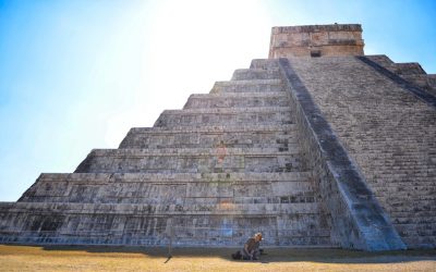
Cultural or Historical Sites of Belize: Important Cultural Landmarks or Historical Sites In Belize
Introduction Belize, a small country located on the eastern coast of Central America, is known for its rich history and cultural heritage. From ancient Maya ruins to colonial architecture, Belize offers a unique glimpse into the past. In addition to its historical sites, Belize is also home to natural wonders such as the Belize Barrier Reef and the Cockscomb Basin Wildlife Sanctuary. Exploring these ancient ruins, colonial architecture, and natural wonders is not only a way to appreciate Belize’s past, but also an opportunity to connect with its vibrant present. The Ancient Maya Ruins of Belize: A Window into Pre-Columbian Civilization The Maya civilization, one of the most advanced pre-Columbian civilizations in the Americas, flourished in what is now Belize from around 2000 BC to 1500 AD. The Maya left behind a rich legacy of art, architecture, and knowledge that can still be seen today in the ancient ruins scattered throughout Belize. These ruins offer a window into the lives and beliefs of the Maya people. One of the most popular Maya ruins in Belize is Xunantunich. Located near the border with Guatemala, Xunantunich was once a major ceremonial center and political hub. The site features impressive structures such as El Castillo, a towering pyramid that offers panoramic views of the surrounding jungle. Another notable Maya ruin in Belize is Tikal, located just across the border in Guatemala. Tikal was one of the largest and most powerful Maya cities, with towering temples and palaces that still awe visitors today. The Colonial Architecture of Belize City: A Legacy of British Influence Belize has a rich colonial history, having been under...

Exploring Belgium’s Population Density
Belgium, a small country located in Western Europe, is known for its high population density. With a land area of just over 30,000 square kilometers and a population of approximately 11.5 million people, Belgium has one of the highest population densities in Europe. This means that there are a large number of people living in a relatively small area, resulting in crowded cities and towns. Understanding population density is crucial for policymakers, planners, and citizens alike. It helps us to better understand the challenges and opportunities that come with high population density, and to develop strategies to create sustainable and livable communities. By examining the factors that contribute to population density in Belgium, we can gain insights into the social, economic, and political dynamics of the country. Summary Belgium has a high population density, with over 11 million people living in a relatively small area. The population is concentrated in urban areas, with Brussels being the most densely populated city in the country. Factors affecting population density in Belgium include historical and cultural factors, economic opportunities, and government policies. Urbanization has led to increased population density, but rural areas still play an important role in the country’s population distribution. Compared to other European countries, Belgium has a relatively high population density but also a high quality of life. Understanding the Population Distribution in Belgium The population distribution in Belgium is not evenly spread across the country. There are significant differences between the three main regions: Flanders, Wallonia, and Brussels. Flanders, located in the northern part of Belgium, has the highest population density, with major cities such as Antwerp and...

Exploring Belgium’s Climate Zones: Regional Weather Differences
Belgium, a small country located in Western Europe, is known for its diverse climate zones. Despite its relatively small size, Belgium experiences a range of weather patterns due to its geographical location and proximity to the North Sea. Understanding these climate zones is not only important for travellers planning their trips, but also for farmers and conservationists who rely on the weather patterns to make informed decisions. In this article, we will explore the different climate zones in Belgium, their characteristics, and the best times to visit each region. Summary Belgium has four main climate zones: maritime, continental, Ardennes, and coastal. The maritime climate zone is characterized by mild temperatures and high levels of precipitation. The continental climate zone experiences hot summers and cold winters with low precipitation. The Ardennes climate zone has cooler temperatures and higher levels of precipitation than the continental zone. The coastal climate zone has mild temperatures and moderate precipitation levels. Regional differences in temperature and precipitation can have a significant impact on agriculture and wildlife in Belgium. Climate change is affecting Belgium’s weather patterns, with increased temperatures and more extreme weather events. When packing for different climate zones in Belgium, it’s important to bring layers and waterproof clothing. The best times to visit each region depend on the climate zone, with summer being the most popular time for tourists. The Maritime Climate Zone The Maritime Climate Zone in Belgium is characterized by mild winters and cool summers. This climate zone is influenced by the North Sea, which moderates the temperatures and brings moisture to the region. The weather patterns in this zone are often...

Exploring Belgium’s Varied Terrain: Mountains, Valleys, and Plains
Belgium, a small country located in Western Europe, is known for its rich history, delicious cuisine, and stunning architecture. However, what many people may not realize is that Belgium also boasts a diverse and beautiful landscape. From the mountainous region of the Ardennes to the rolling hills of the Condroz, Belgium offers a wide range of natural beauty waiting to be explored. In this article, we will take a closer look at the different regions and landscapes that make up Belgium’s diverse terrain. Summary Belgium’s landscape is diverse and offers a range of unique regions to explore. The Ardennes is Belgium’s mountainous region and is perfect for outdoor activities. The Meuse and Sambre valleys offer stunning scenery and historic sites to visit. The Flemish Ardennes is a hilly landscape with picturesque villages and cycling routes. The coastal plains of Belgium offer a unique landscape with sandy beaches and dunes. The Ardennes: Belgium’s Mountainous Region Located in the southern part of Belgium, the Ardennes is a picturesque region known for its dense forests, rolling hills, and charming villages. This mountainous area covers about one-third of the country and is a popular destination for outdoor enthusiasts. Hiking is one of the most popular activities in the Ardennes, with numerous trails winding through the lush forests and offering breathtaking views of the surrounding landscape. In the winter months, skiing and snowboarding are also popular activities in the region. The Ardennes is home to several notable landmarks and attractions. One of the most famous is the town of Durbuy, often referred to as “the smallest city in the world.” With its medieval architecture...

Belgium’s Political Boundaries: Provinces, Districts or History?
Belgium is a country located in Western Europe and is known for its complex political system. It is a federal parliamentary democracy, which means that power is divided between the federal government and the regional governments. Understanding Belgium’s political boundaries is crucial for both Belgians and non-Belgians, as it helps to navigate the country’s governance structure and comprehend the diverse regional identities within the nation. Summary Belgium is divided into three regions: Flanders, Wallonia, and Brussels-Capital. Provinces in Belgium have limited powers and are mainly responsible for administrative tasks. Districts in Belgium are important for local governance and are responsible for services such as education and healthcare. Belgium’s political boundaries have evolved over time due to historical events and political negotiations. Regional identity in Belgium is strongly tied to language and cultural differences. The Role of Provinces in Belgium’s Political System Provinces in Belgium are administrative divisions that play a significant role in the country’s political system. There are ten provinces in Belgium, each with its own governor and provincial council. The provinces have various responsibilities, including managing local infrastructure, education, culture, and public safety. They also act as intermediaries between the federal government and the municipalities within their jurisdiction. Provinces are an essential part of Belgium’s federal system, as they help to decentralize power and ensure that regional interests are represented. They provide a level of governance that is closer to the people, allowing for more localized decision-making. Provinces also serve as a link between the federal government and the municipalities, helping to coordinate policies and initiatives at different levels of government. Understanding Belgium’s Districts and their Importance...

Belgium’s Cultural and Historical Gems: Must-Visit Sites
Belgium, a small country located in Western Europe, is often overlooked by travelers in favor of its more famous neighbors such as France and Germany. However, this charming country has a rich history and culture that is worth exploring. From its medieval towns and Gothic cathedrals to its vibrant art scene and delicious cuisine, Belgium offers a diverse range of attractions that will captivate any visitor. In this article, we will take a journey through time and explore Belgium’s fascinating history, discover the iconic landmarks of its capital city Brussels, visit its magnificent cathedrals, uncover its artistic contributions, explore its charming towns and villages, commemorate its role in World War I, indulge in its culinary delights, delve into its contribution to the art world, soak up the sun and sea on its coast, and unearth its hidden treasures. Summary Belgium has a rich history that can be explored through its many landmarks and attractions. Brussels is home to iconic landmarks such as the Atomium and the Grand Place, which are must-see destinations. Belgium’s cathedrals, such as the Cathedral of St. Michael and St. Gudula, are magnificent examples of Gothic architecture. Belgium’s art and architecture scene is vibrant and diverse, with notable contributions to the Surrealist movement. Belgium’s countryside is dotted with charming towns and villages, offering a glimpse into traditional Belgian life. A Journey Through Time: Exploring Belgium’s Rich History Belgium’s history dates back to Roman times when it was part of the Roman province of Gallia Belgica. Over the centuries, it has been influenced by various European powers including the Spanish, French, and Dutch. One of the most...

Discover Belgium Natural Resources: Economy of Belgium
Discover Belgium Natural Resources: Economy of Belgium Belgium may be small in size, but it plays a significant role in the European and global economy. This article explores the natural resources of Belgium and how they influence the economy of Belgium, including its coal, natural gas, and water resources, among others. Whether you’re a student, researcher, or just curious about how Belgium’s natural resource base supports its industries, energy mix, and GDP, this is a must-read! Despite its relatively limited mineral wealth compared to some larger European countries, Belgium’s economy thrives on the smart utilisation of available resources, a highly developed transport and service sector, and a strategic position in Western Europe. Read on to understand the nuances of Belgium’s natural resources, its historical role, and future sustainability challenges. Article Outline What Are the Major Natural Resources in Belgium? How Have Belgium’s Coal Reserves Shaped Its Industrial Past? What Role Does Natural Gas Play in Belgium’s Energy Mix? Are Water Resources in Belgium Sufficient and Sustainable? How Important Are Zinc and Lead Deposits to Belgium? What Is the Status of Silica and Limestone Resources in Belgium? What Contribution Do Belgium’s Forests and Timber Make to the Economy? How Is Renewable Energy Evolving in Belgium? How Do Natural Resources Affect the GDP and Major Industries in Belgium? What Are the Environmental Concerns Related to Belgium’s Resource Use? 1. What Are the Major Natural Resources in Belgium? Though Belgium is located in Western Europe with a modest land area, it possesses a variety of natural resources that have historically supported its industrial and economic development. Key natural resources include coal,...

Population Density of Belarus
Population density refers to the number of people living in a specific area, usually measured as the number of individuals per square kilometer. It is an important indicator of the distribution of population within a country and provides insights into the social, economic, and environmental aspects of a region. Studying population density in Belarus is crucial for understanding the country’s demographic patterns, urbanization trends, and their impact on economic development and environmental sustainability. Belarus, officially known as the Republic of Belarus, is a landlocked country located in Eastern Europe. It shares borders with Russia to the east, Ukraine to the south, Poland to the west, and Lithuania and Latvia to the northwest. With a total land area of approximately 207,600 square kilometers, Belarus is home to a diverse population that has experienced significant changes in population density over the years. Summary Belarus has a population density of 46 people per square kilometre. Population density in Belarus has fluctuated throughout history due to factors such as war and migration. The highest population densities in Belarus are found in the central and eastern regions. Factors influencing population density in Belarus include economic opportunities and access to resources. Urbanization has led to increased population density in Belarus, while rural-urban migration has had a mixed impact. Historical Trends in Belarusian Population Density In the early 20th century, Belarus had a relatively low population density compared to other European countries. This was primarily due to its rural nature and agricultural economy. The population density increased during Soviet rule as industrialization efforts led to urbanization and migration from rural areas to cities. The population density...
Terrain and Topography of Belarus: mountains, valleys, and plains.
Belarus, located in Eastern Europe, is a landlocked country known for its rich history, vibrant culture, and diverse natural landscapes. Understanding the terrain and topography of Belarus is crucial in comprehending the country’s unique characteristics and its impact on various aspects of life, including climate, agriculture, and development. From the flatlands of the Great European Plain to the hilly regions of the Grodno Upland and the marshy Polesian Lowland, Belarus offers a wide range of landscapes that contribute to its beauty and diversity. Summary Belarus is a country with diverse terrain and topography. The Great European Plain dominates the landscape of Belarus. The Belarusian Ridge is the highest point in the country. The Polesian Lowland is a marshy region in southern Belarus. The Belarusian Lake District is a region of glacial lakes in the north. The Flatlands of Belarus: The Great European Plain The Great European Plain is a vast lowland that stretches across several countries in Eastern Europe, including Belarus. This flatland covers a significant portion of Belarus’ territory and has a profound influence on the country’s climate and agriculture. The plain is characterized by fertile soil, making it ideal for agricultural activities such as farming and livestock rearing. The flatlands are home to several cities and landmarks that showcase Belarus’ rich history and culture. Minsk, the capital city, is situated in the central part of the country and serves as a hub for economic, political, and cultural activities. Other notable cities in the flatlands include Brest, Gomel, and Mogilev. These cities are known for their architectural beauty, historical sites, and vibrant cultural scenes. The Belarusian Ridge: The...
Political Boundaries of Belarus: Provinces, Districts, or Historical Boundaries.
Belarus, officially known as the Republic of Belarus, is a landlocked country located in Eastern Europe. It shares its borders with five countries: Russia to the east and northeast, Ukraine to the south, Poland to the west, Lithuania to the northwest, and Latvia to the north. Understanding the political boundaries of Belarus is crucial for effective governance and administration of the country. Political boundaries define the territorial limits of a country and play a significant role in determining its governance structure. They establish the jurisdiction of different levels of government and help in the allocation of resources and provision of services. By understanding the political boundaries of Belarus, policymakers can make informed decisions about resource allocation, infrastructure development, and service delivery. Summary Belarus is a landlocked country in Eastern Europe with political boundaries that have evolved over time. The country is divided into six administrative regions called provinces, each with its own capital city. Belarus has 118 districts, which are important for local governance and economic development. The historical boundaries of Belarus have been shaped by wars, treaties, and political agreements. The future of Belarus political boundaries is uncertain, with challenges related to economic development, ethnic diversity, and international relations. Administrative Divisions of Belarus Belarus is divided into six administrative divisions: provinces, districts, cities with special status, urban districts, townships, and rural councils. The administrative divisions are hierarchical in nature, with each level having its own set of responsibilities and powers. The provinces, also known as oblasts, are the highest level of administrative division in Belarus. There are six provinces in total: Brest, Gomel, Grodno, Minsk, Mogilev, and Vitebsk....

Climate Zones of Belarus: Different climate regions Of Belarus
Belarus, located in Eastern Europe, is a landlocked country with a diverse geography and climate. It is bordered by Russia to the east, Ukraine to the south, Poland to the west, and Lithuania and Latvia to the northwest. The country’s climate is influenced by its continental location and proximity to the Baltic Sea. Understanding Belarus’ climate zones is important for various reasons, including agriculture, tourism, and infrastructure planning. Summary Belarus has a diverse range of climate zones, including continental, oceanic, transitional, mountainous, boreal forest, steppe, and arid regions. The continental climate region is characterized by cold winters and warm summers, with significant temperature fluctuations throughout the year. The oceanic climate region experiences mild temperatures and high levels of precipitation throughout the year. The transitional climate region has a mix of continental and oceanic influences, resulting in moderate temperatures and moderate precipitation levels. Climate change is having a significant impact on Belarus’ climate zones, including changes in temperature, precipitation patterns, and extreme weather events. The continental climate region of Belarus The continental climate region covers a large part of Belarus and is characterized by cold winters and warm summers. The temperature range in this zone can be quite extreme, with temperatures dropping below freezing in winter and reaching highs of 30°C (86°F) or more in summer. Precipitation in this zone is relatively evenly distributed throughout the year, with slightly higher rainfall in summer. Cities or regions in this climate zone include Minsk, the capital city of Belarus, as well as Brest, Gomel, and Mogilev. These cities experience cold winters with average temperatures ranging from -4°C (24°F) to -8°C (18°F) and...
Cultural or Historical Sites of Belarus: Important Cultural Landmarks or Historical Sites In Belarus
Belarus, located in Eastern Europe, is a country rich in culture and history. Over the centuries, it has been influenced by various civilizations and empires, resulting in a unique blend of traditions and customs. From its medieval castles to its vibrant art scene, Belarusian culture is a testament to the resilience and creativity of its people. Preserving this cultural heritage is of utmost importance, as it allows future generations to connect with their roots and understand the country’s rich history. Summary Belarusian National Arts Museum showcases the country’s rich artistic heritage. Brest Fortress stands as a symbol of Belarusian resistance against Nazi invasion. Mir Castle Complex is a UNESCO World Heritage Site and a stunning example of medieval architecture. Nesvizh Castle was once the residence of the powerful Radziwill family and is now a popular tourist attraction. The Great Synagogue of Slonim is a testament to Belarusian Jewish heritage and a reminder of the country’s diverse cultural history. Belarusian National Arts Museum: A Hub of Art and Culture The Belarusian National Arts Museum, located in Minsk, is a hub of art and culture in the country. Established in 1939, the museum houses an extensive collection of Belarusian and international art, spanning from the 12th century to the present day. Its collections include paintings, sculptures, graphic art, decorative art, and folk art. One of the highlights of the museum is its collection of Belarusian icons, which provides a glimpse into the country’s religious and artistic traditions. These icons are not only beautiful works of art but also important religious artifacts that have played a significant role in Belarusian culture. Another...