World Geography
Geography is the study of the Earth’s landscapes, environments, and the relationships between people and their surroundings. It encompasses both the physical aspects of the Earth, such as its landforms, bodies of water, and climate, as well as the human aspects, including population distribution, cultures, and economies. World geography is a broad field that seeks to understand the complexities of our planet and how humans interact with it. By studying world geography, we can gain a deeper appreciation for the diversity of our planet and the interconnectedness of its various regions.
Geography is a multidisciplinary field that draws on elements of physical science, social science, and humanities. It involves the use of maps, spatial analysis, and geographic information systems (GIS) to understand the Earth’s surface and the processes that shape it. World geography also encompasses the study of human geography, which examines the ways in which people and their activities are distributed across the Earth. By understanding world geography, we can better appreciate the environmental, cultural, and economic challenges facing different regions of the world. This knowledge is crucial for addressing global issues such as climate change, resource management, and international development.
The Five Oceans and Seven Continents
The Earth’s surface is divided into five major oceans: the Pacific, Atlantic, Indian, Southern (or Antarctic), and Arctic Oceans. These vast bodies of water play a crucial role in regulating the Earth’s climate and supporting diverse marine ecosystems. The oceans also serve as important transportation routes and a source of food and other natural resources for human societies around the world.
In addition to the oceans, the Earth’s landmasses are divided into seven continents: Africa, Antarctica, Asia, Europe, North America, Australia (or Oceania), and South America. Each continent has its own unique physical and cultural characteristics, shaped by millions of years of geological processes and human history. From the deserts of Africa to the rainforests of South America, the continents offer a rich tapestry of landscapes and environments for exploration and study.
Major Mountain Ranges and Deserts
The Earth’s surface is also marked by major mountain ranges and deserts that have shaped the planet’s physical and cultural landscapes. The Himalayas, for example, are the highest mountain range in the world and are home to diverse ecosystems and cultures in countries such as India, Nepal, and Bhutan. The Andes in South America, the Rockies in North America, and the Alps in Europe are other prominent mountain ranges that have influenced human settlement patterns and economic activities.
Deserts cover about one-third of the Earth’s land surface and are characterized by low precipitation and extreme temperatures. The Sahara Desert in Africa is the largest hot desert in the world, while the Gobi Desert in Asia is one of the largest cold deserts. Deserts are not only home to unique flora and fauna but have also been important trade routes and cultural crossroads throughout history.
Climate Zones and Biomes
The Earth’s climate is influenced by a variety of factors, including latitude, altitude, ocean currents, and prevailing winds. As a result, the planet is divided into different climate zones, each with its own characteristic weather patterns and ecosystems. The equator, for example, experiences a tropical climate with high temperatures and heavy rainfall, while the polar regions have a cold and dry climate.
These climate zones give rise to different biomes, or large ecological areas characterized by distinct plant and animal communities. The tropical rainforest biome, found near the equator, is home to a diverse array of species and is vital for regulating the Earth’s climate. The grasslands biome, found in regions such as the African savannah and North American prairies, supports grazing animals and has been important for human agriculture throughout history.
Human Geography and Population Distribution
Human geography examines the ways in which people and their activities are distributed across the Earth’s surface. It encompasses topics such as population growth, migration patterns, urbanization, and cultural diversity. Understanding human geography is crucial for addressing global challenges such as poverty, inequality, and environmental degradation.
Population distribution is uneven across the world, with some regions experiencing rapid population growth while others are declining. The majority of the world’s population lives in Asia, particularly in countries such as China and India. Urban areas are also growing rapidly, with more than half of the world’s population now living in cities. This trend has significant implications for infrastructure development, resource management, and social inequality.
Historical and Cultural Geography
Historical geography examines how human activities have shaped the Earth’s landscapes over time. It explores topics such as colonialism, trade routes, and the rise and fall of empires. Cultural geography focuses on how human cultures have developed in different regions of the world and how they interact with their environments.
The Silk Road, for example, was an ancient trade route that connected China with Europe and facilitated the exchange of goods, ideas, and technologies across Eurasia. This historical trade route had a profound impact on the development of cultures and economies along its path. Similarly, cultural geographers study how different societies have adapted to their environments through practices such as agriculture, architecture, and religious beliefs.
The Importance of Geographic Knowledge
Geographic knowledge is crucial for addressing global challenges such as climate change, resource management, and international development. By understanding world geography, we can better appreciate the environmental, cultural, and economic challenges facing different regions of the world. This knowledge is crucial for addressing global issues such as climate change, resource management, and international development.
Geographic knowledge also helps us to understand our interconnectedness with other regions of the world. By studying world geography, we can gain a deeper appreciation for the diversity of our planet and the interconnectedness of its various regions. This understanding can foster a sense of global citizenship and empathy for people from different cultures and backgrounds.
In conclusion, world geography is a complex and multifaceted field that encompasses both physical and human aspects of the Earth’s landscapes. By studying world geography, we can gain a deeper appreciation for the diversity of our planet and the interconnectedness of its various regions. This knowledge is crucial for addressing global challenges such as climate change, resource management, and international development. It also helps us to understand our interconnectedness with other regions of the world and fosters a sense of global citizenship.
FAQs
What is world geography?
World geography is the study of the Earth’s landscapes, environments, and the relationships between people and their environments. It encompasses the physical features of the Earth, as well as the human activity that takes place on it.
Why is world geography important?
World geography is important because it helps us understand the world around us. It provides insights into the physical and human processes that shape our planet, and helps us make informed decisions about how to interact with our environment.
What are the main branches of world geography?
The main branches of world geography include physical geography, which focuses on the Earth’s natural features and processes, and human geography, which examines the relationships between people and their environments.
How does world geography impact our daily lives?
World geography impacts our daily lives in numerous ways, from influencing the weather and climate we experience, to shaping the availability of natural resources and influencing the distribution of populations and cultures around the world.
What are some key concepts in world geography?
Key concepts in world geography include location, place, human-environment interaction, movement, and region. These concepts help geographers understand and interpret the world around them.

Exploring the Rich Flora and Fauna of Wallis and Futuna
Wallis and Futuna, a small French overseas collectivity located in the South Pacific, is often overshadowed by its more famous neighbours such as Fiji and Samoa. Comprising three main islands—Wallis, Futuna, and the smaller island of Alofi—this remote archipelago is situated approximately halfway between Tonga and Samoa. The islands are known for their rich cultural heritage, which is a blend of Polynesian traditions and French influences. The population, numbering around 12,000, primarily consists of Polynesian people who maintain a strong connection to their ancestral customs, language, and communal lifestyle. The geographical features of Wallis and Futuna are strikingly diverse. Wallis Island is volcanic in origin, characterised by its rugged terrain, lush vegetation, and a central mountain range that rises dramatically from the surrounding lagoon. In contrast, Futuna is predominantly limestone, with its landscape shaped by coral reefs and steep cliffs. The islands are encircled by vibrant coral reefs that teem with marine life, making them a hidden gem for those interested in biodiversity. The isolation of Wallis and Futuna has allowed for the development of unique ecosystems that are home to a variety of endemic species, both flora and fauna, which are crucial to the ecological balance of the region. Summary Wallis and Futuna is a French overseas collectivity located in the South Pacific, known for its stunning natural beauty and rich biodiversity. The unique flora of Wallis and Futuna includes a variety of endemic plant species, such as the native pandanus and coconut palms, as well as a diverse range of tropical flowers and fruits. The diverse fauna of Wallis and Futuna is home to a wide array...

Exploring the Biodiversity of Vanuatu’s Flora and Fauna
Vanuatu, an archipelago located in the South Pacific Ocean, is renowned for its stunning landscapes and rich cultural heritage. However, it is perhaps less well-known for its remarkable biodiversity, which encompasses a wide array of unique flora and fauna. Comprising approximately 83 islands, Vanuatu boasts a variety of ecosystems, ranging from lush rainforests and mangroves to coral reefs and volcanic landscapes. This diversity of habitats supports an impressive range of species, many of which are endemic to the islands. The intricate web of life found in Vanuatu is not only vital for the ecological balance of the region but also plays a significant role in the cultural identity and livelihoods of the local communities. The biodiversity of Vanuatu is a product of its geological history and climatic conditions. The islands have been shaped by volcanic activity, resulting in a complex topography that creates microclimates conducive to various forms of life. The tropical climate, characterised by warm temperatures and seasonal rainfall, further enhances the growth of diverse plant and animal species. As a result, Vanuatu is home to numerous endemic species that cannot be found anywhere else on Earth. This unique biodiversity is not merely a natural treasure; it also holds immense potential for scientific research, sustainable development, and ecotourism, making it imperative to understand and protect these natural resources. Summary Vanuatu is home to a rich and diverse range of flora and fauna, making it a hotspot for biodiversity. The unique flora of Vanuatu includes a variety of endemic plant species, such as the Vanuatu fan palm and the Vanuatu pitcher plant. The diverse fauna of Vanuatu includes a...

Exploring the Rich Flora and Fauna of Vietnam
Vietnam is a country renowned for its remarkable biodiversity, which is largely attributed to its varied topography and climate. Stretching from the northern mountainous regions to the southern Mekong Delta, Vietnam’s ecosystems encompass a wide range of habitats, including tropical rainforests, mangroves, coral reefs, and limestone karsts. The northern highlands are characterised by rugged mountains and deep valleys, where temperate forests thrive, providing a habitat for numerous endemic species. In contrast, the coastal areas are home to rich marine ecosystems that support a plethora of marine life, including vibrant coral reefs and diverse fish populations. The central region of Vietnam features unique ecosystems such as the Annamite Range, which is a biodiversity hotspot. This area is home to many species that are not found anywhere else in the world, including the critically endangered saola (Pseudoryx nghetinhensis), often referred to as the “Asian unicorn.” The southern part of the country, particularly the Mekong Delta, showcases a different ecological landscape with its intricate network of rivers and swamps. This region is vital for both local wildlife and human communities, as it supports agriculture and fishing while also serving as a crucial habitat for various bird species and aquatic life. Summary Vietnam is home to diverse ecosystems including tropical rainforests, mangroves, coral reefs, and highland forests. Endangered species in Vietnam include the Javan rhinoceros, Indochinese tiger, and Tonkin snub-nosed monkey, with conservation efforts focused on protecting their habitats and combating poaching. Unique plants and flowers in Vietnam include the lotus, apricot blossom, and orchids, which are celebrated in traditional festivals and cultural events. Birdwatching and wildlife spotting are popular activities in Vietnam,...

Exploring the Flora and Fauna of US Virgin Islands
The United States Virgin Islands (USVI) is a captivating Caribbean territory that comprises the main islands of Saint Thomas, Saint John, and Saint Croix, along with numerous smaller islets. Renowned for their stunning beaches, crystal-clear waters, and vibrant culture, these islands are a popular destination for tourists seeking both relaxation and adventure. The US Virgin Islands boast a rich history influenced by various colonial powers, including the Danish, who ruled the islands for over 250 years before selling them to the United States in 1917. This historical tapestry is woven into the very fabric of the islands, evident in their architecture, cuisine, and local traditions. The geographical diversity of the US Virgin Islands contributes significantly to their allure. Each island possesses its unique character; Saint Thomas is known for its bustling port and vibrant nightlife, while Saint John is celebrated for its pristine national park and unspoiled natural beauty. Saint Croix, the largest of the three, offers a blend of cultural experiences and historical sites, making it a microcosm of the Caribbean experience. The islands’ tropical climate, characterised by warm temperatures and seasonal rainfall, supports a rich array of ecosystems that are home to an impressive variety of flora and fauna. This natural wealth not only enhances the islands’ aesthetic appeal but also plays a crucial role in their ecological balance. Summary The US Virgin Islands are a group of Caribbean islands known for their stunning natural beauty and rich biodiversity. The diverse flora of the US Virgin Islands includes a wide variety of plant species, from lush tropical rainforests to arid coastal areas. The fascinating fauna of the...

Tropical Zones – Tropical Climate and Tropical Weather in Tropical Countries
Tropical Areas – Tropical Climate and Tropical Weather in Tropical Countries The tropical areas are home to Earth’s most vibrant ecosystems, unique weather patterns, and iconic destinations. This article dives into the science behind tropical climates, their impact on global weather systems, and why regions within the tropics—from lush rainforests to sun-soaked islands—captivate travellers and scientists alike. Whether you’re planning a trip to a tropical paradise or curious about how these regions shape our planet, this guide offers actionable insights and fascinating details you won’t want to miss. Article Outline What Defines a Tropical Climate? How Does the Köppen Climate Classification Categorise Tropical Zones? Tropical Rainforests vs. Tropical Monsoon Climates: What’s the Difference? Why Do Tropical Regions Have Wet and Dry Seasons? How Does Latitude Influence Tropical Weather Systems? What Role Do the Tropics Play in Global Meteorology? Which Countries Offer the Best Tropical Experiences? How Do El Niño and La Niña Affect Tropical Climates? What Unique Plants and Animals Thrive in Tropical Biomes? Are Tropical Regions at Risk Due to Climate Change? 1. What Defines a Tropical Climate? A tropical climate is characterised by high temperatures (averaging 18°C or higher year-round) and significant precipitation, with minimal seasonal temperature variations. These regions lie within the tropics, between 23.5°N (Tropic of Cancer) and 23.5°S (Tropic of Capricorn) latitude. The equator divides this zone, where solar radiation is most intense, fueling consistent warmth and humidity. Key features include wet and dry seasons, dense vegetation like rainforests, and weather phenomena such as monsoons. Unlike temperate regions, tropical areas experience little variation in daylight hours, contributing to stable temperature and humidity levels. Countries like Brazil and Indonesia epitomize...
Exploring the Flora and Fauna of British Virgin Islands
The British Virgin Islands (BVI), an enchanting archipelago located in the Caribbean, is renowned for its stunning natural beauty, crystal-clear waters, and vibrant culture. Comprising around 60 islands and cays, the BVI is a British Overseas Territory that boasts a rich history influenced by indigenous peoples, European colonisation, and a thriving maritime economy. The largest island, Tortola, serves as the administrative and economic hub, while other notable islands include Virgin Gorda, Anegada, and Jost Van Dyke. Each island possesses its unique charm, offering visitors a diverse range of experiences from tranquil beaches to lush mountainous landscapes. The BVI is not only a paradise for beach lovers and sailors but also a haven for nature enthusiasts. The islands are characterised by their tropical climate, which supports a rich tapestry of flora and fauna. The unique geographical features of the BVI, including its volcanic origins and coral reefs, create an environment that is both ecologically significant and visually stunning. This article delves into the diverse plant and animal life found in the British Virgin Islands, the ongoing conservation efforts to protect these natural resources, and the best locations for exploring this Caribbean gem. Summary The British Virgin Islands are a group of 60 islands known for their stunning natural beauty and rich biodiversity. The flora of the British Virgin Islands includes a variety of tropical plants such as orchids, hibiscus, and frangipani. The fauna of the British Virgin Islands is diverse, with species such as iguanas, flamingos, and sea turtles inhabiting the islands. Conservation efforts in the British Virgin Islands focus on protecting the delicate marine and terrestrial ecosystems, including the...

Sea of Galilee
The Sea of Galilee, known in Hebrew as Lake Kinneret, is a freshwater lake located in northern Israel. It is the largest freshwater lake in the country and holds a prominent place in both the geographical and cultural landscape of the region. Nestled between the Golan Heights to the east and the Galilee mountains to the west, the lake spans approximately 21 kilometres in length and 13 kilometres in width, with a maximum depth of around 43 metres. Its significance extends beyond mere geography; it is a site steeped in history, spirituality, and natural beauty. The Sea of Galilee has been a focal point for various civilisations throughout history, serving as a vital resource for agriculture, trade, and transportation. Its waters are fed by the Jordan River, which flows from the north and exits to the south, creating a dynamic ecosystem that supports diverse flora and fauna. The lake’s serene beauty and historical richness attract visitors from around the globe, making it a key destination for both pilgrims and tourists alike. As we delve deeper into its geography, history, and cultural significance, we uncover layers of meaning that contribute to the Sea of Galilee’s enduring legacy. Summary The Sea of Galilee, also known as Lake Tiberias, is a freshwater lake in Israel and the lowest freshwater lake on Earth. The Sea of Galilee is surrounded by hills and mountains, with the Jordan River flowing through it and the Golan Heights to the east. The Sea of Galilee has been a site of historical significance, with many ancient cities and archaeological sites surrounding its shores. The Sea of Galilee holds...
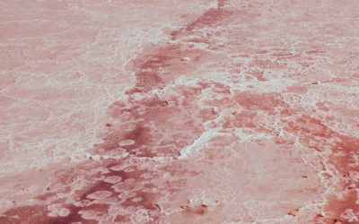
Dead Sea
The Dead Sea, a remarkable body of water situated at the lowest point on Earth, has captivated the attention of scholars, tourists, and health enthusiasts alike for centuries. Nestled between Jordan to the east and Israel and Palestine to the west, this saline lake is renowned not only for its extreme salinity but also for its historical and cultural significance. The Dead Sea is a unique ecosystem that has been shaped by geological processes over millennia, resulting in a landscape that is both stark and beautiful. Its waters, rich in minerals, have been sought after for their therapeutic properties, making the Dead Sea a focal point for wellness tourism. The name “Dead Sea” is derived from the fact that its high salinity prevents most aquatic life from thriving within its waters. This characteristic has led to a perception of desolation; however, the surrounding region is teeming with life and history. The Dead Sea has been a source of fascination since ancient times, mentioned in biblical texts and revered by various cultures for its healing properties. Today, it continues to draw visitors from around the globe, eager to experience its unique environment and rich heritage. Summary The Dead Sea is a saltwater lake bordered by Jordan to the east and Israel and Palestine to the west. It is the lowest point on Earth and is known for its high salt and mineral content, making it impossible for most forms of life to exist in its waters. The unique properties of the Dead Sea, including its high salt and mineral content, have made it a popular destination for health and wellness...
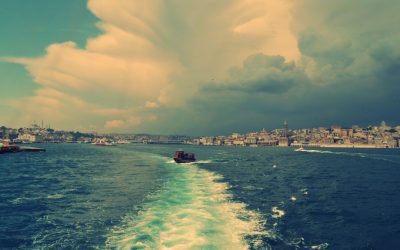
Marmara Sea
The Marmara Sea, a unique body of water that connects the Aegean Sea to the Black Sea, serves as a vital geographical and ecological link between Europe and Asia. This relatively small sea, measuring approximately 11,350 square kilometres, is not only significant for its strategic location but also for its rich biodiversity and historical importance. The Marmara Sea is often overshadowed by its larger counterparts, yet it plays a crucial role in the maritime activities of Turkey and the surrounding regions. Its waters are a blend of saltwater from the Aegean and freshwater from the Black Sea, creating a unique marine environment that supports a variety of life forms. The sea is bordered by several major cities, including Istanbul, which straddles both continents and serves as a cultural and economic hub. The Marmara Sea is also home to numerous islands, such as the Princes’ Islands, which are popular destinations for both locals and tourists. The interplay of natural beauty and human activity makes the Marmara Sea a fascinating subject of study, revealing insights into the ecological balance and the impact of human intervention on marine environments. Summary The Marmara Sea is a small inland sea located in northwestern Turkey, connecting the Black Sea to the Aegean Sea. The Marmara Sea is surrounded by the densely populated and industrialized Marmara region, making it a hub for economic activities and trade. The sea is home to a diverse range of marine life, including dolphins, sea turtles, and various species of fish and crustaceans. Human activities such as shipping, fishing, and tourism have had a significant impact on the Marmara Sea, leading...
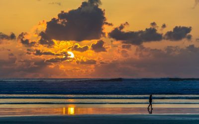
Ligurian Sea
The Ligurian Sea, a picturesque body of water nestled between the Italian Riviera and the French coastline, is a significant part of the Mediterranean Sea. It is bordered by the regions of Liguria in Italy and Provence-Alpes-Côte d’Azur in France, making it a vital maritime corridor that has shaped the cultural and economic landscapes of the surrounding areas. The sea is not only known for its stunning vistas and charming coastal towns but also for its rich biodiversity and historical importance. As a crucial link in maritime trade routes, the Ligurian Sea has been a witness to centuries of human activity, from ancient seafaring to modern tourism. The Ligurian Sea is often celebrated for its dramatic cliffs, azure waters, and vibrant marine ecosystems. It serves as a habitat for numerous species of fish and marine mammals, while also being a popular destination for recreational activities such as sailing, diving, and swimming. The sea’s unique geographical features, including its deep basins and narrow straits, contribute to its ecological richness and make it an area of interest for scientists and environmentalists alike. As we delve deeper into the various aspects of the Ligurian Sea, we will uncover its geographical features, marine life, environmental challenges, cultural significance, economic activities, recreational opportunities, and future prospects. Summary The Ligurian Sea is located in the northwestern part of the Mediterranean Sea, bordered by Italy, France, and Monaco. It is characterized by its deep blue waters, rugged coastline, and picturesque coastal towns, making it a popular tourist destination. The Ligurian Sea is home to a diverse range of marine life, including dolphins, whales, and various species...
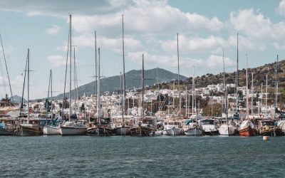
Tyrrhenian Sea
The Tyrrhenian Sea, a prominent body of water in the central Mediterranean, is bordered by the western coast of Italy, the islands of Sardinia and Corsica, and the eastern shores of the Italian peninsula. This sea is not only a geographical landmark but also a cultural and historical nexus that has shaped the lives of countless communities over millennia. Its name is derived from the ancient Etruscans, known as the Tyrrhenians, who inhabited parts of Italy before the rise of the Roman Empire. The Tyrrhenian Sea serves as a vital maritime route, connecting various regions and facilitating trade, travel, and cultural exchange. The sea’s significance extends beyond its strategic location; it is a rich tapestry of biodiversity and natural beauty. The interplay of land and sea creates a unique environment that supports a wide array of marine life and ecosystems. The Tyrrhenian Sea is also a focal point for various human activities, from fishing to tourism, which have both positive and negative impacts on its health and sustainability. Understanding the complexities of this sea is essential for appreciating its role in the Mediterranean region and the broader ecological landscape. Summary The Tyrrhenian Sea is located in the Mediterranean and is bordered by the Italian peninsula, the island of Sardinia, and the island of Corsica. The Tyrrhenian Sea is known for its deep trenches, volcanic activity, and rich biodiversity, making it a popular destination for divers and marine enthusiasts. The Tyrrhenian Sea is home to a variety of marine life, including dolphins, whales, sea turtles, and a wide range of fish species. Human activities in the Tyrrhenian Sea include fishing,...

Ionian Sea
The Ionian Sea, a significant body of water in the Mediterranean, is renowned for its stunning landscapes, rich history, and vibrant marine ecosystems. Nestled between the western coast of Greece and the eastern shores of Italy, this sea has been a crucial maritime route since ancient times, facilitating trade, cultural exchange, and exploration. The Ionian Sea is not merely a geographical feature; it embodies a tapestry of human experience, from the ancient Greeks who revered its waters to modern-day tourists seeking its beauty and tranquillity. The sea is often celebrated for its crystal-clear waters, picturesque islands, and charming coastal towns. It has inspired countless artists, poets, and writers throughout history, serving as a backdrop for both mythological tales and real-life adventures. The Ionian Sea is also a vital ecological zone, home to diverse marine life and unique habitats that contribute to the overall health of the Mediterranean ecosystem. As we delve deeper into the various aspects of the Ionian Sea, we will uncover its geographical significance, climatic conditions, rich biodiversity, historical context, and the pressing environmental challenges it faces today. Summary The Ionian Sea is located in the Mediterranean and is bordered by several countries including Italy, Albania, and Greece. The climate in the Ionian Sea is typically mild with hot, dry summers and mild, wet winters, making it an ideal destination for tourists. The marine life in the Ionian Sea is diverse, with a variety of fish, dolphins, and sea turtles inhabiting its waters. The Ionian Sea has a rich history and culture, with influences from ancient Greek, Roman, and Byzantine civilizations. Tourism in the Ionian Sea is...