World Geography
Geography is the study of the Earth’s landscapes, environments, and the relationships between people and their surroundings. It encompasses both the physical aspects of the Earth, such as its landforms, bodies of water, and climate, as well as the human aspects, including population distribution, cultures, and economies. World geography is a broad field that seeks to understand the complexities of our planet and how humans interact with it. By studying world geography, we can gain a deeper appreciation for the diversity of our planet and the interconnectedness of its various regions.
Geography is a multidisciplinary field that draws on elements of physical science, social science, and humanities. It involves the use of maps, spatial analysis, and geographic information systems (GIS) to understand the Earth’s surface and the processes that shape it. World geography also encompasses the study of human geography, which examines the ways in which people and their activities are distributed across the Earth. By understanding world geography, we can better appreciate the environmental, cultural, and economic challenges facing different regions of the world. This knowledge is crucial for addressing global issues such as climate change, resource management, and international development.
The Five Oceans and Seven Continents
The Earth’s surface is divided into five major oceans: the Pacific, Atlantic, Indian, Southern (or Antarctic), and Arctic Oceans. These vast bodies of water play a crucial role in regulating the Earth’s climate and supporting diverse marine ecosystems. The oceans also serve as important transportation routes and a source of food and other natural resources for human societies around the world.
In addition to the oceans, the Earth’s landmasses are divided into seven continents: Africa, Antarctica, Asia, Europe, North America, Australia (or Oceania), and South America. Each continent has its own unique physical and cultural characteristics, shaped by millions of years of geological processes and human history. From the deserts of Africa to the rainforests of South America, the continents offer a rich tapestry of landscapes and environments for exploration and study.
Major Mountain Ranges and Deserts
The Earth’s surface is also marked by major mountain ranges and deserts that have shaped the planet’s physical and cultural landscapes. The Himalayas, for example, are the highest mountain range in the world and are home to diverse ecosystems and cultures in countries such as India, Nepal, and Bhutan. The Andes in South America, the Rockies in North America, and the Alps in Europe are other prominent mountain ranges that have influenced human settlement patterns and economic activities.
Deserts cover about one-third of the Earth’s land surface and are characterized by low precipitation and extreme temperatures. The Sahara Desert in Africa is the largest hot desert in the world, while the Gobi Desert in Asia is one of the largest cold deserts. Deserts are not only home to unique flora and fauna but have also been important trade routes and cultural crossroads throughout history.
Climate Zones and Biomes
The Earth’s climate is influenced by a variety of factors, including latitude, altitude, ocean currents, and prevailing winds. As a result, the planet is divided into different climate zones, each with its own characteristic weather patterns and ecosystems. The equator, for example, experiences a tropical climate with high temperatures and heavy rainfall, while the polar regions have a cold and dry climate.
These climate zones give rise to different biomes, or large ecological areas characterized by distinct plant and animal communities. The tropical rainforest biome, found near the equator, is home to a diverse array of species and is vital for regulating the Earth’s climate. The grasslands biome, found in regions such as the African savannah and North American prairies, supports grazing animals and has been important for human agriculture throughout history.
Human Geography and Population Distribution
Human geography examines the ways in which people and their activities are distributed across the Earth’s surface. It encompasses topics such as population growth, migration patterns, urbanization, and cultural diversity. Understanding human geography is crucial for addressing global challenges such as poverty, inequality, and environmental degradation.
Population distribution is uneven across the world, with some regions experiencing rapid population growth while others are declining. The majority of the world’s population lives in Asia, particularly in countries such as China and India. Urban areas are also growing rapidly, with more than half of the world’s population now living in cities. This trend has significant implications for infrastructure development, resource management, and social inequality.
Historical and Cultural Geography
Historical geography examines how human activities have shaped the Earth’s landscapes over time. It explores topics such as colonialism, trade routes, and the rise and fall of empires. Cultural geography focuses on how human cultures have developed in different regions of the world and how they interact with their environments.
The Silk Road, for example, was an ancient trade route that connected China with Europe and facilitated the exchange of goods, ideas, and technologies across Eurasia. This historical trade route had a profound impact on the development of cultures and economies along its path. Similarly, cultural geographers study how different societies have adapted to their environments through practices such as agriculture, architecture, and religious beliefs.
The Importance of Geographic Knowledge
Geographic knowledge is crucial for addressing global challenges such as climate change, resource management, and international development. By understanding world geography, we can better appreciate the environmental, cultural, and economic challenges facing different regions of the world. This knowledge is crucial for addressing global issues such as climate change, resource management, and international development.
Geographic knowledge also helps us to understand our interconnectedness with other regions of the world. By studying world geography, we can gain a deeper appreciation for the diversity of our planet and the interconnectedness of its various regions. This understanding can foster a sense of global citizenship and empathy for people from different cultures and backgrounds.
In conclusion, world geography is a complex and multifaceted field that encompasses both physical and human aspects of the Earth’s landscapes. By studying world geography, we can gain a deeper appreciation for the diversity of our planet and the interconnectedness of its various regions. This knowledge is crucial for addressing global challenges such as climate change, resource management, and international development. It also helps us to understand our interconnectedness with other regions of the world and fosters a sense of global citizenship.
FAQs
What is world geography?
World geography is the study of the Earth’s landscapes, environments, and the relationships between people and their environments. It encompasses the physical features of the Earth, as well as the human activity that takes place on it.
Why is world geography important?
World geography is important because it helps us understand the world around us. It provides insights into the physical and human processes that shape our planet, and helps us make informed decisions about how to interact with our environment.
What are the main branches of world geography?
The main branches of world geography include physical geography, which focuses on the Earth’s natural features and processes, and human geography, which examines the relationships between people and their environments.
How does world geography impact our daily lives?
World geography impacts our daily lives in numerous ways, from influencing the weather and climate we experience, to shaping the availability of natural resources and influencing the distribution of populations and cultures around the world.
What are some key concepts in world geography?
Key concepts in world geography include location, place, human-environment interaction, movement, and region. These concepts help geographers understand and interpret the world around them.
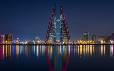
Discovering the Hidden Gems of Bahrain: A Guide to the Kingdom’s Best-Kept Secrets
Bahrain, a small island nation in the Arabian Gulf, may not be the first destination that comes to mind when planning a trip. However, this hidden gem is filled with rich history, stunning natural landscapes, vibrant neighborhoods, delicious cuisine, a thriving art scene, and much more. In this article, we will delve into the lesser-known attractions and experiences that make Bahrain a truly unique and captivating travel destination. Key Takeaways Bahrain has many hidden gems waiting to be discovered by tourists. Exploring ancient sites and museums is a great way to learn about Bahrain’s rich history. Bahrain’s unique landscapes, including its desert and coral reefs, are worth exploring. Venturing off the beaten path to explore lesser-known neighborhoods can lead to unexpected discoveries. Bahrain’s culinary scene offers many hidden treasures, including traditional dishes and street food. The Rich History of Bahrain: Exploring Ancient Sites and Museums Bahrain has a fascinating history that dates back thousands of years. It was once an important trading hub in the ancient world and has been inhabited since prehistoric times. Today, visitors can explore the remnants of this rich history through the various ancient sites and museums scattered across the island. One of the must-visit historical sites in Bahrain is the Bahrain Fort, also known as Qal’at al-Bahrain. This UNESCO World Heritage Site is an archaeological site that showcases the ancient Dilmun civilization. Visitors can explore the ruins of the fort and learn about its significance through the onsite museum. Another historical site worth visiting is the Barbar Temple. This ancient temple dates back to the Dilmun era and is one of the largest and...

Discover the Hidden Gems of the Bahamas: A Guide to the Best-Kept Secrets of this Caribbean Paradise
The Bahamas is a popular tourist destination known for its stunning beaches, crystal-clear waters, and vibrant culture. However, beyond the well-known tourist spots, there are hidden gems waiting to be discovered. Exploring the lesser-known areas of the Bahamas allows travelers to experience a different side of this beautiful country and uncover its hidden treasures. Key Takeaways The Bahamas has many hidden treasures waiting to be discovered beyond the popular tourist spots. Exploring the lesser-known islands and cays of the Bahamas offers a unique and off-the-beaten-path experience. Immerse yourself in the local culture and traditions of the Bahamas for a truly authentic experience. The Bahamas’ national parks and reserves offer breathtaking natural wonders to explore. Diving and snorkeling in the Bahamas’ secret spots reveal a whole new world of underwater adventures. Off-the-Beaten-Path: Exploring the Hidden Islands and Cays of the Bahamas While Nassau and Paradise Island are the most well-known destinations in the Bahamas, there are many other islands and cays that offer a more secluded and authentic experience. For example, the Exumas is a chain of islands known for its pristine beaches, turquoise waters, and abundant marine life. The Exumas also offer unique attractions such as swimming with pigs on Big Major Cay or exploring Thunderball Grotto, a cave system made famous by the James Bond film. Another hidden gem is Andros Island, the largest island in the Bahamas. Andros is known for its untouched natural beauty, including vast wetlands, mangrove forests, and blue holes. It is also home to the third-largest barrier reef in the world, making it a paradise for snorkelers and divers. Cultural Delights: Discovering the...
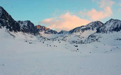
Discovering the Hidden Gem of Europe: Exploring the Beauty of Andorra
Nestled in the eastern Pyrenees mountains between France and Spain, Andorra is a small principality that often goes unnoticed by travelers. With a population of just over 77,000 people, Andorra is one of the smallest countries in Europe. Despite its size, Andorra offers a unique and unforgettable experience for those who venture to this hidden gem. Andorra’s history dates back to the 9th century when it was established as a co-principality by the Bishop of Urgell and the Count of Foix. Over the centuries, Andorra has maintained its independence and unique political system, making it one of the oldest democracies in the world. Today, Andorra is known for its stunning natural landscapes, rich cultural heritage, and world-class ski resorts. Key Takeaways Andorra is a hidden gem in Europe, offering a unique blend of culture, natural beauty, and outdoor activities. The country has a rich history and culture, with unique architecture and landmarks to explore. Andorra’s mountains, lakes, and scenic landscapes make it a perfect destination for hiking and outdoor activities. The country is also known for its ski resorts and winter sports, making it a popular destination for winter vacations. Andorra offers a blend of tradition and modernity, with shopping, dining, and festivals that celebrate its unique culture and heritage. Andorra’s Rich Culture and History One of the most fascinating aspects of Andorra is its rich cultural heritage, heavily influenced by Catalan culture. Catalan is the official language of Andorra, and many of its traditions and customs are deeply rooted in Catalan traditions. From its cuisine to its festivals, visitors to Andorra will experience a unique blend of Catalan...
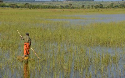
Exploring the Rich Culture and Natural Wonders of Angola: A Journey Through the Heart of Africa
Located on the west coast of Southern Africa, Angola is a country known for its rich cultural heritage, diverse landscapes, and warm and welcoming people. With a history that dates back thousands of years, Angola has a unique blend of African, Portuguese, and indigenous influences that can be seen in its art, music, cuisine, and architecture. From the bustling capital city of Luanda to the remote villages and stunning natural wonders, Angola offers a wealth of experiences for travelers seeking adventure, culture, and relaxation. Angola’s history is a complex tapestry of colonization, independence struggles, and post-war reconstruction. The country gained independence from Portugal in 1975 after a long and bloody war. Since then, Angola has made great strides in rebuilding its infrastructure and developing its economy. Today, it is one of the fastest-growing economies in Africa and has become an increasingly popular destination for tourists looking to explore its unique attractions. Key Takeaways Angola is a diverse and beautiful country with rich cultural heritage and natural wonders. The country’s national parks and wildlife reserves offer a unique opportunity to explore its wildlife and landscapes. Angola’s music and dance scene is vibrant and worth experiencing. The country’s cuisine and local delicacies are delicious and worth sampling. Angola’s friendly people offer a warm welcome to visitors. Discovering the Rich Cultural Heritage of Angola Angola is home to a diverse range of ethnic groups, each with their own unique traditions and customs. From the Ovimbundu in the central highlands to the Bakongo in the north and the Ovambo in the south, Angola’s cultural heritage is as diverse as its landscapes. Visitors to...
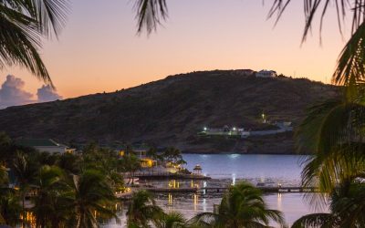
Discovering the Hidden Gems of Antigua and Barbuda: A Caribbean Paradise Awaits
Antigua and Barbuda is a small island nation located in the Caribbean Sea. It consists of two main islands, Antigua and Barbuda, along with several smaller islands. The country has a rich history and vibrant culture, with influences from its indigenous people, European colonizers, and African slaves. Today, Antigua and Barbuda is known for its stunning beaches, crystal-clear waters, and warm hospitality, making it a popular destination for tourists from around the world. Antigua and Barbuda’s location in the Caribbean makes it an ideal vacation spot for those seeking sun, sand, and relaxation. The islands are situated in the northeastern part of the Caribbean Sea, just east of Puerto Rico. With its tropical climate and average temperatures ranging from 75 to 85 degrees Fahrenheit year-round, Antigua and Barbuda offer perfect beach weather no matter when you visit. The country’s history dates back thousands of years, with evidence of indigenous settlements on the islands as early as 2400 BC. European colonization began in the 16th century when Christopher Columbus arrived in 1493. The islands were later colonized by the British in the 17th century and remained under British rule until gaining independence in 1981. This colonial history is still evident today in the architecture, language, and cultural traditions of Antigua and Barbuda. Key Takeaways Antigua and Barbuda is a stunning Caribbean paradise with beautiful beaches, rich culture, and diverse wildlife. The best beaches in Antigua and Barbuda are hidden gems waiting to be explored, offering crystal-clear waters and white sand. The local traditions and festivals of Antigua and Barbuda are a must-see, showcasing the island’s vibrant culture and history. The...
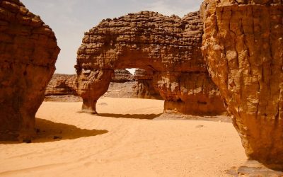
Discovering the Hidden Gems of Algeria: A Journey Through its Rich Culture and History
Algeria, located in North Africa, is a country that is often overlooked when it comes to tourism. However, this beautiful and diverse nation is home to a wealth of hidden treasures that are waiting to be discovered. From its rich cultural heritage to its stunning natural landscapes, Algeria has something to offer every traveler. In this article, we will delve into the various aspects of Algeria’s hidden gems and explore why it is important to promote and embrace these treasures. Algeria’s tourism industry has long been overshadowed by its neighboring countries such as Morocco and Tunisia. However, in recent years, there has been a growing interest in exploring the hidden gems of Algeria. This is due in part to the country’s efforts to promote its tourism industry and showcase its unique attractions. By uncovering Algeria’s hidden treasures, we not only contribute to the growth of its tourism sector but also gain a deeper understanding and appreciation for the country’s rich history, culture, and natural beauty. Key Takeaways Algeria has a rich cultural heritage that includes indigenous peoples, Islamic art and architecture, Berber kingdoms, Roman ruins, traditional crafts, vibrant music and dance, delicious cuisine, and stunning desert landscapes. Algeria’s indigenous peoples have a unique culture and history that is worth exploring and preserving. Islamic art and architecture have left a lasting impact on Algeria’s cities and landmarks, showcasing the country’s rich history and heritage. The Berber kingdoms of Algeria have a fascinating history that is still being uncovered and studied today. Algeria’s ancient cities and Roman ruins offer a glimpse into the country’s past and are a must-see for history...
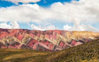
Exploring the Enchanting Wonders of Argentina: A Journey Through Its Vibrant Culture and Breathtaking Landscapes
Argentina, located in the southern part of South America, is a country known for its vast and diverse landscapes, rich culture, and passionate people. With an area of over 2.7 million square kilometers, Argentina is the eighth-largest country in the world. It is bordered by Chile to the west, Bolivia and Paraguay to the north, Brazil to the northeast, and Uruguay and the Atlantic Ocean to the east. The country’s geography ranges from the towering Andes Mountains in the west to the fertile plains of the Pampas in the center, and from the stunning glaciers of Patagonia in the south to the tropical rainforests of the northeast. Argentina is a melting pot of different cultures and influences. The majority of its population is of European descent, with a strong influence from Spain and Italy. However, there are also significant indigenous populations, as well as communities with African, Middle Eastern, and Asian roots. This diversity is reflected in Argentina’s cuisine, music, dance, art, and literature. Argentina plays a crucial role in South America both economically and politically. It is one of the largest economies in the region and has a strong agricultural sector, producing crops such as soybeans, corn, wheat, and beef. The country is also known for its natural resources, including oil, gas, and minerals. In addition to its economic importance, Argentina has been a key player in regional politics and has had a significant influence on South American culture. Key Takeaways Argentina is a diverse and beautiful country with a rich culture and fascinating history. The music, dance, and art of Argentina are colorful and vibrant, reflecting the...
Discovering the Hidden Gems of Albania: A Journey Through the Land of Eagles
Nestled in the Balkan Peninsula, Albania is a country that often goes unnoticed by travelers. However, this hidden gem is a land of rich culture and history, waiting to be explored. With its stunning landscapes, ancient ruins, unique cuisine, and warm hospitality, Albania offers a truly unique travel experience. Albania is located in Southeastern Europe, bordered by Montenegro to the northwest, Kosovo to the northeast, North Macedonia to the east, Greece to the south, and the Ionian Sea to the west. The country has a long and complex history, with influences from the Illyrians, Romans, Byzantines, Ottomans, and Communists. This rich history is reflected in its architecture, traditions, and cultural heritage. What sets Albania apart as a travel destination is its authenticity. Unlike some other European countries that have become overrun with tourists, Albania remains relatively untouched by mass tourism. This means that visitors can experience the country’s natural beauty and cultural treasures in a more intimate and authentic way. From its stunning mountains and pristine beaches to its ancient ruins and vibrant cities, Albania has something for every type of traveler. Key Takeaways Albania is a country with a rich culture and history that is waiting to be explored. The natural wonders of Albania, including its mountains, beaches, and lakes, are breathtaking and worth visiting. Albania is home to ancient ruins and architectural marvels that offer a glimpse into its past. The unique cuisine and local delicacies of Albania are a must-try for any food lover. The warm and welcoming people of Albania make it a great destination for travelers. Uncovering the Natural Wonders of Albania: Mountains, Beaches...
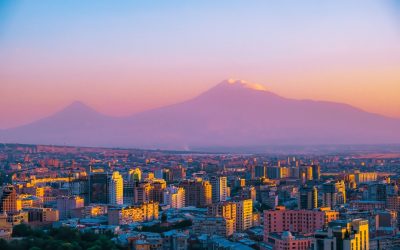
Discovering the Rich Culture and History of Armenia: A Journey Through Time
Armenia, located in the South Caucasus region of Eurasia, is a country with a rich and vibrant culture that dates back thousands of years. Nestled between Turkey, Georgia, Azerbaijan, and Iran, Armenia has a unique blend of influences from both the East and the West. Throughout its history, Armenia has faced numerous challenges and hardships, but its people have always managed to preserve their cultural heritage and celebrate their identity. The history of Armenia can be traced back to ancient times, with evidence of human habitation dating back to the Neolithic period. The ancient Armenian civilization flourished during the Bronze Age and Iron Age, with the Kingdom of Urartu being one of its most prominent states. The Armenians have a long and storied history, with key events such as the adoption of Christianity as the state religion in 301 AD and the Armenian Genocide in 1915 shaping their identity. Preserving and celebrating Armenian heritage is of utmost importance to the Armenian people. It serves as a reminder of their resilience and strength in the face of adversity. It also helps to foster a sense of unity and pride among Armenians around the world. By understanding and appreciating their rich culture and history, Armenians are able to pass down their traditions and values to future generations. Key Takeaways Armenia has a rich culture and history that spans thousands of years. The ancient civilization of Armenia has left behind impressive architectural and artistic achievements. Religion has played a significant role in shaping Armenian culture and society. Armenian cuisine is a delicious blend of traditional and innovative flavors. Armenian music, dance, literature,...
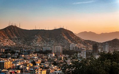
Uncovering the Beauty and Complexity of Afghanistan: Exploring the Rich Culture and History of the Land of the Afghans
Afghanistan, a landlocked country in Central Asia, has a rich and diverse cultural heritage that spans thousands of years. From its ancient history to its modern struggles, Afghanistan has a story to tell that is both fascinating and complex. Learning about Afghanistan’s culture and history is important for several reasons. It helps us understand the country’s present-day challenges, appreciate its contributions to art and literature, and foster a sense of empathy and connection with its people. Key Takeaways Afghanistan has a rich cultural heritage that spans thousands of years. The country’s traditional crafts, such as pottery and carpet weaving, are renowned for their beauty and quality. Afghan cuisine is diverse and delicious, with influences from neighboring countries and unique local ingredients. Afghanistan’s natural beauty is breathtaking, with stunning landscapes ranging from snow-capped mountains to lush valleys. Afghan music and dance are an important part of the country’s cultural identity, reflecting its diverse traditions and history. The Land of the Afghans: A Brief Introduction to Afghanistan Afghanistan is located in the heart of Asia, bordered by Iran to the west, Pakistan to the east and south, Turkmenistan, Uzbekistan, and Tajikistan to the north, and China to the northeast. It is a landlocked country with a diverse landscape that includes mountains, deserts, and fertile valleys. The Hindu Kush mountain range runs through the country, providing breathtaking views and challenging terrain. The population of Afghanistan is estimated to be around 38 million people, consisting of various ethnic groups. The largest ethnic group is the Pashtuns, followed by Tajiks, Hazaras, Uzbeks, and others. Each ethnic group has its own distinct culture, traditions, and...
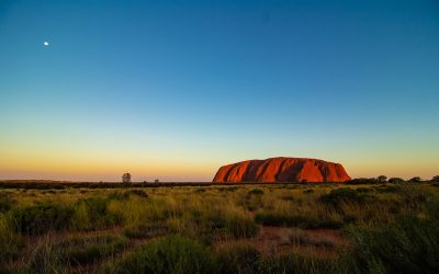
Discovering Australia: A Journey Through the Land Down Under
Australia, the world’s sixth-largest country, is a land of incredible diversity and natural beauty. Located in the southern hemisphere, it is surrounded by the Indian and Pacific Oceans, with stunning coastlines stretching for thousands of kilometers. The country is known for its unique wildlife, vibrant cities, and breathtaking landscapes. From the iconic Sydney Opera House to the vast Outback, Australia offers a wide range of experiences for travelers. Tourism plays a significant role in the Australian economy, contributing billions of dollars each year. The country attracts millions of visitors who come to explore its natural wonders, experience its rich culture, and enjoy its warm hospitality. With its diverse range of attractions and activities, Australia has something to offer every type of traveler. Key Takeaways Australia is a diverse and beautiful country with a rich indigenous culture and unique wildlife. Understanding and respecting the culture of the First Australians is an important part of experiencing Australia. The Great Barrier Reef is the world’s largest coral reef system and a must-see destination for any traveler. The Outback is the heart of Australia and offers a unique and rugged landscape to explore. Meeting kangaroos, koalas, and other Australian wildlife is a highlight of any trip to Australia. Indigenous Culture: Understanding the First Australians Australia’s Indigenous culture is one of the oldest living cultures in the world, dating back over 65,000 years. The Aboriginal people have a deep connection to the land and have a rich history and heritage that is still celebrated today. Understanding and experiencing Aboriginal culture is an important part of any visit to Australia. There are many ways to...
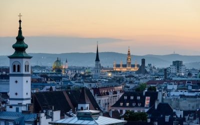
Discovering the Charms of Austria: A Traveler’s Guide to the Best Sights and Experiences
Austria is a country known for its natural beauty and cultural richness. Nestled in the heart of Europe, this small country is home to stunning alpine landscapes, charming cities, and a rich history that has influenced music, art, and architecture. From the imperial grandeur of Vienna to the alpine wonders of the Austrian Alps, there is something for everyone to explore and discover in Austria. Key Takeaways Austria is a country of natural beauty and cultural richness. Vienna is a city of music, art, and architecture with imperial history. The Austrian Alps offer skiing, hiking, and relaxation opportunities. Salzburg is the birthplace of Mozart and the setting of The Sound of Music. The Danube Valley is a scenic journey through Austria’s wine country. Exploring Vienna Vienna, the capital city of Austria, is a must-visit destination for any traveler. Known for its imperial history, Vienna was once the center of the Habsburg Empire and its influence can still be seen today in the city’s architecture and cultural offerings. The city is home to numerous palaces, museums, and concert halls that showcase its rich history. One of the must-see sights in Vienna is Schönbrunn Palace. This magnificent palace was once the summer residence of the Habsburgs and is now a UNESCO World Heritage site. Visitors can explore the palace’s opulent rooms, stroll through its beautiful gardens, and even catch a classical concert in the Orangery. Another iconic sight in Vienna is St. Stephen’s Cathedral. This stunning Gothic cathedral is located in the heart of the city and is known for its intricate architecture and beautiful stained glass windows. Visitors can climb...