Explore the World Through Geography, Natural Resources & Daily History
Clear, reliable and engaging guides that help you understand our planet — from UK geography education to global natural resources and On This Day history events.
Explore, discover, and learn about the wonders of our world! At Earth Site, we’re passionate about bringing geography, history, and science to life for curious minds of all ages. Whether you’re delving into historical events, uncovering the mysteries of the natural world, or seeking interactive resources, you’re in the right place.
Here, you can uncover the stories behind historical events, explore the natural wonders of our planet, and gain valuable insights into how the Earth’s systems shape our daily lives. From the towering peaks of mountain ranges to the far-reaching impacts of human innovation, we aim to make every topic both engaging and informative.
Start your journey of discovery with us today, and let’s make learning an adventure!
What We Cover
Earth Site brings together engaging and accessible educational content designed to help you understand the world, its history, and its natural systems.
🌍 Geography Education (UK & Worldwide)
We publish clear, easy-to-understand geography resources for students, teachers and curious learners. Our guides support geography education in the UK and cover physical geography, climate, ecosystems, population, and global development.
⛏️ Natural Resources & Environmental Geography
Explore detailed country profiles covering natural resources, mining, energy, geology and global environmental challenges. We show how nations manage minerals, water, land and ecosystems, and why these resources matter.
📅 On This Day in History
Every day has a story. Our On This Day history series features major events, anniversaries, traditions, and cultural milestones from around the world — with timelines, context, and fun facts.
TIMELINE

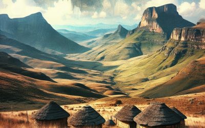
Terrain and Topography of Lesotho: mountains, valleys, and plains.
Lesotho, also known as the Kingdom in the Sky, is a landlocked country situated in southern Africa. The nation boasts diverse and striking terrain and topography that has attracted numerous travellers and adventurers. Lesotho‘s terrain is characterised by its rugged and mountainous landscape, with the entire country positioned at a high altitude. The topography of Lesotho is dominated by the Drakensberg Mountains, which extend along the eastern border of the country, and the Maloti Mountains, which stretch into the central and western regions. These imposing mountains are complemented by scenic valleys and expansive plains, creating a landscape that is both awe-inspiring and distinctive. Lesotho’s terrain and topography have significantly influenced the country’s climate, environment, culture and economy. The impact of the diverse terrain and topography is evident in its influence on the climate, support of rich biodiversity and shaping of the traditional way of life of the Basotho people. Moreover, the rugged landscape has presented both conservation challenges and opportunities for sustainable development. This article will explore the various aspects of Lesotho’s terrain and topography, from its majestic mountains to its vast plains, and examine how they have shaped the country’s climate, environment, culture and economy. Summary Lesotho’s terrain is characterized by rugged mountains, picturesque valleys, and vast plains. The majestic mountains of Lesotho, including the Drakensberg and Maloti ranges, offer stunning landscapes and challenging hiking opportunities. The picturesque valleys of Lesotho, such as the Maseru Valley, are home to fertile lands and traditional villages. The vast plains of Lesotho, known as the Lowlands, are important for agriculture and livestock grazing. The terrain and topography of Lesotho greatly influence...

History of Lesotho
Lesotho, a landlocked country in Southern Africa, possesses a rich history dating back to early settlements and kingdoms. The earliest inhabitants of the region were the San people, who were hunter-gatherers and occupied the area for thousands of years. Subsequently, Bantu-speaking people migrated into the region, introducing iron-working skills and agricultural techniques. These Bantu-speaking people formed various chiefdoms and kingdoms, including the Sotho-Tswana kingdoms, which were established in the 17th century. The Sotho-Tswana kingdoms were renowned for their skilled farming and cattle herding, and they developed complex social and political structures. One of the most powerful of these kingdoms was the Kingdom of Lesotho, founded by King Moshoeshoe I in the early 19th century. King Moshoeshoe I was an adept diplomat and military strategist who successfully united various Sotho-Tswana chiefdoms to form the Kingdom of Lesotho. His kingdom became a sanctuary for refugees fleeing from the conflicts and wars in surrounding regions, and it grew into a powerful and prosperous state. The early settlements and kingdoms in Lesotho established the foundation for the country’s rich cultural heritage and traditions. The legacy of King Moshoeshoe I and the Sotho-Tswana kingdoms continues to be commemorated in Lesotho today, and their influence is evident in the country’s language, customs, and social structures. Summary Early settlements in Lesotho date back to the 19th century, with the establishment of various kingdoms and chiefdoms. European explorers arrived in the 19th century, leading to colonization by the British and the Dutch. Lesotho gained independence from Britain in 1966 and became a constitutional monarchy, forming the Kingdom of Lesotho. Political turmoil and struggle for democracy have been...

Natural Resources of Lesotho: Where Natural Resources are Located in Lesotho
Lesotho, a small landlocked country in Southern Africa, possesses a variety of natural resources that contribute to its economic development and sustenance of livelihoods. The country’s natural resources encompass water, minerals, agriculture, forestry and energy. These resources play a crucial role in the nation’s economy, providing employment opportunities, supporting livelihoods and contributing to overall development. Lesotho‘s natural resources are not only valuable for the country’s economy but also for its people, who rely on these resources for their daily needs and sustenance. The sustainable management and conservation of these natural resources are essential to ensure their availability for future generations and to support the country’s long-term development. Lesotho’s natural resources are diverse and abundant, providing the country with a solid foundation for economic growth and development. The country’s unique geographical location and topography contribute to the richness of its natural resources. With its high mountains, deep valleys and abundant water sources, Lesotho is well-endowed with natural resources that have the potential to drive economic growth and improve the livelihoods of its people. However, the sustainable management and conservation of these resources are crucial to ensure their long-term availability and to mitigate the impact of environmental degradation. Lesotho’s natural resources are a vital asset for the country, and their sustainable management is essential for the country’s future development and prosperity. Summary Lesotho is rich in natural resources, including water, minerals, agriculture, forestry, and energy. The water resources in Lesotho are abundant and have the potential for hydropower generation and irrigation. Lesotho has significant mineral resources, including diamonds, sandstone, and clay. Agriculture is a key sector in Lesotho, with a focus...

Cultural or Historical Sites of Lesotho: Important Cultural Landmarks or Historical Sites in Lesotho
Lesotho, a small landlocked country in Southern Africa, possesses a rich cultural and historical heritage. The nation is home to diverse cultural and historical sites that provide insight into the fascinating past of the Basotho people. From ancient cave dwellings to imposing mountain fortresses, Lesotho‘s cultural and historical sites stand as a testament to the resilience and ingenuity of its inhabitants. These locations offer visitors a unique opportunity to explore Lesotho’s rich history and heritage, and to gain a deeper understanding of the traditions and customs that have shaped the country’s identity. Lesotho’s cultural and historical sites are of great significance not only to the Basotho people but also to the wider global community. These sites offer a window into the prehistoric past of Southern Africa and provide valuable insights into the region’s ancient civilisations and cultures. As such, they are important not only for their cultural and historical significance but also for their potential to contribute to our understanding of human history as a whole. This article will explore some of the most notable cultural and historical sites in Lesotho and examine the stories and significance behind each of these remarkable locations. Summary Lesotho is home to a rich cultural and historical heritage, with a variety of sites that showcase the country’s unique past. Thaba-Bosiu, the mountain fortress of King Moshoeshoe I, is a significant historical site that offers stunning views and insights into Lesotho’s history. The Morija Museum and Archives is a must-visit for those interested in Basotho culture and history, with a wide range of artefacts and documents on display. The Ha Kome Cave Dwellings provide...

Population Density of Lesotho
Lesotho, a landlocked country in Southern Africa, is characterised by its high population density. With a population exceeding 2 million people and a land area of merely 30,355 square kilometres, Lesotho boasts one of the highest population densities globally. The majority of the populace is concentrated in the lowlands, particularly in the capital city of Maseru and surrounding urban areas. The high population density in Lesotho presents both challenges and opportunities for the country, affecting its infrastructure, resources, and overall development. Understanding the factors contributing to this high population density and its implications is crucial for policymakers and stakeholders in Lesotho. Lesotho’s population density is a result of various historical, social, and economic factors. The country has a predominantly rural population, with agriculture serving as the primary source of livelihood for many people. The limited availability of arable land in the mountainous terrain has led to population concentration in the lowlands, where farming is more viable. Furthermore, Lesotho has a high population growth rate, further exacerbating the pressure on land and resources. The impact of HIV/AIDS has also contributed to the demographic landscape, with a significant number of orphans and vulnerable children requiring support and care. These factors have collectively contributed to Lesotho’s high population density, shaping the country’s social and economic dynamics. Summary Lesotho has one of the highest population densities in Africa, with over 70% of its population living in rural areas. Factors contributing to Lesotho’s high population density include limited arable land, high fertility rates, and a lack of urbanisation. High population density in Lesotho puts a strain on infrastructure, healthcare, and natural resources, leading to...
Lesotho
Lesotho (Musa oa Lesotho (Sotho); Kingdom of Lesotho (English)) Capital: Maseru Population (Estimated July 2012): 1,930,493 Area: 30,355 km2 or 11,720 mi2 Currency: Loti (Plural Maloti [M]) Official Language: Sotho and English Political Information: Constitutional Monarchy and Parliamentary Democracy Official Religion: Christianity(approximately 80% of the population are Christian and 20% have Indigenous religious beliefs) Highest Mountain: Thabana Ntlenyana Mountain at 3,482 m or 11,424 ft GDP Official Exchange Rate (OER is more precise at gauging a country’s economic power) (Estimated 2011): $2.7 billion (US$) or (GBP) GDP (OER) Per Capita (per member of the population estimated 2011): (US$) or (GBP) GDP Purchasing Power Parity (PPP is good for gauging living conditions and the use of resources but is not as accurate as OER. This data has been calculated based on the sum value of all goods and services produced in the country valued at prices prevailing in the United States) (Estimated 2011): $3.672 billion (US$) or (GBP) GDP (PPP) Per Capita (per member of the population estimated 2011): $1,400 (US$) or (GBP) Time Zone (GMT/UTC): +2:00 Wildlife: Counties/Provinces/States: 10 districts; Berea, Butha-Buthe, Leribe, Mafeteng, Maseru, Mohale’s Hoek, Mokhotlong, Qacha’s Nek, Quthing, Thaba-Tseka Leaders: King Letsie III with Prime Minister Thomas Motsoahae Thabane. Additional: Gained Independence from the UK on the 4th of October 1966. Sources: CIA World Fact Book, Encyclopaedia Britannica. Lesotho Lesotho, officially the Kingdom of Lesotho, is a landlocked country situated in southern Africa. It is entirely encircled by South Africa, making it one of the few nations globally that is completely surrounded by another country. Maseru serves as the capital and largest city of Lesotho. The country boasts a population of approximately 2 million inhabitants, with Sesotho and English...

Political Boundaries of Lebanon: Provinces, Districts, or Historical Boundaries.
Lebanon, a small nation situated in the Middle East, is characterised by its intricate political boundaries. The country shares borders with Syria to the north and east, Israel to the south, and the Mediterranean Sea to the west. Lebanon‘s political boundaries have been moulded by a protracted history of conflict and conquest, resulting in a diverse landscape of governorates and districts. The evolution of these boundaries reflects the influence of various empires and colonial powers that have governed the region. Presently, Lebanon is divided into eight governorates and 25 districts, each possessing its own distinct cultural, historical, and political significance. The political boundaries of Lebanon have been instrumental in shaping the nation’s identity and governance. The varied landscape of governorates and districts mirrors the complex social and political dynamics that have influenced Lebanon’s history. A thorough understanding of Lebanon’s political boundaries is crucial for comprehending the country’s intricate political landscape and the challenges it currently faces. This article will examine the governorates and districts of Lebanon, as well as the historical boundaries that have shaped the country’s political terrain. Additionally, it will explore the challenges and controversies surrounding Lebanon’s political boundaries and discuss their future in light of the nation’s ongoing political and social developments. Summary Lebanon’s political boundaries are defined by its borders with Syria to the north and east, Israel to the south, and the Mediterranean Sea to the west. The country is divided into 8 provinces, each with its own distinct characteristics and cultural significance. Within these provinces, there are 25 districts, each with its own administrative and political significance. Lebanon’s historical boundaries have evolved over...

Climate Zones Of Lebanon: Different Climate Regions Of Lebanon
Lebanon, a diminutive nation situated on the eastern shore of the Mediterranean Sea, boasts a remarkably diverse array of climate zones despite its modest size. These distinct zones each possess unique characteristics that significantly influence the local environment and agricultural practices. The country’s climate is profoundly shaped by its geographical position, with the Mediterranean Sea bordering its western coast, the Lebanon Mountains extending parallel to the shoreline, and the Anti-Lebanon Mountains rising to the east. This varied topography engenders a multifaceted landscape, resulting in the formation of distinct climate zones across the country. A comprehensive understanding of these climate zones is essential for appreciating Lebanon’s biodiversity and agricultural methodologies, as each zone presents its own particular set of challenges and opportunities for both flora and fauna. Summary Lebanon has diverse climate zones, including the Mediterranean climate of coastal areas, the mountainous climate of the Lebanon Mountains, the continental climate of the Beqaa Valley, the semi-arid climate of the Anti-Lebanon Mountains, and the desert climate of the Eastern Border. The Mediterranean climate of coastal areas is characterized by hot, dry summers and mild, wet winters, making it suitable for the cultivation of citrus fruits, olives, and vineyards. The mountainous climate of the Lebanon Mountains experiences cooler temperatures and higher precipitation, supporting the growth of cedar forests and diverse wildlife. The Beqaa Valley has a continental climate with hot summers and cold winters, ideal for the cultivation of wheat, barley, and fruits such as apples and pears. The semi-arid climate of the Anti-Lebanon Mountains and the desert climate of the Eastern Border pose challenges for agriculture, but they are home to...

Cultural or Historical Sites of Lebanon: Important Cultural Landmarks or Historical Sites in Lebanon
The ancient city of Byblos, situated on the Mediterranean coast of Lebanon, is a UNESCO World Heritage Site with a history spanning over 7,000 years. It is recognised as one of the oldest continuously inhabited cities globally, boasting a rich heritage encompassing Phoenician, Roman, and Ottoman periods. Byblos is renowned for its well-preserved archaeological sites, including the Temple of Baalat Gebal, the Royal Necropolis, and the Phoenician city walls. The city served as a significant trading hub for the ancient Phoenicians and played a crucial role in the development of the alphabet. Byblos is also home to the impressive Crusader Castle, constructed during the 12th century, which offers panoramic views of the surrounding area. Visitors to Byblos can explore the ancient ruins, wander through the charming old town, and enjoy the beautiful beaches, making it an essential destination for history enthusiasts and beachgoers alike. Byblos is a repository of historical and archaeological marvels, with each layer of civilisation contributing to its allure. The Phoenician influence is particularly evident in the city’s architecture, characterised by distinctive stone walls and temples. The Roman period has also left its mark on Byblos, as evidenced by the well-preserved Roman amphitheatre and the remains of a Roman street. The city’s rich history is brought to life in the numerous museums and cultural institutions that showcase artefacts and relics from Byblos’ past. The vibrant atmosphere of the modern town, with its bustling souks and lively waterfront, provides a stark contrast to the ancient ruins, creating a unique blend of old and new that is certain to captivate visitors. Byblos stands as a living testament to...

Natural Resources of Lebanon: Where Natural Resources are Located in Lebanon
Lebanon is a small country situated on the eastern coast of the Mediterranean Sea. Despite its diminutive size, Lebanon possesses a wealth of natural resources that have significantly influenced the nation’s economy and environment. The varied terrain of Lebanon encompasses mountains, valleys and coastal regions, which contribute to the abundance of natural resources found within the country. From water resources to forests, minerals, energy, agriculture, and marine and coastal resources, Lebanon’s natural wealth has been a source of sustenance and economic development for centuries. Lebanon’s natural resources have been both a boon and a challenge for the country. The exploitation of these resources has resulted in environmental degradation and depletion, threatening the sustainability of these valuable assets. However, efforts to conserve and sustainably manage Lebanon’s natural resources have gained traction in recent years, with the aim of protecting the environment and ensuring the long-term availability of these resources for future generations. This article will examine the various natural resources found in Lebanon, their importance, and the ongoing efforts to conserve and sustainably manage them. Summary Lebanon is rich in natural resources, including water, forests, minerals, energy, agriculture, and marine and coastal resources. The water resources in Lebanon are under pressure due to pollution, over-extraction, and climate change, leading to water scarcity in some areas. Lebanon’s forests and biodiversity are threatened by deforestation, urbanization, and unsustainable land use practices. The country has significant mineral and energy resources, including limestone, gypsum, and potential for oil and gas exploration. Agriculture is a key sector in Lebanon, but it faces challenges such as soil degradation, water scarcity, and limited arable land. Water Resources...

Terrain and Topography of Lebanon: mountains, valleys, and plains.
Lebanon, a small country situated in the Middle East, is renowned for its diverse and striking terrain and topography. The nation is bordered by the Mediterranean Sea to the west, which has significantly influenced its landscape. Lebanon‘s terrain is characterised by its rugged mountains, fertile valleys, and scenic plains, rendering it a unique and beautiful destination for nature enthusiasts and adventure seekers. The topography of Lebanon is a result of tectonic activity and erosion over millions of years, creating a landscape that is both awe-inspiring and challenging to traverse. From the snow-capped peaks of the mountains to the lush green valleys and coastal plains, Lebanon’s terrain and topography offer a rich tapestry of natural beauty that merits exploration and conservation. Lebanon’s terrain and topography have played a crucial role in shaping the country’s history, culture, and economy. The diverse landscape has provided natural barriers and resources that have influenced the development of settlements, agriculture, and trade routes. The mountains have served as a refuge for various ethnic and religious groups throughout history, whilst the fertile valleys have supported agricultural activities and sustained communities. The coastal plains have facilitated trade and commerce, connecting Lebanon to the wider Mediterranean region. Understanding Lebanon’s terrain and topography is essential for appreciating the country’s rich heritage and for addressing the environmental and developmental challenges it faces. This article will delve into the different aspects of Lebanon’s terrain and topography, exploring its mountains, valleys, plains, climate, agriculture, and the importance of preserving its diverse landscape. Summary Lebanon’s terrain and topography are diverse and varied, ranging from mountains to valleys and plains. The majestic mountains of...

History of Lebanon
Lebanon boasts a rich and diverse history, with evidence of human habitation dating back to the Palaeolithic period. The region was home to several ancient civilisations, including the Phoenicians, who were renowned for their seafaring and trading prowess. The Phoenicians established city-states along the coast, such as Tyre, Sidon, and Byblos, and were celebrated for their production of purple dye and cedar wood. The Phoenician alphabet, which later evolved into the Greek and Latin alphabets, was another significant contribution to world culture. In addition to the Phoenicians, Lebanon was also part of the Assyrian, Babylonian, Persian, Hellenistic, Roman, and Byzantine empires. Each of these civilisations left their mark on the region, with impressive archaeological sites such as Baalbek, an ancient Roman city with some of the largest and best-preserved Roman ruins in the world. The diversity of Lebanon’s ancient history is reflected in its UNESCO World Heritage Sites, which include the ruins of Anjar, Byblos, and Tyre. These sites attract tourists from around the world who come to marvel at the ancient architecture and learn about the rich history of the region. Summary Ancient civilizations in Lebanon date back to at least 7000 BC, with evidence of Phoenician, Roman, and Byzantine influence still visible today. Lebanon was under Ottoman rule from the 16th century until the aftermath of World War I, when it came under French mandate. The French mandate and subsequent independence in 1943 marked a turning point in Lebanon’s history, leading to the establishment of a unique political system based on religious representation. The Lebanese Civil War, which lasted from 1975 to 1990, had a devastating impact...