Explore the World Through Geography, Natural Resources & Daily History
Clear, reliable and engaging guides that help you understand our planet — from UK geography education to global natural resources and On This Day history events.
Explore, discover, and learn about the wonders of our world! At Earth Site, we’re passionate about bringing geography, history, and science to life for curious minds of all ages. Whether you’re delving into historical events, uncovering the mysteries of the natural world, or seeking interactive resources, you’re in the right place.
Here, you can uncover the stories behind historical events, explore the natural wonders of our planet, and gain valuable insights into how the Earth’s systems shape our daily lives. From the towering peaks of mountain ranges to the far-reaching impacts of human innovation, we aim to make every topic both engaging and informative.
Start your journey of discovery with us today, and let’s make learning an adventure!
What We Cover
Earth Site brings together engaging and accessible educational content designed to help you understand the world, its history, and its natural systems.
🌍 Geography Education (UK & Worldwide)
We publish clear, easy-to-understand geography resources for students, teachers and curious learners. Our guides support geography education in the UK and cover physical geography, climate, ecosystems, population, and global development.
⛏️ Natural Resources & Environmental Geography
Explore detailed country profiles covering natural resources, mining, energy, geology and global environmental challenges. We show how nations manage minerals, water, land and ecosystems, and why these resources matter.
📅 On This Day in History
Every day has a story. Our On This Day history series features major events, anniversaries, traditions, and cultural milestones from around the world — with timelines, context, and fun facts.
TIMELINE

Terrain and Topography of Denmark: mountains, valleys, and plains.
Denmark, located in Northern Europe, is a country known for its unique terrain and topography. Situated on the Jutland Peninsula and numerous islands, Denmark offers a diverse landscape that ranges from low-lying landscapes to rolling hills and coastal features. Understanding Denmark’s geography is essential for both visitors and locals, as it plays a significant role in shaping the country’s infrastructure, history, culture, and way of life. Summary Denmark’s terrain and topography are unique and diverse, with low-lying landscapes, hills, plains, islands, beaches, cliffs, dunes, rivers, lakes, glaciers, and fertile soil. The Jutland Peninsula is a mix of hills and plains, with heathlands, forests, and wetlands, and is home to Denmark’s highest point, Møllehøj. The islands of Denmark have a diverse topography, with rocky coasts, sandy beaches, rolling hills, and steep cliffs, and are popular tourist destinations. Denmark’s coastal features include long sandy beaches, high cliffs, and shifting dunes, and are shaped by wind, waves, and tides. Denmark’s waterways, including rivers and lakes, are important for transportation, fishing, and recreation, and are home to a variety of wildlife. Low-Lying Landscapes: Denmark’s Unique Geographical Features One of the defining features of Denmark’s terrain is its low-lying landscapes. The majority of the country is flat, with an average elevation of only 31 meters above sea level. This flat terrain is a result of the last ice age, which left behind vast areas of glacial deposits and created a relatively uniform landscape. The low-lying nature of Denmark’s terrain has had a significant impact on the country’s infrastructure and daily life. It has made it easier to build an extensive network of canals, rivers,...

Climate Zones Of Denmark: Different Climate Regions Of Denmark
Denmark, located in Northern Europe, is a country known for its beautiful landscapes, charming cities, and rich history. It is situated on the Jutland Peninsula and consists of over 400 islands, with a total land area of approximately 43,000 square kilometers. Due to its geographical location, Denmark experiences a variety of climate zones, each with its own unique characteristics. Understanding these climate zones is crucial for various industries and daily life in Denmark. Summary Denmark has four distinct climate zones: temperate oceanic, subarctic, continental, and Mediterranean. Western Denmark has a temperate oceanic climate with mild winters and cool summers. Northern Denmark has a subarctic climate with cold winters and mild summers. Eastern Denmark has a continental climate with cold winters and warm summers. Southern Denmark has a Mediterranean climate with mild winters and warm summers. The Temperate Oceanic Climate of Western Denmark Western Denmark is characterized by a temperate oceanic climate, which is influenced by the North Atlantic Ocean. This climate zone experiences mild summers and cool winters, with relatively high levels of precipitation throughout the year. The regions in Western Denmark that fall under this climate zone include Jutland and the western parts of Zealand. The temperate oceanic climate has a significant impact on daily life in Western Denmark. The mild summers allow for outdoor activities such as hiking, cycling, and beach visits. The cool winters bring opportunities for winter sports such as skiing and ice skating. However, the high levels of precipitation can sometimes lead to flooding and other weather-related challenges. The Subarctic Climate of Northern Denmark Northern Denmark experiences a subarctic climate, characterized by cold winters...

Political Boundaries of Denmark: Provinces, Districts, or Historical Boundaries.
Denmark, a small Scandinavian country located in Northern Europe, is known for its rich history, stunning landscapes, and vibrant culture. Understanding the political boundaries within Denmark is crucial for gaining a comprehensive understanding of the country’s governance, geography, and historical context. This article will provide an in-depth overview of the provinces and districts in Denmark, as well as explore the historical boundaries that have shaped the nation. By delving into the significance of each region, we can gain a deeper appreciation for the diverse landscapes, cultures, and contributions that make up Denmark. Summary Denmark is divided into provinces and districts, each with their own unique characteristics and history. Jutland is the largest province in Denmark, located on the mainland and known for its rugged coastline and Viking history. Zealand is the heart of Denmark, home to the capital city of Copenhagen and known for its picturesque countryside and charming towns. Funen is an island province known for its fairy tale landscapes and historic castles. South Denmark is a region of castles and beaches, while North Jutland is the northernmost province of Denmark with a unique culture and landscape. Provinces in Denmark: An Overview Denmark is divided into five provinces, also known as regions: Jutland, Zealand, Funen, North Jutland, and South Denmark. These provinces play a significant role in Danish politics and governance. Each province has its own regional council responsible for managing local affairs and implementing policies within their jurisdiction. The regional councils are elected by the residents of each province and have the power to make decisions on issues such as healthcare, education, transportation, and regional development. Understanding...

History of Denmark
Denmark, a small Scandinavian country located in Northern Europe, has a rich and fascinating history that spans over a thousand years. From its origins as a Viking society to its current status as a modern welfare state, Denmark’s past has shaped its present and will continue to influence its future. Understanding Denmark’s history is crucial for comprehending the country’s cultural, political, and social dynamics. In this article, we will explore the key events and periods that have defined Denmark’s past and examine their lasting impact. Summary Denmark’s Viking Age origins are shrouded in mystery, but evidence suggests a complex society with trade, agriculture, and warfare. The Kalmar Union united Denmark, Norway, and Sweden under one monarch, but tensions and power struggles persisted. The Reformation brought Protestantism to Denmark and led to the establishment of the Lutheran Church as the state religion. The Great Northern War saw Denmark struggle against Sweden and Russia, leading to territorial losses and economic decline. The Age of Absolutism saw the Danish monarchy consolidate power and establish a strong central government. Viking Age: The Origins of Denmark The Viking Age, which lasted from the late 8th century to the early 11th century, marks the beginning of Denmark’s recorded history. During this time, the Vikings, seafaring warriors and traders from Scandinavia, played a significant role in shaping European history. Denmark, with its strategic location between the North Sea and the Baltic Sea, became a hub for Viking expeditions and trade routes. Viking society was organized into clans or tribes led by chieftains. They were skilled sailors and warriors who raided coastal towns and monasteries across Europe,...

Population Density of Denmark
Denmark, a small Nordic country located in Northern Europe, is known for its high standard of living, strong welfare system, and progressive social policies. With a population of approximately 5.8 million people, Denmark has a relatively low population density compared to other European countries. Understanding population density is crucial for policymakers and researchers as it provides insights into the distribution of people within a given area and helps in planning for infrastructure, services, and resource allocation. Summary Denmark has a population density of 137 people per square kilometre, making it one of the most densely populated countries in Europe. Population density is calculated by dividing the total population by the land area, and is used to measure the concentration of people in a given area. Denmark’s population density has increased steadily over the past century, with the highest densities found in urban areas such as Copenhagen and Aarhus. Regional variations in population density exist across Denmark, with the western and southern regions being more densely populated than the north and east. Factors influencing population density in Denmark include urbanization, immigration, and economic opportunities, with urban areas attracting more people than rural areas. Understanding population density: definition and calculation Population density refers to the number of individuals per unit of area. It is calculated by dividing the total population of an area by its land area. For example, if a country has a population of 10 million people and an area of 100,000 square kilometers, the population density would be 100 people per square kilometer. Historical trends in Denmark’s population density Denmark’s population density has undergone significant changes over time....

Cultural or Historical Sites of Denmark: Important Cultural Landmarks or Historical Sites in Denmark
Denmark, a small Scandinavian country, holds immense cultural and historical significance. From its Viking past to its modern-day contributions to design and architecture, Denmark has a rich heritage that is worth exploring. The country is known for its picturesque landscapes, charming cities, and friendly locals. In this article, we will delve into some of Denmark’s most iconic landmarks and attractions, highlighting their historical importance and cultural significance. Exploring Denmark’s landmarks and attractions is not only a way to appreciate the country’s history but also an opportunity to immerse oneself in Danish culture. These sites offer a glimpse into the past and provide a deeper understanding of the traditions and values that have shaped Denmark into what it is today. Whether you are interested in Viking history, royal palaces, or the works of famous Danish authors, there is something for everyone in this captivating country. Summary Denmark has a rich cultural and historical significance. Tivoli Gardens is a national treasure and a must-visit attraction. The Royal Palace of Amalienborg is a symbol of Danish monarchy and history. The Viking Ship Museum is a great place to explore Denmark’s seafaring past. The Little Mermaid Statue is a cultural icon of Copenhagen and a popular tourist spot. The Iconic Tivoli Gardens: A National Treasure Tivoli Gardens, located in the heart of Copenhagen, is one of Denmark’s most beloved attractions. Founded in 1843, it is one of the oldest amusement parks in the world and holds a special place in the hearts of Danes. Tivoli Gardens is not just an amusement park; it is a cultural institution that has played a significant role...

Natural Resources of Denmark: Where Natural Resources are located in Denmark
Denmark, a small country located in Northern Europe, may not be known for its abundance of natural resources. However, it does possess a variety of resources that play a crucial role in its economy. Natural resources in Denmark include agricultural land, forests, renewable energy sources, minerals, marine resources, and water resources. These resources contribute to various sectors of the economy, such as agriculture, forestry, energy production, fishing, and water management. Despite its limited resources, Denmark has managed to utilize them efficiently and sustainably, making it a model for other countries. Summary Denmark is a small country with limited natural resources, but it has a diverse range of resources including agriculture, forests, renewable energy, minerals, fishing, and water. Agriculture is a significant contributor to Denmark’s economy and natural resources, with a focus on dairy and pork production. Denmark’s forests cover over 14% of the country and are sustainably managed, providing timber for construction and paper production. Denmark is a leader in renewable energy, with wind power accounting for over 40% of its electricity production. Denmark’s fishing industry is an important source of income and food, but faces challenges from overfishing and climate change. Denmark’s Geographical Location and Natural Resources Denmark is situated in Northern Europe and is bordered by Germany to the south. Its location has a significant impact on the availability and distribution of natural resources. The country has a land area of approximately 42,924 square kilometers and a coastline that stretches over 7,300 kilometers. This extensive coastline provides Denmark with access to marine resources and opportunities for fishing and offshore wind energy production. The Role of Agriculture in...
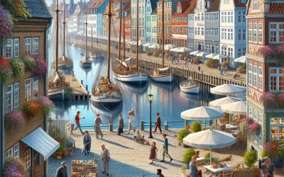
Denmark
Denmark (Kongeriget Danmark (Kingdom of Denmark)) Capital: Copenhagen Population (Estimated July 2012): 5,543,453 Area: 43,098 km2 or 16,640 mi2 Currency: Danish krone (DKK; plural kroner) Official Language: Danish Political Information: Constitutional Monarchy with a Democratic Parliamentary Representative. Official Religion: Evangelical Lutheran (approximately 95% of the population are Evangelical Lutheran, 3% are other Christian, 2% are Muslim) Highest Point: Yding Skovhøj at 172m or 564ft GDP Official Exchange Rate (OER is more precise at gauging a countries economic power) (Estimated 2011): $330.5 billion (US$) or (GBP) GDP (OER) Per Capita (per member of the population estimated 2011): (US$) or (GBP) GDP Purchasing Power Parity (PPP is good for gauging living conditions and use of resources but not as accurate as OER. This data has been calculated based on the sum value of all goods and services produced in the country valued at prices prevailing in the United States) (Estimated 2011): $206.8 billion (US$) or (GBP) GDP (PPP) Per Capita (per member of the population estimated 2011): $40,200 (US$) or (GBP) Time Zone (GMT/UTC): +1:00 Wildlife: Counties/Provinces/States: metropolitan Denmark – 5 regions (regioner, singular – region); Hovedstaden, Midtjylland, Nordjylland, Sjaelland, Syddanmark Leaders: Queen Margrethe II with Prime Minister Helle Thorning-Schmidt. Sources: CIA World Fact Book, Encyclopaedia Britannica. Denmark Denmark, located in Northern Europe, is a small but vibrant country known for its rich history, stunning landscapes, and high quality of life. It is often referred to as a Scandinavian jewel due to its picturesque cities, charming countryside, and friendly locals. Denmark is a popular destination for tourists from around the world, attracting visitors with its unique blend of history, culture, and natural beauty. Geography and Climate of Denmark: Land...
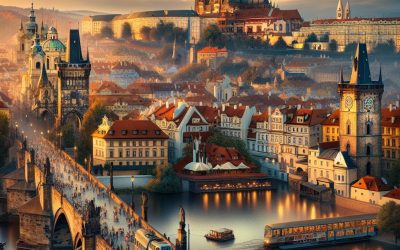
Czech Republic
Czech Republic (Česká republika) Capital: Prague Population (Estimated July 2012): 10,177,300 Area: 78,865 km2 or 30,450 mi2 Currency: Koruna (Kč) Official Language: Czech Political Information: Parliamentary Republic Official Religion: No Official Religion (approximately 26.8% of the population are Roman Catholic, 2.1% are Protestant, 3.3% have other religious beliefs, 8.8% have unspecified religious beliefs and 59% are unaffiliated) Highest Mountain: Sněžka at 1,602m or 5,256ft GDP Official Exchange Rate (OER is more precise at gauging a country’s economic power) (Estimated 2011): $220.3 billion (US$) or (GBP) GDP (OER) Per Capita (per member of the population estimated 2011): (US$) or (GBP) GDP Purchasing Power Parity (PPP is good for gauging living conditions and use of resources but is not as accurate as OER. This data has been calculated based on the sum value of all goods and services produced in the country valued at prices prevailing in the United States) (Estimated 2011): $272.2 billion (US$) or (GBP) GDP (PPP) Per Capita (per member of the population estimated 2011): $25,900 (US$) or (GBP) Time Zone (GMT/UTC): +1:00 Wildlife: Counties/Provinces/States: 13 regions (kraje, singular – kraj) and 1 capital city* (hlavni mesto); Jihocesky (South Bohemia), Jihomoravsky (South Moravia), Karlovarsky, Kralovehradecky, Liberecky, Moravskoslezsky (Moravia-Silesia), Olomoucky, Pardubicky, Plzensky (Pilsen), Praha (Prague)*, Stredocesky (Central Bohemia), Ustecky, Vysocina, Zlinsky Leaders: Vàclav Klaus as President with Petr Nečas as Prime Minister. Sources: CIA World Fact Book, Encyclopaedia Britannica. Czech Republic The Czech Republic, located in the heart of Europe, is a country that offers a rich history, stunning architecture, and a vibrant culture. Nestled between Germany, Austria, Slovakia, and Poland, the Czech Republic is known for its picturesque landscapes, charming towns, and bustling cities. The country’s capital, Prague,...
Terrain and Topography of Czech Republic: mountains, valleys, and plains.
The Czech Republic, located in Central Europe, is a country known for its rich history, stunning architecture, and vibrant culture. However, beyond the cities and towns lies a hidden treasure trove of natural wonders that are often overlooked by tourists. The country’s terrain and topography are diverse and offer a wide range of landscapes, from majestic mountains to picturesque valleys and vast plains. These natural wonders not only provide breathtaking views but also play a crucial role in the country’s tourism industry. Summary Czech Republic’s terrain and topography is diverse and awe-inspiring The majestic mountains, valleys, and plains offer a journey through nature’s beauty The Bohemian Massif is the backbone of Czech Republic’s terrain The Krkonoše Mountains are a paradise for hikers and skiers The Elbe Sandstone Mountains offer a spectacular landscape of rock formations and gorges The Majestic Mountains of Czech Republic: Awe-Inspiring Natural Wonders The Czech Republic is home to several mountain ranges that are truly awe-inspiring. The most famous of these is the Krkonoše Mountains, which are located along the border with Poland. These mountains are the highest in the country and offer stunning views of snow-capped peaks, deep valleys, and crystal-clear lakes. The Krkonoše Mountains are not only a popular destination for hikers and nature lovers but also for skiers during the winter months. Another notable mountain range in the Czech Republic is the Jeseníky Mountains, located in the northeastern part of the country. These mountains are known for their rugged beauty and offer a variety of outdoor activities such as hiking, mountain biking, and skiing. The Jeseníky Mountains are also home to several natural...
Climate Zones Of Czech Republic: Different climate regions Of Czech Republic
The Czech Republic is a landlocked country located in Central Europe. It is known for its diverse climate zones, which range from continental to oceanic, mountain, Mediterranean, subtropical, humid continental, and even polar. Understanding these climate zones is crucial for various reasons, including agriculture, tourism, and environmental conservation. In this article, we will explore each climate zone in detail, discussing their characteristics, distribution in the Czech Republic, and the flora and fauna that thrive in each zone. Summary Czech Republic has a diverse climate with eight different climate zones. The Continental Climate Zone is the most common and covers most of the country. The Oceanic Climate Zone is found in the western part of the country and is characterized by mild temperatures and high precipitation. The Mountain Climate Zone is found in the highest parts of the country and is characterized by low temperatures and high precipitation. The Mediterranean Climate Zone is the rarest and is found only in a small area in the southeast of the country. Continental Climate Zone The continental climate zone is characterized by hot summers and cold winters. It is typically found in the interior regions of the Czech Republic, away from the moderating influence of large bodies of water. The temperature range in this zone can be quite extreme, with temperatures reaching as high as 30°C (86°F) in summer and dropping to -20°C (-4°F) or lower in winter. Regions such as Moravia and parts of Bohemia fall within the continental climate zone. The flora in this zone includes deciduous trees such as oak, beech, and birch. Coniferous forests are also common, with pine...

Political Boundaries of Czech Republic: Provinces, Districts, or Historical Boundaries.
Political boundaries refer to the lines that separate different political entities, such as countries, provinces, and districts. These boundaries play a crucial role in governance and development, as they define the jurisdiction and authority of governments, determine the allocation of resources, and shape the identity and culture of a nation. In the case of Czech Republic, understanding its political boundaries is essential for comprehending its governance system and historical context. Summary Czech Republic is a landlocked country in Central Europe with a population of over 10 million people. The country is divided into 14 provinces, each with its own unique culture, history, and geography. There are 76 districts in Czech Republic, which play a significant role in local governance and administration. The country’s political boundaries have evolved over time, shaped by historical events and political decisions. Political boundaries have a significant impact on Czech Republic’s economy, society, and governance, and managing them presents both challenges and opportunities for the country’s development. Understanding the Provinces of Czech Republic Czech Republic is divided into 14 provinces, also known as regions. Each province has its own unique historical and cultural significance. For example, Prague is not only the capital city but also a province in itself. It is known for its rich history, stunning architecture, and vibrant cultural scene. Other provinces like South Bohemia are famous for their picturesque landscapes and historical towns such as Český Krumlov. Each province has its own distinct identity and contributes to the overall diversity of Czech Republic. The provinces are not only administrative divisions but also serve as centers for economic activities, tourism, and cultural heritage....