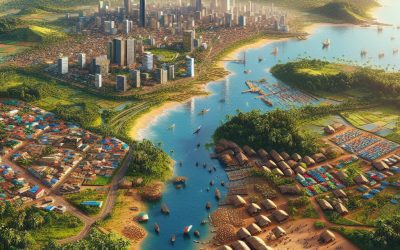
Explore the World Through Geography, Natural Resources & Daily History
Clear, reliable and engaging guides that help you understand our planet — from UK geography education to global natural resources and On This Day history events.
Explore, discover, and learn about the wonders of our world! At Earth Site, we’re passionate about bringing geography, history, and science to life for curious minds of all ages. Whether you’re delving into historical events, uncovering the mysteries of the natural world, or seeking interactive resources, you’re in the right place.
Here, you can uncover the stories behind historical events, explore the natural wonders of our planet, and gain valuable insights into how the Earth’s systems shape our daily lives. From the towering peaks of mountain ranges to the far-reaching impacts of human innovation, we aim to make every topic both engaging and informative.
Start your journey of discovery with us today, and let’s make learning an adventure!
What We Cover
Earth Site brings together engaging and accessible educational content designed to help you understand the world, its history, and its natural systems.
🌍 Geography Education (UK & Worldwide)
We publish clear, easy-to-understand geography resources for students, teachers and curious learners. Our guides support geography education in the UK and cover physical geography, climate, ecosystems, population, and global development.
⛏️ Natural Resources & Environmental Geography
Explore detailed country profiles covering natural resources, mining, energy, geology and global environmental challenges. We show how nations manage minerals, water, land and ecosystems, and why these resources matter.
📅 On This Day in History
Every day has a story. Our On This Day history series features major events, anniversaries, traditions, and cultural milestones from around the world — with timelines, context, and fun facts.
TIMELINE

Political Boundaries of Côte d’lvoire: Provinces, Districts, or Historical Boundaries.
Political boundaries refer to the lines that separate one political entity from another. These boundaries are crucial in defining the territorial limits of a country and determining its governance structure. In the case of Côte d’Ivoire, understanding its political boundaries is of utmost importance due to the country’s complex history and diverse population. Côte d’Ivoire, also known as Ivory Coast, is a West African country that shares borders with Liberia, Guinea, Mali, Burkina Faso, and Ghana. It has a coastline along the Gulf of Guinea. The country’s political boundaries have evolved over time, influenced by both pre-colonial and colonial factors. Understanding these boundaries is essential for comprehending the country’s governance structure and its impact on society. Summary Côte d’Ivoire has political boundaries that have evolved over time, with historical and administrative significance. The provinces of Côte d’Ivoire are important administrative divisions that help to govern the country. The local government system in Côte d’Ivoire is organized into districts, which play a key role in governance. Political boundaries have a significant impact on Côte d’Ivoire’s economy and society, and their maintenance is a challenge. Understanding the historical and current political boundaries of Côte d’Ivoire is important for effective governance and development. Historical Boundaries of Côte d’Ivoire: A Brief Overview Before the arrival of European colonial powers, Côte d’Ivoire was home to various ethnic groups with their own territories and boundaries. These pre-colonial boundaries were often fluid and subject to change as different groups migrated or expanded their territories. However, they played a significant role in defining the cultural and linguistic diversity of the region. During the colonial era, Côte d’Ivoire...

Climate Zones Of Côte d’lvoire: Different climate regions Of Côte d’lvoire
Côte d’lvoire, also known as Ivory Coast, is a country located in West Africa. It is bordered by Liberia, Guinea, Mali, Burkina Faso, and Ghana. The country has a diverse geography, with coastal plains, mountains, and plateaus. The climate in Côte d’lvoire varies across different regions, and it is important to understand these climate zones in order to better understand the country’s people and economy. Summary Côte d’lvoire has a diverse range of climate zones, including equatorial, monsoon, savannah, semi-arid, humid subtropical, coastal, and mountain regions. The equatorial region is characterized by high temperatures and rainfall throughout the year, while the monsoon region experiences a wet season and a dry season. The savannah region has a distinct wet and dry season, with temperatures varying throughout the year. The semi-arid region experiences low rainfall and high temperatures, with a dry season lasting up to 9 months. The coastal region has a humid and hot climate, with high rainfall and temperatures throughout the year. Climate change is having a significant impact on Côte d’lvoire’s climate zones, with rising temperatures and changing rainfall patterns affecting agriculture and water resources. Despite the challenges posed by climate change, the diversity of climate regions in Côte d’lvoire offers opportunities for adaptation and resilience. Understanding the unique characteristics of each climate zone is essential for effective climate change adaptation and mitigation strategies in Côte d’lvoire. Overall, Côte d’lvoire’s climate zones highlight the importance of considering local climate conditions in climate change planning and policy. Tropical Equatorial Climate Region of Côte d’lvoire The tropical equatorial climate region of Côte d’lvoire is characterized by high temperatures and heavy...

History of Côte d’lvoire
Côte d’Ivoire, also known as Ivory Coast, is a country located in West Africa. It has a rich and complex history that has shaped its present-day society and politics. Understanding the country’s past is crucial for its future development and progress. This article will provide a comprehensive overview of Côte d’Ivoire’s history, from its pre-colonial era to the present day, highlighting key events and developments that have shaped the nation. Summary Côte d’lvoire has a rich pre-colonial history, with various ethnic groups and kingdoms existing before European arrival. The French colonized the Ivory Coast in the late 19th century, exploiting its resources and establishing a system of forced labor. Félix Houphouët-Boigny became the first president of independent Côte d’lvoire, focusing on economic development and modernization. Political instability and ethnic tensions led to a civil war in the early 2000s, with Laurent Gbagbo as a key figure. The post-conflict era has seen progress in rebuilding and reconciliation, but challenges remain for Côte d’lvoire’s future development. Pre-colonial Era: The Origins of Côte d’Ivoire Côte d’Ivoire has a diverse geographical and cultural landscape. The region is characterized by dense forests, savannahs, and coastal areas. It was home to various ethnic groups, each with their own distinct cultures and traditions. Kingdoms and empires, such as the Kong Empire and the Gyaaman Kingdom, existed in the region before the arrival of Europeans. The transatlantic slave trade had a significant impact on the region. Many African slaves were captured and transported from Côte d’Ivoire to the Americas, leading to a loss of population and disruption of local societies. This period of history had lasting effects...

Terrain and Topography of Côte d’lvoire: mountains, valleys, and plains.
Côte d’Ivoire, also known as Ivory Coast, is a country located in West Africa. It is bordered by Liberia and Guinea to the west, Mali and Burkina Faso to the north, Ghana to the east, and the Atlantic Ocean to the south. With an area of approximately 322,463 square kilometers, it is one of the larger countries in the region. Understanding the terrain and topography of Côte d’Ivoire is crucial for various reasons, including agriculture, infrastructure development, and resource management. Summary Côte d’Ivoire has a diverse terrain and topography, including mountain ranges, valleys, and plains. The mountain ranges of Côte d’Ivoire are home to unique flora and fauna, and provide important water resources. The valleys of Côte d’Ivoire are characterized by their fertile soils and are important for agriculture. The plains of Côte d’Ivoire are significant for their large-scale agriculture and infrastructure development. The terrain and topography of Côte d’Ivoire have a significant impact on the country’s climate, agriculture, biodiversity, and human settlements. The Mountain Ranges of Côte d’Ivoire Côte d’Ivoire is home to three main mountain ranges: the Nimba Range, the Man Range, and the Toura Range. The Nimba Range is located in the western part of the country and extends into Guinea and Liberia. It is known for its rich biodiversity and is a UNESCO World Heritage Site. The Man Range is situated in the western part of Côte d’Ivoire and is characterized by its steep slopes and dense vegetation. The Toura Range, located in the central part of the country, is known for its granite peaks and scenic beauty. These mountain ranges play a significant role...

Natural Resources of Côte d’lvoire: Where Natural Resources are located In Côte d’lvoire
Côte d’lvoire, also known as Ivory Coast, is a country located in West Africa. It is bordered by Liberia and Guinea to the west, Mali and Burkina Faso to the north, Ghana to the east, and the Atlantic Ocean to the south. The country has a diverse range of natural resources, including minerals, agricultural resources, forests, water resources, oil and gas, coastal resources, wildlife and biodiversity, and renewable energy sources. Summary Côte d’lvoire has a diverse range of natural resources, including minerals, agriculture, forests, water, oil and gas, coastal areas, wildlife, and renewable energy. The country is rich in mineral resources, including gold, diamonds, iron ore, and bauxite, which contribute significantly to the economy. Agriculture is the backbone of the country’s economy, with cocoa being the main export crop, followed by coffee, palm oil, and rubber. Forests cover about 10 million hectares of land in Côte d’lvoire, providing timber, non-timber forest products, and ecosystem services. Water resources are abundant in the country, with several rivers and lakes, but there are challenges in managing and distributing water to meet the needs of the population. Mineral Resources in Côte d’lvoire Côte d’lvoire is rich in mineral resources, which play a significant role in the country’s economy. The major minerals found in the country include gold, diamonds, and iron ore. Gold mining is one of the main economic activities in Côte d’lvoire, with several large-scale gold mines operating in the country. The country is also known for its diamond deposits, particularly in the western part of the country. Iron ore deposits are found in the northern part of Côte d’lvoire. The mining...

Cultural or Historical Sites of Côte d’lvoire: Important Cultural Landmarks or Historical Sites in Côte d’lvoire
Côte d’lvoire, also known as Ivory Coast, is a country located in West Africa. It is known for its rich cultural heritage and diverse natural landscapes. The country is home to a vibrant mix of ethnic groups, each with their own unique traditions and customs. The cultural significance of Côte d’lvoire lies in its ability to preserve and showcase this diversity, making it a truly fascinating destination for travellers. The cultural heritage of Côte d’lvoire is deeply rooted in its history and traditions. The country has a long and complex history, with influences from various empires and colonial powers. This has resulted in a unique blend of cultures, languages, and religions. The people of Côte d’lvoire take great pride in their heritage and are eager to share it with visitors. Summary Côte d’lvoire is a culturally significant country with a rich history and diverse attractions. The Grand Mosque of Yamoussoukro is a stunning example of Islamic architecture and an important religious site. The Basilica of Our Lady of Peace is the largest Christian church in the world and a must-see for visitors. The Taï National Park is a UNESCO World Heritage Site and home to a variety of unique wildlife. The Ivory Coast National Museum is a treasure trove of Ivorian art and history, offering a fascinating glimpse into the country’s past. The Grand Mosque of Yamoussoukro: A Symbol of Islamic Architecture The Grand Mosque of Yamoussoukro is one of the most iconic landmarks in Côte d’lvoire. It is a symbol of Islamic architecture and a testament to the country’s religious diversity. The mosque was built in the 1980s...

Population Density of Côte d’lvoire
Côte d’lvoire, also known as Ivory Coast, is a country located in West Africa. It has a population of approximately 26 million people, making it one of the most populous countries in the region. Understanding the population density of Côte d’lvoire is crucial for policymakers and researchers as it provides valuable insights into the distribution of people across the country. This information can help in planning and implementing various development initiatives, such as infrastructure development, healthcare services, and education facilities. Summary Côte d’lvoire has a high population density of 83 people per square kilometer. Population density in Côte d’lvoire has been influenced by historical events such as colonialism and civil war. Factors such as climate, natural resources, and infrastructure have contributed to regional variations in population density across Côte d’lvoire. Urbanization has led to a significant increase in population density in Côte d’lvoire’s cities. Rural-urban migration has also contributed to population density in Côte d’lvoire, with many people moving to cities in search of better economic opportunities. Historical Overview of Population Density in Côte d’lvoire Over the years, Côte d’lvoire has experienced significant population growth. In the 1960s, the population was around 3 million, and by 2021, it had increased to 26 million. This rapid growth can be attributed to several factors. One of the main factors is improved healthcare services and a decline in mortality rates. The introduction of vaccinations and better access to healthcare facilities has led to a decrease in infant mortality rates and an increase in life expectancy. Another factor that has influenced population growth in Côte d’lvoire is high fertility rates. In the past,...
Cote d’Ivoire – Ivory Coast
Cote d’Ivoire – Ivory Coast (République de Côte d’Ivoire (Republic of Côte d’Ivoire [Ivory Coast])) Capital: Yamoussoukro Population (Estimated July 2012): 21,952,093 Area: 320,803 km2 or 123,863 mi2 Currency: CFA franc (CFAF) Official Language: French Political Information: Presidential Republic Official Religion: No Official Religion (approximately 38.6% of the population are Muslim, 32.8% are Christian, 11.9% have indigenous beliefs and 16.7% have no religious beliefs) Highest Mountain: Monts Nimba at 1,752m or 5,748ft GDP Official Exchange Rate (OER is more precise at gauging a countries economic power) (Estimated 2011): $23.8 billion (US$) or (GBP) GDP (OER) Per Capita (per member of the population estimated 2011): (US$) or (GBP) GDP Purchasing Power Parity (PPP is good for gauging living conditions and use of resources but not as accurate as OER. This data has been calculated based on the sum value of all goods and services produced in the country valued at prices prevailing in the United States) (Estimated 2011): $35.6 billion (US$) or (GBP) GDP (PPP) Per Capita (per member of the population estimated 2011): $1,600 (US$) or (GBP) Time Zone (GMT/UTC): GMT Wildlife: Counties/Provinces/States: regions; Agneby, Bafing, Bas-Sassandra, Denguele, Dix-Huit Montagnes, Fromager, Haut-Sassandra, Lacs, Lagunes, Marahoue, Moyen-Cavally, Moyen-Comoe, N’zi-Comoe, Savanes, Sud-Bandama, Sud-Comoe, Vallee du Bandama, Worodougou, Zanzan Leaders: President Alassane Ouattara with Guillaume Soro as Prime minister. Additional: Gained Independence from France on the 7th of August 1960 Sources: CIA World Fact Book, Encyclopaedia Britannica. Côte d’lvoire Côte d’lvoire, also known as Ivory Coast, is a country located in West Africa. It is known for its rich diversity and vibrant culture. With a population of over 25 million people, Côte d’Ivoire is home to more than 60...

Climate Zones Of Costa Rica: Different climate regions Of Costa Rica
Introduction to Costa Rica’s Climate Zones Costa Rica, located in Central America, is known for its stunning natural beauty and diverse ecosystems. From lush rainforests to pristine beaches, this small country offers a wide range of climates and landscapes. Understanding the different climate zones in Costa Rica is essential for both travelers and residents, as it can greatly impact the activities and experiences available in each region. Costa Rica’s geography plays a significant role in its climate variations. The country is divided into several distinct regions, each with its own unique climate characteristics. These climate zones are determined by factors such as altitude, proximity to the coast, and prevailing winds. By understanding these climate zones, visitors can plan their trips accordingly and make the most of their time in Costa Rica. The Tropical Wet Climate Zone The tropical wet climate zone is characterized by high temperatures and abundant rainfall throughout the year. This climate zone is found in the lowland areas along the Caribbean coast and parts of the Pacific coast. The average annual rainfall in these regions can exceed 100 inches, making them some of the wettest areas in Costa Rica. In the tropical wet climate zone, temperatures remain relatively constant throughout the year, with average highs ranging from 80 to 90 degrees Fahrenheit. Humidity levels are also high, creating a hot and sticky environment. The wettest months are typically September and October, while the driest months are February and March. The best time to visit the tropical wet climate zone is during the dry season, which runs from December to April. During this time, rainfall is minimal,...

Climate Zones Of Costa Rica: Different climate regions Of Costa Rica
Costa Rica, located in Central America, is known for its stunning natural beauty and diverse ecosystems. The country is home to a wide range of climate zones, each with its own unique characteristics and biodiversity. From tropical rainforests to cloud forests, highlands to coastal areas, Costa Rica offers a variety of climates for visitors to explore. Understanding these different climate zones is crucial for planning a trip to Costa Rica and experiencing the country’s rich natural wonders. Summary Costa Rica has diverse climate zones, each with unique characteristics and biodiversity. The tropical rainforest climate zone is hot and humid, with high rainfall and dense vegetation. The humid subtropical climate zone has a wet season and a dry season, with cooler temperatures than the rainforest zone. The tropical dry forest climate zone has a distinct dry season, with deciduous trees and shrubs adapted to the lack of rainfall. The cloud forest climate zone is cooler and wetter than the rainforest zone, with a unique ecosystem of mosses, ferns, and epiphytes. The highland climate zone has cooler temperatures and distinct seasons, with agriculture and ecotourism as major industries. The coastal climate zone has a tropical savanna climate, with hot temperatures and a dry season, and is home to many marine species. Climate zones affect Costa Rica’s biodiversity, with each zone supporting different plant and animal species. The best times to visit each climate zone vary, with some zones having peak tourist seasons during the dry season and others during the wet season. Climate change is impacting Costa Rica’s climate zones, with changes in rainfall patterns and temperatures affecting ecosystems and biodiversity....

Political Boundaries of Costa Rica: Provinces, Districts, or Historical Boundaries.
Costa Rica, a small country located in Central America, is known for its stunning natural beauty, rich biodiversity, and commitment to environmental conservation. However, behind this idyllic image lies a complex political system with various levels of governance and administrative divisions. In this article, we will explore the political boundaries of Costa Rica and their significance in shaping the country’s governance, society, culture, and economic development. Summary Costa Rica is divided into seven provinces, each with its own capital city and local government. Districts are the smallest administrative units in Costa Rica, with each province containing several districts. Historical boundaries of Costa Rica have evolved over time, with changes in political power and territorial disputes. Political boundaries have played a significant role in shaping Costa Rican culture and society, with regional identities and traditions emerging. The management of political boundaries in Costa Rica presents both challenges and opportunities for economic development and governance. Overview of Costa Rica’s Political Boundaries Political boundaries refer to the lines that demarcate different administrative divisions within a country. In Costa Rica, these boundaries are divided into three main levels: provinces, districts, and cantons. Provinces are the highest level of political division and there are seven provinces in Costa Rica: San Jose, Alajuela, Cartago, Heredia, Guanacaste, Puntarenas, and Limon. Each province is further divided into districts, which are then subdivided into cantons. A map of Costa Rica’s political boundaries provides a visual representation of these divisions. It shows the borders between provinces and the location of districts within each province. This map is an essential tool for understanding the administrative structure of Costa Rica and...

Terrain and Topography of Costa Rica: mountains, valleys, and plains.
Costa Rica, located in Central America, is a country known for its stunning natural beauty and diverse topography. From majestic mountain ranges to lush valleys and vast plains, the country’s landscape is shaped by its unique geography. The topography of Costa Rica plays a crucial role in determining the country’s climate, as well as providing opportunities for adventure, agriculture, and wildlife conservation. Summary Costa Rica’s topography is incredibly diverse, featuring majestic mountain ranges, lush valleys, and vast plains. The mountain ranges of Costa Rica play a crucial role in the country’s biodiversity, providing a habitat for a wide range of plant and animal species. The valleys of Costa Rica are known for their fertile soil and are often used for agriculture, making them a vital part of the country’s economy. The plains of Costa Rica are a unique landscape, home to a variety of wildlife and offering opportunities for adventure tourism. Costa Rica’s topography has a significant impact on the country’s climate, with different regions experiencing different weather patterns. The Majestic Mountain Ranges of Costa Rica Costa Rica is home to several mountain ranges that stretch across the country. The most prominent of these is the Cordillera Central, which runs through the center of the country and includes several active volcanoes. The highest peak in Costa Rica, Cerro Chirripó, is located in this range and offers breathtaking views from its summit. The Talamanca Range, located in the southern part of the country, is another notable mountain range in Costa Rica. This range is home to the country’s second-highest peak, Mount Kamuk, as well as the famous Chirripó National Park....