Explore the World Through Geography, Natural Resources & Daily History
Clear, reliable and engaging guides that help you understand our planet — from UK geography education to global natural resources and On This Day history events.
Explore, discover, and learn about the wonders of our world! At Earth Site, we’re passionate about bringing geography, history, and science to life for curious minds of all ages. Whether you’re delving into historical events, uncovering the mysteries of the natural world, or seeking interactive resources, you’re in the right place.
Here, you can uncover the stories behind historical events, explore the natural wonders of our planet, and gain valuable insights into how the Earth’s systems shape our daily lives. From the towering peaks of mountain ranges to the far-reaching impacts of human innovation, we aim to make every topic both engaging and informative.
Start your journey of discovery with us today, and let’s make learning an adventure!
What We Cover
Earth Site brings together engaging and accessible educational content designed to help you understand the world, its history, and its natural systems.
🌍 Geography Education (UK & Worldwide)
We publish clear, easy-to-understand geography resources for students, teachers and curious learners. Our guides support geography education in the UK and cover physical geography, climate, ecosystems, population, and global development.
⛏️ Natural Resources & Environmental Geography
Explore detailed country profiles covering natural resources, mining, energy, geology and global environmental challenges. We show how nations manage minerals, water, land and ecosystems, and why these resources matter.
📅 On This Day in History
Every day has a story. Our On This Day history series features major events, anniversaries, traditions, and cultural milestones from around the world — with timelines, context, and fun facts.
TIMELINE
Azerbaijan: Ecology and Natural Resources
Azerbaijan and Its Rich Natural Resources: Ecology and Natural Resources Azerbaijan is a land of striking contrasts, where the majestic Caucasus mountains meet the Caspian Sea, and vast reserves of energy resources coexist with efforts toward environmental protection. This article explores the natural resources of Azerbaijan, its ecological policies, and the vital role played by the Ministry of Ecology and Natural Resources in managing the nation’s wealth. Whether you’re curious about oil and gas, water resources, or the government’s green agenda, this is a comprehensive guide worth your time. 📚 Article Outline What Makes Azerbaijan Unique in Terms of Natural Resources? How Does the Ministry of Ecology and Natural Resources Operate? What Role Does the Caspian Sea Play in Azerbaijan’s Resource Economy? Oil and Gas: The Backbone of Production in Azerbaijan What Are the Key Mineral Resources in the Country? How Significant Are Azerbaijan’s Water Resources? What Environmental Protection Efforts Exist in the Republic of Azerbaijan? How Are Natural Resources Affecting Azerbaijan’s GDP? What is the Historical Role of the Absheron Peninsula? What Are the Challenges and Future Directions for Sustainability? 1. What Makes Azerbaijan Unique in Terms of Natural Resources? Azerbaijan is renowned for its wealth of natural resources, especially oil and gas, which have shaped its geopolitical and economic relevance. Strategically located between Eastern Europe and Western Asia, the Republic of Azerbaijan sits atop rich deposits that have attracted foreign interest since the beginning of the 20th century. The natural resources of Azerbaijan include not just hydrocarbons but also iron ore, pyrite, chalcopyrite, and zeolite raw materials found in regions such as Gobustan, Shamkir, and Ordubad. These...
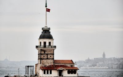
Discovering Azerbaijan’s Cultural & Historical Landmarks
Azerbaijan is a country with a rich cultural heritage that spans centuries. From its ancient cities to its rural areas, Azerbaijan is filled with historical landmarks, unique traditions, and a diverse cuisine. Preserving this cultural heritage is of utmost importance, as it allows future generations to connect with their roots and understand the history and traditions of their ancestors. Summary Azerbaijan boasts a rich cultural heritage with influences from various civilizations. The ancient city of Baku is a must-visit destination for history and architecture enthusiasts. Rural areas in Azerbaijan offer hidden gems waiting to be discovered by adventurous travellers. Azerbaijani carpet weaving is a cultural treasure that has been passed down through generations. Azerbaijan’s diverse cuisine, from traditional dishes to modern fusion, is a reflection of its cultural diversity. The ancient city of Baku: exploring its history and architecture Baku, the capital city of Azerbaijan, is a treasure trove of history and architecture. The city has a long and storied past, dating back to ancient times. It has been influenced by various civilizations, including the Persians, Arabs, Mongols, and Russians. This rich history is reflected in the city’s architecture, which showcases a blend of different styles. Famous landmarks in Baku include the Maiden Tower, a UNESCO World Heritage Site that dates back to the 12th century. The tower is an iconic symbol of Baku and offers panoramic views of the city. Another notable landmark is the Palace of the Shirvanshahs, a medieval palace complex that was once the seat of power for the Shirvanshah dynasty. Baku’s architecture also includes modern marvels such as the Flame Towers, a trio of...
Political Boundaries of Austria: Provinces, Districts, or Historical Boundaries.
Austria is a landlocked country located in Central Europe. It is bordered by eight countries: Germany, Czech Republic, Slovakia, Hungary, Slovenia, Italy, Switzerland, and Liechtenstein. Austria has a parliamentary representative democracy, with a federal structure. The country is divided into nine provinces, each with its own government and legislature. Understanding Austria’s political boundaries is crucial for understanding the country’s political system and its history. Summary Austria is divided into nine provinces, each with its own distinct identity and culture. Districts play an important role in Austria’s political system, serving as administrative units within the provinces. Austria’s historical boundaries have shifted over time, with the country experiencing periods of expansion and contraction. The country’s borders have had a significant impact on its history, shaping its political, economic, and cultural development. Regional identity is an important aspect of Austria’s political landscape, with many citizens identifying strongly with their province or district. Understanding the Provinces of Austria Austria is divided into nine provinces, also known as Bundesländer. These provinces are Burgenland, Carinthia, Lower Austria, Upper Austria, Salzburg, Styria, Tyrol, Vorarlberg, and Vienna. Each province has its own distinct culture, geography, and politics. For example, Carinthia is known for its beautiful lakes and mountains, while Vienna is the capital city and the cultural and political center of the country. The provinces also have their own governments and legislatures, which have the power to make decisions on matters that are within their jurisdiction. This decentralization of power allows for a more balanced distribution of resources and decision-making across the country. It also ensures that the needs and interests of each province are taken into...
Climate Zones of Austria: Different Climate Regions Of Austria
Austria, located in Central Europe, is known for its stunning landscapes, rich history, and diverse climate zones. The country is landlocked and bordered by eight countries, including Germany, Czech Republic, and Italy. Due to its geographical location and topography, Austria experiences a wide range of climates, from alpine to subarctic and Mediterranean. Understanding Austria’s climate zones is crucial for various reasons, including agriculture, tourism, and urban planning. Summary Austria has a diverse range of climate zones due to its location in central Europe. The Alpine climate region is characterized by cold winters and mild summers, with high precipitation levels. The Continental climate region experiences hot summers and cold winters, with moderate precipitation. The Pannonian climate region has hot summers and cold winters, with low precipitation levels. The Subarctic climate region is characterized by long, cold winters and short, cool summers. The Mediterranean climate region has mild winters and hot summers, with low precipitation levels. The Temperate Oceanic climate region experiences mild temperatures and high precipitation levels throughout the year. Climate variations across Austria’s provinces are influenced by altitude, topography, and proximity to bodies of water. Climate zones have a significant impact on Austria’s agriculture, with certain crops and livestock thriving in specific regions. Climate change is affecting Austria’s climate zones, with rising temperatures and changing precipitation patterns leading to potential impacts on agriculture and natural ecosystems. Alpine Climate Region in Austria The Alpine climate region is one of the most prominent in Austria due to the presence of the Austrian Alps. This region is characterized by high altitudes, cold winters, and mild summers. The Alpine climate is influenced by...
Terrain and Topography of Austria: mountains, valleys, and plains.
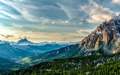
Austria, located in Central Europe, is a landlocked country known for its stunning landscapes and diverse terrain. The country is bordered by eight countries, including Germany, Czech Republic, Slovakia, Hungary, Slovenia, Italy, Switzerland, and Liechtenstein. Austria’s geography is characterized by its mountainous regions, rolling hills, plateaus, valleys, and lakes. The terrain and topography of Austria have played a significant role in shaping the country’s culture and economy. The diverse terrain of Austria has influenced various aspects of its culture. The mountainous regions have given rise to a strong tradition of mountaineering and winter sports. Austrians take great pride in their alpine heritage and have a deep connection to the mountains. The mountains also provide a backdrop for traditional folk music and dance, which are an integral part of Austrian culture. In terms of the economy, Austria’s terrain has contributed to the development of industries such as tourism, agriculture, forestry, and transportation. The majestic Austrian Alps attract millions of tourists each year who come to enjoy activities such as skiing, hiking, and mountaineering. The fertile valleys and plateaus are ideal for agriculture and forestry, while the rivers and lakes provide transportation routes for goods and people. Summary Austria’s terrain and topography is diverse and varied. The Austrian Alps are awe-inspiring and majestic. The Eastern Alps offer a unique landscape. The Danube Valley is a fertile and scenic region. Austria’s topography includes rolling hills, plateaus, and vast terrains. The Majestic Austrian Alps: Awe-Inspiring Mountains The Austrian Alps are one of the most awe-inspiring mountain ranges in Europe. They stretch across the western and central parts of Austria and are part of...
Population Density of Austria
Population density refers to the number of individuals living in a specific area, usually measured per square kilometer. It is an important indicator of how crowded or sparse a region is and provides insights into the distribution of people within a country. Studying population density in Austria is crucial for understanding the social, economic, and environmental dynamics of the country. Austria, a landlocked country in Central Europe, has a rich history and diverse geography. It is known for its stunning landscapes, vibrant cities, and high standard of living. Understanding the population density in Austria helps policymakers, urban planners, and researchers make informed decisions about resource allocation, infrastructure development, and environmental conservation. Summary Austria has a population density of 106 people per square kilometer. The population density of Austria has been steadily increasing since the 19th century. Vienna has the highest population density in Austria, while the western regions have the lowest. Factors affecting Austria’s population density include urbanization, migration, and economic opportunities. Future projections suggest that Austria’s population density will continue to increase, particularly in urban areas. Historical Overview of Austria’s Population Density Over the years, Austria’s population density has undergone significant changes. In the early 19th century, the country experienced a period of rapid population growth due to improvements in healthcare and living conditions. This led to an increase in population density, particularly in urban areas. However, during the 20th century, Austria faced several challenges that influenced its population density. The two World Wars and subsequent political changes resulted in large-scale migration and displacement. Many people fled the country or were forced to leave their homes, leading to...
Cultural or Historical Sites of Austria: Important Cultural Landmarks or Historical Sites In Austria
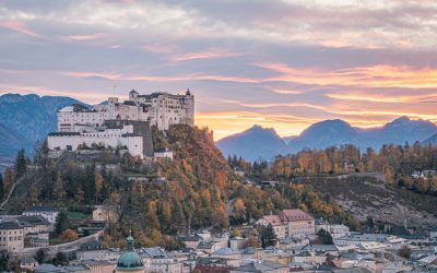
Austria is a country with a rich history and cultural heritage that spans centuries. From its imperial past to its contributions to the world of music and art, Austria has left an indelible mark on the world. One of the best ways to understand Austria’s past is by visiting its historical landmarks. These landmarks not only showcase the country’s architectural beauty but also provide a glimpse into its fascinating history. Whether it’s exploring the grandeur of the Imperial Palace or marveling at the Gothic masterpiece of St. Stephen’s Cathedral, each landmark tells a unique story that is worth discovering. Summary The Imperial Palace offers a glimpse into Austria’s royal past with its opulent interiors and extensive art collections. History buffs must visit the Hofburg Complex, which served as the seat of power for the Habsburg dynasty for centuries. The Salzburg Cathedral is a stunning example of Austria’s rich religious heritage, with its ornate Baroque architecture and impressive artwork. The Schönbrunn Palace is a must-see for lovers of Baroque architecture, with its grand gardens and lavish interiors. The Melk Abbey is a majestic Benedictine monastery that showcases Austria’s rich cultural and religious history. The Imperial Palace: A Window into Austria’s Royal Past The Imperial Palace, also known as the Hofburg Palace, is one of Vienna’s most iconic landmarks. It served as the residence of the Habsburg dynasty, one of Europe’s most powerful royal families, for over six centuries. The palace complex is vast and offers visitors a chance to explore various museums and attractions that provide insights into Austria’s royal past. One of the highlights of a visit to the...
Natural Resources of Austria: Where Natural Resources are Located in Austria
Natural Resources of Austria: Where Natural Resources are Located in Austria Austria is more than just a scenic alpine wonder—it’s a nation with a wealth of natural resources and a deeply rooted tradition of environmental protection and sustainable development. From its mineral-rich mountains to its fertile farmland and dense forests, the natural resources of Austria play a key role in shaping the country’s economy, identity, and international standing. This article explores how Austria’s unique geography, diverse raw materials, and careful environmental policies work together to power its GDP, support its people, and safeguard future generations. Austria, located in Central Europe, is known for its stunning landscapes and rich natural resources. The country is bordered by Germany, Czech Republic, Slovakia, Hungary, Slovenia, Italy, Switzerland, and Liechtenstein. Its diverse geography includes the Alps in the west, the Danube River in the north, and the Pannonian Plain in the east. These geographical features contribute to Austria’s abundance of natural resources, including forests, minerals, water, agricultural land, geothermal energy, wildlife, and oil and gas reserves. Article Outline 1. What Makes Austria’s Geography Unique for Natural Resource Utilisation? 2. Which Mineral Resources Are Found in Austria? 3. How Important Is the Mining Industry to the Austrian Economy? 4. What Role Does Agriculture and Forestry Play in Austria’s Resource Sector? 5. How Does Austria Use Its Arable Land Effectively? 6. What Are the Major Agricultural Products of Austria? 7. How Do Forestry and Timber Contribute to Austria’s GDP? 8. How Has Austria Adapted to Structural Changes in the Global Economy? 9. What Is the Role of Environmental Protection in Resource Management? 10. How Do...

Political Boundaries of Armenia: Provinces, Districts, or Historical Boundaries.
Armenia, a landlocked country located in the South Caucasus region of Eurasia, is known for its rich history and cultural heritage. Understanding the political boundaries of Armenia is crucial for effective governance and administration. Political boundaries define the territorial limits of a country and play a significant role in shaping its governance structure, policies, and relationships with other nations. Summary Armenia is a landlocked country in the South Caucasus region, bordered by Georgia, Azerbaijan, Iran, and Turkey. Armenia is divided into 11 provinces, each with its own governor and administrative center. Districts are the smallest administrative units in Armenia, responsible for local governance and public services. Armenia’s historical boundaries have fluctuated over time due to wars, treaties, and political changes. Soviet rule had a significant impact on Armenia’s political boundaries, including the creation of new administrative divisions and the incorporation of Nagorno-Karabakh. Understanding Armenia’s Administrative Divisions: Provinces Armenia is divided into provinces, also known as marzes, which serve as administrative divisions within the country. There are a total of 11 provinces in Armenia, each with its own unique characteristics and significance. These provinces play a crucial role in governance by decentralizing power and allowing for local administration and decision-making. For example, the province of Shirak is located in the northwestern part of Armenia and is known for its agricultural production. It is home to several important cities, including Gyumri, the second-largest city in Armenia. The province of Syunik, on the other hand, is located in the southern part of the country and is known for its natural beauty and historical sites. It is also strategically important due to its...

Climate Zones of Armenia: Different climate regions Of Armenia
Armenia, a landlocked country in the South Caucasus region of Eurasia, is known for its diverse geography and climate. Situated between Europe and Asia, Armenia is surrounded by mountains and has a varied topography, ranging from highlands to lowlands. This geographical diversity contributes to the presence of multiple climate zones in the country. Understanding these climate zones is crucial for various industries, including agriculture, as it helps determine the suitability of different crops and farming practices in different regions. Summary Armenia has a diverse range of climate zones, including continental, highland, Mediterranean, subtropical, humid continental, semi-arid, and desert. The continental climate of Armenia is characterized by hot summers and cold winters, with significant temperature fluctuations throughout the year. The highland climate of Armenia is characterized by cool summers and cold winters, with high levels of precipitation. The Mediterranean climate of Armenia is characterized by mild, wet winters and hot, dry summers. The subtropical climate of Armenia is characterized by hot, humid summers and mild winters with high levels of precipitation. The impact of these climate zones on agriculture in Armenia is significant, with certain crops thriving in specific regions and others struggling to grow. Microclimates also play a role in agriculture, with variations in temperature, precipitation, and soil affecting crop growth. Continental Climate of Armenia The continental climate is the most dominant climate zone in Armenia. It is characterized by hot summers and cold winters, with significant temperature variations throughout the year. The average temperature in summer ranges from 25°C to 35°C (77°F to 95°F), while in winter, it can drop as low as -15°C to -20°C (5°F to...

Terrain and Topography of Armenia: mountains, valleys, and plains.
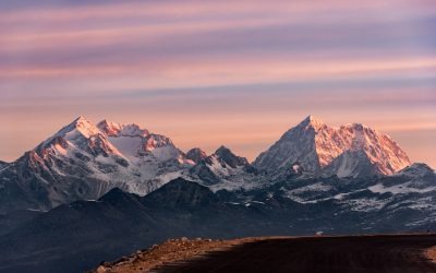
Armenia, a landlocked country in the South Caucasus region of Eurasia, is known for its diverse and stunning terrain. Nestled between the Black Sea to the north and the Caspian Sea to the east, Armenia is characterized by its mountainous landscape, deep valleys, and vast plains. The country’s topography has played a significant role in shaping its history, culture, and economy. The terrain of Armenia is dominated by the Armenian Highlands, a vast plateau that stretches across the country. The highlands are surrounded by several mountain ranges, including the Lesser Caucasus to the south and the Geghama Mountains to the east. These mountains not only provide breathtaking scenery but also serve as important cultural and religious symbols for the Armenian people. Summary Armenia’s terrain is diverse and includes mountains, valleys, and plains. The mountains of Armenia are mighty and offer opportunities for hiking and skiing. The valleys of Armenia are lush and fertile, making them ideal for agriculture. The vast plains of Armenia are home to many important cities and towns. The terrain of Armenia has a significant impact on its climate, agriculture, and history. The Mighty Mountains of Armenia Armenia is often referred to as the “Land of Mountains,” and for good reason. The country is home to several majestic mountain ranges that offer a wide range of outdoor activities and breathtaking views. The highest peak in Armenia is Mount Aragats, standing at an impressive 4,090 meters (13,419 feet) above sea level. Mountains hold great significance in Armenian culture and religion. They are often associated with strength, endurance, and spirituality. Many ancient Armenian monasteries and churches are perched...

Cultural or Historical Sites of Armenia: Important Cultural Landmarks or Historical Sites In Armenia
Armenia, a small country located in the South Caucasus region of Eurasia, is known for its rich history and cultural heritage. With a history dating back thousands of years, Armenia has been home to various civilizations and empires, each leaving their mark on the land. From ancient cities to medieval monasteries, Armenia is a treasure trove of archaeological sites and monuments that offer a glimpse into its fascinating past. Exploring these ancient sites is not only a way to learn about Armenia’s history but also to appreciate its cultural heritage and the resilience of its people. Summary Ani offers a glimpse into Armenia’s medieval past with its well-preserved ruins. Geghard Monastery showcases the country’s unique blend of spirituality and architecture. The Temple of Garni is a must-visit for those interested in Armenia’s pagan history. The Armenian Genocide Memorial is a somber reminder of the country’s tragic past. The Matenadaran is a treasure trove of Armenian literature and intellectual heritage. The Ancient City of Ani: A Window into Armenia’s Medieval Past One of the most significant ancient sites in Armenia is the city of Ani. Located on the border with Turkey, Ani was once the capital of the Bagratid Kingdom of Armenia in the 10th and 11th centuries. Known as the “City of 1001 Churches,” Ani was a thriving center of trade and culture during its heyday. Today, it stands as a testament to Armenia’s medieval past. The architecture of Ani is a blend of Armenian, Byzantine, and Islamic influences. The city is home to numerous churches, palaces, and fortifications, each showcasing intricate stone carvings and architectural details. Some of...