Explore the World Through Geography, Natural Resources & Daily History
Clear, reliable and engaging guides that help you understand our planet — from UK geography education to global natural resources and On This Day history events.
Explore, discover, and learn about the wonders of our world! At Earth Site, we’re passionate about bringing geography, history, and science to life for curious minds of all ages. Whether you’re delving into historical events, uncovering the mysteries of the natural world, or seeking interactive resources, you’re in the right place.
Here, you can uncover the stories behind historical events, explore the natural wonders of our planet, and gain valuable insights into how the Earth’s systems shape our daily lives. From the towering peaks of mountain ranges to the far-reaching impacts of human innovation, we aim to make every topic both engaging and informative.
Start your journey of discovery with us today, and let’s make learning an adventure!
What We Cover
Earth Site brings together engaging and accessible educational content designed to help you understand the world, its history, and its natural systems.
🌍 Geography Education (UK & Worldwide)
We publish clear, easy-to-understand geography resources for students, teachers and curious learners. Our guides support geography education in the UK and cover physical geography, climate, ecosystems, population, and global development.
⛏️ Natural Resources & Environmental Geography
Explore detailed country profiles covering natural resources, mining, energy, geology and global environmental challenges. We show how nations manage minerals, water, land and ecosystems, and why these resources matter.
📅 On This Day in History
Every day has a story. Our On This Day history series features major events, anniversaries, traditions, and cultural milestones from around the world — with timelines, context, and fun facts.
TIMELINE

Proterozoic Eon (2.5 billion – 541 million years ago) – Oxygen builds up; first multicellular life.
The Proterozoic Eon, spanning from approximately 2.5 billion to 541 million years ago, represents a significant chapter in Earth’s geological and biological history. This eon is the second of the four major divisions of geological time, following the Archean Eon and preceding the Phanerozoic Eon. The Proterozoic is characterised by profound changes in the planet’s atmosphere, lithosphere, and biosphere, setting the stage for the complex life forms that would emerge in subsequent eras. During this time, Earth underwent a series of transformative events that shaped its physical and biological landscape, including the gradual accumulation of oxygen in the atmosphere and the emergence of multicellular organisms. The Proterozoic Eon is often divided into three distinct eras: the Paleoproterozoic, Mesoproterozoic, and Neoproterozoic. Each of these eras is marked by unique geological and biological developments. The Paleoproterozoic era saw the formation of stable continental landmasses and the first evidence of photosynthetic life, while the Mesoproterozoic era was characterised by the diversification of microbial life and significant geological activity. The Neoproterozoic era is particularly notable for its climatic fluctuations and the emergence of multicellular organisms, which would eventually lead to the Cambrian Explosion. Understanding the Proterozoic Eon is crucial for comprehending the evolutionary trajectory of life on Earth and the environmental conditions that facilitated this evolution. Summary The Proterozoic Eon, lasting from 2.5 billion to 541 million years ago, was a crucial period in Earth’s history. Oxygen levels in the Proterozoic Eon fluctuated significantly, leading to major environmental changes and the emergence of complex life forms. Multicellular life began to emerge during the Proterozoic Eon, marking a significant milestone in the history of...

Archean Eon (4.0 – 2.5 billion years ago) – First life appears; early continents form.
The Archean Eon, spanning from approximately 4.0 to 2.5 billion years ago, represents a pivotal chapter in Earth’s geological history. This era is characterised by the formation of the planet’s first stable crust and the emergence of life, albeit in its most primitive forms. The term “Archean” is derived from the Greek word “archaios,” meaning ancient, which aptly reflects the eon’s significance in the context of Earth’s development. The Archean Eon is often viewed as a time of transformation, where the planet transitioned from a molten state to one that could support life, setting the stage for the complex biosphere that would follow. During this eon, the Earth was a vastly different place compared to today. The atmosphere was likely rich in methane and ammonia, with little to no free oxygen present. The oceans were also in their infancy, filled with dissolved minerals and organic compounds. The geological processes that shaped the planet were dominated by volcanic activity and tectonic movements, leading to the formation of the first continental landmasses. Understanding the Archean Eon is crucial for comprehending not only the origins of life but also the early environmental conditions that influenced biological evolution. Summary The Archean Eon, lasting from 4 to 2.5 billion years ago, was a crucial period in Earth’s history. Geological and environmental conditions during the Archean Eon were characterized by high temperatures, volcanic activity, and the absence of free oxygen in the atmosphere. The emergence of the first life forms, such as single-celled organisms, marked a significant milestone in the Archean Eon. Early continents began to form during the Archean Eon, shaping the Earth’s landmasses...

Hadean Eon (4.6 – 4.0 billion years ago) – Earth forms; Theia impact creates the Moon.
Hadean Eon (4.6 – 4.0 billion years ago) – Earth forms; Theia impact creates the Moon. The Hadean Eon, a term derived from the Greek word “Hades,” refers to the earliest period in Earth’s history, spanning from approximately 4.6 billion years ago to about 4 billion years ago. This eon is characterised by extreme conditions that were inhospitable to life as we know it today. The Hadean is not merely a time frame; it represents a formative phase in the development of our planet, during which the fundamental processes that would shape Earth and its environment took place. The name itself evokes images of a hellish landscape, reflecting the tumultuous and chaotic nature of this era. During the Hadean Eon, the Earth was still in its infancy, forming from the primordial accretion of dust and gas surrounding the young Sun. This period was marked by intense geological activity, including frequent volcanic eruptions and the constant bombardment of meteoroids. The surface of the planet was molten, and temperatures were exceedingly high, creating a dynamic environment that would eventually lead to the formation of a stable crust. Understanding the Hadean Eon is crucial for comprehending the subsequent development of Earth and the conditions that would eventually allow for the emergence of life. Summary The Hadean Eon is the earliest eon in Earth’s history, lasting from 4.6 to 4 billion years ago. Earth formed from the accretion of dust and gas in the solar nebula, leading to the differentiation of its layers. The Theia Impact refers to the collision between Earth and a Mars-sized body, leading to the formation of the Moon....

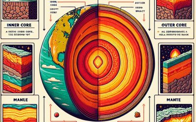
Precambrian Eon (4.6 billion – 541 million years ago)
The Precambrian Eon represents a vast stretch of time in Earth’s history, encompassing approximately 88% of the planet’s geological timeline. This eon is often overshadowed by the subsequent Phanerozoic Eon, which is characterised by abundant fossil records and the emergence of complex life forms. The Precambrian, however, is crucial for understanding the origins of Earth and the early development of life. It is divided into three major geological timeframes: the Hadean, Archean, and Proterozoic eons. Each of these periods is marked by significant geological and biological developments that laid the groundwork for the evolution of life as we know it today. The term “Precambrian” itself is somewhat of a misnomer, as it encompasses a diverse array of geological and biological phenomena that occurred long before the Cambrian period. The lack of extensive fossil records from this time has led to a certain degree of mystery surrounding the Precambrian, making it a subject of intense study and debate among geologists and paleontologists. Understanding this eon is essential for piecing together the complex history of our planet, as it provides insights into the conditions that fostered the emergence of life and the subsequent evolution of ecosystems. Summary The Precambrian Eon is the longest and least understood span of Earth’s history, lasting from about 4.6 billion years ago to 541 million years ago....

Valley Forge (1777–1778)
The winter encampment of the Continental Army at Valley Forge during the winter of 1777-1778 stands as a pivotal moment in the American Revolutionary War. Situated approximately 18 miles northwest of Philadelphia, this site became synonymous with the trials and tribulations faced by the fledgling army. General George Washington, recognising the strategic importance of the location, chose Valley Forge not only for its defensible position but also for its proximity to British forces in Philadelphia. The encampment lasted from December 19, 1777, to June 19, 1778, and during this time, the army endured one of the most challenging winters in American history. The decision to establish a winter camp at Valley Forge was fraught with difficulties. The Continental Army had suffered significant losses in previous battles, and morale was at an all-time low. The soldiers were not only facing the enemy on the battlefield but also the harsh realities of winter. The encampment consisted of around 12,000 troops, many of whom were ill-equipped and underfed. The makeshift huts constructed from logs and mud provided minimal shelter against the biting cold, and the lack of adequate clothing left many soldiers vulnerable to frostbite and illness. Despite these challenges, the encampment would ultimately serve as a crucible for transformation, shaping the Continental Army into a more disciplined and effective fighting force. Summary The Continental Army’s Winter Encampment at Valley Forge was a pivotal moment in the American Revolutionary War, lasting from December 1777 to June 1778. Harsh conditions and challenges, including extreme cold, lack of proper clothing and shelter, and food shortages, tested the soldiers’ endurance and resilience. Leadership and training...
Geological Epochs (Earth’s History)
Geological epochs represent significant intervals in Earth’s history, characterised by distinct geological and biological developments. These epochs are part of a broader framework known as the geological time scale, which divides Earth’s 4.5 billion-year history into eons, eras, periods, epochs, and ages. This classification system allows scientists to communicate about the timing and relationships of events in Earth’s history with precision. Each epoch is marked by notable changes in the planet’s geology, climate, and life forms, reflecting the dynamic processes that have shaped the Earth over millennia. Understanding geological epochs is crucial for comprehending the evolution of life and the planet itself. Each epoch encapsulates a unique chapter in the story of Earth, revealing how environmental conditions influenced the development of ecosystems and the organisms that inhabit them. By studying these epochs, geologists and paleontologists can piece together the complex puzzle of Earth’s past, providing insights into how life has adapted to changing conditions and how these changes have been recorded in the rock layers that make up the Earth’s crust. Summary Geological epochs are distinct periods of time in Earth’s history, each with its own unique characteristics and developments. The Precambrian Eon is the earliest and longest geological time period, spanning from the formation of the Earth to the emergence of complex life forms. The Paleozoic Era is known as the Age of Ancient Life, marked by the emergence and diversification of marine life, as well as the first land plants and animals. The Mesozoic Era, also known as the Age of Dinosaurs, saw the dominance of dinosaurs and the emergence of birds and flowering plants. The Cenozoic...

Boston Siege (1775–1776)
The years leading up to the Siege of Boston were marked by escalating tensions between the American colonists and British authorities. The imposition of various taxes, such as the Stamp Act of 1765 and the Townshend Acts of 1767, ignited widespread resentment among the colonists, who felt increasingly alienated from a government that imposed regulations without their consent. The rallying cry of “no taxation without representation” became a potent slogan, encapsulating the growing discontent. The Boston Massacre in March 1770, where British soldiers killed five colonists during a confrontation, further inflamed these tensions, serving as a catalyst for revolutionary sentiment. This incident was not merely a tragic event; it was a turning point that galvanised public opinion against British rule and united disparate colonial factions. As the situation deteriorated, Boston emerged as a focal point of resistance. The formation of groups such as the Sons of Liberty, who actively opposed British policies through protests and boycotts, illustrated the increasing willingness of colonists to confront British authority. The Tea Act of 1773, which granted the British East India Company a monopoly on tea sales in the colonies, led to the infamous Boston Tea Party, where colonists disguised as Mohawk Indians dumped an entire shipment of tea into Boston Harbour. This act of defiance prompted a harsh response from the British government, including the Coercive Acts of 1774, which sought to punish Massachusetts and restore order. These measures only served to deepen the divide, as they were perceived as an infringement on colonial autonomy and rights. By the time the first shots were fired at Lexington and Concord in April 1775,...

The American Revolution
The American Revolution was not a spontaneous event; rather, it was the culmination of a series of complex factors that had been brewing for decades. One of the primary causes was the growing sense of American identity among the colonists. By the mid-18th century, the thirteen colonies had developed distinct social, economic, and political characteristics that set them apart from Britain. The colonists began to see themselves not merely as subjects of the British Crown but as individuals with their own rights and aspirations. This burgeoning sense of identity was further fuelled by the Enlightenment ideals of liberty, equality, and self-governance, which permeated colonial society and encouraged a questioning of traditional authority. Economic factors also played a significant role in igniting revolutionary sentiments. The colonies were increasingly frustrated by British mercantilist policies that restricted their trade and economic growth. The Navigation Acts, which mandated that certain goods produced in the colonies could only be shipped to England or English colonies, stifled economic opportunities for many colonists. Additionally, the imposition of taxes without representation, such as the Stamp Act and the Townshend Acts, incited widespread resentment. Colonists felt that they were being unfairly burdened to support a government that did not represent their interests, leading to a growing demand for autonomy and self-determination. Summary...

Victory at Yorktown (1781)
Victory at Yorktown (1781) The Battle of Yorktown fought in 1781, marked a pivotal moment in the American Revolutionary War, a conflict that had been raging since 1775. The war was rooted in the growing discontent of the American colonies towards British rule, particularly regarding taxation without representation and the lack of autonomy. Tensions escalated following events such as the Boston Tea Party and the Intolerable Acts, leading to the formation of the Continental Congress and the eventual declaration of independence in 1776. By 1781, the war had reached a critical juncture, with both sides weary from years of conflict. The British, under King George III, sought to maintain control over the colonies, while the American patriots, led by figures such as George Washington, were determined to secure their freedom. Yorktown, located in Virginia, became a strategic focal point due to its geographical significance. The British had established a stronghold there, believing it to be a secure base for their operations in the southern colonies. General Cornwallis, commanding British forces, aimed to consolidate his troops and supply lines while simultaneously quelling the growing resistance from American forces. However, unbeknownst to Cornwallis, the American and French forces were plotting a decisive counter-offensive that would ultimately lead to his downfall. The stage was set for a confrontation that would not only determine the fate of Cornwallis’s army but also significantly influence the outcome of the war itself. Summary The Battle of Yorktown was a decisive battle in the American Revolutionary War, taking place from September 28 to October 19, 1781. The Siege of Yorktown was a joint operation by American and...

Stellar & Galactic Epoch (1 billion years – present) – Modern galaxies, stars, and planetary systems develop.
The cosmos is a vast expanse of time and space, a theatre of celestial phenomena that has captivated human imagination for millennia. The Stellar and Galactic Epoch represents a significant chapter in the history of the universe, encompassing the formation and evolution of stars and galaxies from the primordial chaos following the Big Bang to the intricate structures we observe today. This epoch is marked by a series of transformative events that have shaped the very fabric of the universe, leading to the rich tapestry of celestial bodies that populate our night sky. At the heart of this epoch lies the interplay between gravity, nuclear fusion, and cosmic evolution. The universe, initially a hot and dense state, began to cool, allowing for the formation of hydrogen and helium atoms. Over time, these primordial elements coalesced under the influence of gravity, giving rise to the first stars and galaxies. This process not only illuminated the universe but also set the stage for the complex interactions that would lead to the formation of planets and, ultimately, life itself. Understanding this epoch is crucial for comprehending our place in the cosmos and the processes that govern stellar and galactic evolution. Summary The Stellar & Galactic Epoch marks the beginning of the universe’s formation and the birth of galaxies. Modern galaxies formed through the merging of smaller galaxies and the accretion of gas and dust. Stars evolve through various stages, from protostars to main sequence stars, and eventually to white dwarfs, neutron stars, or black holes. Planetary systems develop from the remnants of star formation, with planets forming in protoplanetary disks around young...

Crossing the Delaware (1776)
The crossing of the Delaware River on the night of December 25-26, 1776, stands as a pivotal moment in the American Revolutionary War. This audacious manoeuvre was not merely a tactical operation; it was a bold statement of resolve and determination by General George Washington and his Continental Army. At this juncture, the American forces were beleaguered, having suffered a series of defeats that had severely undermined morale and support for the revolutionary cause. The British had captured New York City and were advancing into New Jersey, leaving Washington’s troops in a precarious position. The crossing represented a desperate gamble to regain momentum and inspire hope among the colonists. The strategic significance of this operation cannot be overstated. By crossing the icy waters of the Delaware, Washington aimed to surprise the Hessian forces stationed in Trenton, New Jersey. The element of surprise was crucial; the Hessians, mercenaries hired by the British, were not expecting an attack during the harsh winter conditions. Washington’s decision to launch this offensive was rooted in a broader strategy to shift the tide of the war. A successful engagement at Trenton would not only bolster the morale of his troops but also reinvigorate support for the revolutionary cause among the populace. It was a calculated risk that could potentially alter the course of the conflict. Summary The strategic importance of crossing the Delaware was crucial for the American forces to surprise and defeat the Hessian troops during the Revolutionary War. The planning and preparation for the crossing involved meticulous coordination and secrecy to ensure the success of the mission. The challenges faced during the crossing,...

Reionization Epoch (150 million – 1 billion years) – The first stars and galaxies form.
The Reionization Epoch represents a pivotal chapter in the history of the universe, occurring approximately between 400 million and 1 billion years after the Big Bang. This period is characterised by the transition of the universe from a neutral state, dominated by hydrogen and helium, to an ionised state, where the majority of hydrogen atoms lost their electrons. This transformation was crucial for the evolution of cosmic structures and the subsequent formation of galaxies, stars, and other celestial bodies. The Reionization Epoch is not merely a phase in cosmic history; it is a fundamental process that shaped the observable universe as we know it today. During this epoch, the universe underwent significant changes as the first luminous objects began to form. These early stars and galaxies emitted vast amounts of ultraviolet radiation, which played a critical role in ionising the surrounding hydrogen gas. The study of this epoch provides insights into the conditions of the early universe, the formation of cosmic structures, and the processes that led to the emergence of galaxies. Understanding reionization is essential for astronomers and cosmologists as it helps to bridge the gap between the dark ages of the universe and the bright, structured cosmos we observe in the present day. Summary The Reionization Epoch marks a significant period in the history of the universe when the first stars and galaxies formed. The formation of the first stars played a crucial role in the reionization of the universe, as their intense radiation ionized the surrounding hydrogen gas. The emergence of the first galaxies further contributed to the reionization process, as their combined radiation continued to...