Explore the World Through Geography, Natural Resources & Daily History
Clear, reliable and engaging guides that help you understand our planet — from UK geography education to global natural resources and On This Day history events.
Explore, discover, and learn about the wonders of our world! At Earth Site, we’re passionate about bringing geography, history, and science to life for curious minds of all ages. Whether you’re delving into historical events, uncovering the mysteries of the natural world, or seeking interactive resources, you’re in the right place.
Here, you can uncover the stories behind historical events, explore the natural wonders of our planet, and gain valuable insights into how the Earth’s systems shape our daily lives. From the towering peaks of mountain ranges to the far-reaching impacts of human innovation, we aim to make every topic both engaging and informative.
Start your journey of discovery with us today, and let’s make learning an adventure!
What We Cover
Earth Site brings together engaging and accessible educational content designed to help you understand the world, its history, and its natural systems.
🌍 Geography Education (UK & Worldwide)
We publish clear, easy-to-understand geography resources for students, teachers and curious learners. Our guides support geography education in the UK and cover physical geography, climate, ecosystems, population, and global development.
⛏️ Natural Resources & Environmental Geography
Explore detailed country profiles covering natural resources, mining, energy, geology and global environmental challenges. We show how nations manage minerals, water, land and ecosystems, and why these resources matter.
📅 On This Day in History
Every day has a story. Our On This Day history series features major events, anniversaries, traditions, and cultural milestones from around the world — with timelines, context, and fun facts.
TIMELINE

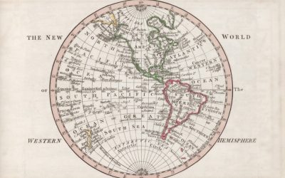
Map Projections: How Maps Distort the Earth
Map projections are essential tools in cartography, serving as the bridge between the three-dimensional reality of our planet and the two-dimensional representations we use for navigation, education, and exploration. At its core, a map projection is a systematic method of transforming the curved surface of the Earth onto a flat plane. This transformation is not merely a technical challenge; it embodies a complex interplay of mathematics, geography, and artistic interpretation. The Earth, being an oblate spheroid, presents unique challenges for cartographers who strive to depict its features accurately while maintaining usability for various applications. Understanding map projections requires an appreciation of the underlying principles that govern how we represent spatial relationships and geographical features. The significance of map projections extends beyond mere aesthetics; they influence how we perceive the world around us. Each projection offers a different perspective, highlighting certain areas while diminishing others. For instance, a projection that preserves area may distort shapes, while one that maintains shape may compromise area accuracy. This inherent trade-off is crucial for users to grasp, as it shapes their understanding of global geography. Furthermore, the choice of projection can reflect cultural and political biases, subtly influencing how regions are viewed and understood. Thus, delving into the realm of map projections is not just an academic exercise; it is an exploration of how we interpret and interact with our world. Summary Map projections are methods used to represent the 3D surface of the earth on a 2D map. There are various types of map projections, each with its own set of advantages and disadvantages. Distortions in map projections can occur in terms of...

Smart city planning for environmental sustainability
In an era marked by rapid urbanisation and the pressing challenges of climate change, the concept of smart city planning has emerged as a beacon of hope for sustainable urban development. Smart city planning refers to the integration of technology, data, and innovative practices to enhance the quality of life for residents while promoting environmental sustainability. This multifaceted approach seeks to address the myriad issues faced by modern cities, including traffic congestion, pollution, and inadequate public services. By leveraging advanced technologies such as the Internet of Things (IoT), big data analytics, and artificial intelligence, urban planners can create more efficient, responsive, and resilient urban environments that cater to the needs of their inhabitants. The significance of smart city planning extends beyond mere technological advancement; it embodies a holistic vision for urban living that prioritises sustainability and inclusivity. As cities continue to grow, the demand for resources intensifies, leading to increased pressure on infrastructure and natural ecosystems. Smart city initiatives aim to mitigate these pressures by fostering a collaborative approach among stakeholders, including government agencies, private enterprises, and local communities. This collaborative framework not only enhances decision-making processes but also ensures that the voices of diverse populations are heard in shaping the urban landscape. Ultimately, smart city planning represents a paradigm shift in how we conceive urban spaces, moving towards a future where technology and sustainability coexist harmoniously. Summary Smart city planning involves the use of technology and data to improve the quality of life for residents and enhance the efficiency of urban services. Environmental sustainability is crucial in urban planning to address issues such as pollution, resource depletion, and...

The Smallest Countries in the World: Geography and History
The world is a vast tapestry of nations, each with its own unique identity, culture, and history. Among these nations, a select few stand out not for their size or population, but rather for their diminutive stature. The smallest countries in the world, often overlooked in discussions about global influence and power, offer a fascinating glimpse into the complexities of nationhood. These microstates, which include the likes of Vatican City, Monaco, and Nauru, challenge conventional notions of what it means to be a country. Their limited geographical footprint belies their rich histories and vibrant cultures, making them intriguing subjects for exploration. Despite their small size, these countries often wield a surprising amount of influence on the global stage. They serve as important hubs for diplomacy, finance, and tourism, showcasing how even the tiniest nations can play significant roles in international affairs. The unique characteristics of these microstates—ranging from their governance structures to their economic models—provide valuable insights into the diverse ways in which societies can organise themselves. As we delve deeper into the geography, history, culture, and challenges faced by these small nations, we will uncover the remarkable stories that define them and highlight their contributions to the global community. Summary The smallest countries in the world are often overlooked but hold unique significance. Despite their small size, these countries boast diverse geography, from tropical islands to urban city-states. The history and culture of the smallest countries are rich and varied, influenced by their unique position in the world. Economically and politically, these countries may be small, but they often punch above their weight on the global stage. Challenges...

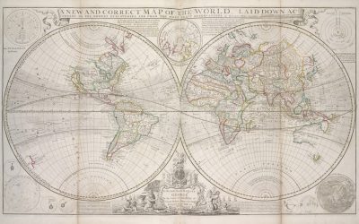
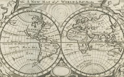
The Art and Science of Creating a World Map
The history of cartography is a fascinating journey that reflects humanity’s evolving understanding of the world. From the earliest days of human civilization, maps have served as essential tools for navigation, exploration, and territorial claims. The ancient Babylonians, for instance, created some of the earliest known maps on clay tablets, depicting their surroundings with a remarkable degree of accuracy for their time. These early representations were not merely practical; they were also imbued with cultural significance, often reflecting the beliefs and values of the societies that produced them. As civilisations advanced, so too did their mapping techniques. The Greeks made significant contributions to cartography, with figures like Ptolemy laying the groundwork for future mapmakers by introducing concepts such as latitude and longitude. His work, “Geographia,” compiled knowledge from various sources and established a framework that would influence cartographers for centuries. As the Middle Ages unfolded, the art of mapmaking experienced a transformation, particularly in Europe. Maps became more decorative and symbolic, often serving religious or political purposes rather than strictly geographical ones. The T-O maps of the medieval period, for example, depicted the world as a circle divided into three parts: Asia, Europe, and Africa, with Jerusalem at the centre. This representation was less about geographical accuracy and more about conveying a worldview shaped by faith and cultural narratives. The Age of Exploration in the 15th and 16th centuries marked a pivotal moment in cartography, as explorers like Columbus and Magellan ventured into uncharted territories. Their discoveries prompted a surge in map production, leading to more accurate depictions of the world. The advent of printing technology further revolutionised cartography,...

What Are Topographic Maps and How Are They Used?
Topographic maps are intricate representations of the Earth’s surface, capturing the three-dimensional features of terrain in a two-dimensional format. These maps are distinguished by their use of contour lines, which connect points of equal elevation, thereby illustrating the undulating nature of landscapes. Unlike standard road maps that primarily focus on transportation routes and urban areas, topographic maps provide a wealth of information about the physical characteristics of a region, including hills, valleys, rivers, and forests. This detailed portrayal allows users to visualise the topography of an area, making them invaluable tools for a variety of applications, from outdoor recreation to scientific research. The significance of topographic maps extends beyond mere aesthetics; they serve as essential resources for understanding geographical features and their implications on human activity. For instance, hikers and climbers rely on these maps to navigate challenging terrains, while environmental scientists utilise them to study ecosystems and landforms. The intricate details captured in topographic maps can reveal patterns in land use, hydrology, and even climate variations. As such, they are not only a reflection of the physical world but also a crucial element in the interplay between nature and human development. Summary Topographic maps are detailed representations of the Earth’s surface, showing the shape and elevation of the land. These maps are created using a combination of aerial photography, satellite imagery, and ground surveys to accurately depict the terrain. Understanding the symbols and legends on topographic maps is crucial for interpreting features such as contour lines, vegetation, water bodies, and man-made structures. Topographic maps are essential tools for geographers and cartographers, providing valuable information for land use planning,...
Understanding Latitude and Longitude
Latitude and longitude are fundamental concepts in the realm of geography, serving as the backbone of our understanding of the Earth’s surface. These two coordinates allow us to pinpoint any location on the globe with remarkable precision, facilitating navigation, mapping, and a myriad of other applications. The system of latitude and longitude is not merely a modern invention; it has evolved over centuries, drawing from the observations of ancient astronomers and navigators who sought to make sense of the vastness of the Earth. By establishing a grid that divides the planet into measurable sections, latitude and longitude provide a universal language for identifying locations, transcending linguistic and cultural barriers. The significance of latitude and longitude extends beyond mere navigation; they are integral to various fields such as meteorology, environmental science, and urban planning. For instance, understanding the geographical coordinates of a location can help in predicting weather patterns or assessing climate change impacts. Furthermore, in an increasingly globalised world, these coordinates play a crucial role in international relations, trade, and even military strategy. As we delve deeper into the intricacies of latitude and longitude, we will uncover their measurement, application in navigation, and their overarching importance in geography. Summary Latitude and longitude are geographical coordinates used to pinpoint a location on the Earth’s surface. Latitude measures the distance north or south of the equator, while longitude measures the distance east or west of the Prime Meridian. Latitude is measured in degrees, with the equator at 0° and the poles at 90°, while longitude is measured in degrees, with the Prime Meridian at 0° and the International Date Line at...
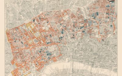
Types of Maps and Their Uses
Maps have long served as essential tools for navigation, exploration, and understanding the world around us. From ancient times, when early cartographers painstakingly sketched the contours of known lands, to the sophisticated digital maps we rely on today, the evolution of mapping has been a testament to humanity’s quest for knowledge and orientation. Maps are not merely representations of geographical spaces; they encapsulate cultural, historical, and political narratives, providing insights into how societies perceive their environment. The art and science of cartography have transformed significantly over the centuries, with advances in technology allowing for increasingly detailed and interactive representations of our planet. In contemporary society, maps are ubiquitous, appearing in various forms and serving multiple purposes. They can be found in textbooks, on smartphones, and even as decorative art pieces. The significance of maps extends beyond mere navigation; they are vital in fields such as urban planning, environmental science, and education. Understanding the different types of maps and their specific uses is crucial for anyone seeking to navigate the complexities of our world. This article will delve into various categories of maps, exploring their unique characteristics and applications, ultimately guiding readers in selecting the most appropriate map for their needs. Summary Maps are visual representations of the Earth’s surface, showing various features and information. Political maps display boundaries, cities, and countries, and are used for understanding political divisions and locations. Physical maps show natural features such as mountains, rivers, and deserts, and are used for understanding the physical landscape of an area. Topographic maps display elevation and terrain, and are used for hiking, camping, and other outdoor activities. Climate...

Sustainable transportation (cycling, public transit)
Sustainable transportation encompasses a range of practices and modes that aim to reduce environmental impact while promoting social equity and economic viability. One of the most significant benefits of sustainable transportation is its potential to mitigate climate change. By reducing reliance on fossil fuels, sustainable transport options such as cycling, walking, and public transit can significantly lower greenhouse gas emissions. This shift not only contributes to cleaner air and a healthier environment but also fosters a sense of community as people engage more with their surroundings. Furthermore, sustainable transportation can lead to reduced traffic congestion, which in turn decreases the time spent commuting and enhances overall quality of life. The integration of green transport solutions into urban planning can create more liveable cities, where residents enjoy improved access to amenities and recreational spaces. In addition to environmental benefits, sustainable transportation also promotes economic advantages. By investing in infrastructure for walking, cycling, and public transit, cities can stimulate local economies through job creation and increased foot traffic in commercial areas. Moreover, sustainable transport options often require less maintenance and operational costs compared to traditional car-centric systems. This economic efficiency can free up public funds for other essential services, such as education and healthcare. Furthermore, as more individuals adopt sustainable modes of transport, there is a potential for reduced healthcare costs associated with sedentary lifestyles and pollution-related illnesses. In essence, the benefits of sustainable transportation extend beyond mere environmental considerations; they encompass a holistic approach to improving urban living and fostering resilient communities. Summary Sustainable transportation reduces air pollution and greenhouse gas emissions, leading to improved public health and a cleaner...
How Geography Influences World Records
Altitude plays a pivotal role in shaping athletic performance, particularly in endurance sports. As athletes ascend to higher elevations, the air pressure decreases, leading to a reduction in the availability of oxygen. This phenomenon can significantly affect an athlete’s ability to perform at their peak. For instance, elite runners and cyclists often train at high altitudes to acclimatise their bodies to lower oxygen levels, which can enhance their performance when they return to sea level. The physiological adaptations that occur during this acclimatisation process include increased red blood cell production and improved oxygen transport efficiency. Consequently, athletes who effectively harness the benefits of altitude training can experience marked improvements in their endurance capabilities, allowing them to push the boundaries of their performance. However, the impact of altitude is not universally beneficial; it can also present formidable challenges. Athletes competing at high altitudes may experience symptoms of altitude sickness, which can include headaches, nausea, and fatigue. These symptoms can hinder performance and may even lead to disqualification in extreme cases. Moreover, the psychological aspect of competing in such conditions cannot be overlooked. The mental fortitude required to overcome the discomfort associated with high-altitude events is immense. Athletes must not only contend with the physical demands but also maintain focus and determination amidst the challenges posed by their environment. Thus, while altitude can serve as a double-edged sword, it remains a critical factor in the realm of athletic performance, influencing both training regimens and competitive outcomes. Summary Altitude can significantly impact athletic performance, with higher altitudes leading to decreased oxygen levels and reduced performance. Climate plays a crucial role in breaking...
The History of Cartography: From Ancient Maps to Google Earth
Cartography, the art and science of map-making, has been an integral part of human history, serving as a vital tool for navigation, exploration, and understanding our world. From the earliest depictions of land and sea to the sophisticated digital maps we rely on today, cartography has evolved dramatically over the centuries. It is not merely a technical discipline; it embodies a rich tapestry of cultural, political, and scientific narratives that reflect humanity’s quest for knowledge and connection. Maps have the power to shape perceptions, influence decisions, and even alter the course of history, making the study of cartography both fascinating and essential. The significance of cartography extends beyond its practical applications; it is a reflection of the societies that create them. Each map tells a story, revealing the priorities, beliefs, and limitations of its time. As we delve into the history of cartography, we uncover the interplay between geography and culture, as well as the technological advancements that have propelled this field forward. The journey through cartography’s past not only highlights the ingenuity of early map-makers but also sets the stage for understanding contemporary mapping practices and their implications for our future. Summary Cartography is the art and science of map-making, and it has evolved significantly over time. Ancient maps and pioneering cartographers laid the foundation for early cartography, shaping the way we view the world. The Age of Exploration and the Golden Age of Cartography saw a surge in map-making and exploration, leading to more accurate and detailed maps. Modern cartography and Geographic Information Systems (GIS) have revolutionised the way we collect, analyse, and present geographic data. The...
How to Read a Map: The Basics of Map Interpretation
The key, or legend, of a map serves as an essential guide, providing the necessary information to decode the symbols and colours that represent various features of the landscape. It is a crucial component that allows users to interpret the map accurately, transforming abstract symbols into tangible real-world elements. For instance, a blue line may signify a river, while a green area could indicate a forest or park. Without this vital tool, navigating through unfamiliar terrain would be akin to deciphering a foreign language without a dictionary. The key not only clarifies what each symbol represents but also often includes information about the scale of the map, which is indispensable for understanding distances and dimensions. Moreover, the key can vary significantly from one map to another, reflecting the specific focus and purpose of each cartographic representation. A topographical map may include intricate details such as elevation changes and land use, while a road map might prioritise transportation routes and urban areas. This diversity in mapping styles necessitates a thorough examination of the key before embarking on any journey. By familiarising oneself with the symbols and their meanings, one can enhance their navigational skills and ensure a more efficient exploration of the environment. Thus, understanding the key is not merely an academic exercise; it is a practical necessity for anyone seeking to traverse new landscapes with confidence and clarity. Summary Understanding the key is essential for interpreting symbols and colours on a map Using coordinates and grid references helps pinpoint specific locations on a map Orienting the map correctly ensures the right direction is always known Identifying landmarks and features...

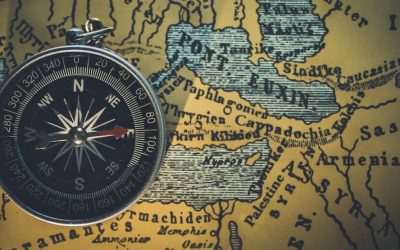
Cartography and Maps
The history of cartography is a fascinating chronicle that traces humanity’s quest to understand and represent the world around us. From the earliest cave drawings to the sophisticated digital maps of today, the evolution of map-making reflects not only advancements in technology but also shifts in cultural perspectives and scientific understanding. Ancient civilisations, such as the Babylonians and Greeks, laid the groundwork for cartographic practices, producing rudimentary maps that depicted their known world. The Greeks, particularly figures like Ptolemy, introduced concepts of latitude and longitude, which provided a framework for more accurate representations of geographical features. These early maps were often imbued with mythological elements, revealing how societies interpreted their surroundings through a blend of observation and imagination. As the centuries progressed, cartography underwent significant transformations, particularly during the Age of Exploration in the 15th and 16th centuries. This period marked a surge in maritime exploration, leading to the creation of more detailed and expansive maps that reflected newfound knowledge of distant lands. The advent of printing technology allowed for the mass production of maps, making them more accessible to the public and fostering a greater interest in geography. Notable cartographers such as Gerardus Mercator developed innovative projection techniques that enabled sailors to navigate more effectively across vast oceans. The interplay between exploration, science, and art during this era not only enriched cartographic practices but also shaped global perceptions of geography, influencing trade routes, colonisation efforts, and cultural exchanges. Summary Cartography has a rich history dating back to ancient times, with maps evolving from simple drawings to sophisticated digital representations. Maps play a crucial role in modern society, aiding...