Explore the World Through Geography, Natural Resources & Daily History
Clear, reliable and engaging guides that help you understand our planet — from UK geography education to global natural resources and On This Day history events.
Explore, discover, and learn about the wonders of our world! At Earth Site, we’re passionate about bringing geography, history, and science to life for curious minds of all ages. Whether you’re delving into historical events, uncovering the mysteries of the natural world, or seeking interactive resources, you’re in the right place.
Here, you can uncover the stories behind historical events, explore the natural wonders of our planet, and gain valuable insights into how the Earth’s systems shape our daily lives. From the towering peaks of mountain ranges to the far-reaching impacts of human innovation, we aim to make every topic both engaging and informative.
Start your journey of discovery with us today, and let’s make learning an adventure!
What We Cover
Earth Site brings together engaging and accessible educational content designed to help you understand the world, its history, and its natural systems.
🌍 Geography Education (UK & Worldwide)
We publish clear, easy-to-understand geography resources for students, teachers and curious learners. Our guides support geography education in the UK and cover physical geography, climate, ecosystems, population, and global development.
⛏️ Natural Resources & Environmental Geography
Explore detailed country profiles covering natural resources, mining, energy, geology and global environmental challenges. We show how nations manage minerals, water, land and ecosystems, and why these resources matter.
📅 On This Day in History
Every day has a story. Our On This Day history series features major events, anniversaries, traditions, and cultural milestones from around the world — with timelines, context, and fun facts.
TIMELINE

Highlighting the challenges of water scarcity in desert and semi-arid zones and explore innovative solutions for sustainable living.
Water scarcity is a critical issue in desert and semi-arid zones, where water availability is constrained due to low rainfall and high evaporation rates. These regions support diverse ecosystems and communities, all of which depend on water for survival. The limited water supply in these areas has widespread consequences, impacting not only local populations but also the delicate equilibrium of ecosystems. As water demand increases due to population growth and climate change, it is imperative to address water scarcity in these regions through sustainable management practices and innovative solutions. The effects of water scarcity in desert and semi-arid zones are multifaceted, influencing both human settlements and the natural environment. Communities in these regions often struggle to access clean and safe drinking water, resulting in health problems and diminished quality of life. Agriculture, a crucial source of livelihood for many in these areas, also suffers due to water scarcity, leading to food insecurity and economic difficulties. Ecosystems in desert and semi-arid zones are likewise under threat, as water scarcity can result in habitat degradation and loss of biodiversity. It is evident that addressing water scarcity in these regions is essential for the welfare of both people and the environment. Summary Water scarcity is a pressing issue in desert and semi-arid zones, impacting both communities and ecosystems. Traditional water management practices have been crucial in these regions, but innovative solutions are needed for sustainable water management. Technology plays a significant role in mitigating water scarcity, offering potential solutions for sustainable water management. Community engagement and education are essential for promoting sustainable living and addressing water scarcity in these regions. Addressing water...

Water Scarcity in Arid Climate Zones: Innovative Solutions
Water scarcity in arid climate zones has a significant impact on the environment, economy and well-being of communities. These regions, characterised by limited rainfall and high evaporation rates, face considerable challenges in meeting the water needs of their populations. The shortage of water resources affects agriculture, industry and domestic use, resulting in reduced crop yields, constrained economic growth and increased competition for water. Moreover, the lack of access to clean and safe drinking water can have serious health implications, leading to waterborne diseases and malnutrition. The depletion of groundwater reserves and degradation of ecosystems further exacerbate the impact of water scarcity, posing a threat to biodiversity and the sustainability of natural resources. The consequences of water scarcity in arid climate zones are extensive and require urgent attention to mitigate its effects. The lack of water impedes agricultural productivity, leading to food insecurity and poverty among rural communities. Industries reliant on water for production face operational challenges, affecting employment and economic growth. Furthermore, the scarcity of water resources can lead to conflicts over access to water, exacerbating social tensions and political instability. Addressing water scarcity in arid climate zones is crucial for sustainable development and the well-being of communities, necessitating innovative solutions and collaborative efforts to ensure access to clean and safe water for all. Summary Water scarcity in arid climate zones has a significant impact on communities, agriculture, and the environment, leading to increased competition for limited water resources. Innovative water conservation techniques such as drip irrigation, greywater recycling, and xeriscaping are crucial for managing water scarcity in arid climate zones. Desalination technology offers a promising solution for water...
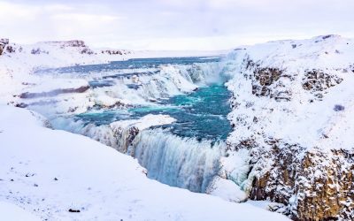
Glacial Retreat and Its Impact on Highland and Polar Zones
Glacial retreat refers to the process of glaciers shrinking and receding due to the effects of climate change. This phenomenon is a direct result of global warming, which has caused a rise in temperatures and subsequently led to the melting of ice in polar and highland regions. Glacial retreat is a significant indicator of climate change and has far-reaching implications for ecosystems, water resources, biodiversity, and human societies. As glaciers continue to melt at an alarming rate, it is crucial to understand the impact of this phenomenon on the environment and to develop strategies to mitigate its effects. Glacial retreat is a natural process that has occurred throughout Earth’s history, but the current rate of retreat is unprecedented. The Intergovernmental Panel on Climate Change (IPCC) has reported that glaciers are losing mass at an accelerating rate, with significant implications for sea level rise and water availability. The primary cause of glacial retreat is the increase in greenhouse gas emissions, which trap heat in the Earth’s atmosphere and lead to a rise in global temperatures. As a result, glaciers are melting at an alarming rate, leading to the loss of freshwater resources, changes in ecosystems, and increased risks of natural disasters such as glacial lake outburst floods. It is essential to understand the impact of glacial retreat on various ecosystems and to develop strategies to mitigate its effects. Summary Glacial retreat is the process of glaciers shrinking and melting due to rising temperatures, leading to significant environmental impacts. Highland ecosystems are experiencing changes in vegetation, water availability, and wildlife habitats due to glacial retreat, affecting biodiversity and ecosystem stability. Polar...

Exploring how different climate zones affect the potential for renewable energy sources like solar, wind, and hydropower.
Climate zones play a crucial role in determining the potential for renewable energy sources. These zones are defined by a combination of factors such as temperature, precipitation and wind patterns. Understanding the unique characteristics of each climate zone is essential for harnessing the full potential of renewable energy sources. Renewable energy, such as solar, wind and hydropower, offers a sustainable alternative to traditional fossil fuels and has the potential to mitigate the impacts of climate change. By tapping into the natural resources available in different climate zones, we can reduce our reliance on non-renewable energy sources and move towards a more sustainable future. Renewable energy sources are abundant in various climate zones around the world, offering a diverse range of opportunities for harnessing clean energy. Solar energy is particularly abundant in arid and tropical climate zones, whilst wind energy is more prevalent in coastal and high-altitude regions. Hydropower, on the other hand, is abundant in areas with high levels of precipitation and river systems. By understanding the unique characteristics of each climate zone, we can identify the most suitable renewable energy sources and technologies for each region, ultimately maximising their potential and contributing to a more sustainable energy future. Summary Climate zones play a crucial role in determining the potential for renewable energy sources such as solar, wind, and hydropower. Solar energy potential is highest in tropical and desert climate zones, making them ideal for large-scale solar power projects. Wind energy potential is greatest in coastal and open plain climate zones, offering significant opportunities for harnessing wind power. Hydropower potential is abundant in mountainous and riverine climate zones, providing...
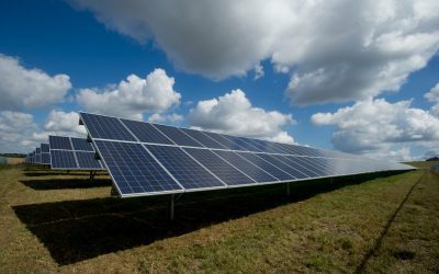
Climate Zones and Global Energy Needs: Solar, Wind, and Hydropower Potential
Climate zones are geographical areas that share similar weather patterns and climatic conditions. These zones are determined by factors such as temperature, precipitation and humidity. There are several different climate classification systems, but the most widely used is the Köppen climate classification, which divides the world into five primary climate groups: tropical, dry, temperate, continental and polar. Tropical climate zones are typically found near the equator and are characterised by high temperatures and heavy rainfall throughout the year. Dry climate zones, conversely, experience very little precipitation and are often found in desert regions. Temperate climate zones have moderate temperatures and distinct seasons, whilst continental climate zones have hot summers and cold winters. Finally, polar climate zones are characterised by extremely cold temperatures and little to no vegetation. Understanding climate zones is crucial for assessing the potential for renewable energy sources such as solar, wind and hydropower. Different climate zones offer unique opportunities and challenges for harnessing these renewable energy sources, making it essential to consider the specific characteristics of each zone when developing energy strategies. Summary Climate zones are determined by factors such as temperature, precipitation, and vegetation, and can be classified into categories such as tropical, temperate, and polar. Solar power potential is highest in tropical and desert climate zones due to the abundance of sunlight, making these areas ideal for solar energy production. Wind power potential is greatest in coastal and open plain climate zones, where strong and consistent winds can be harnessed for energy generation. Hydropower potential is highest in mountainous and riverine climate zones, where the presence of water bodies and elevation differences allow for...
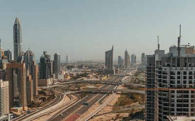
Discussing the challenges of balancing environmental protection with urban sprawl in temperate climate regions.
Urban sprawl is a phenomenon that has been increasing in temperate climate regions, as cities continue to expand and develop. This rapid growth of urban areas has significant implications for the environment, often resulting in the destruction of natural habitats and the loss of biodiversity. In temperate climate regions, where the climate is generally mild and the landscape is typically characterised by forests, grasslands, and wetlands, urban sprawl can have particularly detrimental effects on the environment. As cities grow, they encroach upon these natural areas, leading to habitat fragmentation and loss. This can have serious consequences for the flora and fauna that depend on these habitats for their survival, resulting in a decline in biodiversity. Furthermore, urban sprawl can also lead to increased water and air pollution, as well as the loss of green spaces and agricultural land. Consequently, it is essential to consider the environmental impact of urban sprawl in temperate climate regions and to develop strategies for sustainable urban development that can help to mitigate these effects. Urban sprawl is a complex issue that requires careful consideration of its environmental impact in temperate climate regions. As cities continue to expand, they often encroach upon natural habitats, leading to habitat fragmentation and loss. This can have serious consequences for the plants and animals that rely on these habitats for their survival, resulting in a decline in biodiversity. Additionally, urban sprawl can also lead to increased water and air pollution, as well as the loss of green spaces and agricultural land. Therefore, it is crucial to consider the environmental impact of urban sprawl in temperate climate regions and to...

Temperate Zones: Balancing Nature and Urbanization
Temperate zones are regions of the Earth situated between the tropics and the polar circles. These areas are characterised by moderate temperatures, distinct seasons and a diverse range of flora and fauna. The temperate zones harbour a variety of ecosystems, including forests, grasslands and wetlands, which support a rich array of plant and animal species. These regions are also significant for agriculture, providing fertile soil and a suitable climate for cultivating crops. The temperate zones are densely populated, with numerous major cities and urban areas located within them. Consequently, these regions face considerable challenges related to urbanisation, environmental degradation and the conservation of natural resources. It is essential to strike a balance between human development and the preservation of the unique ecosystems and biodiversity found in temperate zones. Summary Temperate zones are regions with moderate climate and distinct seasons, and are home to diverse ecosystems and species. Urbanization in temperate zones has led to habitat loss, pollution, and fragmentation of natural areas, impacting biodiversity and ecosystem functioning. Conservation efforts in temperate zones include protected areas, restoration projects, and sustainable land management practices to preserve and restore natural habitats. Biodiversity in temperate zones is rich and includes a wide variety of plant and animal species, many of which are endemic and at risk of extinction. Sustainable development in temperate zones involves balancing economic growth with environmental protection, promoting green infrastructure and sustainable resource management. The Impact of Urbanization on Temperate Zones The Destruction of Natural Habitats The expansion of urban areas results in the destruction of forests, wetlands, and other vital habitats. This can have a catastrophic impact on the...

Focusing on the importance of eco-tourism in tropical rainforests, tundras, and deserts, and the need for conservation.
Eco-tourism is a form of sustainable travel that focuses on experiencing natural areas whilst conserving the environment and improving the well-being of local communities. It is a responsible way of travelling to natural areas that conserves the environment and sustains the well-being of local people. Eco-tourism aims to educate travellers about the importance of preserving natural habitats and wildlife, whilst also providing economic benefits to local communities. This type of tourism promotes conservation, fosters respect for different cultures, and minimises the negative impact on the environment. Eco-tourism destinations often include national parks, wildlife reserves, and other protected areas where visitors can experience nature in its purest form. Eco-tourism has gained popularity in recent years as more people become aware of the environmental and social impact of traditional tourism. Travellers are seeking authentic and meaningful experiences that allow them to connect with nature and contribute to the preservation of natural habitats. Eco-tourism offers a way for people to explore the world whilst making a positive impact on the planet. By supporting eco-friendly accommodations, local guides, and sustainable tour operators, travellers can help protect fragile ecosystems and support the livelihoods of indigenous communities. Overall, eco-tourism provides a way for people to travel responsibly and contribute to the conservation of natural resources. Summary Eco-tourism promotes responsible travel and conservation in natural environments Eco-tourism in tropical rainforests helps protect biodiversity and supports local communities Tundras benefit from eco-tourism by raising awareness about climate change and wildlife conservation Eco-tourism in deserts offers opportunities for sustainable development and cultural exchange Conservation efforts in tropical rainforests focus on preserving endangered species and combating deforestation The Importance...
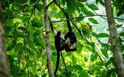
Eco-Tourism and Conservation in Fragile Climate Zones
Eco-tourism is a form of tourism that emphasises responsible travel to natural areas, with the aim of conserving the environment and enhancing the well-being of local communities. It is a rapidly expanding sector of the tourism industry, with an increasing number of travellers seeking authentic and sustainable experiences in fragile climate zones. These areas, such as rainforests, coral reefs, and polar regions, are particularly susceptible to the effects of climate change and human activity. Consequently, eco-tourism plays a vital role in promoting conservation and sustainable development in these regions. In fragile climate zones, eco-tourism can provide an alternative source of income for local communities, reducing their dependence on activities that damage the environment, such as logging or fishing. By creating economic incentives for conservation, eco-tourism can help safeguard biodiversity and natural habitats. However, it is crucial that eco-tourism is managed carefully to ensure that it does not contribute to further environmental degradation. This necessitates a balance between promoting tourism and protecting the delicate ecosystems that attract visitors to these areas in the first place. Summary Eco-tourism and conservation play a crucial role in protecting fragile climate zones and promoting sustainable development. Sustainable tourism in fragile climate zones is important for preserving biodiversity, protecting natural resources, and supporting local communities. Conservation in fragile climate zones faces challenges such as climate change, habitat destruction, and over-tourism, which threaten the delicate ecosystems. Successful examples of eco-tourism and conservation in fragile climate zones include community-based tourism initiatives, wildlife reserves, and sustainable travel practices. Strategies for responsible eco-tourism in fragile climate zones include promoting low-impact tourism, supporting local businesses, and educating visitors about environmental...
Analyzing how specific climate zones, such as tropical and subtropical, are prone to hurricanes, cyclones, and monsoons.
Climate zones are geographical areas with similar weather patterns, temperature ranges and environmental conditions. These zones are determined by a combination of factors, including latitude, altitude, proximity to bodies of water and prevailing wind patterns. Understanding climate zones is crucial for predicting weather patterns, agricultural practices and the impact of climate change on different regions. There are several main climate zones, including tropical, subtropical, temperate, polar and arid. Each of these zones has distinct characteristics that influence the flora, fauna and human activities within them. In this article, we shall focus on tropical and subtropical climate zones, exploring the unique features of each and the challenges they present in terms of extreme weather events such as hurricanes, cyclones and monsoons. Summary Climate zones categorise different regions based on their typical weather patterns and temperatures. Tropical climate zones are characterised by high temperatures, humidity, and heavy rainfall. Hurricanes in tropical climate zones are influenced by warm ocean waters and low atmospheric pressure. Subtropical climate zones experience milder temperatures and are prone to cyclones, which are intense low-pressure systems. Monsoons can affect different climate zones, bringing heavy rainfall and seasonal changes in wind patterns. Understanding Tropical Climate Zones Characteristics of Tropical Climate Zones The combination of warm temperatures and ample moisture creates ideal conditions for diverse ecosystems, including rainforests, savannas, and wetlands. Extreme Weather Events Tropical climate zones are also prone to extreme weather events such as hurricanes, typhoons, and monsoons. These phenomena are fuelled by the warm ocean waters and the Earth’s rotation, which create the perfect conditions for the formation of powerful storms. The impact of these events can...
Tropical Storms and Monsoons: The Role of Climate Zones in Extreme Weather
Climate zones are geographical areas with similar weather patterns, including temperature, humidity and precipitation. There are five primary climate zones: tropical, dry, temperate, continental and polar. Each zone has distinct characteristics that influence the type of weather experienced in that region. Tropical climate zones are located near the equator and experience high temperatures and humidity throughout the year. These regions typically have a wet and dry season, with heavy rainfall during the wet season. Dry climate zones are found in arid and semi-arid regions, with low precipitation and high temperatures. Temperate climate zones have moderate temperatures and distinct seasons, including warm summers and cold winters. Continental climate zones experience extreme temperature variations between summer and winter, with hot summers and cold winters. Polar climate zones are located near the North and South Poles and have extremely cold temperatures and little precipitation. Understanding climate zones is essential for predicting and preparing for weather patterns and extreme events such as tropical storms and monsoons. Each climate zone has its own unique characteristics that influence the formation and impact of these weather phenomena. Tropical Storms: Formation and Impact Tropical storms, also known as hurricanes or typhoons, are powerful weather systems that form over warm ocean waters in tropical climate zones. These storms are characterised by strong winds, heavy rainfall and storm surges, which can cause widespread destruction and loss of life. The formation of tropical storms is influenced by several factors, including warm ocean temperatures, high humidity and low wind shear. Tropical storms typically form when warm ocean waters evaporate and rise into the atmosphere, creating an area of low pressure. As...

Exploring how diverse climates have influenced the culture, clothing, architecture, and lifestyles of different regions.
The world is a diverse and varied place, with a wide range of climates and environments that have shaped the cultures and traditions of different regions. From the icy tundras of the Arctic to the sweltering deserts of the Middle East, each climate has had a profound impact on the way people live, work and interact with their surroundings. The influence of climate on culture can be observed in various aspects, including clothing choices and architectural styles. Understanding the ways in which climate shapes culture is essential for appreciating the rich tapestry of human experience that exists around the globe. The impact of climate on culture extends beyond the physical environment to encompass social and economic aspects of society. In regions with harsh climates, people have developed unique methods of survival and prosperity, leading to the establishment of distinct cultural practices and traditions. Examples include the nomadic herding cultures of Mongolia and the fishing communities of coastal regions, where the ways in which people interact with their environment are deeply intertwined with the local climate. By examining the ways in which climate has influenced different cultures, one can gain a deeper appreciation for the diversity of human experience and the resilience of people in adapting to their surroundings. Summary Diverse climates around the world have a significant influence on the cultural practices and traditions of different regions. Climate plays a crucial role in shaping the clothing and fashion choices of people, reflecting the need for practical and functional attire. Architecture in different regions is a reflection of the local climate, with designs and materials adapted to suit the environmental...