Thailand, a Southeast Asian nation known for its rich cultural heritage and vibrant landscapes, boasts a diverse terrain that significantly influences its climate, agriculture, and human settlements. The country’s topography is characterised by a mix of mountainous regions, fertile valleys, expansive plains, and plateaus, each contributing to the ecological and cultural tapestry of the nation. Spanning approximately 513,000 square kilometres, Thailand‘s geographical features range from the rugged peaks of the Himalayas in the north to the tropical beaches of the south, creating a unique interplay between natural beauty and human activity.
The varied terrain of Thailand not only shapes its physical landscape but also plays a crucial role in determining the livelihoods of its inhabitants. The distribution of natural resources, agricultural practices, and settlement patterns are all influenced by the topographical features of the land. Understanding the intricacies of Thailand’s terrain is essential for appreciating the country’s environmental diversity and the ways in which its people have adapted to their surroundings over centuries.
Summary
- Thailand’s terrain is diverse, consisting of mountains, valleys, lowlands, plains, and plateaus.
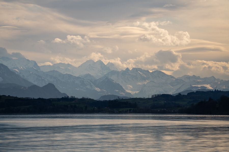
- The mountainous regions of Thailand are found in the northern and western parts of the country, with peaks reaching over 2,000 meters in height.
- The valleys and lowlands of Thailand are located in the central and northeastern regions, with fertile soil suitable for agriculture.
- The plains and plateaus of Thailand are mainly situated in the central and eastern parts of the country, providing important agricultural land.
- Thailand’s varied terrain has a significant impact on its climate and agriculture, influencing factors such as temperature, rainfall, and crop suitability.
The Mountainous Regions of Thailand
The mountainous regions of Thailand are predominantly found in the northern part of the country, where the landscape is dominated by the rugged terrain of the Thai highlands. This area is home to several significant mountain ranges, including the Himalayas, which extend into northern Thailand, and the Daen Lao Range. The highest peak in Thailand, Doi Inthanon, rises to an impressive 2,565 metres above sea level and is part of a national park that attracts both tourists and researchers alike.
The mountains are characterised by steep slopes, deep valleys, and a rich biodiversity that includes numerous endemic species. These mountainous areas are not only visually stunning but also play a vital role in the local climate. The elevation creates cooler temperatures compared to the lowlands, leading to distinct microclimates that support diverse ecosystems.
The forests that blanket these mountains are crucial for water retention and serve as watersheds for many rivers that flow down to the plains below. Additionally, the mountainous regions are home to various ethnic groups who have adapted their lifestyles to the challenging terrain, often engaging in agriculture that includes the cultivation of rice, maize, and cash crops such as coffee and tea.
The Valleys and Lowlands of Thailand
In contrast to the mountainous regions, Thailand’s valleys and lowlands present a different landscape that is characterised by fertile plains and river basins. The Chao Phraya River Valley is one of the most significant lowland areas in Thailand, providing essential irrigation for agriculture and serving as a vital transportation route. This valley is often referred to as the “rice bowl” of Thailand due to its extensive rice cultivation, which has been a staple food source for centuries.
The alluvial soil deposited by the river contributes to the fertility of the land, making it ideal for farming.
These areas are particularly important for agriculture, as they provide not only rice but also fruits, vegetables, and other crops that sustain local communities.
The valleys are often densely populated, with towns and cities developing along major rivers due to their accessibility and resources. This concentration of human activity has led to significant cultural development, with vibrant markets and festivals celebrating agricultural traditions.
The Plains and Plateaus of Thailand
Thailand’s plains and plateaus offer yet another dimension to its topographical diversity. The Korat Plateau, located in the northeastern region of Thailand, is one of the largest plateaus in the country. This area is characterised by its relatively flat terrain interspersed with hills and valleys.
The plateau is primarily composed of laterite soil, which can be less fertile than the alluvial soils found in river valleys; however, it supports a unique ecosystem that includes grasslands and scrub forests. The plains surrounding these plateaus are often used for agriculture, particularly for growing crops such as cassava and sugarcane. The agricultural practices in these regions have evolved over time, with farmers adapting to the soil conditions and climate variations.
The plateau’s elevation also influences local weather patterns, leading to distinct seasonal changes that affect crop yields. In addition to agriculture, these areas are rich in mineral resources, which have been exploited for economic development but also raise concerns about environmental sustainability.
The Impact of Thailand’s Terrain on Climate and Agriculture
Thailand’s diverse terrain has a profound impact on its climate patterns, which in turn affects agricultural practices across the country. The mountainous regions experience cooler temperatures and higher rainfall compared to the lowlands, creating microclimates that allow for a variety of crops to be cultivated. For instance, highland farmers often grow temperate crops such as strawberries and vegetables that thrive in cooler conditions.
Conversely, the lowland areas benefit from warmer temperatures and abundant water supply from rivers, making them ideal for rice cultivation. The interplay between terrain and climate also influences seasonal agricultural practices. In northern Thailand, farmers may rely on rain-fed irrigation during the wet season while utilising more sophisticated irrigation systems during drier months.
In contrast, farmers in the central plains often engage in double or triple cropping cycles due to the fertile alluvial soils and consistent water supply from rivers. This adaptability highlights how deeply intertwined Thailand’s agricultural practices are with its varied topography.
Human Settlements in Different Terrain Types

Mountainous Regions
In mountainous areas, communities often consist of small villages where residents engage in subsistence farming or traditional crafts. These settlements are typically isolated due to difficult access routes but benefit from rich natural resources such as timber and medicinal plants found in surrounding forests.
Urban Centres
In contrast, urban centres have flourished in lowland areas where fertile land and water resources support larger populations. Cities like Bangkok have emerged as bustling metropolises due to their strategic locations along major rivers. The accessibility provided by these waterways has facilitated trade and commerce while also attracting migrants from rural areas seeking better economic opportunities.
Impact of Urbanisation
As a result, urbanisation has led to significant changes in land use patterns, with agricultural land being converted into residential and commercial developments.
Conservation and Protection of Thailand’s Diverse Terrain
The rich diversity of Thailand’s terrain necessitates concerted efforts towards conservation and protection to ensure sustainable development for future generations. Various national parks and protected areas have been established across the country to safeguard unique ecosystems and biodiversity hotspots. For instance, Doi Inthanon National Park not only protects the highest peak but also serves as a critical watershed for surrounding regions.
However, challenges remain as urbanisation and agricultural expansion threaten natural habitats.
Additionally, pollution from urban centres impacts water quality in rivers that flow through both rural and urban landscapes.
To address these issues, conservation initiatives often involve local communities in sustainable practices that balance economic needs with environmental stewardship.
Appreciating the Varied Terrain of Thailand
Thailand’s varied terrain is a testament to its ecological richness and cultural diversity. From the majestic mountains that cradle unique ecosystems to the fertile valleys that sustain agricultural livelihoods, each geographical feature plays a vital role in shaping the lives of its inhabitants. Understanding this intricate relationship between terrain and human activity is essential for fostering sustainable development that respects both nature and culture.
As Thailand continues to navigate modern challenges such as climate change and urbanisation, appreciating its diverse landscapes becomes increasingly important. By recognising the value of its natural resources and promoting conservation efforts, Thailand can ensure that its varied terrain remains a source of pride and sustenance for generations to come.
FAQs
What is the terrain and topography of Thailand like?
Thailand’s terrain is diverse, consisting of mountains, valleys, and plains. The northern region is mountainous, with the highest peak being Doi Inthanon at 2,565 meters. The central region is characterized by fertile plains, while the southern region is known for its coastal plains and rugged coastline.
How do the mountains, valleys, and plains in Thailand impact the country?
The diverse terrain and topography of Thailand have a significant impact on the country’s climate, agriculture, and biodiversity. The mountains influence weather patterns and support a variety of flora and fauna, while the plains are ideal for agriculture, particularly rice cultivation.
What are some notable mountain ranges in Thailand?
Thailand is home to several notable mountain ranges, including the Daen Lao Range, the Phi Pan Nam Range, and the Tanaosri Range. These mountain ranges contribute to the country’s rugged and picturesque landscape.
How does the topography of Thailand influence tourism and outdoor activities?
The varied topography of Thailand offers a wide range of outdoor activities for tourists, including trekking, rock climbing, and wildlife spotting. The mountains, valleys, and plains provide diverse landscapes for adventure seekers and nature enthusiasts to explore.


