Tunisia, a North African nation, boasts a diverse and captivating landscape that reflects its rich geological history and climatic variations. The country’s terrain is a tapestry woven from mountains, valleys, plains, and deserts, each contributing to the unique ecological and cultural fabric of the region. Spanning approximately 163,610 square kilometres, natural environment but also influences the livelihoods, traditions, and lifestyles of its inhabitants. The interplay between these various landforms creates a dynamic ecosystem that supports a wide array of flora and fauna. The northern regions are characterised by lush greenery and fertile valleys, while the southern parts transition into arid desert landscapes.
This stark contrast is a result of Tunisia’s climatic zones, which vary from Mediterranean in the north to semi-arid and desert conditions in the south. Understanding Tunisia’s terrain is essential for appreciating its agricultural practices, biodiversity, and the historical significance of its landscapes.
Summary
- Tunisia’s terrain is diverse, ranging from mountains to coastal plains and salt flats.
- The Atlas Mountains are the highest peaks in Tunisia, offering stunning views and challenging hikes.
- The Medjerda Valley is the fertile heart of Tunisia, providing rich agricultural land and a vital water source.
- The Sahel Region consists of Tunisia’s coastal plains, offering beautiful beaches and important economic activity.
- The Chott el Jerid is Tunisia’s salt flats, creating a unique and otherworldly landscape.
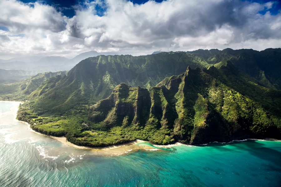
The Atlas Mountains: Tunisia’s Highest Peaks
Unique Ecosystems and Biodiversity
This area is renowned for its rich biodiversity, including endemic species of plants and animals that thrive in its unique microclimates. The Atlas Mountains are characterised by rugged terrain, steep slopes, and deep valleys. The region is home to various ecosystems, ranging from Mediterranean forests to alpine meadows.
Water Catchment and Cultural Significance
The mountains also play a crucial role in water catchment, feeding rivers that flow into the fertile plains below. The cultural significance of the Atlas Mountains cannot be overstated; they have been inhabited by various Berber tribes for centuries, who have adapted their lifestyles to the challenging environment.
Traditional Practices and Harmony with Nature
Traditional practices such as agriculture and animal husbandry are still prevalent in these highlands, showcasing a harmonious relationship between the people and their landscape.
The Medjerda Valley: The Fertile Heart of Tunisia
The Medjerda Valley is often referred to as the agricultural heart of Tunisia due to its fertile soil and abundant water resources. This valley is formed by the Medjerda River, which flows from the Atlas Mountains through the northern part of the country before emptying into the Gulf of Tunis. The river’s basin is characterised by alluvial plains that support a variety of crops, including olives, cereals, and fruits.
The region’s agricultural productivity is further enhanced by traditional irrigation techniques that have been developed over centuries. The Medjerda Valley is not only significant for its agricultural output but also for its historical importance. It has been a cradle of civilisations since ancient times, with archaeological sites scattered throughout the region that testify to its long-standing human presence.
The valley has served as a vital trade route connecting different parts of Tunisia and beyond, facilitating cultural exchange and economic development. Today, it remains a vital area for both local farmers and national agriculture, contributing significantly to Tunisia’s economy.
The Sahel Region: Tunisia’s Coastal Plains
The Sahel region stretches along Tunisia’s eastern coastline, characterised by its gentle rolling hills and fertile plains that transition into sandy beaches along the Mediterranean Sea. This area is known for its agricultural productivity, particularly in the cultivation of olives and citrus fruits. The Mediterranean climate, with its hot summers and mild winters, provides ideal conditions for farming, making the Sahel one of Tunisia’s most important agricultural zones.
In addition to agriculture, the Sahel region is also a hub for tourism due to its picturesque coastal towns such as Sousse and Monastir. These towns are steeped in history, featuring ancient medinas, impressive mosques, and remnants of Roman architecture. The combination of natural beauty and cultural heritage attracts visitors from around the world, contributing to the local economy.
The Sahel’s coastal plains not only support agriculture but also play a crucial role in Tunisia’s tourism industry, highlighting the multifaceted importance of this region.
The Chott el Jerid: Tunisia’s Salt Flats
Chott el Jerid is one of the most striking geographical features in Tunisia, known for its vast salt flats that stretch across the landscape like a shimmering white expanse. Located in the southwestern part of the country, this saline depression covers an area of approximately 5,000 square kilometres. During the dry season, the flat surface becomes a dazzling mirror reflecting the sky, while during periods of rain, it transforms into a temporary lake teeming with life.
The salt flats have significant economic importance as well; they are harvested for salt production, which has been a traditional industry in Tunisia for centuries. The unique ecosystem of Chott el Jerid supports various species of birds and other wildlife that have adapted to this harsh environment. Additionally, the area holds cultural significance for local communities who have historically relied on its resources for their livelihoods.
The stark beauty of Chott el Jerid has also made it a popular destination for photographers and adventurers seeking to experience one of Tunisia’s most extraordinary landscapes.
The Grand Erg Oriental: Tunisia’s Sand Dunes
Unique Landscape and Climate
The Grand Erg Oriental is not just a barren desert; it is home to a variety of flora and fauna that have adapted to survive in this arid environment. Species such as date palms and acacia trees can be found in oases scattered throughout the dunes, providing vital resources for both wildlife and human inhabitants. Nomadic tribes have historically traversed these sands, relying on their deep knowledge of the terrain for survival.
Wildlife and Human Inhabitants
The region’s unique landscape and climate support a range of wildlife, including species that have adapted to the harsh desert conditions. In addition, the Grand Erg Oriental has been home to various human inhabitants throughout history, from nomadic tribes to modern-day settlers.
Visitors can experience the thrill of exploring the vast expanse of sand dunes while learning about the region’s rich history and cultural significance.
The Kroumirie Mountains: Tunisia’s Northern Border
The Kroumirie Mountains form part of Tunisia’s northern border with Algeria and are known for their lush forests and rich biodiversity. This mountainous region is characterised by steep slopes covered with dense vegetation, including cork oak forests that are among the most extensive in North Africa. The Kroumirie Mountains are not only important for their ecological value but also serve as a critical watershed for many rivers that flow into the Mediterranean Sea.
The Kroumirie Mountains are home to various endemic species of plants and animals, making them a hotspot for biodiversity conservation efforts. The region has been designated as protected areas to preserve its unique ecosystems from threats such as deforestation and urbanisation. Additionally, these mountains hold cultural significance for local communities who have traditionally relied on their resources for sustenance and livelihood.
The Kroumirie Mountains exemplify the intricate relationship between nature and culture in Tunisia, highlighting the importance of preserving such landscapes for future generations.
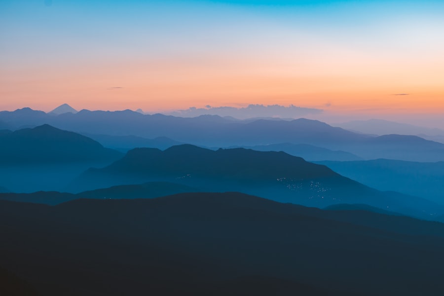
The Dorsale: Tunisia’s Central Ridge
The Dorsale mountain range runs through central Tunisia, acting as a backbone that divides the country into northern and southern regions. This ridge is characterised by rugged terrain and high peaks that contribute to Tunisia’s diverse climate patterns. The Dorsale plays a crucial role in influencing rainfall distribution across the country; areas on its northern slopes receive more precipitation compared to those on the southern side.
The Dorsale is not only significant for its geographical features but also for its cultural heritage. It has been inhabited by various communities throughout history who have adapted their lifestyles to the mountainous environment. Traditional practices such as herding and agriculture are still prevalent in this region today.
Moreover, archaeological sites dotting the Dorsale provide insight into Tunisia’s rich history, showcasing remnants from different civilisations that have thrived in this area over millennia. The Dorsale stands as a testament to Tunisia’s complex interplay between geography, culture, and history, making it an essential component of the nation’s identity.
FAQs
What is the terrain and topography of Tunisia like?
Tunisia’s terrain is diverse, with mountains, valleys, and plains. The northern part of the country is characterized by the Atlas Mountains, while the central and southern regions consist of plateaus and desert landscapes.
What are the major mountain ranges in Tunisia?
The major mountain ranges in Tunisia include the Atlas Mountains, which run along the northern border with Algeria, and the Tell Atlas, which extends into the northeastern part of the country.
Are there any significant valleys in Tunisia?
Yes, Tunisia is home to several significant valleys, including the Medjerda Valley, which is the country’s most important river valley and a key agricultural region. The Tamerza Valley and the Mides Valley are also notable for their stunning landscapes and natural beauty.
What are the main plains in Tunisia?
The main plains in Tunisia include the Cap Bon Peninsula, which is located in the northeastern part of the country, and the Sahel region, which lies between the Atlas Mountains and the Mediterranean Sea. These plains are important agricultural areas and contribute to the country’s economy.


