World Geography
Geography is the study of the Earth’s landscapes, environments, and the relationships between people and their surroundings. It encompasses both the physical aspects of the Earth, such as its landforms, bodies of water, and climate, as well as the human aspects, including population distribution, cultures, and economies. World geography is a broad field that seeks to understand the complexities of our planet and how humans interact with it. By studying world geography, we can gain a deeper appreciation for the diversity of our planet and the interconnectedness of its various regions.
Geography is a multidisciplinary field that draws on elements of physical science, social science, and humanities. It involves the use of maps, spatial analysis, and geographic information systems (GIS) to understand the Earth’s surface and the processes that shape it. World geography also encompasses the study of human geography, which examines the ways in which people and their activities are distributed across the Earth. By understanding world geography, we can better appreciate the environmental, cultural, and economic challenges facing different regions of the world. This knowledge is crucial for addressing global issues such as climate change, resource management, and international development.
The Five Oceans and Seven Continents
The Earth’s surface is divided into five major oceans: the Pacific, Atlantic, Indian, Southern (or Antarctic), and Arctic Oceans. These vast bodies of water play a crucial role in regulating the Earth’s climate and supporting diverse marine ecosystems. The oceans also serve as important transportation routes and a source of food and other natural resources for human societies around the world.
In addition to the oceans, the Earth’s landmasses are divided into seven continents: Africa, Antarctica, Asia, Europe, North America, Australia (or Oceania), and South America. Each continent has its own unique physical and cultural characteristics, shaped by millions of years of geological processes and human history. From the deserts of Africa to the rainforests of South America, the continents offer a rich tapestry of landscapes and environments for exploration and study.
Major Mountain Ranges and Deserts
The Earth’s surface is also marked by major mountain ranges and deserts that have shaped the planet’s physical and cultural landscapes. The Himalayas, for example, are the highest mountain range in the world and are home to diverse ecosystems and cultures in countries such as India, Nepal, and Bhutan. The Andes in South America, the Rockies in North America, and the Alps in Europe are other prominent mountain ranges that have influenced human settlement patterns and economic activities.
Deserts cover about one-third of the Earth’s land surface and are characterized by low precipitation and extreme temperatures. The Sahara Desert in Africa is the largest hot desert in the world, while the Gobi Desert in Asia is one of the largest cold deserts. Deserts are not only home to unique flora and fauna but have also been important trade routes and cultural crossroads throughout history.
Climate Zones and Biomes
The Earth’s climate is influenced by a variety of factors, including latitude, altitude, ocean currents, and prevailing winds. As a result, the planet is divided into different climate zones, each with its own characteristic weather patterns and ecosystems. The equator, for example, experiences a tropical climate with high temperatures and heavy rainfall, while the polar regions have a cold and dry climate.
These climate zones give rise to different biomes, or large ecological areas characterized by distinct plant and animal communities. The tropical rainforest biome, found near the equator, is home to a diverse array of species and is vital for regulating the Earth’s climate. The grasslands biome, found in regions such as the African savannah and North American prairies, supports grazing animals and has been important for human agriculture throughout history.
Human Geography and Population Distribution
Human geography examines the ways in which people and their activities are distributed across the Earth’s surface. It encompasses topics such as population growth, migration patterns, urbanization, and cultural diversity. Understanding human geography is crucial for addressing global challenges such as poverty, inequality, and environmental degradation.
Population distribution is uneven across the world, with some regions experiencing rapid population growth while others are declining. The majority of the world’s population lives in Asia, particularly in countries such as China and India. Urban areas are also growing rapidly, with more than half of the world’s population now living in cities. This trend has significant implications for infrastructure development, resource management, and social inequality.
Historical and Cultural Geography
Historical geography examines how human activities have shaped the Earth’s landscapes over time. It explores topics such as colonialism, trade routes, and the rise and fall of empires. Cultural geography focuses on how human cultures have developed in different regions of the world and how they interact with their environments.
The Silk Road, for example, was an ancient trade route that connected China with Europe and facilitated the exchange of goods, ideas, and technologies across Eurasia. This historical trade route had a profound impact on the development of cultures and economies along its path. Similarly, cultural geographers study how different societies have adapted to their environments through practices such as agriculture, architecture, and religious beliefs.
The Importance of Geographic Knowledge
Geographic knowledge is crucial for addressing global challenges such as climate change, resource management, and international development. By understanding world geography, we can better appreciate the environmental, cultural, and economic challenges facing different regions of the world. This knowledge is crucial for addressing global issues such as climate change, resource management, and international development.
Geographic knowledge also helps us to understand our interconnectedness with other regions of the world. By studying world geography, we can gain a deeper appreciation for the diversity of our planet and the interconnectedness of its various regions. This understanding can foster a sense of global citizenship and empathy for people from different cultures and backgrounds.
In conclusion, world geography is a complex and multifaceted field that encompasses both physical and human aspects of the Earth’s landscapes. By studying world geography, we can gain a deeper appreciation for the diversity of our planet and the interconnectedness of its various regions. This knowledge is crucial for addressing global challenges such as climate change, resource management, and international development. It also helps us to understand our interconnectedness with other regions of the world and fosters a sense of global citizenship.
FAQs
What is world geography?
World geography is the study of the Earth’s landscapes, environments, and the relationships between people and their environments. It encompasses the physical features of the Earth, as well as the human activity that takes place on it.
Why is world geography important?
World geography is important because it helps us understand the world around us. It provides insights into the physical and human processes that shape our planet, and helps us make informed decisions about how to interact with our environment.
What are the main branches of world geography?
The main branches of world geography include physical geography, which focuses on the Earth’s natural features and processes, and human geography, which examines the relationships between people and their environments.
How does world geography impact our daily lives?
World geography impacts our daily lives in numerous ways, from influencing the weather and climate we experience, to shaping the availability of natural resources and influencing the distribution of populations and cultures around the world.
What are some key concepts in world geography?
Key concepts in world geography include location, place, human-environment interaction, movement, and region. These concepts help geographers understand and interpret the world around them.

History of Fiji
Fiji, an archipelago of over 300 islands in the South Pacific, has a rich history dating back over 3,000 years. The first settlers are believed to have arrived from Southeast Asia and Melanesia, bringing with them their unique culture and traditions. These early inhabitants were skilled in fishing, agriculture, and pottery making, and they established thriving communities across the islands. In the late 18th century, European explorers, including the famous Captain James Cook, began to visit the islands. This marked the beginning of European influence in Fiji. In 1874, Fiji officially became a British colony, and this period of colonization had a profound impact on the islands. The British brought with them new technologies, such as railways and telegraph lines, and introduced commercial agriculture, particularly sugar cane production. They also brought Indian laborers to work on the sugar plantations, leading to a significant Indian population in Fiji. This period of colonization also saw the introduction of Christianity to the islands, which had a lasting impact on Fijian society. The early settlement and colonization of Fiji laid the foundation for the diverse and multicultural society that exists in the country today. The blending of indigenous Fijian, Indian, European, and other cultures has created a unique and vibrant national identity. The legacy of British colonization is still evident in many aspects of Fijian life, from the legal and political systems to the language and education. Summary Early settlement and colonization in Fiji began around 1500 BCE, with the arrival of the Lapita people. British rule in Fiji began in 1874, and the country gained independence in 1970. World War II had...

Population Density of Fiji
Fiji, a beautiful island nation located in the South Pacific, is known for its stunning natural landscapes, vibrant culture, and warm hospitality. With a population of approximately 900,000 people, Fiji is a diverse and multicultural society, with indigenous Fijians, Indo-Fijians, and other ethnic groups coexisting harmoniously. The population density of Fiji is around 49 people per square kilometre, making it one of the most sparsely populated countries in the world. However, despite its relatively low population density, Fiji faces unique challenges and opportunities related to its population distribution. Understanding the factors affecting population density in Fiji, the impact on infrastructure and services, and the government’s policies and initiatives to manage population density is crucial for sustainable development and planning for the future. Summary Fiji’s population density is relatively low compared to other countries, with most of the population concentrated in urban areas. Factors affecting population density in Fiji include geographical features, economic opportunities, and government policies. Urban population density in Fiji is significantly higher than rural population density, leading to challenges in infrastructure and service provision. High population density in urban areas puts pressure on infrastructure and services, leading to issues such as traffic congestion and inadequate housing. The government of Fiji is implementing policies and initiatives to manage population density, including urban planning and rural development programs. Factors Affecting Population Density in Fiji Several factors contribute to the population density in Fiji. One of the primary factors is the geographical layout of the islands. The rugged terrain and mountainous interiors of the islands make large areas uninhabitable, leading to uneven population distribution. The coastal areas and fertile river...

Fiji
Fiji (Republic of the Fiji Islands) Capital: Suva Population (Estimated July 2012): 890,057 Area: 18,272 km2 or 7,055 mi2 Currency: Fiji dollar (F$) Official Language: English and Fijian Political Information: Parliamentary Republic Official Religion: No Official Religion (approximately 55.4% of the population are Protestant, 27.9% are Hindu, 9.1% are Roman Catholic, 6.3% are Muslim, 0.6% have other religious beliefs and 0.7% have no religious beliefs) Highest Mountain: Tomanivi at 1,324m or 4,344ft GDP Official Exchange Rate (OER is more precise at gauging a countries economic power) (Estimated 2011): $3.4 billion (US$) or (GBP) GDP (OER) Per Capita (per member of the population estimated 2011): (US$) or (GBP) GDP Purchasing Power Parity (PPP is good for gauging living conditions and use of resources but not as accurate as OER. This data has been calculated based on the sum value of all goods and services produced in the country valued at prices prevailing in the United States) (Estimated 2011): $4.08 billion (US$) or (GBP) GDP (PPP) Per Capita (per member of the population estimated 2011): $4,600 (US$) or (GBP) Time Zone (GMT/UTC): +12:00 Wildlife: Counties/Provinces/States: 4 divisions and 1 dependency*; Central, Eastern, Northern, Rotuma*, Western Leaders: President Ratu Epeli Nailatikau with Interim Prime Minister Voreqe Bainmarama. Additional: Independence from the UK gained on the 10th of October 1970 and celebrated on the second Monday in October. Sources: CIA World Fact Book, Encyclopaedia Britannica. Fiji Fiji is an archipelago of more than 300 islands located in the South Pacific Ocean. It is known for its stunning natural beauty, rich culture, and warm hospitality. The capital city, Suva, is located on the largest island, Viti Levu. The official languages spoken in...

Political Boundaries of Ethiopia: Provinces, Districts, or Historical Boundaries.
Ethiopia, located in the Horn of Africa, is a landlocked country with a rich history and diverse cultural heritage. The political boundaries of Ethiopia have evolved over centuries, shaped by historical, cultural, and administrative factors. The country is bordered by Eritrea to the north, Djibouti and Somalia to the east, Kenya to the south, and South Sudan and Sudan to the west. The political boundaries of Ethiopia have been a subject of historical significance, as they have been influenced by various empires, kingdoms, and colonial powers. The current political boundaries of Ethiopia were established in the 20th century, following the country’s independence from Italian occupation in 1941. The political boundaries of Ethiopia play a crucial role in shaping the country’s administrative divisions, governance structure, and cultural diversity. Ethiopia is a federal state with a complex system of administrative divisions, including regions, zones, and woredas (districts). The political boundaries of Ethiopia are defined by its nine ethnically-based regional states, two chartered cities, and five autonomous regions. These administrative divisions are designed to accommodate the diverse ethnic groups and cultures within the country. The political boundaries of Ethiopia reflect the government’s commitment to decentralised governance and regional autonomy. The regional states have their own constitutions, governments, and legislative powers, which allows them to address local issues and promote cultural diversity. The administrative divisions of Ethiopia are essential for ensuring effective governance, resource allocation, and service delivery across the country. The political boundaries of Ethiopia are a reflection of its commitment to promoting unity in diversity and accommodating the needs of its diverse population. Summary Ethiopia’s political boundaries have evolved over time...

Natural Resources of Ethiopia: Where Natural Resources are Located in Ethiopia
Ethiopia, located in the Horn of Africa, is a country rich in natural resources. From fertile agricultural land to abundant mineral deposits, Ethiopia’s natural resources play a crucial role in the country’s economy and livelihoods of its people. The diverse landscape of Ethiopia, which includes highlands, lowlands, and plateaus, provides a wide range of natural resources that contribute to the country’s development and sustainability. With a population of over 110 million people, the sustainable management and utilization of these natural resources are essential for the country’s future growth and prosperity. Ethiopia’s natural resources are not only vital for its economy but also for its cultural and ecological significance. The country’s rich biodiversity, including unique wildlife and plant species, makes it a hotspot for conservation efforts and ecotourism. Additionally, Ethiopia’s water resources, including rivers, lakes, and underground aquifers, are crucial for agriculture, energy production, and human consumption. Understanding and harnessing these natural resources in a sustainable manner is essential for Ethiopia’s continued development and environmental preservation. Summary Ethiopia is rich in natural resources, including agriculture, minerals, water, energy, and wildlife. The country has a large amount of arable land, making agriculture a key resource for the economy. Ethiopia has significant mineral resources, including gold, platinum, and tantalum. The country’s water resources, including rivers and lakes, are crucial for agriculture and energy production. Ethiopia has diverse wildlife and biodiversity, but faces challenges in conservation efforts due to deforestation and habitat loss. Agriculture and Arable Land Agriculture is the backbone of Ethiopia’s economy, employing over 80% of the population and contributing significantly to the country’s GDP. The fertile highlands and lowlands of...

Climate Zones Of Ethiopia: Different Climate Regions Of Ethiopia
Ethiopia is a country located in the Horn of Africa, and it is known for its diverse climate zones. The country’s topography and geographical location contribute to the variation in climate across different regions. Ethiopia can be divided into five main climate zones: highland, lowland, desert, semi-arid, and tropical. Each of these climate zones has its own unique characteristics, which have a significant impact on the country’s agriculture, economy, and overall way of life. Understanding the different climate zones in Ethiopia is crucial for various reasons, including agricultural planning, resource management, and disaster preparedness. Summary Ethiopia has diverse climate zones, including highland, lowland, desert, semi-arid, and tropical. The highland climate zone is characterised by cool temperatures and abundant rainfall, making it suitable for agriculture. The lowland climate zone experiences high temperatures and limited rainfall, posing challenges for agriculture and water availability. The desert climate zone is extremely hot and dry, with very little vegetation and limited human habitation. The semi-arid climate zone has moderate temperatures and low rainfall, making it suitable for certain types of agriculture and pastoralism. The tropical climate zone is characterised by high temperatures and heavy rainfall, supporting lush vegetation and diverse wildlife. Understanding Ethiopia’s climate zones is important for agriculture, water resource management, and environmental conservation efforts. Highland Climate Zone The highland climate zone in Ethiopia is characterized by its cool temperatures and moderate rainfall. This region is located in the central and northern parts of the country, including the famous Ethiopian Highlands. The highland climate zone is known for its lush green landscapes, fertile soil, and abundant water sources. The temperatures in this region...

Terrain and Topography of Ethiopia: mountains, valleys, and plains.
Ethiopia, located in the Horn of Africa, is a land of diverse and stunning terrain. The country’s topography is characterized by high plateaus, rugged mountains, deep valleys, and vast lowlands. The varied landscape of Ethiopia has been shaped by geological forces, including the Great Rift Valley, which runs through the country from the northeast to the southwest. This diverse terrain has not only influenced the country’s climate and biodiversity but has also played a significant role in shaping Ethiopian culture and history. The topography of Ethiopia is a result of tectonic activity and volcanic eruptions that have occurred over millions of years. The country is situated on the East African Rift, a tectonic plate boundary where the African Plate is splitting into two, creating the Great Rift Valley. This geological phenomenon has led to the formation of highlands, mountains, and lowlands, each with its own unique characteristics. The diverse terrain of Ethiopia has also contributed to the country’s rich natural resources, including fertile soils, mineral deposits, and abundant water sources. This has made Ethiopia a land of great agricultural potential and natural beauty. Summary Ethiopia’s terrain is diverse, ranging from highlands to lowlands and unique landforms. The Great Rift Valley in Ethiopia is a land of great diversity, with lakes, volcanoes, and unique wildlife. The Ethiopian Highlands are home to majestic mountains, including the Simien Mountains, and have a significant impact on the country’s climate and agriculture. The lowlands of Ethiopia offer vast plains and unique ecosystems, such as the Danakil Depression, one of the hottest and lowest places on Earth. The unique landforms of Ethiopia, such as the...

History of Ethiopia
Ethiopia, located in the Horn of Africa, has a rich and ancient history that dates back to prehistoric times. The region has been inhabited by various ethnic groups for thousands of years, with evidence of early human settlement dating back to the Lower Paleolithic era. The earliest known civilization in Ethiopia was the D’mt kingdom, which emerged around the 8th century BCE. The D’mt kingdom was a powerful and influential state that controlled trade routes and engaged in commerce with other ancient civilizations such as Egypt and Arabia. The kingdom was known for its advanced agricultural practices, sophisticated architecture, and intricate pottery and metalwork. Following the decline of the D’mt kingdom, the region was home to a number of other ancient civilizations, including the Aksumite Empire. The Aksumite Empire, which emerged around the 1st century CE, was one of the most powerful and influential states in the ancient world. It was known for its advanced agricultural techniques, impressive architecture, and extensive trade networks that stretched across the Red Sea to Arabia and the Mediterranean. The Aksumites also developed their own unique writing system, known as Ge’ez, which is still used in the Ethiopian Orthodox Church today. The Aksumite Empire reached its peak during the 4th century CE, when it controlled much of the Horn of Africa and parts of southern Arabia. The empire’s decline began in the 7th century CE, due to a combination of factors including environmental changes, economic decline, and the rise of Islamic power in the region. Summary Early civilizations in Ethiopia date back to the pre-Aksumite period, with evidence of advanced societies and trade networks....

Population Density of Ethiopia
Ethiopia, located in the Horn of Africa, is the second-most populous country on the continent, with a population of over 115 million people. The country’s population density is unevenly distributed, with the majority of the population concentrated in the highland areas and along major river valleys. The population density in Ethiopia is influenced by a variety of factors, including geography, climate, and historical settlement patterns. Understanding the dynamics of population density in Ethiopia is crucial for policymakers and planners to effectively manage resources and infrastructure to support the growing population. Ethiopia’s population density is a complex interplay of various factors, including natural resources, economic opportunities, and historical settlement patterns. The country’s diverse geography, which includes highlands, lowlands, and plateaus, has a significant impact on population distribution. The highlands, with their fertile soil and temperate climate, have historically attracted a larger population, while the lowlands and arid regions have lower population densities due to harsh environmental conditions. Additionally, historical settlement patterns, such as the establishment of ancient cities and trade routes, have also influenced population distribution in Ethiopia. As the country continues to experience rapid population growth, understanding the factors that influence population density is essential for sustainable development and resource management. Summary Ethiopia’s population density is the measure of the number of people living per square kilometre of land. Factors influencing population density in Ethiopia include climate, natural resources, and economic opportunities. Regional variations in population density exist, with higher densities in urban areas and lower densities in rural areas. High population density in Ethiopia impacts infrastructure and resources, leading to strain on services and competition for resources. Challenges...

Cultural or Historical Sites of Ethiopia: Important Cultural Landmarks or Historical Sites in Ethiopia
Ethiopia is a country rich in cultural and historical heritage, with a diverse range of sites that showcase its ancient and medieval history. From rock-hewn churches to walled cities, Ethiopia’s cultural and historical sites offer a glimpse into the country’s rich and vibrant past. These sites are not only important for their historical significance but also for their architectural and artistic value, making them a must-visit for anyone interested in history and culture. Ethiopia’s cultural and historical sites are spread across the country, each offering a unique insight into the country’s past. From the ancient city of Aksum to the walled city of Harar, these sites are a testament to Ethiopia’s rich and diverse history. Whether you’re interested in ancient architecture, religious history, or archaeological wonders, Ethiopia’s cultural and historical sites have something to offer for everyone. In this article, we will explore some of the most significant cultural and historical sites in Ethiopia, delving into their history, significance, and the experiences they offer to visitors. Summary Ethiopia is home to a wealth of cultural and historical sites that showcase the country’s rich heritage and ancient traditions. The Rock-Hewn Churches of Lalibela are a UNESCO World Heritage site and a remarkable example of Ethiopian architecture and religious devotion. The Royal Enclosure of Gondar is a complex of castles and palaces that reflects the opulence and power of Ethiopia’s former emperors. The Fasil Ghebbi in Gondar is a fortress-city that served as the royal residence and is known for its unique blend of Ethiopian and Portuguese architectural styles. The Aksum Obelisks and Archaeological Site offer a glimpse into the ancient...
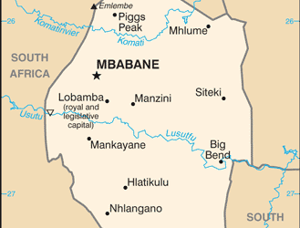
Eswatini
Eswatini (Formerly Swaziland) Capital: Mbabane (Administrative, Judicial) Lobamba (Legislative) Population (Estimated July 2012): 1,386,914 Area: 17,364km2 or 6,704mi2 Currency: Lilangeni5 (Plural Emalangeni [E]) Official Language: Swati (Swazi); English Political Information: Official Religion: No Official Religion(approximately 40% of the population are Zionist, 20% are Roman Catholic, 10% are Muslim and 30% have other religious beliefs) Highest Mountain: Mount Mlembe at 1,862m or 6,109ft GDP Official Exchange Rate (OER is more precise at gauging a countries economic power) (Estimated 2011): $3.9 billion (US$) or (GBP) GDP (OER) Per Capita (per member of the population estimated 2011): (US$) or (GBP) GDP Purchasing Power Parity (PPP is good for gauging living conditions and use of resources but not as accurate as OER. This data has been calculated based on the sum value of all goods and services produced in the country valued at prices prevailing in the United States) (Estimated 2011): $6.313 billion (US$) or (GBP) GDP (PPP) Per Capita (per member of the population estimated 2011): $5,400 (US$) or (GBP) Time Zone (GMT/UTC): +2:00 Wildlife: Counties/Provinces/States: 4 districts; Hhohho, Lubombo, Manzini, Shiselweni Leaders: King Mswati III; Prime Minister Barnabas Sibusiso Dlamini Additional: Gained independence from the U.K. on the 6th of September 1968. Sources: CIA World Fact Book, Encyclopaedia Britannica. Eswatini Eswatini, formerly known as Swaziland, is a small landlocked country located in Southern Africa. It is bordered by South Africa to the west, north, and south, and Mozambique to the east. The country is known for its rich cultural heritage, stunning landscapes, and diverse wildlife. Eswatini is one of the last remaining absolute monarchies in the world, with King Mswati III serving as the...

Climate Zones Of Eswatini: Different climate regions Of Eswatini
Eswatini, a small landlocked country in Southern Africa, is known for its diverse climate zones, each offering unique weather patterns and landscapes. The country is divided into five main climate zones: Lowveld, Middleveld, Highveld, Lubombo, and the mountainous region. These climate zones are influenced by various factors such as altitude, topography, and proximity to the Indian Ocean. Understanding the different climate zones in Eswatini is essential for both residents and visitors, as it impacts everything from agriculture and biodiversity to tourism and outdoor activities. Eswatini’s climate zones offer a wide range of temperatures and precipitation levels, making it a fascinating destination for nature enthusiasts and adventurers. From the warm and tropical Lowveld region to the cool and mountainous Highveld region, each climate zone has its own distinct characteristics that contribute to the country’s overall natural beauty and ecological diversity. In this article, we will explore each of Eswatini’s climate zones in detail, examining their unique features, impact on biodiversity and agriculture, and the factors that influence their weather patterns. Summary Eswatini has four main climate zones: Lowveld, Middleveld, Highveld, and Lubombo, each with its own unique characteristics. The Lowveld region in Eswatini is known for its hot and dry climate, making it the warmest climate zone in the country. The Middleveld region experiences a more moderate climate, with warm summers and mild winters, making it suitable for a variety of agricultural activities. Eswatini’s Highveld region has a cool climate, with lower temperatures and higher rainfall compared to the other regions, making it ideal for growing crops such as wheat and potatoes. The Lubombo region stands out as a unique...