World Geography
Geography is the study of the Earth’s landscapes, environments, and the relationships between people and their surroundings. It encompasses both the physical aspects of the Earth, such as its landforms, bodies of water, and climate, as well as the human aspects, including population distribution, cultures, and economies. World geography is a broad field that seeks to understand the complexities of our planet and how humans interact with it. By studying world geography, we can gain a deeper appreciation for the diversity of our planet and the interconnectedness of its various regions.
Geography is a multidisciplinary field that draws on elements of physical science, social science, and humanities. It involves the use of maps, spatial analysis, and geographic information systems (GIS) to understand the Earth’s surface and the processes that shape it. World geography also encompasses the study of human geography, which examines the ways in which people and their activities are distributed across the Earth. By understanding world geography, we can better appreciate the environmental, cultural, and economic challenges facing different regions of the world. This knowledge is crucial for addressing global issues such as climate change, resource management, and international development.
The Five Oceans and Seven Continents
The Earth’s surface is divided into five major oceans: the Pacific, Atlantic, Indian, Southern (or Antarctic), and Arctic Oceans. These vast bodies of water play a crucial role in regulating the Earth’s climate and supporting diverse marine ecosystems. The oceans also serve as important transportation routes and a source of food and other natural resources for human societies around the world.
In addition to the oceans, the Earth’s landmasses are divided into seven continents: Africa, Antarctica, Asia, Europe, North America, Australia (or Oceania), and South America. Each continent has its own unique physical and cultural characteristics, shaped by millions of years of geological processes and human history. From the deserts of Africa to the rainforests of South America, the continents offer a rich tapestry of landscapes and environments for exploration and study.
Major Mountain Ranges and Deserts
The Earth’s surface is also marked by major mountain ranges and deserts that have shaped the planet’s physical and cultural landscapes. The Himalayas, for example, are the highest mountain range in the world and are home to diverse ecosystems and cultures in countries such as India, Nepal, and Bhutan. The Andes in South America, the Rockies in North America, and the Alps in Europe are other prominent mountain ranges that have influenced human settlement patterns and economic activities.
Deserts cover about one-third of the Earth’s land surface and are characterized by low precipitation and extreme temperatures. The Sahara Desert in Africa is the largest hot desert in the world, while the Gobi Desert in Asia is one of the largest cold deserts. Deserts are not only home to unique flora and fauna but have also been important trade routes and cultural crossroads throughout history.
Climate Zones and Biomes
The Earth’s climate is influenced by a variety of factors, including latitude, altitude, ocean currents, and prevailing winds. As a result, the planet is divided into different climate zones, each with its own characteristic weather patterns and ecosystems. The equator, for example, experiences a tropical climate with high temperatures and heavy rainfall, while the polar regions have a cold and dry climate.
These climate zones give rise to different biomes, or large ecological areas characterized by distinct plant and animal communities. The tropical rainforest biome, found near the equator, is home to a diverse array of species and is vital for regulating the Earth’s climate. The grasslands biome, found in regions such as the African savannah and North American prairies, supports grazing animals and has been important for human agriculture throughout history.
Human Geography and Population Distribution
Human geography examines the ways in which people and their activities are distributed across the Earth’s surface. It encompasses topics such as population growth, migration patterns, urbanization, and cultural diversity. Understanding human geography is crucial for addressing global challenges such as poverty, inequality, and environmental degradation.
Population distribution is uneven across the world, with some regions experiencing rapid population growth while others are declining. The majority of the world’s population lives in Asia, particularly in countries such as China and India. Urban areas are also growing rapidly, with more than half of the world’s population now living in cities. This trend has significant implications for infrastructure development, resource management, and social inequality.
Historical and Cultural Geography
Historical geography examines how human activities have shaped the Earth’s landscapes over time. It explores topics such as colonialism, trade routes, and the rise and fall of empires. Cultural geography focuses on how human cultures have developed in different regions of the world and how they interact with their environments.
The Silk Road, for example, was an ancient trade route that connected China with Europe and facilitated the exchange of goods, ideas, and technologies across Eurasia. This historical trade route had a profound impact on the development of cultures and economies along its path. Similarly, cultural geographers study how different societies have adapted to their environments through practices such as agriculture, architecture, and religious beliefs.
The Importance of Geographic Knowledge
Geographic knowledge is crucial for addressing global challenges such as climate change, resource management, and international development. By understanding world geography, we can better appreciate the environmental, cultural, and economic challenges facing different regions of the world. This knowledge is crucial for addressing global issues such as climate change, resource management, and international development.
Geographic knowledge also helps us to understand our interconnectedness with other regions of the world. By studying world geography, we can gain a deeper appreciation for the diversity of our planet and the interconnectedness of its various regions. This understanding can foster a sense of global citizenship and empathy for people from different cultures and backgrounds.
In conclusion, world geography is a complex and multifaceted field that encompasses both physical and human aspects of the Earth’s landscapes. By studying world geography, we can gain a deeper appreciation for the diversity of our planet and the interconnectedness of its various regions. This knowledge is crucial for addressing global challenges such as climate change, resource management, and international development. It also helps us to understand our interconnectedness with other regions of the world and fosters a sense of global citizenship.
FAQs
What is world geography?
World geography is the study of the Earth’s landscapes, environments, and the relationships between people and their environments. It encompasses the physical features of the Earth, as well as the human activity that takes place on it.
Why is world geography important?
World geography is important because it helps us understand the world around us. It provides insights into the physical and human processes that shape our planet, and helps us make informed decisions about how to interact with our environment.
What are the main branches of world geography?
The main branches of world geography include physical geography, which focuses on the Earth’s natural features and processes, and human geography, which examines the relationships between people and their environments.
How does world geography impact our daily lives?
World geography impacts our daily lives in numerous ways, from influencing the weather and climate we experience, to shaping the availability of natural resources and influencing the distribution of populations and cultures around the world.
What are some key concepts in world geography?
Key concepts in world geography include location, place, human-environment interaction, movement, and region. These concepts help geographers understand and interpret the world around them.

Political Boundaries of San Marino: Provinces, Districts, or Historical Boundaries.
San Marino, one of the world’s oldest republics, is a landlocked microstate situated within the Italian Peninsula. Its political boundaries are not merely lines on a map; they represent centuries of history, culture, and governance that have shaped this unique enclave. Covering an area of just 61 square kilometres, San Marino is surrounded entirely by Italy, which has influenced its political landscape significantly. The Republic’s borders have remained relatively stable over the years, a testament to its enduring sovereignty and the resilience of its institutions. Understanding these boundaries is crucial for comprehending how San Marino operates as a distinct entity within the broader context of European politics. The political boundaries of San Marino are defined not only by geographical features but also by historical treaties and agreements that have established its status as an independent state. The Republic’s borders were formalised in the early 19th century, following a series of conflicts and negotiations with neighbouring states. This independence has allowed San Marino to maintain its own governance structures, including a unique parliamentary system and a constitution that dates back to 1600. The political boundaries thus serve as a framework for the Republic’s governance, influencing everything from local administration to international relations. As we delve deeper into the provinces and districts that make up San Marino, we will uncover how these divisions play a pivotal role in the Republic’s political identity. Summary San Marino is a landlocked microstate surrounded by Italy, with a total area of just over 60 square kilometers. The country is divided into 9 municipalities, known as castelli, which are further divided into curazie. San Marino is...

Natural Resources of San Marino: Where Natural Resources are Located in San Marino
San Marino, one of the world’s smallest independent republics, is nestled within the Italian peninsula, surrounded by the Emilia-Romagna and Marche regions. Despite its diminutive size, San Marino boasts a rich tapestry of natural resources that contribute to its economy and cultural heritage. The country spans just 61 square kilometres, yet it is endowed with a variety of landscapes, including rolling hills, rocky outcrops, and fertile valleys. This geographical diversity not only shapes the local climate but also influences the types of natural resources available, which are crucial for sustaining the population and supporting economic activities. The interplay between San Marino’s natural environment and its human activities has fostered a unique relationship that underscores the importance of sustainable management practices. The natural resources of San Marino can be broadly categorised into agricultural, water, forest, mineral, and energy resources. Each category plays a vital role in the daily lives of the citizens and the overall economy of the republic. Agriculture remains a cornerstone of San Marino’s economy, while water resources are essential for both domestic use and irrigation. The forests provide timber and recreational opportunities, while mineral resources, although limited, contribute to local industries. Energy resources are increasingly important as the country seeks to transition towards more sustainable practices. Understanding these resources is crucial for appreciating how San Marino navigates the challenges of modernity while preserving its rich heritage and natural environment. Summary San Marino is a small landlocked country with limited natural resources The agricultural sector in San Marino is focused on small-scale farming and vineyards San Marino has limited water resources, with most of its water supply coming...

Cultural or Historical Sites of San Marino: Important Cultural Landmarks or Historical Sites In San Marino
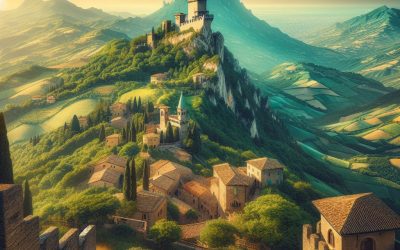
San Marino, one of the world’s oldest republics, is a microstate nestled within the Apennine Mountains of Italy. Established in the year 301 AD, it boasts a rich history that has allowed it to maintain its independence through centuries of political upheaval and territorial disputes in the region. With an area of just 61 square kilometres, San Marino is the fifth smallest country in the world, yet it is steeped in cultural heritage and historical significance. The capital city, also named San Marino, is perched atop Mount Titano, offering breathtaking views of the surrounding landscape. The country’s unique status as a landlocked enclave within Italy has fostered a distinct identity, characterised by its traditions, governance, and a strong sense of national pride. Visitors to San Marino are often captivated by its medieval architecture and picturesque scenery. The country is renowned for its well-preserved historical sites, which reflect its long-standing commitment to preserving its cultural legacy. The population of approximately 34,000 residents enjoys a high standard of living, supported by a robust economy primarily driven by tourism, finance, and manufacturing. As one traverses the cobbled streets of the capital, it becomes evident that San Marino is not merely a tourist destination but a living testament to resilience and continuity. The republic’s commitment to democracy and self-governance is enshrined in its constitution, which has remained largely unchanged since 1600. This enduring political framework has allowed San Marino to thrive as a beacon of stability in an often tumultuous region. Summary San Marino is a small, landlocked country surrounded by Italy, known for its medieval architecture and rich history. The Three Towers...

Climate Zones of San Marino: Different climate regions Of San Marino
San Marino, a small landlocked republic nestled within Italy, boasts a rich tapestry of climate zones that contribute to its unique environmental and cultural landscape. Despite its modest size, the country experiences a variety of climatic conditions, influenced by its geographical location and topography. The interplay between the Apennine Mountains and the Adriatic Sea creates a microclimate that varies significantly across different regions of San Marino. This diversity not only shapes the natural environment but also plays a crucial role in the daily lives of its inhabitants, influencing everything from agriculture to tourism. Understanding the climate zones of San Marino is essential for appreciating the ecological and economic dynamics of this historic enclave. The republic’s climate can be broadly categorised into four distinct zones: the Mediterranean, mountainous, coastal, and transitional climates. Each zone presents its own set of characteristics, including temperature ranges, precipitation patterns, and seasonal variations. This article will delve into each of these climate zones, exploring their unique features and the implications they have for the environment and society in San Marino. Summary San Marino has diverse climate zones, including the Mediterranean, Mountainous, Coastal, and Transitional zones. The Mediterranean climate zone is characterized by hot, dry summers and mild, wet winters, making it suitable for agriculture. The Mountainous climate zone experiences colder temperatures and higher precipitation, making it ideal for alpine vegetation and forestry. The Coastal climate zone has milder temperatures and lower precipitation, creating a suitable environment for vineyards and olive groves. The Transitional climate zone exhibits a mix of characteristics from the other zones, creating a unique environment for a variety of crops and vegetation....

Population Density of San Marino
San Marino, one of the world’s smallest and oldest republics, is nestled within the Apennine Mountains, entirely surrounded by Italy. Established in AD 301, it boasts a rich history that has shaped its unique identity and governance. With a land area of just 61 square kilometres, San Marino is often overshadowed by its larger neighbour, yet it possesses a distinct cultural heritage and political autonomy that make it a fascinating subject of study. The country is renowned for its medieval architecture, including the iconic Guaita, Cesta, and Montale towers that crown Mount Titano, offering breathtaking views of the surrounding landscape. Despite its diminutive size, San Marino has managed to maintain a stable economy, primarily driven by tourism, finance, and manufacturing. The population of San Marino is approximately 34,000, which contributes to its status as one of the least densely populated countries in Europe. However, this figure belies the complexities of population density within such a small territory. The interplay between geography, historical development, and socio-economic factors has resulted in a unique demographic landscape. Understanding the nuances of population density in San Marino is crucial for grasping the challenges and opportunities that arise from living in such a compact nation. As we delve deeper into this topic, we will explore the various factors influencing population density, compare it with other nations, and examine the implications for infrastructure and sustainable development. Summary San Marino is a small landlocked country in southern Europe, surrounded by Italy. It is one of the world’s oldest republics and is known for its medieval architecture and rich cultural heritage. Population density refers to the number of...

History of San Marino
The origins of San Marino are steeped in legend and historical ambiguity, with its founding traditionally attributed to a stonemason named Marinus in the year 301 AD. According to the narrative, Marinus fled from the island of Rab, located in present-day Croatia, to escape religious persecution under the Roman Emperor Diocletian. Upon reaching the mountainous region of Monte Titano, he established a small community that would eventually evolve into the Republic...

Terrain and Topography of San Marino: mountains, valleys, and plains.
San Marino, one of the world’s smallest republics, is nestled within the Apennine mountain range in central Italy. This landlocked microstate, covering an area of just 61 square kilometres, boasts a diverse and captivating terrain that has shaped its history, culture, and economy. The topography of San Marino is characterised by a series of rolling hills, steep cliffs, and picturesque valleys, all of which contribute to its unique charm. The republic’s elevation ranges from approximately 55 metres to 739 metres above sea level, with Mount Titano being the highest point. This varied landscape not only provides stunning vistas but also plays a crucial role in the daily lives of its inhabitants. The geographical features of San Marino are not merely aesthetic; they have influenced the development of settlements, agriculture, and transportation throughout the centuries. The rugged terrain has historically served as a natural fortress, offering protection from invasions and fostering a sense of independence among its citizens. As a result, the topography has become intertwined with the national identity of San Marino, making it a symbol of resilience and autonomy. Understanding the intricate relationship between the terrain and the people who inhabit it is essential for appreciating the rich tapestry of San Marino’s history and culture. Summary San Marino’s terrain is characterized by mountainous landscapes, valleys, and plains. The mountainous landscape of San Marino offers stunning panoramic views and is a popular tourist attraction. The valleys of San Marino are fertile and support agricultural activities such as vineyards and olive groves. The plains of San Marino are limited in size but are important for urban development and infrastructure. The...
San Marino
San Marino (Repubblica di San Marino (Republic of San Marino)) Capital: San Marino Population (Estimated July 2012): 32,140 Area: 61.2km2 or 23.63mi2 Currency: Euro (€) Official Language: Italian Political Information: Parliamentary Republic Official Religion: No Official Religion(predominately Roman Catholic) Highest Mountain: Monte Titano at 755m or 2,477ft GDP Official Exchange Rate (OER is more precise at gauging a country’s economic power) (Estimated 2011): $1.611 billion (US$) or (GBP) GDP (OER) Per Capita (per member of the population estimated 2011): (US$) or (GBP) GDP Purchasing Power Parity (PPP is good for gauging living conditions and the use of resources but is not as accurate as OER. This data has been calculated based on the sum value of all goods and services produced in the country valued at prices prevailing in the United States) (Estimated 2011): $1.136 billion (US$) or (GBP) GDP (PPP) Per Capita (per member of the population estimated 2009): $36,200 (US$) or (GBP) Time Zone (GMT/UTC): +1:00 Wildlife: Counties/Provinces/States: 9 municipalities (castelli, singular – castello); Acquaviva, Borgo Maggiore, Chiesanuova, Domagnano, Faetano, Fiorentino, Montegiardino, San Marino Citta, Serravalle Leaders: Co-chiefs of State Captain Regent Maurizio Rattini and Captain Regent Italo Righi with Secretary of State for Foreign and Political Affairs Antonella Mularoni. Sources: CIA World Fact Book, Encyclopaedia Britannica. San Marino: Europe’s Oldest Republic San Marino, a microstate nestled within the Italian peninsula, is one of the world’s smallest and oldest republics. Covering an area of just 61 square kilometres, it is entirely surrounded by Italy, yet it boasts a rich history and a unique identity that sets it apart from its larger neighbour. Established in the early 4th century, San Marino is...

Terrain and Topography of Samoa: mountains, valleys, and plains.
Samoa, an enchanting archipelago located in the heart of the South Pacific, is renowned for its stunning natural landscapes and diverse topography. Comprising two main islands, Upolu and Savai’i, along with several smaller islets, Samoa‘s terrain is characterised by a rich tapestry of volcanic mountains, lush valleys, and pristine coastal areas. The islands were formed through volcanic activity, which has left a lasting imprint on their geography. This geological history has resulted in a unique combination of features that not only shape the physical environment but also influence the cultural and social dynamics of the Samoan people. The interplay between land and sea creates a vibrant ecosystem that supports a variety of flora and fauna, making Samoa a true paradise for nature lovers and adventurers alike. The topography of Samoa is not merely a backdrop; it plays a crucial role in the daily lives of its inhabitants. The rugged mountains and fertile valleys provide resources essential for sustenance, while the coastal plains offer access to the bountiful ocean. This intricate relationship between the land and its people has fostered a deep respect for nature within Samoan culture. Traditional practices, such as fishing and agriculture, are closely tied to the rhythms of the environment, reflecting a profound understanding of the land’s capabilities and limitations. As we delve deeper into the various aspects of Samoa’s terrain, we will uncover how these geographical features have shaped not only the physical landscape but also the cultural identity of this remarkable nation. Summary Samoa’s terrain is characterized by rugged mountain ranges, lush valleys and gorges, and picturesque coastal plains. The mountain ranges of Samoa,...

Political Boundaries of Samoa: Provinces, Districts, or Historical Boundaries.
Samoa, an archipelago located in the South Pacific Ocean, is renowned for its stunning natural beauty and rich cultural heritage. However, beneath its picturesque landscapes lies a complex political structure that has evolved over centuries. The political boundaries of Samoa are not merely lines on a map; they represent the historical, social, and cultural dynamics that have shaped the nation. These boundaries delineate the various provinces and districts, each with its own unique identity and governance structures. Understanding Samoa’s political boundaries is essential for grasping the intricacies of its governance and the challenges it faces in contemporary times. The political landscape of Samoa is characterised by a blend of traditional and modern governance systems. The country is divided into two main islands, Upolu and Savai’i, along with several smaller islands, each contributing to the overall political framework. The boundaries established within this framework are influenced by historical events, colonial legacies, and the aspirations of the Samoan people. As Samoa continues to navigate its path in a globalised world, the significance of these political boundaries becomes increasingly apparent, impacting everything from local governance to national identity. Summary Samoa’s political boundaries are defined by its geographical location in the South Pacific Ocean and its historical ties to colonial powers. Samoa is divided into 11 provinces, each with its own unique cultural and social identity. Within the provinces, there are 51 districts that play a crucial role in local governance and administration. The historical boundaries of Samoa have been shaped by colonial influences and the country’s struggle for independence. The impact of political boundaries on governance in Samoa is evident in the...

Climate Zones of Samoa: Different climate regions Of Samoa
Samoa, an archipelago located in the heart of the South Pacific, is renowned for its stunning natural beauty and rich cultural heritage. The islands are characterised by a diverse range of climate zones, each contributing uniquely to the ecological and cultural tapestry of the region. The climate of Samoa is predominantly tropical, influenced by its geographical position and the surrounding oceanic currents. This tropical climate is further divided into several distinct zones, including tropical rainforest, tropical savanna, tropical monsoon, subtropical, marine, and highland climates. Each of these zones plays a crucial role in shaping the environment, biodiversity, and lifestyle of the Samoan people. Understanding Samoa’s climate zones is essential for appreciating the intricate relationship between the environment and the local culture. The islands experience a warm and humid climate, with temperatures typically ranging from 24°C to 30°C throughout the year. Rainfall patterns vary significantly across the different climate zones, influencing agricultural practices, water resources, and even traditional customs. The interplay between these climatic conditions and the natural landscape has fostered a unique way of life for the Samoan people, who have adapted their practices to thrive in this vibrant yet challenging environment. As we delve deeper into each climate zone, we will uncover how these factors contribute to the overall character of Samoa. Summary Samoa has a diverse range of climate zones, each with its own unique characteristics and impact on the environment and culture. The Tropical Rainforest Climate Zone in Samoa is characterized by high temperatures, heavy rainfall, and lush vegetation, supporting a wide variety of plant and animal species. The Tropical Savanna Climate Zone experiences distinct wet...

History of Samoa
The early settlement of Samoa is a fascinating chapter in the history of the Pacific Islands, marked by the arrival of Polynesian navigators who traversed vast oceanic distances. Archaeological evidence suggests that these early settlers arrived in Samoa around 1000 BCE, bringing with them a rich tapestry of culture, language, and agricultural practices. They established a society that was intricately connected to the land and sea, relying on fishing, farming, and the cultivation of taro and coconut palms. The Samoan way of life was deeply rooted in communal living, with extended families forming the backbone of their social structure. This early society developed a complex system of governance, with chiefs known as ‘matai’ leading their communities and maintaining order through a blend of tradition and consensus. As these early settlers adapted to their new environment, they also developed a unique cultural identity that would endure for centuries. The Samoan language, which belongs to the Austronesian family, became a vital means of communication and cultural expression. Oral traditions flourished, with stories, songs, and dances passed down through generations, preserving the history and values of the Samoan people. The concept of ‘fa’a Samoa’, or the Samoan way, emerged as a guiding principle for social conduct and community life. This cultural framework emphasised respect for elders, communal responsibility, and a deep connection to the land. The early settlement period laid the foundation for a resilient society that would face numerous challenges in the centuries to come. Summary Early settlement of Samoa dates back to around 1000 BCE, with evidence of Polynesian settlers arriving in the region. Contact with European explorers began in...