Explore the World Through Geography, Natural Resources & Daily History
Clear, reliable and engaging guides that help you understand our planet — from UK geography education to global natural resources and On This Day history events.
Explore, discover, and learn about the wonders of our world! At Earth Site, we’re passionate about bringing geography, history, and science to life for curious minds of all ages. Whether you’re delving into historical events, uncovering the mysteries of the natural world, or seeking interactive resources, you’re in the right place.
Here, you can uncover the stories behind historical events, explore the natural wonders of our planet, and gain valuable insights into how the Earth’s systems shape our daily lives. From the towering peaks of mountain ranges to the far-reaching impacts of human innovation, we aim to make every topic both engaging and informative.
Start your journey of discovery with us today, and let’s make learning an adventure!
What We Cover
Earth Site brings together engaging and accessible educational content designed to help you understand the world, its history, and its natural systems.
🌍 Geography Education (UK & Worldwide)
We publish clear, easy-to-understand geography resources for students, teachers and curious learners. Our guides support geography education in the UK and cover physical geography, climate, ecosystems, population, and global development.
⛏️ Natural Resources & Environmental Geography
Explore detailed country profiles covering natural resources, mining, energy, geology and global environmental challenges. We show how nations manage minerals, water, land and ecosystems, and why these resources matter.
📅 On This Day in History
Every day has a story. Our On This Day history series features major events, anniversaries, traditions, and cultural milestones from around the world — with timelines, context, and fun facts.
TIMELINE

History of Monaco
Monaco’s history extends to ancient times, with archaeological evidence indicating human settlement dating to the Palaeolithic era. The region’s strategic Mediterranean coastal location made it attractive to early settlers, and various tribes and civilisations inhabited the area over centuries. The arrival of the Romans, however, had a lasting impact on Monaco‘s history. The Romans established a presence in the region in the 6th century BC, and Monaco became a significant outpost for the Roman Empire. They constructed a fortress on the Rock of Monaco, providing a strategic vantage point for coastal monitoring and defence. Roman influence remains visible in Monaco today, with remnants of Roman architecture and infrastructure scattered throughout the principality. The Roman influence on Monaco extended beyond military and strategic considerations. They introduced new agricultural techniques and crops to the region, stimulating economic growth and development. The Roman presence also brought about cultural and social changes, as Monaco became a melting pot of diverse influences and traditions. The legacy of the Roman era persists in Monaco’s language, customs, and traditions, forming an integral part of the principality’s identity. The Roman influence on Monaco was profound and far-reaching, shaping the region’s development and laying the groundwork for its future as a significant player in European history. Summary Early settlement in Monaco dates back to the ancient Romans, who left a lasting influence on the region’s culture and architecture. The House of Grimaldi played a pivotal role in the founding and establishment of Monaco as an independent principality. Monaco’s strategic location made it a key player in European politics and warfare throughout history. The Treaty of Perpetual Peace solidified...

Natural Resources of Monaco: Where Natural Resources are Located in Monaco
Monaco, a diminutive sovereign city-state situated on the French Riviera in Western Europe, is renowned for its opulent lifestyle, upmarket casinos and prestigious yacht-filled harbour. Despite its modest size, Monaco possesses a variety of natural resources that contribute to its distinctive environment and economy. From its water resources to its terrestrial and marine assets, Monaco’s natural endowments play a crucial role in shaping the principality’s identity and sustainability. This article shall examine the diverse natural resources of Monaco and the endeavours undertaken towards their sustainable management. Summary Monaco is a small country with limited natural resources, making sustainable management crucial. The country relies heavily on imported water due to its lack of freshwater sources. Land resources in Monaco are scarce, leading to careful urban planning and land use management. Monaco is committed to renewable energy sources and has invested in solar and wind power. The country’s marine resources are important for its economy, with a focus on sustainable fishing practices. Monaco’s Water Resources Advanced Desalination Technology The Principality has invested in advanced desalination technology to ensure a reliable source of clean drinking water for its residents and visitors. Furthermore, Monaco has implemented strict regulations to protect its water quality and marine ecosystems, including the establishment of marine protected areas and the monitoring of pollution levels. These measures are essential for preserving the integrity of Monaco’s water resources and ensuring their sustainable use for future generations. Water Conservation and Efficiency Monaco’s commitment to sustainable water management is evident in its efforts to promote water conservation and efficiency. The country has implemented water-saving initiatives such as the use of recycled water...

Cultural or Historical Sites of Monaco: Important Cultural Landmarks or Historical Sites in Monaco
The Prince’s Palace of Monaco, also known as the Palais Princier, is a historic residence situated in the centre of Monaco. This grand palace has served as the official residence of the Prince of Monaco since the 13th century and boasts a rich history dating back to mediaeval times. The palace exemplifies Renaissance architecture and stands as a symbol of the principality’s heritage and royal lineage. The Prince’s Palace serves not only as a residence but also as an emblem of the principality’s sovereignty and independence. The palace is accessible to the public, allowing visitors to explore its luxurious state rooms, expansive courtyards, and well-maintained gardens. The changing of the guard ceremony, which occurs daily at 11:55, is a popular attraction for tourists and provides insight into the principality’s royal traditions. The palace also houses a significant collection of historical artefacts, including paintings, tapestries, and period furniture, offering visitors a glimpse into Monaco’s royal history and cultural heritage. Summary The Prince’s Palace of Monaco is a historic residence with stunning architecture and a rich royal history. The Oceanographic Museum is a hub of marine science and history, showcasing a diverse collection of marine life and artifacts. The Monte Carlo Casino is a symbol of luxury and glamour, attracting visitors from around the world with its opulent decor and high-stakes gambling. The Monaco Cathedral is a religious and architectural marvel, featuring beautiful Roman-Byzantine design and the final resting place of Princess Grace. The Jardin Exotique de Monaco is a botanical gem, home to a diverse collection of exotic plants and stunning panoramic views of the Mediterranean. The Monaco Top Cars...

Population Density of Monaco
Monaco, a diminutive sovereign city-state situated on the French Riviera in Western Europe, is renowned for its exceptionally high population density. Encompassing a mere 2.02 square kilometres, Monaco ranks as the world’s second smallest country, surpassed only by Vatican City. Despite its limited geographical expanse, Monaco boasts a population exceeding 38,000 inhabitants, rendering it one of the most densely populated nations globally. The population density of Monaco is estimated at approximately 18,713 persons per square kilometre, a figure markedly higher than that of most other countries. This pronounced population density presents both opportunities and challenges for Monaco’s residents and government. The elevated population density in Monaco stems from various factors, including its prime location, economic prospects, and distinctive tax regime. The principality’s strategic position on the Mediterranean coast, coupled with its agreeable climate and reputation as a haven for the affluent, has rendered it an attractive destination for tourists and expatriates alike. Furthermore, Monaco’s status as a tax haven, notably its absence of income tax, has drawn wealthy individuals and businesses from across the globe. These elements have contributed significantly to the rapid expansion of Monaco’s population and the resultant high population density. Summary Monaco has the highest population density in the world, with over 25,000 people per square kilometre. Factors contributing to Monaco’s high population density include limited land area, high standard of living, and attractive tax policies. Challenges of high population density in Monaco include traffic congestion, limited housing space, and pressure on public services. Urban planning and infrastructure in Monaco focus on vertical expansion, efficient public transport, and sustainable development. Compared to other countries, Monaco’s population...
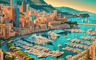
Monaco
Monaco (Principauté de Monaco (Principality of Monaco)) Capital: Monaco Population (Estimated July 2012): 30,510 Area: 2.02km2 or 0.78mi2 Currency: Euro (€) Official Language: French Political Information: Principality with Constitutional Monarchy Official Religion: Roman Catholicism (with approximately 90% of the population Roman Catholic and 10% following other faiths) Highest Mountain: No mountain peak but part of Monaco is situated on the side of Mont Angel. GDP Official Exchange Rate (OER is more precise at gauging a country’s economic power) (Estimated 2010): $5.47 billion (US$) or (GBP) GDP (OER) Per Capita (per member of the population estimated 2009): $63,400 (US$) or (GBP) GDP Purchasing Power Parity (PPP is good for gauging living conditions and the use of resources but is not as accurate as OER. This data has been calculated based on the sum value of all goods and services produced in the country valued at prices prevailing in the United States) (Estimated 2010): $5.47 billion (US$) or (GBP) Time Zone (GMT/UTC): +1:00 Wildlife: Counties/Provinces/States: 4 quarters (quartiers, singular – quartier); Fontvieille, La Condamine, Monaco-Ville, Monte-Carlo Leaders: Prince Albert II with Minister of State Michel Roger (assisted by the Council of Government) Sources: CIA World Fact Book, Encyclopaedia Britannica. Monaco Monaco, officially known as the Principality of Monaco, is a sovereign city-state and microstate situated on the French Riviera in Western Europe. It is bordered by France on three sides, with the Mediterranean Sea forming its fourth boundary. With an area of just over 2 square kilometres, Monaco is the second smallest country in the world, after Vatican City. Despite its diminutive size, Monaco is renowned for its opulence, luxury, and glamour, rendering it a popular destination for the wealthy and famous. The official...

Political Boundaries of Moldova: Provinces, Districts, or Historical Boundaries.
Moldova, a small landlocked country in Eastern Europe, shares borders with Romania to the west and Ukraine to the north, east and south. The political boundaries of Moldova are delineated by its administrative divisions, which comprise regions and districts. These boundaries are fundamental to the country’s governance and administration, determining resource allocation, representation and decision-making processes. A thorough understanding of Moldova’s political boundaries is crucial for comprehending the nation’s historical, cultural and political dynamics. The political boundaries of Moldova have undergone changes over time, influenced by historical, geographical and geopolitical factors. The regions and districts of Moldova are essential components of the country’s governance structure, providing a framework for local administration and representation. As Moldova continues to develop as an independent nation, its political boundaries play a significant role in shaping the country’s future direction. Summary Moldova’s political boundaries are defined by its borders with Ukraine and Romania, as well as the breakaway region of Transnistria. Moldova is divided into 32 districts, each with its own administrative centre and local government. The historical boundaries of Moldova have fluctuated over time, with periods of expansion and contraction. A comparison of provinces, districts, and historical boundaries reveals the complex and dynamic nature of Moldova’s political landscape. The impact of political boundaries on Moldova’s governance is significant, influencing issues such as regional development and decentralisation. The future of Moldova’s political boundaries is uncertain, with ongoing debates about potential changes to the country’s administrative divisions. Provinces of Moldova Administrative Structure The remainder of Moldova is divided into nine counties, each with its own administrative centre and local government. Role of Provinces in Governance...

Climate Zones Of Moldova: Different climate regions Of Moldova
Moldova, a small landlocked country in Eastern Europe, is characterised by diverse climate zones. Situated between the 45th and 48th parallels north, the country lies within the temperate climate zone. Moldova‘s climate is influenced by its proximity to the Black Sea, the Carpathian Mountains, and the continental landmass of Eastern Europe. Consequently, the country experiences a range of climatic conditions, from continental to subtropical. These varied climate zones significantly impact the nation’s agriculture, natural resources, and overall way of life. Moldova can be divided into five primary climate zones: the continental climate of central Moldova, the moderately continental climate of southern Moldova, the subtropical climate of the Black Sea coast, the alpine climate of the Carpathian Mountains, and the transitional climate zone between the Carpathian Mountains and the rest of the country. Each of these climate zones possesses distinct characteristics and influences on the local environment. A thorough understanding of these climate zones is essential for comprehending the country’s agricultural practices, natural resources, and environmental challenges. Summary Moldova has a diverse range of climate zones, including continental, moderately continental, subtropical, and alpine. Central Moldova experiences a continental climate with hot summers and cold winters, making it suitable for growing wheat and sunflower crops. Southern Moldova has a moderately continental climate with milder winters and warmer summers, ideal for vineyards and fruit orchards. The Black Sea coast of Moldova has a subtropical climate, with mild winters and hot summers, creating a favourable environment for tourism and agriculture. The Carpathian Mountains in Moldova have an alpine climate, with cold temperatures and heavy snowfall, impacting the region’s natural resources and wildlife. The...

Terrain and Topography of Moldova: mountains, valleys, and plains.
Moldova, a small landlocked country in Eastern Europe, is renowned for its diverse and varied terrain. The nation’s topography is characterised by a mixture of mountains, valleys, hills and plains, rendering it a unique and intriguing destination for nature enthusiasts. Moldova‘s terrain has been shaped by geological processes over millions of years, resulting in a landscape that is both picturesque and diverse. From the rugged Carpathian Mountains in the north to the flat Bugeac Plain in the south, Moldova’s terrain offers a wide range of natural features that merit exploration. Moldova’s terrain is not only visually striking but also plays a crucial role in shaping the country’s climate, flora and fauna. The diverse topography of the nation has created a variety of ecosystems, each with its own unique characteristics and biodiversity. From dense forests to fertile river valleys, Moldova’s terrain provides a habitat for a wide range of plant and animal species. Understanding the country’s topography is essential for appreciating its natural beauty and comprehending the challenges and opportunities it presents for the people who call it home. Summary Moldova’s terrain is diverse, with mountains, river valleys, hills, and plains. The Carpathian Mountains form Moldova’s northern border, providing a rugged and picturesque landscape. The Nistru River Valley cuts through the central lowland of Moldova, offering fertile land for agriculture. The Prut River Valley in the southern lowland is another important agricultural region in Moldova. The Codri Hills in the western part of Moldova offer a scenic and hilly landscape, rich in biodiversity. The Bugeac Plain in the southernmost region of Moldova is characterized by flat and open terrain, suitable...

History of Moldova
Moldova’s history extends to ancient times, with archaeological evidence of human habitation in the region dating to the Palaeolithic era. Various tribes and peoples, including the Thracians, Dacians and Celts, inhabited the area. In the 4th century BC, the region came under Roman Empire control and was known as Dacia. The Romans constructed fortresses and roads in the area, leaving an enduring impact on the region’s culture and infrastructure. Following the Roman Empire’s decline, Moldova experienced invasions and settlements by various peoples, including the Huns, Goths and Slavs. In the 14th century, the principality of Moldavia emerged as a formidable state under Prince Dragos’s rule. The principality expanded its territory and became a significant regional power, engaging in trade and diplomacy with neighbouring states. The capital city of Suceava developed into a centre of culture and learning, attracting scholars and artists from across Europe. Summary Early settlements in Moldova date back to ancient times, with evidence of human habitation from as early as the Paleolithic era. Ottoman and Russian rule significantly shaped Moldova’s history, with the region being part of the Ottoman Empire and later falling under Russian control. Moldova declared independence from the Soviet Union in 1991, marking the beginning of a new era for the country. The Transnistrian conflict, which began in 1990, continues to be a major issue in Moldova, with the breakaway region seeking independence from the rest of the country. Moldova has faced challenges in recent years, including political instability and economic struggles, but has also made efforts to strengthen ties with the European Union and improve its economy. Ottoman and Russian Rule The...

Natural Resources of Moldova: Where Natural Resources are Located in Moldova
Moldova, a small landlocked country in Eastern Europe, possesses a variety of natural resources that contribute to its economy and the well-being of its citizens. From fertile agricultural land to mineral deposits and abundant water resources, Moldova‘s natural wealth plays a crucial role in the country’s development. The diverse range of natural resources in Moldova has also made it an attractive destination for investment and trade, further bolstering its economic growth. This article will explore the different natural resources that Moldova possesses, their significance, and the efforts made towards their conservation and sustainable use. Moldova’s natural resources have been a cornerstone of its economy for centuries, with agriculture being a major contributor to the country’s GDP. The fertile soil and favourable climate in Moldova make it ideal for the cultivation of a variety of crops, including grapes, fruits, vegetables, and grains. The agricultural sector not only provides food security for the population but also contributes significantly to the country’s exports, earning valuable foreign exchange. In addition to agriculture, Moldova is also rich in mineral resources such as limestone, gypsum, and clay, which are essential for the construction and manufacturing industries. The abundance of water resources, including rivers and lakes, further enhances the country’s potential for agricultural and industrial development. With its diverse natural resources, Moldova has the foundation for sustainable economic growth and development. Summary Moldova is rich in natural resources, including agricultural, mineral, water, forest, and energy resources. The agricultural sector in Moldova is a significant contributor to the country’s economy, with a focus on wine production, fruits, and vegetables. Moldova has mineral resources such as limestone, gypsum,...

Cultural or Historical Sites of Moldova: Important Cultural Landmarks or Historical Sites in Moldova
Moldova, a small landlocked country in Eastern Europe, possesses a wealth of cultural and historical sites that reflect its diverse and intriguing history. From ancient archaeological complexes to mediaeval fortresses and monasteries, Moldova‘s cultural and historical sites provide insight into the country’s past and its vibrant cultural heritage. The nation’s strategic location at the crossroads of various civilisations has left an enduring mark on its architecture, art and traditions. Visitors to Moldova can explore a wide range of cultural and historical sites that showcase the country’s unique identity and rich heritage. Moldova’s cultural and historical sites stand as a testament to the country’s resilience and enduring spirit. Despite facing numerous challenges throughout its history, Moldova has preserved its cultural treasures and continues to celebrate its heritage through these remarkable sites. Whether it is the ancient archaeological complex of Orheiul Vechi, the imposing Soroca Fortress, or the serene Capriana Monastery, each site offers a window into Moldova’s past and its enduring legacy. As visitors explore these sites, they can gain a deeper understanding of Moldova’s history, traditions and the influences that have shaped the country over the centuries. Summary Moldova is home to a rich cultural and historical heritage, with a variety of sites to explore. The Orheiul Vechi Archaeological Complex offers a glimpse into Moldova’s ancient past with its cave monastery and archaeological remains. The Soroca Fortress is a well-preserved example of medieval defensive architecture, offering visitors a chance to step back in time. The Capriana Monastery is a peaceful and picturesque site, with a history dating back to the 15th century. The National Museum of History of Moldova...

Population Density of Moldova
Moldova, a small landlocked country in Eastern Europe, is characterised by its high population density. With a population exceeding 4 million inhabitants and a land area of 33,846 square kilometres, Moldova possesses one of the highest population densities in Europe. This concentration of people within a relatively compact area presents various social, economic and environmental challenges. It is crucial to comprehend the factors contributing to this high population density, its impact on infrastructure and resources, and the efforts to manage and mitigate its effects for the sustainable development of the country. The population density of Moldova is a consequence of various historical, social and economic factors that have shaped the country’s demographic landscape. The impact of this high population density is evident in the strain it places on infrastructure and resources, as well as the challenges it poses for sustainable development. Efforts to manage and mitigate the effects of high population density in Moldova are essential for the country’s future growth and prosperity. Looking ahead, projections for Moldova’s population density indicate the need for strategic planning and policy interventions to address the challenges associated with high population density. Summary Moldova has one of the highest population densities in Europe, with over 1200 people per square mile. Factors contributing to Moldova’s high population density include high birth rates, limited emigration, and a small land area. The high population density in Moldova puts a strain on infrastructure and resources, leading to challenges in housing, transportation, and access to clean water. Compared to other European countries, Moldova’s population density is significantly higher, with only a few countries like the Netherlands and Belgium...