Explore the World Through Geography, Natural Resources & Daily History
Clear, reliable and engaging guides that help you understand our planet — from UK geography education to global natural resources and On This Day history events.
Explore, discover, and learn about the wonders of our world! At Earth Site, we’re passionate about bringing geography, history, and science to life for curious minds of all ages. Whether you’re delving into historical events, uncovering the mysteries of the natural world, or seeking interactive resources, you’re in the right place.
Here, you can uncover the stories behind historical events, explore the natural wonders of our planet, and gain valuable insights into how the Earth’s systems shape our daily lives. From the towering peaks of mountain ranges to the far-reaching impacts of human innovation, we aim to make every topic both engaging and informative.
Start your journey of discovery with us today, and let’s make learning an adventure!
What We Cover
Earth Site brings together engaging and accessible educational content designed to help you understand the world, its history, and its natural systems.
🌍 Geography Education (UK & Worldwide)
We publish clear, easy-to-understand geography resources for students, teachers and curious learners. Our guides support geography education in the UK and cover physical geography, climate, ecosystems, population, and global development.
⛏️ Natural Resources & Environmental Geography
Explore detailed country profiles covering natural resources, mining, energy, geology and global environmental challenges. We show how nations manage minerals, water, land and ecosystems, and why these resources matter.
📅 On This Day in History
Every day has a story. Our On This Day history series features major events, anniversaries, traditions, and cultural milestones from around the world — with timelines, context, and fun facts.
TIMELINE

Climate Zones Of Mexico: Different Climate Regions Of Mexico
Mexico is a nation renowned for its varied climate zones, spanning from tropical to alpine. This diversity is primarily attributable to Mexico‘s geographical position, which extends from the Tropic of Cancer in the south to the temperate regions in the north. The nation’s climate is further influenced by its topography, with mountain ranges, plateaux, and coastal plains all contributing to the variation in weather patterns. Comprehending Mexico’s climate zones is crucial for anyone intending to visit or reside in the country, as it can significantly impact activities, clothing choices, and overall lifestyle. Summary Mexico has a diverse range of climate zones, including tropical, arid, semi-arid, temperate, alpine, and coastal regions. The tropical climate regions of Mexico are characterized by high temperatures and heavy rainfall, with distinct wet and dry seasons. Arid and semi-arid climate regions cover a large portion of Mexico, with low precipitation and high temperatures, creating desert landscapes. The temperate climate regions of Mexico experience mild temperatures and moderate rainfall, making them suitable for agriculture and diverse ecosystems. Alpine climate regions are found in the mountainous areas of Mexico, with cold temperatures and snowfall, supporting unique flora and fauna. Tropical Climate Regions of Mexico Seasonal Variations The wet season typically runs from May to October, bringing heavy rainfall and the potential for tropical storms and hurricanes. The dry season, from November to April, offers more moderate temperatures and less precipitation. Natural Wonders and Eco-Tourism The lush vegetation and diverse wildlife in these regions thrive in the tropical climate, making them popular destinations for eco-tourism and nature enthusiasts. The beaches of Cancun, the jungles of Chiapas, and the...

Terrain and Topography of Mexico: mountains, valleys, and plains.
Mexico is a country with diverse terrain and topography. From rugged mountains to vast plains, Mexico‘s landscape is remarkable. The country is situated in the southern portion of North America, bordered by the United States to the north, the Pacific Ocean to the west, Guatemala and Belize to the southeast, and the Gulf of Mexico to the east. The terrain and topography of Mexico have significantly influenced the country’s climate, ecosystems, history and culture. With its rich and varied landscape, Mexico offers a wide range of natural beauty and outdoor pursuits for residents and visitors alike. The terrain of Mexico is characterised by its diverse topography, which includes mountains, valleys, plains and coastal areas. The country is home to several mountain ranges, including the Sierra Madre Occidental in the west, the Sierra Madre Oriental in the east, and the Sierra Madre del Sur in the south. These mountain ranges are known for their rugged terrain and stunning landscapes, making them popular destinations for hiking, mountaineering and other outdoor activities. In addition to its mountains, Mexico also boasts picturesque valleys, such as the Bajio Valley and the Valley of Mexico, which are known for their fertile soil and agricultural productivity. The country’s vast plains, including the Yucatan Peninsula and the Mexican Plateau, are also notable for their expansive landscapes and unique ecosystems. With its diverse terrain and topography, Mexico offers a wide range of natural beauty and outdoor activities for residents and visitors alike. Summary Mexico’s terrain and topography are incredibly diverse, ranging from mountains and valleys to vast plains. The majestic mountains of Mexico, including the Sierra Madre and...

History of Mexico
Mexico possesses a rich and diverse history spanning thousands of years. Prior to the arrival of Spanish conquistadors, the region was home to several advanced civilisations, including the Olmec, Maya, and Aztec. The Olmec, considered the first major civilisation in Mexico, flourished from approximately 1400 to 400 BCE in the southern part of the country. They are renowned for their colossal stone heads and intricate carvings, which are regarded as some of the earliest examples of Mesoamerican art. The Maya civilisation, which reached its zenith between 250 and 900 CE, was noted for its advanced knowledge of astronomy, mathematics, and architecture. The Maya constructed impressive cities with elaborate stone temples and palaces, and developed a complex writing system that scholars continue to decipher today. The Aztec civilisation, which emerged in the 14th century, was known for its powerful empire and sophisticated social structure. The Aztecs built their capital city of Tenochtitlan on an island in Lake Texcoco, which is now the site of modern-day Mexico City. They were also skilled engineers and farmers, creating intricate irrigation systems and cultivating crops such as maize, beans, and squash. These ancient civilisations left an enduring impact on Mexican culture, and their achievements continue to be celebrated and studied to this day. From their impressive architectural feats to their advancements in science and art, the Olmec, Maya, and Aztec civilisations laid the foundation for the rich cultural heritage of modern Mexico. Summary The Olmec, Maya, and Aztec civilizations were the pre-Columbian cultures that laid the foundation for Mexican society. Hernán Cortés led the Spanish conquest and established New Spain, leading to centuries of...

Population Density of Mexico
Mexico is a country situated in the southern portion of North America, boasting a population exceeding 126 million inhabitants, rendering it the 11th most populous nation globally. The population density of Mexico stands at approximately 66 individuals per square kilometre, with the majority of residents concentrated in urban areas. Population density varies significantly across the country, with the highest concentrations observed in the central and southern regions, particularly in and around the capital city, Mexico City. The population density in Mexico has been steadily increasing over time, driven by factors such as natural population growth, rural-to-urban migration, and immigration from other countries. This demographic shift has presented both challenges and opportunities for the nation. Mexico’s population density is influenced by a variety of factors, including geography, climate, economic opportunities, and governmental policies. The country’s diverse topography, encompassing mountains, deserts, and coastal plains, significantly impacts population distribution. The central and southern regions of Mexico, characterised by more temperate and fertile conditions, exhibit higher population densities compared to the arid northern regions. Furthermore, economic opportunities in urban areas, particularly in industries such as manufacturing, services, and tourism, have attracted individuals from rural areas to migrate to cities in search of improved livelihoods. Governmental policies, including land reform and infrastructure development, have also played a role in shaping population density patterns in Mexico. These factors have contributed to the uneven distribution of population across the country, resulting in densely populated urban areas and sparsely populated rural regions. Summary Mexico has a high population density, with over 126 million people living in a relatively small area. Factors influencing population density in Mexico include...

Natural Resources of Mexico: Where Natural Resources are Located in Mexico
Mexico is a country rich in natural resources, with a diverse range of assets that contribute to its economic development and global significance. From oil and gas reserves to abundant renewable energy sources, Mexico‘s natural resources play a crucial role in shaping the country’s economy and providing opportunities for growth and sustainability. The country’s geographical location and topography have also contributed to the richness of its mining industry, whilst its agricultural and forestry sectors benefit from a favourable climate and fertile land. Additionally, Mexico’s water resources are of vital importance, supporting various industries and ecosystems across the country. As Mexico continues to develop and expand its economy, the conservation and sustainable use of its natural resources are becoming increasingly important to ensure the long-term well-being of the country and its people. Mexico’s natural resources are a source of pride and opportunity for the country, providing a solid foundation for economic growth and development. With a diverse range of assets, including oil and gas reserves, mining resources, renewable energy sources, agricultural and forestry products, and abundant water resources, Mexico is well-positioned to meet the needs of its growing population and contribute to global markets. However, the responsible management and conservation of these resources are essential to ensure their long-term sustainability and the well-being of future generations. As Mexico continues to navigate the challenges of economic development and environmental conservation, the country’s natural resources will play a crucial role in shaping its future and contributing to global efforts towards sustainability and environmental stewardship. Summary Mexico is rich in natural resources, including oil and gas reserves, mining industry, agriculture and forestry, renewable...

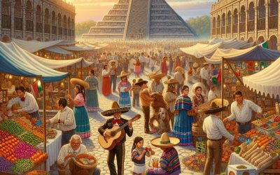
Cultural or Historical Sites of Mexico: Important Cultural Landmarks or Historical Sites in Mexico
Mexico boasts a wealth of cultural and historical heritage, featuring a diverse array of sites that showcase its captivating past. From ancient ruins to colonial architecture, Mexico‘s cultural and historical landmarks provide insight into the country’s vibrant history and the legacy of its indigenous peoples. These sites hold significance not only for their historical importance but also for their cultural and architectural value, drawing visitors from across the globe who are keen to explore Mexico’s rich heritage. The cultural and historical sites of Mexico stand as a testament to the country’s rich and diverse history, spanning millennia. From the ancient civilisations of the Maya and Aztec to the colonial period under Spanish rule, Mexico’s cultural and historical sites offer a unique opportunity to explore the nation’s past and gain a deeper understanding of its cultural identity. Whether one examines the impressive ruins of ancient cities or the grand colonial architecture of its historic centres, Mexico’s cultural and historical sites present a treasure trove of history and culture awaiting discovery. Summary Mexico is home to a rich cultural and historical heritage, with numerous sites that showcase its diverse past. The ancient Mayan ruins of Chichen Itza are a must-visit, offering a glimpse into the fascinating Mayan civilization. Mexico City’s historic centre is renowned for its colonial architecture, providing a window into the country’s colonial past. The pre-Hispanic city of Teotihuacan is a UNESCO World Heritage site, known for its impressive pyramids and ancient urban planning. The archaeological site of Palenque in Chiapas is a treasure trove of Mayan architecture and art, offering a unique insight into the ancient civilization. The...
Mexico
Mexico (Estados Unidos Mexicanos (United Mexican States)) Capital: Mexico City Population (Estimated July 2012): 114,975,406 Area: 1,964,375km2 or 758,450mi2 Currency: Mexican Peso (Mex$) Official Language: Spanish Political Information: Presidential Constitutional Republic Official Religion: No Official Religion (approximately 76.5% of the population are Roman Catholic, 5.2% are Protestant, 1.1% is Jehovah’s Witness, 0.3% follow other faiths, 13.8% have unspecified beliefs and 3.1% have no religious beliefs ) Highest Mountain: Pico de Orizaba at 5,636m or 18,491ft GDP Official Exchange Rate (OER is more precise at gauging a country’s economic power) (Estimated 2011): $1.185 trillion (US$) or (GBP) GDP (OER) Per Capita (per member of the population estimated 2011): (US$) or (GBP) GDP Purchasing Power Parity (PPP is good for gauging living conditions and the use of resources but is not as accurate as OER. This data has been calculated based on the sum value of all goods and services produced in the country valued at prices prevailing in the United States) (Estimated 2011): $1.657 trillion (US$) or (GBP) GDP (PPP) Per Capita (per member of the population estimated 2011): $15,100 (US$) or (GBP) Time Zone (GMT/UTC): Between -6:00 to -8:00 Wildlife: Counties/Provinces/States: 31 states (estados, singular – estado) and 1 federal district* (distrito federal); Aguascalientes, Baja California, Baja California Sur, Campeche, Chiapas, Chihuahua, Coahuila de Zaragoza, Colima, Distrito Federal*, Durango, Guanajuato, Guerrero, Hidalgo, Jalisco, Mexico, Michoacan de Ocampo, Morelos, Nayarit, Nuevo Leon, Oaxaca, Puebla, Queretaro de Arteaga, Quintana Roo, San Luis Potosi, Sinaloa, Sonora, Tabasco, Tamaulipas, Tlaxcala, Veracruz de Ignacio de la Llave (Veracruz), Yucatan, Zacatecas Leaders: President Felipe Calderón Additional: Gained independence from Spain on the 27th of September 1821. Sources: CIA World Fact Book, Encyclopaedia Britannica. Mexico Mexico, officially known as the...

Population Density of Mauritius
Mauritius, a small island nation situated in the Indian Ocean, is renowned for its picturesque beaches, rich cultural heritage and diverse populace. Encompassing a total land area of 2,040 square kilometres, Mauritius ranks amongst the world’s most densely populated countries, with a population density exceeding 600 individuals per square kilometre. The estimated population of Mauritius stands at approximately 1.3 million, with the majority residing in urban areas such as the capital city, Port Louis, and its surrounding suburbs. Mauritius is characterised by its multicultural society, comprising individuals of Indian, African, Chinese and European descent. This diversity has fostered the vibrant and pluralistic culture present in Mauritius today. The nation’s economy is predominantly driven by tourism, manufacturing and the financial services sector, establishing it as one of the most developed and prosperous countries in Africa. Nevertheless, the high population density in Mauritius presents a unique set of challenges and opportunities for the country. Summary Mauritius is a small island nation in the Indian Ocean with a high population density. Factors contributing to high population density in Mauritius include limited land availability, urbanization, and high birth rates. High population density in Mauritius puts pressure on infrastructure, leading to congestion, pollution, and strain on public services. Urbanization has led to increased population density in urban areas, resulting in challenges such as housing shortages and increased demand for resources. The high population density in Mauritius presents challenges such as environmental degradation and strain on resources, but also opportunities for economic growth and innovation. Factors contributing to high population density Several factors have contributed to the high population density in Mauritius. One of the...

History of Mauritius
Mauritius, an island nation situated in the Indian Ocean, possesses a rich history dating back to its initial discovery by Arab sailors in the 10th century. The island, originally uninhabited, was known to the Arabs as Dina Arobi. It was not until the 16th century that Portuguese explorers encountered the island, naming it Ilha do Cirne. However, they did not establish a permanent settlement. In 1598, the Dutch took possession of the island, naming it after Prince Maurice of Nassau. They established a small colony and introduced sugar cane cultivation, which would later become a significant industry on the island. However, due to harsh conditions and frequent cyclones, the Dutch abandoned the island in 1710. The early discovery and settlement of Mauritius laid the groundwork for its future colonisation and development. The island’s strategic location in the Indian Ocean made it a valuable asset for European powers seeking to establish trade routes to Asia. The introduction of sugar cane by the Dutch would have a lasting impact on the island’s economy, shaping its future as a major sugar producer. The early history of Mauritius demonstrates the island’s resilience and adaptability to changing circumstances, setting the stage for its future as a diverse and dynamic nation. Summary Mauritius was first settled by the Dutch in 1638, but they abandoned the island in 1710. The French took control of Mauritius in 1715 and ruled for nearly a century, leaving a lasting impact on the island’s culture and language. British rule began in 1810 after the French surrendered the island during the Napoleonic Wars, and slavery was abolished in 1835. Mauritius gained...

Terrain and Topography of Mauritius: mountains, valleys, and plains.
Mauritius, an island nation situated in the Indian Ocean, is renowned for its striking natural beauty and varied terrain. The topography of Mauritius is characterised by a central plateau, mountainous regions, valleys and coastal plains, all of which contribute to the island’s distinctive and diverse landscape. The terrain of Mauritius has been shaped by volcanic activity, erosion and natural forces over millions of years, resulting in a fascinating combination of geographical features that render the island a haven for nature enthusiasts and adventure seekers alike. The topography of Mauritius bears witness to the island’s turbulent geological history, with evidence of volcanic activity dating back millions of years. The central plateau, which dominates the interior of the island, is a remnant of ancient volcanic activity and is characterised by its relatively flat and elevated terrain. This plateau is encircled by rugged mountain ranges, deep valleys and coastal plains, creating a diverse and visually impressive landscape that is unparalleled. The topography of Mauritius is not only a testament to the island’s geological past but also plays a crucial role in shaping its climate, ecosystems and human settlements. Summary Mauritius is an island nation located in the Indian Ocean, known for its diverse terrain and topography. The central plateau of Mauritius is dominated by mountainous regions, including the highest peak, Piton de la Petite Rivière Noire. The valleys of Mauritius are characterized by unique geographical features such as rivers, waterfalls, and lush vegetation. The coastal plains of Mauritius offer a diverse and vibrant landscape, including sandy beaches, lagoons, and coral reefs. The terrain and topography of Mauritius have a significant impact on...

Climate Zones Of Mauritius: Different climate regions Of Mauritius
Mauritius, a picturesque island nation situated in the Indian Ocean, is renowned for its varied climate zones. The island’s climate is influenced by its geographical position, trade winds and topography. The climate of Mauritius can be broadly categorised into three main zones: tropical climate in coastal regions, subtropical climate in the central plateau and microclimates in the mountainous areas. These climate zones play a crucial role in shaping the island’s natural environment, agriculture and tourism industry. Comprehending the distinct characteristics of each climate zone is essential for appreciating the rich biodiversity and cultural heritage of Mauritius. Summary Mauritius has a diverse climate with different zones including tropical, subtropical, and microclimates in mountainous areas. Coastal regions experience a tropical climate with high temperatures and humidity, making it ideal for beach tourism. The central plateau has a subtropical climate with cooler temperatures, making it suitable for agriculture and inland tourism. Mountainous areas create microclimates with varying temperatures and rainfall, influencing the local flora and fauna. Trade winds play a significant role in shaping the climate zones of Mauritius, affecting rainfall patterns and temperature variations. Tropical Climate in Coastal Regions The coastal regions of Mauritius experience a typical tropical climate characterized by high temperatures, high humidity, and abundant rainfall. The average temperature in these areas ranges from 25°C to 33°C throughout the year. The warm seawater surrounding the island contributes to the high humidity levels, making the coastal regions feel even hotter. The rainy season in the coastal areas usually occurs from November to April, with the southwest monsoon bringing heavy rainfall. The tropical climate in the coastal regions supports lush vegetation,...

Political Boundaries of Mauritius: Provinces, Districts, or Historical Boundaries.
Mauritius, an island nation situated in the Indian Ocean, is renowned for its diverse culture, picturesque beaches and robust economy. The political boundaries of Mauritius play a pivotal role in shaping the governance and development of the country. The nation is divided into various administrative and geographical divisions, each possessing its own distinct characteristics and significance. A thorough understanding of the political boundaries of Mauritius is crucial for comprehending the country’s governance structure, historical evolution and contemporary challenges. This article aims to provide a comprehensive examination of the political boundaries in Mauritius, including its districts, dependencies, historical influences and their impact on governance and development. Summary Mauritius is a small island nation in the Indian Ocean with a complex political boundary system influenced by its colonial history. The country is divided into 9 administrative divisions known as provinces, each with its own local government structure. Mauritius is further divided into 20 geographical divisions called districts, each with its own unique characteristics and challenges. The historical boundaries of Mauritius have been shaped by colonial powers such as the Dutch, French, and British, leaving a lasting impact on the country’s political landscape. The evolution of political boundaries in Mauritius has been marked by efforts to decentralise governance and promote local development, but also faces challenges in managing resources and addressing disparities. Provinces of Mauritius: Administrative Divisions Mauritius is divided into nine administrative divisions known as provinces, each with its own distinct identity and administrative functions. The provinces are Port Louis, Pamplemousses, Rivière du Rempart, Flacq, Grand Port, Savanne, Plaines Wilhems, Moka, and Black River. These provinces serve as important administrative units...