Explore the World Through Geography, Natural Resources & Daily History
Clear, reliable and engaging guides that help you understand our planet — from UK geography education to global natural resources and On This Day history events.
Explore, discover, and learn about the wonders of our world! At Earth Site, we’re passionate about bringing geography, history, and science to life for curious minds of all ages. Whether you’re delving into historical events, uncovering the mysteries of the natural world, or seeking interactive resources, you’re in the right place.
Here, you can uncover the stories behind historical events, explore the natural wonders of our planet, and gain valuable insights into how the Earth’s systems shape our daily lives. From the towering peaks of mountain ranges to the far-reaching impacts of human innovation, we aim to make every topic both engaging and informative.
Start your journey of discovery with us today, and let’s make learning an adventure!
What We Cover
Earth Site brings together engaging and accessible educational content designed to help you understand the world, its history, and its natural systems.
🌍 Geography Education (UK & Worldwide)
We publish clear, easy-to-understand geography resources for students, teachers and curious learners. Our guides support geography education in the UK and cover physical geography, climate, ecosystems, population, and global development.
⛏️ Natural Resources & Environmental Geography
Explore detailed country profiles covering natural resources, mining, energy, geology and global environmental challenges. We show how nations manage minerals, water, land and ecosystems, and why these resources matter.
📅 On This Day in History
Every day has a story. Our On This Day history series features major events, anniversaries, traditions, and cultural milestones from around the world — with timelines, context, and fun facts.
TIMELINE

Natural Resources of Guadeloupe: Where Natural Resources are located In Guadeloupe
Guadeloupe, an overseas region of France located in the Caribbean, is blessed with a rich abundance of natural resources. From its fertile soil for agriculture to its mineral deposits, marine life, and renewable energy sources, Guadeloupe has a diverse range of natural assets that contribute to its economic development and sustainability. The archipelago is made up of several islands, each with its own unique natural resources, making it a treasure trove for biodiversity and natural beauty. The natural resources of Guadeloupe play a crucial role in the livelihoods of its people and the overall economy of the region. The natural resources of Guadeloupe are not only essential for the local economy but also for the preservation of its unique ecosystems and biodiversity. The region’s lush vegetation, diverse wildlife, and marine life make it a haven for ecotourism and sustainable development. However, the responsible management and conservation of these natural resources are vital to ensure their long-term viability and the well-being of future generations. In this article, we will explore the various natural resources of Guadeloupe, their economic importance, and the conservation efforts being made to protect them for the future. Summary Guadeloupe is rich in natural resources, including agriculture, minerals, fishing, renewable energy sources, and biodiversity. Agriculture and farming play a significant role in Guadeloupe’s economy, with a focus on sugarcane, bananas, and tropical fruits. Guadeloupe has limited mineral resources, with deposits of volcanic rock, limestone, and clay used for construction and pottery. Fishing and aquatic resources are vital to Guadeloupe’s economy, with a variety of fish, shellfish, and crustaceans being harvested. Guadeloupe is making efforts to harness renewable...

Cultural or Historical Sites of Guadeloupe: Important Cultural Landmarks or Historical Sites in Guadeloupe
The Slave Memorial at Anse Cafard is a powerful and poignant reminder of the dark history of slavery in Guadeloupe. The memorial consists of 15 larger-than-life statues, arranged in a striking formation overlooking the sea. Each statue represents a slave, standing with their heads bowed and their arms crossed, in a solemn and dignified manner. The memorial was erected in 1998 to commemorate the 150th anniversary of the abolition of slavery in Guadeloupe, and it serves as a solemn tribute to the countless individuals who suffered and died as a result of the transatlantic slave trade. The location of the memorial is significant, as it overlooks the very spot where a tragic shipwreck occurred in 1830. The ship, called the “Marie-Céleste,” was carrying 160 enslaved Africans from West Africa to Guadeloupe when it ran aground on the rocky coast of Anse Cafard. The memorial serves as a reminder of the inhumanity and brutality of the slave trade, and it stands as a symbol of remembrance and reflection for visitors from around the world. The Slave Memorial at Anse Cafard is a sombre and moving testament to the resilience and strength of the human spirit in the face of unimaginable suffering and oppression. Summary The Slave Memorial at Anse Cafard is a powerful and moving tribute to the victims of the transatlantic slave trade. The Fort Delgrès in Basse-Terre offers a fascinating glimpse into the island’s history and the struggle for freedom. The Edgar Clerc Archaeological Museum showcases a rich collection of artefacts and exhibits that shed light on Guadeloupe’s pre-Columbian history. The Memorial ACTe in Pointe-à-Pitre is a thought-provoking...

Climate Zones Of Guatemala: Different climate regions Of Guatemala
Guatemala is a country located in Central America, known for its rich culture, diverse landscapes, and vibrant biodiversity. The country is characterized by a variety of climate zones, each with its own unique weather patterns and ecological features. These climate zones play a crucial role in shaping the country’s natural environment and supporting a wide range of plant and animal species. From the highlands to the coast, Guatemala’s climate zones offer a fascinating glimpse into the country’s ecological diversity and the impact of climate on its flora and fauna. Summary Guatemala has diverse climate zones, each with its own unique characteristics and impact on the country’s biodiversity. The Highland Climate Zone is characterised by cool temperatures and is home to many of Guatemala’s famous Mayan ruins. The Pacific Coast Climate Zone experiences a hot and dry climate, making it ideal for the cultivation of coffee and bananas. The Caribbean Coast Climate Zone has a hot and humid climate, which supports lush rainforests and diverse wildlife. The Petén Region Climate Zone is known for its tropical rainforest climate and is home to the famous Tikal archaeological site. The Highland Climate Zone The highland climate zone in Guatemala is characterized by its cool temperatures and mountainous terrain. This region is home to the country’s most famous natural attraction, the Guatemalan Highlands, which are part of the Sierra Madre mountain range. The highlands experience a temperate climate, with average temperatures ranging from 15°C to 25°C (59°F to 77°F) throughout the year. The cooler temperatures and fertile soil make this region ideal for agriculture, and it is known for its production of coffee,...

Political Boundaries of Guatemala: Provinces, Districts, or Historical Boundaries.
Guatemala, a country located in Central America, is bordered by Mexico to the north and west, Belize and the Caribbean to the northeast, Honduras to the east, El Salvador to the southeast, and the Pacific Ocean to the south. The country covers an area of 108,889 square kilometers and is divided into 22 departments, which are further subdivided into 340 municipalities. Guatemala’s political boundaries have evolved over time, influenced by historical, cultural, and geopolitical factors. These boundaries play a crucial role in shaping the governance and administration of the country, impacting everything from local politics to international relations. Summary Guatemala’s political boundaries are defined by its borders with Mexico, Belize, Honduras, and El Salvador. The country is divided into 22 departments, each with its own capital city and local government. Within the departments, there are 340 municipalities, which are further divided into districts. Guatemala’s historical boundaries have been shaped by colonial rule, independence, and territorial disputes with neighbouring countries. Changes in political boundaries over time have been influenced by factors such as population growth, migration, and geopolitical considerations. Provinces of Guatemala Guatemala is divided into 22 departments, which are the first-level administrative divisions of the country. Each department is further divided into municipalities, which are the second-level administrative divisions. The departments are diverse in terms of geography, culture, and economy. For example, the department of Petén is known for its lush rainforests and ancient Mayan ruins, while the department of Guatemala is home to the country’s capital city and is a hub of commerce and industry. Each department has its own unique characteristics and challenges, which influence the governance...

Natural Resources of Guatemala: Where Natural Resources are located In Guatemala
Guatemala is a country located in Central America, known for its rich and diverse natural resources. From lush rainforests to fertile agricultural land, Guatemala is blessed with an abundance of natural wealth. The country’s natural resources play a crucial role in its economy, providing livelihoods for many of its citizens and contributing to its overall development. Guatemala’s natural resources include a wide variety of flora and fauna, agricultural land, mineral deposits, water resources, and energy sources. These resources are not only essential for the country’s economic growth but also for the well-being of its people and the preservation of its natural environment. Summary Guatemala is rich in natural resources, including biodiversity, agricultural resources, mineral wealth, water resources, and energy resources. The country boasts a diverse range of flora and fauna, with over 250 species of mammals and 700 species of birds, making it a hotspot for biodiversity. Guatemala’s agricultural resources include coffee, bananas, sugar, and vegetables, making it a key player in the global agricultural market. The country is abundant in mineral wealth, with deposits of nickel, lead, zinc, and precious metals like gold and silver. Water resources are crucial for Guatemala’s economy and environment, with the country being home to numerous rivers, lakes, and a large portion of the Mesoamerican Reef. The Rich Biodiversity of Guatemala Guatemala is home to a rich and diverse array of flora and fauna, making it a biodiversity hotspot in Central America. The country’s varied topography, which includes mountains, rainforests, and coastal plains, provides a wide range of habitats for numerous species of plants and animals. Guatemala’s biodiversity includes over 8,000 species of...

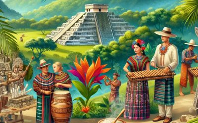
Cultural or Historical Sites of Guatemala: Important Cultural Landmarks or Historical Sites in Guatemala
The ancient Mayan ruins of Tikal are one of the most impressive archaeological sites in the world. Located in the heart of the Guatemalan jungle, Tikal was once a powerful city and ceremonial center of the Mayan civilization. The site is home to towering pyramids, majestic temples, and intricate stone carvings that offer a glimpse into the rich history and culture of the Mayan people. The Great Plaza, with its iconic Temple I and Temple II, is a testament to the architectural and engineering prowess of the ancient Mayans. The site also features a network of causeways, reservoirs, and agricultural terraces, showcasing the advanced urban planning and agricultural techniques of the Mayan civilization. Tikal is not only a historical treasure but also a natural wonder. The site is surrounded by lush rainforest teeming with wildlife, including howler monkeys, toucans, and jaguars. Visitors can explore the site on foot or climb to the top of the pyramids for breathtaking views of the jungle canopy. The experience of standing atop a Mayan pyramid, surrounded by the sights and sounds of the rainforest, is truly awe-inspiring. Tikal is a must-visit destination for history enthusiasts, nature lovers, and anyone seeking a deeper understanding of the ancient Mayan civilization. Summary Tikal is one of the largest archaeological sites and urban centers of the pre-Columbian Maya civilization. Antigua is a UNESCO World Heritage site known for its well-preserved Spanish colonial architecture. Chichicastenango hosts one of the most famous markets in Guatemala, where indigenous people sell their traditional crafts and produce. Quirigua is home to some of the most important Mayan ruins, known for its impressive...

Terrain and Topography of Guatemala: mountains, valleys, and plains.
Guatemala, located in Central America, is a country known for its diverse and stunning terrain. The topography of Guatemala is characterized by its majestic mountains, lush valleys, and vast plains. The country is also home to several active volcanoes, making it a land of both beauty and danger. The terrain of Guatemala has played a significant role in shaping the country’s climate, agriculture, and overall way of life. Understanding the diverse terrain of Guatemala is essential for appreciating the challenges and opportunities it presents to the people who call this beautiful country home. Guatemala’s terrain is a result of its location along the Pacific Ring of Fire, a region known for its volcanic activity and seismic events. The country is home to over 30 volcanoes, some of which are still active. These volcanoes have contributed to the rugged and mountainous landscape of Guatemala, creating breathtaking vistas and challenging living conditions for the people who reside in these areas. The terrain also includes lush valleys and vast plains, providing a stark contrast to the towering mountains and volcanic peaks. The diverse topography of Guatemala has made it a land of great natural beauty, attracting visitors from around the world to marvel at its landscapes. Summary Guatemala’s terrain is diverse, with a combination of mountains, valleys, and plains. The majestic mountains of Guatemala, including the volcanic peaks, offer stunning natural beauty and opportunities for adventure tourism. The lush valleys of Guatemala are fertile and support a variety of agricultural activities, including coffee and fruit production. The vast plains of Guatemala provide important grazing land for livestock and are also used for...

History of Guatemala
The ancient Mayan civilization, which flourished in present-day Guatemala and other parts of Central America, is renowned for its advanced knowledge of astronomy, mathematics, and architecture. The Mayans built impressive cities with intricate stone temples and palaces, and they developed a sophisticated writing system using hieroglyphs. Their society was highly stratified, with a ruling class of nobles and priests who wielded significant power over the common people. The Mayans were also skilled farmers, cultivating crops such as maize, beans, and squash using advanced agricultural techniques. The Mayans were deeply religious, worshipping a pantheon of deities and conducting elaborate rituals to appease their gods. They believed in the cyclical nature of time and the universe, and their calendar system was incredibly accurate, allowing them to predict celestial events with precision. The Mayans also engaged in trade with other Mesoamerican cultures, exchanging goods such as jade, obsidian, and cacao. Despite their remarkable achievements, the Mayan civilization began to decline around the 9th century, for reasons that are still not fully understood. The once-thriving cities were abandoned, and the Mayan people dispersed into smaller communities, leaving behind a legacy of architectural marvels and intellectual achievements that continue to fascinate scholars and visitors alike. Summary The Ancient Mayan Civilization was a highly advanced society with impressive achievements in architecture, mathematics, and astronomy. The Spanish Conquest and Colonial Rule brought about the forced conversion of the Mayan people to Christianity and the exploitation of their labour and resources. Independence and the United Provinces of Central America marked a period of political instability and economic struggles for Guatemala. The United Fruit Company and American Influence...

Population Density of Guatemala
Population density refers to the number of people living in a specific area, usually measured in square kilometres or square miles. It is an important demographic indicator that helps us understand the distribution of people within a given area. In the case of Guatemala, a country located in Central America, population density plays a crucial role in shaping the social, economic, and environmental landscape of the nation. With a total land area of 108,889 square kilometres and a population of over 17 million people, Guatemala’s population density stands at around 157 people per square kilometre. This places Guatemala among the countries with a relatively high population density in the region. The study of population density is essential for understanding the spatial distribution of people and its implications for resource allocation, urban planning, and social development. In Guatemala, population density varies significantly across different regions, with urban areas experiencing higher concentrations of people compared to rural areas. Understanding the factors that influence population density in Guatemala is crucial for policymakers and urban planners to make informed decisions about resource allocation and infrastructure development. Summary Population density refers to the number of people living in a specific area, usually measured in square kilometres or square miles. Factors affecting population density in Guatemala include natural resources, economic opportunities, and historical settlement patterns. Urban areas in Guatemala have higher population density compared to rural areas due to better access to jobs, education, and healthcare. High population density can strain infrastructure and services, leading to challenges in providing adequate housing, transportation, and healthcare. Government policies and initiatives in Guatemala aim to manage population density...
Guatemala
Guatemala (República de Guatemala (Republic of Guatemala)) Capital: Guatemala City Population (Estimated July 2012): 14,099,032 Area: 109,117 km2 or 42,130 mi2 Currency: Quetzal (Q) Official Language: Spanish Political Information: Unitary Presidential Constitutional Republic Official Religion: No Official Religion (Roman Catholic, Protestant and Indigenous Mayan religious beliefs are most common) Highest Mountain: Volcán Tajumulco 4,220m or 13,845 ft GDP Official Exchange Rate (OER is more precise at gauging a country’s economic power) (Estimated 2011): $46.7 billion (US$) or (GBP) GDP (OER) Per Capita (per member of the population estimated 2011): (US$) or (GBP) GDP Purchasing Power Parity (PPP is good for gauging living conditions and the use of resources but is not as accurate as OER. This data has been calculated based on the sum value of all goods and services produced in the country valued at prices prevailing in the United States) (Estimated 2011): $74.64 billion (US$) or (GBP) GDP (PPP) Per Capita (per member of the population estimated 2011): $5,000 (US$) or (GBP) Time Zone (GMT/UTC): -6:00 Wildlife: Counties/Provinces/States: 22 Departments (departamentos, singular – departamento); Alta Verapaz, Baja Verapaz, Chimaltenango, Chiquimula, El Progreso, Escuintla, Guatemala, Huehuetenango, Izabal, Jalapa, Jutiapa, Peten, Quetzaltenango, Quiche, Retalhuleu, Sacatepequez, San Marcos, Santa Rosa, Solola, Suchitepequez, Totonicapan, Zacapa Leaders: President Otto Pérez Molina and Vice President Roxana Baldetti Additional: Gained independence From Spain on the 15th of September 1821. Sources: CIA World Fact Book, Encyclopaedia...

Climate Zones of Grenada: Different climate regions Of Grenada
Grenada, known as the “Spice Isle” due to its production of nutmeg and other spices, is a small island country located in the Caribbean. The country is known for its diverse climate zones, which range from tropical rainforests to semi-arid regions. The climate in Grenada is influenced by its location in the Caribbean Sea, as well as its topography, which includes mountainous terrain and coastal areas. These factors contribute to the variety of climate zones found within the country, each with its own unique characteristics and impact on the environment and agriculture. The diverse climate zones in Grenada play a significant role in shaping the country’s natural environment and agricultural practices. From the lush rainforests in the interior to the arid coastal regions, each climate zone presents its own set of challenges and opportunities for the people and ecosystems of Grenada. Understanding the distinct characteristics of each climate zone is essential for managing natural resources, conserving biodiversity, and sustaining agricultural production in the country. Summary Grenada has diverse climate zones, including tropical rainforest, subtropical highland, semi-arid, and coastal climates. The tropical rainforest climate in Grenada is characterized by high temperatures, heavy rainfall, and lush vegetation. The subtropical highland climate in Grenada features cooler temperatures and is ideal for growing crops such as coffee and cocoa. Grenada’s semi-arid climate experiences low rainfall and high temperatures, making it challenging for agriculture. The coastal climate in Grenada is influenced by the sea, with warm temperatures and moderate rainfall. Tropical Rainforest Climate in Grenada Grenada’s interior regions are characterized by a tropical rainforest climate, with high levels of rainfall and humidity throughout the...

Political Boundaries of Grenada: Provinces, Districts, or Historical Boundaries.
Grenada, a small island country located in the Caribbean, is known for its stunning natural beauty and rich cultural heritage. The political boundaries of Grenada play a crucial role in shaping the governance and administration of the country. The political boundaries of Grenada are defined by its provinces and districts, which are essential for the effective functioning of the government and the delivery of public services. Understanding the political boundaries of Grenada is vital for comprehending the country’s political landscape and the distribution of power and resources within its territory. The political boundaries of Grenada are a reflection of its historical development and the complex interplay of social, economic, and geographical factors. The provinces and districts of Grenada are not just administrative divisions but also represent the diverse cultural and social identities within the country. The political boundaries of Grenada have evolved over time, influenced by colonial legacies, demographic changes, and political considerations. As such, they are a dynamic and contested aspect of the country’s governance, with implications for representation, resource allocation, and local autonomy. Summary Grenada is a small island nation in the Caribbean with distinct political boundaries. The country is divided into six parishes, each with its own unique characteristics and governance. Within the parishes, there are 17 administrative districts that play a crucial role in local governance and development. Grenada’s political boundaries have evolved over time, influenced by colonial history and geopolitical factors. The impact of political boundaries on governance in Grenada has led to challenges and controversies, particularly in terms of resource allocation and representation. Provinces of Grenada Grenada is divided into six administrative regions...