World Geography
Geography is the study of the Earth’s landscapes, environments, and the relationships between people and their surroundings. It encompasses both the physical aspects of the Earth, such as its landforms, bodies of water, and climate, as well as the human aspects, including population distribution, cultures, and economies. World geography is a broad field that seeks to understand the complexities of our planet and how humans interact with it. By studying world geography, we can gain a deeper appreciation for the diversity of our planet and the interconnectedness of its various regions.
Geography is a multidisciplinary field that draws on elements of physical science, social science, and humanities. It involves the use of maps, spatial analysis, and geographic information systems (GIS) to understand the Earth’s surface and the processes that shape it. World geography also encompasses the study of human geography, which examines the ways in which people and their activities are distributed across the Earth. By understanding world geography, we can better appreciate the environmental, cultural, and economic challenges facing different regions of the world. This knowledge is crucial for addressing global issues such as climate change, resource management, and international development.
The Five Oceans and Seven Continents
The Earth’s surface is divided into five major oceans: the Pacific, Atlantic, Indian, Southern (or Antarctic), and Arctic Oceans. These vast bodies of water play a crucial role in regulating the Earth’s climate and supporting diverse marine ecosystems. The oceans also serve as important transportation routes and a source of food and other natural resources for human societies around the world.
In addition to the oceans, the Earth’s landmasses are divided into seven continents: Africa, Antarctica, Asia, Europe, North America, Australia (or Oceania), and South America. Each continent has its own unique physical and cultural characteristics, shaped by millions of years of geological processes and human history. From the deserts of Africa to the rainforests of South America, the continents offer a rich tapestry of landscapes and environments for exploration and study.
Major Mountain Ranges and Deserts
The Earth’s surface is also marked by major mountain ranges and deserts that have shaped the planet’s physical and cultural landscapes. The Himalayas, for example, are the highest mountain range in the world and are home to diverse ecosystems and cultures in countries such as India, Nepal, and Bhutan. The Andes in South America, the Rockies in North America, and the Alps in Europe are other prominent mountain ranges that have influenced human settlement patterns and economic activities.
Deserts cover about one-third of the Earth’s land surface and are characterized by low precipitation and extreme temperatures. The Sahara Desert in Africa is the largest hot desert in the world, while the Gobi Desert in Asia is one of the largest cold deserts. Deserts are not only home to unique flora and fauna but have also been important trade routes and cultural crossroads throughout history.
Climate Zones and Biomes
The Earth’s climate is influenced by a variety of factors, including latitude, altitude, ocean currents, and prevailing winds. As a result, the planet is divided into different climate zones, each with its own characteristic weather patterns and ecosystems. The equator, for example, experiences a tropical climate with high temperatures and heavy rainfall, while the polar regions have a cold and dry climate.
These climate zones give rise to different biomes, or large ecological areas characterized by distinct plant and animal communities. The tropical rainforest biome, found near the equator, is home to a diverse array of species and is vital for regulating the Earth’s climate. The grasslands biome, found in regions such as the African savannah and North American prairies, supports grazing animals and has been important for human agriculture throughout history.
Human Geography and Population Distribution
Human geography examines the ways in which people and their activities are distributed across the Earth’s surface. It encompasses topics such as population growth, migration patterns, urbanization, and cultural diversity. Understanding human geography is crucial for addressing global challenges such as poverty, inequality, and environmental degradation.
Population distribution is uneven across the world, with some regions experiencing rapid population growth while others are declining. The majority of the world’s population lives in Asia, particularly in countries such as China and India. Urban areas are also growing rapidly, with more than half of the world’s population now living in cities. This trend has significant implications for infrastructure development, resource management, and social inequality.
Historical and Cultural Geography
Historical geography examines how human activities have shaped the Earth’s landscapes over time. It explores topics such as colonialism, trade routes, and the rise and fall of empires. Cultural geography focuses on how human cultures have developed in different regions of the world and how they interact with their environments.
The Silk Road, for example, was an ancient trade route that connected China with Europe and facilitated the exchange of goods, ideas, and technologies across Eurasia. This historical trade route had a profound impact on the development of cultures and economies along its path. Similarly, cultural geographers study how different societies have adapted to their environments through practices such as agriculture, architecture, and religious beliefs.
The Importance of Geographic Knowledge
Geographic knowledge is crucial for addressing global challenges such as climate change, resource management, and international development. By understanding world geography, we can better appreciate the environmental, cultural, and economic challenges facing different regions of the world. This knowledge is crucial for addressing global issues such as climate change, resource management, and international development.
Geographic knowledge also helps us to understand our interconnectedness with other regions of the world. By studying world geography, we can gain a deeper appreciation for the diversity of our planet and the interconnectedness of its various regions. This understanding can foster a sense of global citizenship and empathy for people from different cultures and backgrounds.
In conclusion, world geography is a complex and multifaceted field that encompasses both physical and human aspects of the Earth’s landscapes. By studying world geography, we can gain a deeper appreciation for the diversity of our planet and the interconnectedness of its various regions. This knowledge is crucial for addressing global challenges such as climate change, resource management, and international development. It also helps us to understand our interconnectedness with other regions of the world and fosters a sense of global citizenship.
FAQs
What is world geography?
World geography is the study of the Earth’s landscapes, environments, and the relationships between people and their environments. It encompasses the physical features of the Earth, as well as the human activity that takes place on it.
Why is world geography important?
World geography is important because it helps us understand the world around us. It provides insights into the physical and human processes that shape our planet, and helps us make informed decisions about how to interact with our environment.
What are the main branches of world geography?
The main branches of world geography include physical geography, which focuses on the Earth’s natural features and processes, and human geography, which examines the relationships between people and their environments.
How does world geography impact our daily lives?
World geography impacts our daily lives in numerous ways, from influencing the weather and climate we experience, to shaping the availability of natural resources and influencing the distribution of populations and cultures around the world.
What are some key concepts in world geography?
Key concepts in world geography include location, place, human-environment interaction, movement, and region. These concepts help geographers understand and interpret the world around them.

Political Boundaries of Jordan: Provinces, Districts, or Historical Boundaries.
Jordan, officially known as the Hashemite Kingdom of Jordan, is a country located in the Middle East, bordered by Saudi Arabia to the south and east, Iraq to the north-east, Syria to the north, and Israel and Palestine to the west. The country has a rich history and is known for its diverse cultural heritage, ancient ruins, and stunning landscapes. Jordan’s political boundaries have evolved over time, influenced by historical, geographical, and geopolitical factors. The country’s borders have been shaped by various treaties, agreements, and conflicts, which have had a significant impact on its governance and administration. The political boundaries of Jordan play a crucial role in defining the country’s territorial integrity and sovereignty. They determine the extent of Jordan’s jurisdiction and authority over its territory, as well as its relationships with neighbouring countries. The delineation of these boundaries has been a complex and contentious issue, shaped by historical events, colonial legacies, and regional power dynamics. Understanding Jordan’s political boundaries is essential for comprehending the country’s governance structure, administrative divisions, and historical context. Summary Jordan’s political boundaries have evolved over time, shaping the country’s governance and administration. The administrative divisions of Jordan are divided into 12 provinces, each with its own governor appointed by the central government. Local governance in Jordan is further divided into districts, each with its own council responsible for local administration and development. The historical boundaries of Jordan have been influenced by ancient and modern geopolitical factors, impacting the country’s territorial integrity and sovereignty. The political boundaries of Jordan have significant implications for the country’s governance, including challenges and controversies surrounding border disputes and refugee...

Terrain and Topography of Jordan: mountains, valleys, and plains.
Jordan is a country located in the Middle East, with a diverse and varied terrain and topography that makes it a unique and fascinating destination for travellers and nature enthusiasts. The country is home to a wide range of landscapes, including majestic mountains, magnificent valleys, and vast plains, each with its own distinct characteristics and beauty. From the towering peaks of the Jordanian highlands to the sprawling deserts of the east, Jordan’s terrain and topography offer a rich tapestry of natural wonders that are waiting to be explored and appreciated. The terrain of Jordan is largely defined by its location at the crossroads of three continents – Africa, Asia, and Europe. This geographical position has resulted in a diverse and varied landscape that is characterised by dramatic contrasts and breathtaking scenery. From the rugged mountains of the north to the arid deserts of the south, Jordan’s terrain and topography are a testament to the country’s rich natural heritage and geological history. With its diverse range of ecosystems and habitats, Jordan is home to a wide variety of plant and animal species, making it a haven for biodiversity and a paradise for nature lovers. Summary Jordan’s terrain and topography are diverse, ranging from mountains to valleys and plains. The majestic mountains of Jordan, such as the Ajloun and Dana mountains, offer stunning natural beauty and opportunities for outdoor activities. The magnificent valleys of Jordan, including the Jordan Valley and Wadi Rum, are known for their unique landscapes and historical significance. The vast plains of Jordan, like the Jordanian Desert and the Eastern Desert, contribute to the country’s diverse terrain and...

Climate Zones of Jordan: Different climate regions Of Jordan
Jordan is a country located in the Middle East, with a diverse range of climate zones due to its varied topography and geographical location. The climate in Jordan can be classified into several distinct regions, each with its own unique characteristics and weather patterns. These climate zones include the Mediterranean, desert, highland, arid, semi-arid, and steppe regions. Each of these regions has a significant impact on the environment, agriculture, and daily life of the people living in these areas. The diverse climate zones in Jordan are a result of the country’s location between the Mediterranean Sea and the Arabian Desert. The varying elevations and geographical features also contribute to the different climate patterns experienced across the country. Understanding these climate zones is crucial for anyone looking to visit or live in Jordan, as it can greatly affect travel plans, outdoor activities, and overall comfort. In this article, we will explore each of these climate regions in detail, providing insight into the unique characteristics and weather patterns of each area. Summary Jordan has diverse climate zones, including the Mediterranean, Desert, Highland, Arid, Semi-arid, and Steppe regions. The Mediterranean climate region in Jordan is characterized by mild, wet winters and hot, dry summers. The Desert climate region in Jordan experiences extremely hot and dry conditions, with very little rainfall. The Highland climate region in Jordan has cooler temperatures and more precipitation due to its higher elevation. The Arid climate region in Jordan is extremely dry and experiences very high temperatures, with little to no rainfall. The Mediterranean Climate Region The Mediterranean climate region in Jordan is located in the northwest part...

History of Jordan
Jordan has a rich and diverse history that dates back to ancient times. The region that is now Jordan was home to several ancient civilizations, including the Ammonites, Edomites, and Moabites. These ancient peoples left behind a wealth of archaeological treasures, including impressive ruins, temples, and tombs. The city of Jerash, for example, is home to some of the best-preserved Roman ruins in the world, while the ancient city of Petra is a UNESCO World Heritage site and one of the New Seven Wonders of the World. The ancient civilizations of Jordan were known for their advanced architecture, art, and engineering. The Nabateans, in particular, were skilled builders and craftsmen, as evidenced by the intricate carvings and structures at Petra. The region was also an important trade route, connecting the Mediterranean world with the Arabian Peninsula and beyond. This made it a melting pot of cultures and ideas, leading to a rich tapestry of traditions and beliefs. The ancient civilizations of Jordan laid the foundation for the region’s cultural and historical identity, and their legacy can still be seen and felt today. Jordan’s ancient civilizations also made significant contributions to art, literature, and philosophy. The Nabateans, for example, were known for their intricate rock-cut architecture and sophisticated water management systems. The city of Petra, their most famous achievement, is a testament to their engineering prowess and artistic sensibilities. The ancient city is home to impressive structures such as the Treasury and the Monastery, which showcase the Nabateans’ mastery of stone carving and design. Additionally, the region was a hub for trade and commerce, leading to the exchange of ideas...

Natural Resources of Jordan: Where Natural Resources are Located in Jordan
Jordan is a country rich in natural resources, despite its arid climate and limited land area. The country is strategically located in the Middle East, sharing borders with Israel, Syria, Iraq, and Saudi Arabia. Jordan‘s natural resources include water, minerals, agriculture, energy, and stunning landscapes that attract tourists from around the world. The sustainable management of these resources is crucial for the country’s economic development and environmental preservation. Summary Jordan is rich in natural resources, including water, minerals, agriculture, energy, and tourism attractions. Water scarcity is a major challenge in Jordan, with the country being one of the most water-poor in the world. Jordan has significant mineral resources, including phosphate, potash, and oil shale, which are important for the country’s economy. Agriculture is a vital sector in Jordan, with the country producing a variety of crops despite its arid climate. Jordan is working towards developing its renewable energy sector to reduce its reliance on imported energy resources. Water Resources in Jordan Water is a precious resource in Jordan, where the climate is predominantly arid. The country faces significant challenges in meeting the water needs of its growing population and agricultural sector. Jordan’s main sources of water include surface water from the Jordan River and underground water from aquifers. However, these sources are under pressure due to over-extraction, pollution, and climate change. The government has implemented various water management strategies, such as water conservation measures, wastewater treatment, and the development of desalination plants. Additionally, international cooperation with neighbouring countries on water sharing agreements is essential for ensuring sustainable access to water resources in the region. Jordan’s water resources are vital...

Cultural or Historical Sites of Jordan: Important Cultural Landmarks or Historical Sites In Jordan
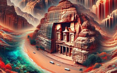
The ancient city of Petra, nestled in the rugged mountains of southern Jordan, is a UNESCO World Heritage Site and one of the most iconic archaeological sites in the world. Known as the “Rose City” due to the pink hue of its rock-cut architecture, Petra was the capital of the Nabatean Kingdom and flourished as a major trading hub from the 4th century BC to the 2nd century AD. The city’s most famous structure is the Treasury, carved into the sandstone cliff and adorned with intricate carvings and columns. As visitors pass through the narrow Siq, a natural rock formation, they are greeted with the awe-inspiring sight of the Treasury, which has been featured in numerous films and is a symbol of Jordan‘s rich history and cultural heritage. Beyond the Treasury, Petra is home to a wealth of archaeological wonders, including the Royal Tombs, the Roman Theatre, and the Monastery, all of which showcase the advanced engineering and artistic skills of the Nabateans. The city’s complex water management system, which allowed it to thrive in the arid desert environment, is a testament to the ingenuity of its ancient inhabitants. Exploring Petra is a journey back in time, as visitors wander through the ancient streets, marvel at the intricate rock-cut facades, and imagine the bustling city that once stood at the crossroads of ancient trade routes. With its rich history and stunning natural beauty, Petra continues to captivate and inspire visitors from around the world. Summary Petra is a UNESCO World Heritage Site and one of the most famous archaeological sites in the world. Jerash is a testament to Jordan’s...

Population Density of Jordan
Jordan is a small country located in the Middle East, with a population density of around 113 people per square kilometer. The population density in Jordan is unevenly distributed, with the majority of the population concentrated in urban areas such as the capital city of Amman. The country’s population density has been steadily increasing over the years, posing various challenges for the government in terms of managing resources, infrastructure, and social services. Understanding the factors influencing population density in Jordan is crucial for developing effective policies and initiatives to manage and sustain the country’s population growth. Jordan’s population density is influenced by a variety of factors, including geographical features, economic opportunities, and government policies. The country’s diverse landscape, which includes deserts, mountains, and fertile valleys, has a significant impact on population distribution. Urban areas such as Amman and Zarqa are attractive to migrants due to the availability of employment opportunities, educational institutions, and healthcare facilities. Additionally, the influx of refugees from neighbouring countries has also contributed to the increase in population density in certain regions. As a result, the government has been faced with the challenge of providing adequate infrastructure and resources to support the growing population. Summary Jordan has a population density of 113 people per square kilometre, making it one of the most densely populated countries in the Middle East. Factors influencing population density in Jordan include urbanisation, economic opportunities, and natural resources. The majority of Jordan’s population is concentrated in urban areas, with Amman being the most densely populated city. High population density in urban areas puts pressure on infrastructure, housing, and resources such as water...
Jordan
Jordan (Al-Mamlakah al-Urduniyyah al-Hāshimiyyah (Hashemite Kingdom of Jordan)) Capital: Amman Population (Estimated July 2012): 6,508,887 Area: 88,778 km2 or 34,277 mi2 Currency: Jordanian Dinar (JD) Official Language: Arabic Political Information: Constitutional Monarchy Official Religion: Islam(approximately 92% of the population are Sunni Muslim, 6% are Christian of various denominations and 2% have other religious beliefs) Highest Mountain: Jabal Umm ad Dami at 1,854m or 6,083ft GDP Official Exchange Rate (OER is more precise at gauging a country’s economic power) (Estimated 2011): $28.4 billion (US$) or (GBP) GDP (OER) Per Capita (per member of the population estimated 2011): (US$) or (GBP) GDP Purchasing Power Parity (PPP is good for gauging living conditions and the use of resources but is not as accurate as OER. This data has been calculated based on the sum value of all goods and services produced in the country valued at prices prevailing in the United States) (Estimated 2011): $36.82 billion (US$) or (GBP) GDP (PPP) Per Capita (per member of the population estimated 2011): $5,900 (US$) or (GBP) Time Zone (GMT/UTC): +2:00 Wildlife: Counties/Provinces/States: 12 governorates (muhafazat, singular – muhafazah); Ajlun, Al ‘Aqabah, Al Balqa’, Al Karak, Al Mafraq, ‘Amman, At Tafilah, Az Zarqa’, Irbid, Jarash, Ma’an, Madaba Leaders: King Abdullah II with Prime Minister Awn Shawkat al-Khasawneh. Additional: Gained Independence from British administration on the 25th of May 1946. Sources: CIA World Fact Book, Encyclopaedia Britannica. Jordan Jordan, officially known as the Hashemite Kingdom of Jordan, is a country located in the Middle East. It is bordered by Saudi Arabia to the south and east, Iraq to the north-east, Syria to the north, and Israel and Palestine to the west. The capital city of Jordan...

Political Boundaries of Japan: Provinces, Districts, or Historical Boundaries.
Political boundaries in Japan have played a significant role in shaping the country’s history, culture, and administrative divisions. From ancient provinces and districts to modern prefectures and municipalities, Japan‘s political boundaries have evolved over centuries, reflecting the country’s social, economic, and political changes. Understanding the historical background and modern administrative divisions of Japan is crucial to comprehending the role of political boundaries in shaping the country’s society and culture. Moreover, the challenges and controversies surrounding political boundaries in Japan, as well as their impact on Japanese society, highlight the complexity and significance of this topic. Looking towards the future, it is essential to consider the potential prospects for the political boundaries of Japan and their implications for the country’s governance and development. Summary Japan’s political boundaries have evolved over centuries, shaping the country’s administrative divisions and societal structure. Provinces and districts in Japan have a rich historical background, reflecting the country’s feudal past and the influence of the samurai class. Modern administrative divisions in Japan are based on a combination of historical boundaries and contemporary governance needs. Historical boundaries continue to play a significant role in modern Japan, influencing regional identity and cultural practices. Challenges and controversies surrounding political boundaries in Japan reflect the complex interplay of historical, cultural, and political factors, impacting society and governance. Historical Background of Provinces and Districts in Japan The historical development of political boundaries in Japan can be traced back to the ancient provinces and districts that existed during the classical and medieval periods. These provinces, known as “kuni,” were established as early as the 7th century and served as administrative units for...

Cultural or Historical Sites of Japan: Important Cultural Landmarks or Historical Sites In Japan
Japan is a country rich in history and culture, with a plethora of cultural and historical sites that attract millions of visitors from around the world each year. From ancient temples and shrines to traditional gardens and historical districts, Japan offers a diverse range of attractions that showcase its unique heritage. The country’s long and storied history is reflected in its UNESCO World Heritage Sites, ancient castles and palaces, and museums and art galleries that house priceless artefacts and artworks. Japanese culture is deeply rooted in tradition, and this is evident in the preservation of its historical sites, which provide a window into the country’s past. Whether it’s the serene beauty of a traditional Japanese garden or the imposing grandeur of a feudal castle, Japan’s cultural and historical sites offer a fascinating glimpse into the country’s rich heritage. Japan’s cultural and historical sites are not only important for preserving the country’s past, but they also play a crucial role in shaping its future. These sites are not just tourist attractions, but also serve as important educational and cultural landmarks that help to foster a sense of national identity and pride. Many of Japan’s historical sites are also places of worship and pilgrimage, where visitors can experience the spiritual and religious traditions that have been passed down through generations. From the bustling streets of Tokyo to the tranquil countryside, Japan’s cultural and historical sites are an integral part of the country’s landscape, offering a diverse range of experiences for visitors to explore and enjoy. Whether it’s exploring ancient temples and shrines, strolling through traditional gardens, or immersing oneself in the...

Natural Resources of Japan: Where Natural Resources are located In Japan
Japan is a country with a diverse range of natural resources, including forests, minerals, marine resources, agricultural land, and renewable energy sources. These resources have played a crucial role in the development and growth of the Japanese economy over the years. Japan’s natural resources have also contributed to its cultural heritage and traditional practices, making them an integral part of the country’s identity. The sustainable management and utilization of these natural resources are essential for Japan’s future development and environmental conservation. With a growing population and increasing demand for energy and raw materials, Japan faces the challenge of balancing economic growth with environmental protection. Understanding the distribution, abundance, and challenges associated with these natural resources is crucial for ensuring their sustainable use and conservation for future generations. Summary Japan is rich in natural resources, including forests, minerals, marine resources, agricultural land, and renewable energy sources. The forests and timber resources in Japan are mainly located in the mountainous regions, with a focus on sustainable management and conservation. Japan has abundant mineral resources, including coal, copper, and iron, which are essential for its industrial development. The waters surrounding Japan are rich in marine resources, providing a variety of seafood and supporting a thriving fishing industry. Agricultural resources and farmland in Japan are limited, but the country has advanced technology and efficient farming practices to maximise productivity. Japan is investing in renewable energy resources, such as solar and wind power, to reduce its reliance on imported fossil fuels and promote sustainability. Despite its natural resource richness, Japan faces challenges in sustainable management, conservation, and balancing economic development with environmental protection. Location...

Climate Zones of Japan: Different climate regions Of Japan
Japan is a country known for its diverse climate zones, ranging from the cool temperate climate of Hokkaido in the north to the subtropical climate of Okinawa in the south. The country’s unique geography, which includes mountain ranges, coastal plains, and numerous islands, plays a significant role in shaping its climate. Understanding Japan‘s climate zones is essential for anyone planning to visit or live in the country, as it can greatly impact the activities and lifestyle choices available in each region. In this article, we will explore the influence of geography on Japan’s climate, as well as the specific characteristics of each climate zone, from Hokkaido to Okinawa. Additionally, we will discuss the impact of climate change on Japan’s climate zones and how it may affect the country in the future. Summary Japan has a diverse climate due to its geographical location and topography, resulting in various climate zones across the country. The northern island of Hokkaido experiences a temperate climate with long, cold winters and mild summers, influenced by its proximity to Siberia and the Sea of Japan. The southern island of Okinawa has a subtropical climate with hot and humid summers, and mild winters, influenced by its location in the East China Sea. The main island of Honshu has a humid continental climate with hot, humid summers and cold, snowy winters, influenced by its central location and mountainous terrain. The regions of Shikoku and Kyushu experience climate variability, with a mix of temperate, subtropical, and humid subtropical climates due to their proximity to the Pacific Ocean and the East China Sea. Climate change is impacting Japan’s climate...