World Geography
Geography is the study of the Earth’s landscapes, environments, and the relationships between people and their surroundings. It encompasses both the physical aspects of the Earth, such as its landforms, bodies of water, and climate, as well as the human aspects, including population distribution, cultures, and economies. World geography is a broad field that seeks to understand the complexities of our planet and how humans interact with it. By studying world geography, we can gain a deeper appreciation for the diversity of our planet and the interconnectedness of its various regions.
Geography is a multidisciplinary field that draws on elements of physical science, social science, and humanities. It involves the use of maps, spatial analysis, and geographic information systems (GIS) to understand the Earth’s surface and the processes that shape it. World geography also encompasses the study of human geography, which examines the ways in which people and their activities are distributed across the Earth. By understanding world geography, we can better appreciate the environmental, cultural, and economic challenges facing different regions of the world. This knowledge is crucial for addressing global issues such as climate change, resource management, and international development.
The Five Oceans and Seven Continents
The Earth’s surface is divided into five major oceans: the Pacific, Atlantic, Indian, Southern (or Antarctic), and Arctic Oceans. These vast bodies of water play a crucial role in regulating the Earth’s climate and supporting diverse marine ecosystems. The oceans also serve as important transportation routes and a source of food and other natural resources for human societies around the world.
In addition to the oceans, the Earth’s landmasses are divided into seven continents: Africa, Antarctica, Asia, Europe, North America, Australia (or Oceania), and South America. Each continent has its own unique physical and cultural characteristics, shaped by millions of years of geological processes and human history. From the deserts of Africa to the rainforests of South America, the continents offer a rich tapestry of landscapes and environments for exploration and study.
Major Mountain Ranges and Deserts
The Earth’s surface is also marked by major mountain ranges and deserts that have shaped the planet’s physical and cultural landscapes. The Himalayas, for example, are the highest mountain range in the world and are home to diverse ecosystems and cultures in countries such as India, Nepal, and Bhutan. The Andes in South America, the Rockies in North America, and the Alps in Europe are other prominent mountain ranges that have influenced human settlement patterns and economic activities.
Deserts cover about one-third of the Earth’s land surface and are characterized by low precipitation and extreme temperatures. The Sahara Desert in Africa is the largest hot desert in the world, while the Gobi Desert in Asia is one of the largest cold deserts. Deserts are not only home to unique flora and fauna but have also been important trade routes and cultural crossroads throughout history.
Climate Zones and Biomes
The Earth’s climate is influenced by a variety of factors, including latitude, altitude, ocean currents, and prevailing winds. As a result, the planet is divided into different climate zones, each with its own characteristic weather patterns and ecosystems. The equator, for example, experiences a tropical climate with high temperatures and heavy rainfall, while the polar regions have a cold and dry climate.
These climate zones give rise to different biomes, or large ecological areas characterized by distinct plant and animal communities. The tropical rainforest biome, found near the equator, is home to a diverse array of species and is vital for regulating the Earth’s climate. The grasslands biome, found in regions such as the African savannah and North American prairies, supports grazing animals and has been important for human agriculture throughout history.
Human Geography and Population Distribution
Human geography examines the ways in which people and their activities are distributed across the Earth’s surface. It encompasses topics such as population growth, migration patterns, urbanization, and cultural diversity. Understanding human geography is crucial for addressing global challenges such as poverty, inequality, and environmental degradation.
Population distribution is uneven across the world, with some regions experiencing rapid population growth while others are declining. The majority of the world’s population lives in Asia, particularly in countries such as China and India. Urban areas are also growing rapidly, with more than half of the world’s population now living in cities. This trend has significant implications for infrastructure development, resource management, and social inequality.
Historical and Cultural Geography
Historical geography examines how human activities have shaped the Earth’s landscapes over time. It explores topics such as colonialism, trade routes, and the rise and fall of empires. Cultural geography focuses on how human cultures have developed in different regions of the world and how they interact with their environments.
The Silk Road, for example, was an ancient trade route that connected China with Europe and facilitated the exchange of goods, ideas, and technologies across Eurasia. This historical trade route had a profound impact on the development of cultures and economies along its path. Similarly, cultural geographers study how different societies have adapted to their environments through practices such as agriculture, architecture, and religious beliefs.
The Importance of Geographic Knowledge
Geographic knowledge is crucial for addressing global challenges such as climate change, resource management, and international development. By understanding world geography, we can better appreciate the environmental, cultural, and economic challenges facing different regions of the world. This knowledge is crucial for addressing global issues such as climate change, resource management, and international development.
Geographic knowledge also helps us to understand our interconnectedness with other regions of the world. By studying world geography, we can gain a deeper appreciation for the diversity of our planet and the interconnectedness of its various regions. This understanding can foster a sense of global citizenship and empathy for people from different cultures and backgrounds.
In conclusion, world geography is a complex and multifaceted field that encompasses both physical and human aspects of the Earth’s landscapes. By studying world geography, we can gain a deeper appreciation for the diversity of our planet and the interconnectedness of its various regions. This knowledge is crucial for addressing global challenges such as climate change, resource management, and international development. It also helps us to understand our interconnectedness with other regions of the world and fosters a sense of global citizenship.
FAQs
What is world geography?
World geography is the study of the Earth’s landscapes, environments, and the relationships between people and their environments. It encompasses the physical features of the Earth, as well as the human activity that takes place on it.
Why is world geography important?
World geography is important because it helps us understand the world around us. It provides insights into the physical and human processes that shape our planet, and helps us make informed decisions about how to interact with our environment.
What are the main branches of world geography?
The main branches of world geography include physical geography, which focuses on the Earth’s natural features and processes, and human geography, which examines the relationships between people and their environments.
How does world geography impact our daily lives?
World geography impacts our daily lives in numerous ways, from influencing the weather and climate we experience, to shaping the availability of natural resources and influencing the distribution of populations and cultures around the world.
What are some key concepts in world geography?
Key concepts in world geography include location, place, human-environment interaction, movement, and region. These concepts help geographers understand and interpret the world around them.

Cultural or Historical Sites of Indonesia: Important Cultural Landmarks or Historical Sites In Indonesia
Cultural or Historical Sites of Indonesia: Important Cultural Landmarks or Historical Sites In Indonesia Borobudur Temple is a UNESCO World Heritage Site located in Central Java, Indonesia. This ancient Buddhist temple is one of the most important and well-preserved monuments in the world. Built in the 9th century during the reign of the Sailendra Dynasty, Borobudur is a masterpiece of Indonesian architecture and a symbol of Indonesia’s rich cultural heritage. The temple is renowned for its magnificent stone carvings, intricate reliefs, and stunning panoramic views of the surrounding landscape. Visitors can explore the nine stacked platforms, each representing a different stage of enlightenment in Buddhist cosmology, and marvel at the 72 bell-shaped stupas, each containing a statue of the Buddha. The temple’s design and layout are based on Buddhist cosmology, with the central stupa symbolizing the ultimate goal of Nirvana.Borobudur Temple is not only a place of worship and pilgrimage but also a popular tourist attraction that draws visitors from around the world. The site is particularly popular during Vesak, a major Buddhist festival that commemorates the birth, enlightenment, and death of the Buddha. During this time, thousands of pilgrims and tourists gather at Borobudur to participate in religious ceremonies and witness the spectacular lantern procession. In addition to its religious and cultural significance, Borobudur is also a testament to the advanced engineering and architectural skills of the ancient Javanese people. The temple’s construction involved the use of millions of volcanic stones, which were meticulously carved and assembled without the use of mortar. Today, Borobudur stands as a testament to Indonesia’s rich cultural heritage and continues to inspire awe...

Natural Resources of Indonesia: Where Natural Resources are Located in Indonesia
Natural Resources of Indonesia: Where Natural Resources are Located in Indonesia Indonesia is a country located in Southeast Asia, known for its rich and diverse natural resources. The country is blessed with an abundance of mineral, agricultural, forest, marine, and energy resources, making it one of the most resource-rich countries in the world. Indonesia’s natural resources play a crucial role in the country’s economy, providing employment opportunities, contributing to the country’s GDP, and supporting the livelihoods of millions of people. The diverse natural resources of Indonesia also make it a key player in the global market, with the country being a major exporter of various commodities such as coal, palm oil, natural gas, and timber. However, the exploitation of these resources also poses challenges in terms of sustainability and conservation. Therefore, it is essential for Indonesia to manage its natural resources effectively to ensure their long-term sustainability and to mitigate the environmental impact of resource extraction.Indonesia’s natural resources are a source of pride and prosperity for the country, but they also come with responsibilities. The government and various stakeholders must work together to ensure that these resources are managed sustainably, and that the benefits are shared equitably among the population. This article will explore the various natural resources of Indonesia, their significance to the country’s economy, and the efforts being made to conserve and sustainably manage these resources for future generations. Summary Indonesia is rich in natural resources, including minerals, agriculture, forests, marine life, and energy sources. The country’s mineral resources include coal, gold, and tin, making it a significant player in the global mining industry. Indonesia’s agricultural resources...

Political Boundaries of Indonesia: Provinces, Districts, or Historical Boundaries.
Political Boundaries of Indonesia: Provinces, Districts, or Historical Boundaries. Indonesia, the largest archipelago in the world, is a diverse and complex country with a rich history and a unique political landscape. The political boundaries of Indonesia are crucial for understanding the governance and administration of the country. The country is made up of thousands of islands, which are divided into provinces, districts, and sub-districts. These political boundaries play a significant role in the distribution of resources, governance, and development across the country. Understanding the political boundaries of Indonesia is essential for comprehending the complexities of its governance and the challenges it faces in managing such a diverse and vast territory.The political boundaries of Indonesia have evolved over time, influenced by historical, cultural, and administrative factors. The country’s unique geography, with its thousands of islands, has presented challenges in terms of governance and administration. The political boundaries have been shaped by these geographical factors, as well as by historical events and cultural influences. Understanding the historical and cultural context of Indonesia is crucial for comprehending the complexities of its political boundaries and the challenges they present for governance and development. Summary Indonesia is a diverse archipelago with complex political boundaries Provinces are the main administrative divisions in Indonesia Districts are subdivisions within provinces, each with its own unique characteristics Historical and cultural factors have influenced the shaping of political boundaries Challenges and controversies surround political boundaries, impacting governance and development The impact of political boundaries on governance and development is significant The future prospects for political boundaries in Indonesia are uncertain but hold the potential for change Provinces: Administrative Divisions...

Climate Zones of Indonesia: Different Climate Regions Of Indonesia
Climate Zones of Indonesia: Different Climate Regions Of Indonesia Indonesia is a vast and diverse archipelago located in Southeast Asia, consisting of over 17,000 islands. The country’s unique geographical location near the equator gives rise to a wide range of climate zones, each with its own distinct characteristics. These climate zones play a crucial role in shaping the country’s biodiversity, as they provide different habitats for a wide variety of plant and animal species. Understanding Indonesia’s climate zones is essential for comprehending the country’s rich natural environment and the challenges it faces in terms of conservation and sustainability. Summary Indonesia has a diverse range of climate zones, each with its own unique characteristics and impacts on the environment. The equatorial climate zone in Indonesia is characterised by high temperatures, high humidity, and heavy rainfall throughout the year. The tropical climate zone experiences distinct wet and dry seasons, with high temperatures and moderate to high rainfall. The subtropical climate zone in Indonesia has milder temperatures and lower humidity compared to the equatorial and tropical zones. The highland climate zone is characterised by cooler temperatures and lower humidity, making it suitable for the growth of certain crops and vegetation. Equatorial Climate Zone The equatorial climate zone covers a significant portion of Indonesia, including the islands of Sumatra, Kalimantan, and Papua. This zone is characterized by high temperatures and heavy rainfall throughout the year, with little variation in seasonal patterns. The equatorial climate creates ideal conditions for lush rainforests to thrive, supporting a diverse array of flora and fauna. The dense vegetation in this zone provides habitats for iconic species such as...

Terrain and Topography of Indonesia: mountains, valleys, and plains.
Terrain and Topography of Indonesia: mountains, valleys, and plains. Indonesia, a sprawling archipelago in Southeast Asia, is renowned for its diverse and stunning terrain. With over 17,000 islands, Indonesia boasts a wide range of landscapes, from majestic mountains to lush valleys and vast plains. The country’s unique topography is a result of its location along the Pacific Ring of Fire, which is home to numerous active volcanoes and tectonic activity. This has led to the formation of some of the most breathtaking natural features in the world, making Indonesia a paradise for nature lovers and adventure seekers alike.The diverse terrain of Indonesia offers a wealth of natural beauty and resources, making it a truly unique and captivating destination. From the towering peaks of its volcanoes to the fertile valleys and expansive plains, Indonesia’s terrain is as varied as it is stunning. This diversity has also played a significant role in shaping the country’s climate, ecosystems, culture, and history. As such, understanding Indonesia’s terrain is crucial to appreciating the country’s natural and cultural heritage. Summary Indonesia’s diverse terrain includes mountains, valleys, and plains, making it a geographically rich and varied country. The majestic mountains of Indonesia, such as Mount Bromo and Mount Rinjani, offer breathtaking views and challenging hikes for adventurous travellers. The lush valleys of Indonesia, like the Baliem Valley and the Dieng Plateau, are home to fertile lands and vibrant cultures. The vast plains of Indonesia, such as the Tengger Caldera and the Baluran National Park, provide important habitats for diverse wildlife and ecosystems. The impact of Indonesia’s terrain on its climate and ecosystems is significant, influencing weather...

History of Indonesia
History of Indonesia Indonesia has a rich and diverse history that dates back to ancient times. The early civilization in Indonesia can be traced back to the prehistoric period, with evidence of human habitation dating back to at least 1.5 million years ago. The early inhabitants of the Indonesian archipelago were skilled hunter-gatherers, who eventually developed agriculture and settled in villages. These early communities laid the foundation for the complex and diverse cultures that would later emerge in the region.The early civilization in Indonesia was influenced by a variety of factors, including trade and cultural exchange with neighbouring regions. The Indonesian archipelago was strategically located along major trade routes, which allowed for the exchange of goods, ideas, and technologies with other civilizations. This led to the development of sophisticated maritime cultures, such as the seafaring Austronesian peoples who inhabited the islands of Indonesia. These early maritime cultures played a crucial role in shaping the history and identity of Indonesia, and their influence can still be seen in the traditions and customs of the Indonesian people today. Summary Early civilization in Indonesia dates back to at least 2000 BCE, with evidence of advanced cultures in the region. The Indian and Chinese empires had a significant influence on Indonesia, introducing Hinduism, Buddhism, and trade networks. Islam arrived in Indonesia in the 13th century, and the Dutch East India Company established control over the region in the 17th century. Dutch colonial rule sparked Indonesian nationalism, leading to the country’s declaration of independence in 1945. The Japanese occupation during World War II weakened Dutch control and ultimately led to Indonesian independence in 1949....

Population Density of Indonesia
Population Density of Indonesia Indonesia is the fourth most populous country in the world, with a population of over 270 million people. The country is made up of thousands of islands, and its population is distributed unevenly across the archipelago. The population density in Indonesia is one of the highest in the world, with an average of 149 people per square kilometre. However, this average masks significant regional variations, with some areas being densely populated while others are sparsely populated. The high population density in Indonesia presents a range of challenges for the country, including pressure on infrastructure and resources, as well as environmental and social issues.The population density in Indonesia is influenced by a range of factors, including historical, geographical, and socio-economic factors. The country’s population has been growing rapidly in recent decades, driven by high fertility rates and declining mortality rates. This has led to a young and rapidly growing population, with a large proportion of people living in urban areas. The uneven distribution of population across the archipelago is also influenced by the geography of the country, with some islands being more densely populated than others. Additionally, socio-economic factors such as poverty, lack of access to education and healthcare, and limited employment opportunities in rural areas have led to migration to urban centres, further contributing to high population density in these areas. Summary Indonesia has one of the highest population densities in the world, with over 270 million people living in an area roughly the size of Mexico. Factors contributing to high population density in Indonesia include rapid urbanization, limited access to family planning, and cultural...

Indonesia
Indonesia (Republik Indonesia (Republic of Indonesia)) Capital: Jakarta Population (Estimated July 2012): 248,216,193 Area: 1,910,931 km2 or 737,815 mi2 Currency: Rupiah (Rp) Official Language: Indonesian Political Information: Unitary Presidential Constitutional Republic Official Religion: No Official Religion (approximately 86.1% of the population are Muslim, 5.7% are Protestant, 3% Roman Catholic, 1.8% are Hindu and 3.4% have other religious beliefs) Highest Mountain: Puncak Jaya at 4,884m or 16,024ft GDP Official Exchange Rate (OER is more precise at gauging a countries economic power) (Estimated 2011): $834.3 billion (US$) or (GBP) GDP (OER) Per Capita (per member of the population estimated 2011): (US$) or (GBP) GDP Purchasing Power Parity (PPP is good for gauging living conditions and use of resources but is not as accurate as OER. This data has been calculated based on the sum value of all goods and services produced in the country valued at prices prevailing in the United States) (Estimated 2011): $1.121 trillion (US$) or (GBP) GDP (PPP) Per Capita (per member of the population estimated 2011): $4,700 (US$) or (GBP) Time Zone (GMT/UTC): Between +7:00 and +9:00 Wildlife: Counties/Provinces/States: 30 provinces (provinsi-provinsi, singular – provinsi), 2 special regions* (daerah-daerah istimewa, singular – daerah istimewa), and 1 special capital city district** (daerah khusus ibukota); Aceh*, Bali, Banten, Bengkulu, Gorontalo, Jakarta Raya**, Jambi, Jawa Barat (West Java), Jawa Tengah (Central Java), Jawa Timur (East Java), Kalimantan Barat (West Kalimantan), Kalimantan Selatan (South Kalimantan), Kalimantan Tengah (Central Kalimantan), Kalimantan Timur (East Kalimantan), Kepulauan Bangka Belitung (Bangka Belitung Islands), Kepulauan Riau (Riau Islands), Lampung, Maluku, Maluku Utara (North Maluku), Nusa Tenggara Barat (West Nusa Tenggara), Nusa Tenggara Timur (East Nusa Tenggara), Papua, Papua Barat (West Papua), Riau, Sulawesi Barat (West Sulawesi), Sulawesi...
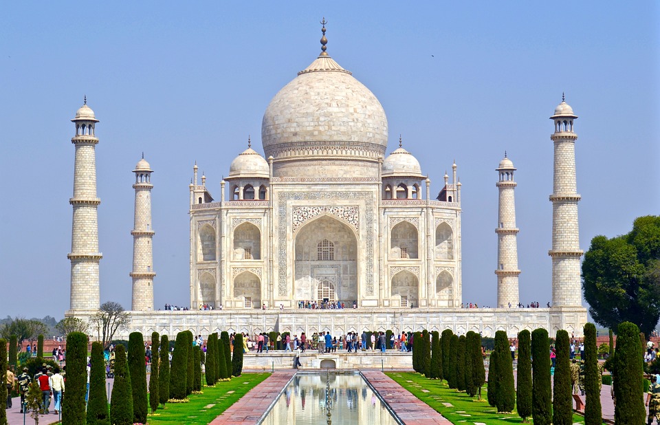
Cultural or Historical Sites of India: Important Cultural Landmarks or Historical Sites In India
Cultural or Historical Sites of India: Important Cultural Landmarks or Historical Sites In India The Taj Mahal, located in Agra, India, is one of the most iconic and recognisable landmarks in the world. Built by the Mughal emperor Shah Jahan in memory of his beloved wife Mumtaz Mahal, the Taj Mahal is a symbol of eternal love and beauty. The stunning white marble mausoleum is renowned for its intricate architectural design, including its symmetrical layout, intricate carvings, and beautiful gardens. The Taj Mahal is a masterpiece of Mughal architecture and is considered one of the most beautiful buildings in the world.Visitors to the Taj Mahal are often struck by its sheer grandeur and beauty. The main mausoleum is flanked by four minarets, each standing at over 40 meters tall, and the entire complex is set amidst lush gardens and reflecting pools. The interior of the Taj Mahal is equally impressive, with intricate marble inlay work and delicate carvings adorning the walls and ceilings. The central dome, which reaches a height of over 70 meters, is a marvel of engineering and design. As the sun sets, the white marble of the Taj Mahal takes on a warm, golden hue, adding to its ethereal beauty. The Taj Mahal is not only a testament to the enduring power of love but also a stunning example of architectural excellence. Summary The Taj Mahal is a symbol of undying love and exquisite beauty, built by Mughal Emperor Shah Jahan in memory of his beloved wife Mumtaz Mahal. The Red Fort in Delhi is a stunning example of Mughal architecture, with its intricate design and...

Natural Resources of India: Where Natural Resources are Located in India
Natural Resources of India: Where Natural Resources are Located in India India is a country rich in natural resources, which play a crucial role in its economic development and sustenance of its vast population. These resources include minerals, forests, water, energy, and agricultural land. The diverse geographical features of India have endowed it with a wide variety of natural resources, making it one of the most resource-rich countries in the world. The sustainable management of these resources is essential for the country’s future growth and development.The natural resources in India are distributed unevenly across the country, with some regions being more abundant in certain resources than others. The exploitation and management of these resources have a significant impact on the environment and the livelihoods of the people. Therefore, it is crucial to strike a balance between economic development and environmental conservation to ensure the sustainable use of these resources for future generations. Summary India is rich in natural resources, including minerals, agriculture, forests, water, and energy. The mineral resources in India include coal, iron ore, and bauxite, making it one of the leading producers of these minerals globally. Agriculture is a significant part of India’s economy, with a wide variety of crops grown across the country, including rice, wheat, and sugarcane. India’s forest resources are diverse and provide habitat for a wide range of flora and fauna, as well as valuable timber and non-timber products. Water resources in India are crucial for agriculture, industry, and domestic use, but they are under increasing pressure due to population growth and climate change. Mineral Resources in India India is rich in mineral...

Political Boundaries of India: Provinces, Districts, or Historical Boundaries.
Political Boundaries of India: Provinces, Districts, or Historical Boundaries. India, the seventh-largest country in the world, is known for its diverse culture, rich history, and complex political landscape. The political boundaries of India are a result of centuries of historical, cultural, and administrative developments. The country is bordered by Pakistan to the northwest, China and Nepal to the north, Bhutan to the northeast, and Bangladesh and Myanmar to the east. To the south, it is bounded by the Indian Ocean. India’s political boundaries are not only defined by its international borders but also by its administrative divisions, provinces, and districts. These boundaries play a crucial role in shaping the governance, economy, and society of the country.The political boundaries of India are a reflection of its diverse cultural and linguistic landscape. With over 1.3 billion people belonging to various ethnic groups and speaking different languages, India’s political boundaries have been shaped to accommodate this diversity. The country is divided into 28 states and 8 Union territories, each with its own unique identity and administrative structure. The federal structure of India’s political boundaries allows for a degree of autonomy and self-governance at the state and local levels, while also maintaining a strong central government. This complex web of political boundaries has been instrumental in managing the diverse needs and aspirations of India’s population. Summary India’s political boundaries are complex and diverse, reflecting the country’s rich history and cultural diversity. Provinces in India serve as administrative divisions, each with its own government and legislative assembly. Districts play a crucial role in local governance and jurisdiction, overseeing various aspects of public administration and...
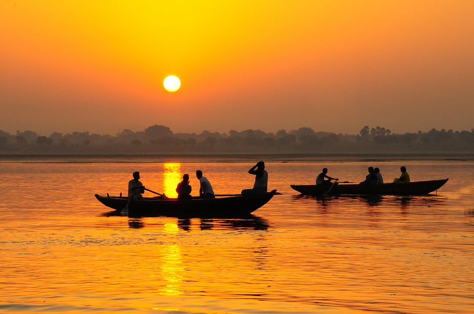
Climate Zones of India: Different climate regions Of India
Climate Zones of India: Different climate regions Of India India is a vast and diverse country with a wide range of climate zones. The country’s climate is influenced by a variety of factors, including its geographical location, topography, and the monsoon winds. As a result, India is home to several distinct climate zones, each with its own unique characteristics and weather patterns. From the tropical climate of the southern coast to the alpine climate of the Himalayas, India’s diverse climate zones make it a fascinating and varied country to explore.The different climate zones in India have a significant impact on the country’s flora, fauna, and agricultural practices. Understanding these climate zones is essential for anyone looking to visit or do business in India, as they can greatly affect travel plans, crop cultivation, and even construction practices. In this article, we will explore the various climate zones in India, from the tropical regions in the south to the alpine regions in the north, and examine the unique features and characteristics of each zone. Summary India has a diverse range of climate zones, influenced by its geography and topography. The tropical climate zones in India are characterized by high temperatures and heavy rainfall, with distinct wet and dry seasons. Subtropical climate zones in India experience hot summers and cool winters, with moderate to high rainfall throughout the year. The temperate climate zones in India have mild summers and cold winters, with moderate to high rainfall and snowfall in some areas. Alpine climate zones in India are found in the mountainous regions and have cold temperatures, heavy snowfall, and short summers. Tropical...