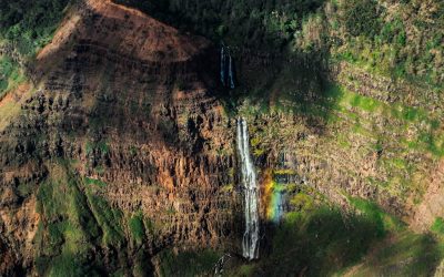
Explore the World Through Geography, Natural Resources & Daily History
Clear, reliable and engaging guides that help you understand our planet — from UK geography education to global natural resources and On This Day history events.
Explore, discover, and learn about the wonders of our world! At Earth Site, we’re passionate about bringing geography, history, and science to life for curious minds of all ages. Whether you’re delving into historical events, uncovering the mysteries of the natural world, or seeking interactive resources, you’re in the right place.
Here, you can uncover the stories behind historical events, explore the natural wonders of our planet, and gain valuable insights into how the Earth’s systems shape our daily lives. From the towering peaks of mountain ranges to the far-reaching impacts of human innovation, we aim to make every topic both engaging and informative.
Start your journey of discovery with us today, and let’s make learning an adventure!
What We Cover
Earth Site brings together engaging and accessible educational content designed to help you understand the world, its history, and its natural systems.
🌍 Geography Education (UK & Worldwide)
We publish clear, easy-to-understand geography resources for students, teachers and curious learners. Our guides support geography education in the UK and cover physical geography, climate, ecosystems, population, and global development.
⛏️ Natural Resources & Environmental Geography
Explore detailed country profiles covering natural resources, mining, energy, geology and global environmental challenges. We show how nations manage minerals, water, land and ecosystems, and why these resources matter.
📅 On This Day in History
Every day has a story. Our On This Day history series features major events, anniversaries, traditions, and cultural milestones from around the world — with timelines, context, and fun facts.
TIMELINE

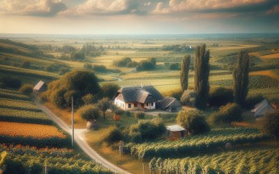
History of Moldova
Moldova’s history extends to ancient times, with archaeological evidence of human habitation in the region dating to the Palaeolithic era. Various tribes and peoples, including the Thracians, Dacians and Celts, inhabited the area. In the 4th century BC, the region came under Roman Empire control and was known as Dacia. The Romans constructed fortresses and roads in the area, leaving an enduring impact on the region’s culture and infrastructure. Following the Roman Empire’s decline, Moldova experienced invasions and settlements by various peoples, including the Huns, Goths and Slavs. In the 14th century, the principality of Moldavia emerged as a formidable state under Prince Dragos’s rule. The principality expanded its territory and became a significant regional power, engaging in trade and diplomacy with neighbouring states. The capital city of Suceava developed into a centre of culture and learning, attracting scholars and artists from across Europe. Summary Early settlements in Moldova date back to ancient times, with evidence of human habitation from as early as the Paleolithic era. Ottoman and Russian rule significantly shaped Moldova’s history, with the region being part of the Ottoman Empire and later falling under Russian control. Moldova declared independence from the Soviet Union in 1991, marking the beginning of a new era for the country. The Transnistrian conflict, which began in 1990, continues to be a major issue in Moldova, with the breakaway region seeking independence from the rest of the country. Moldova has faced challenges in recent years, including political instability and economic struggles, but has also made efforts to strengthen ties with the European Union and improve its economy. Ottoman and Russian Rule The...

Natural Resources of Moldova: Where Natural Resources are Located in Moldova
Moldova, a small landlocked country in Eastern Europe, possesses a variety of natural resources that contribute to its economy and the well-being of its citizens. From fertile agricultural land to mineral deposits and abundant water resources, Moldova‘s natural wealth plays a crucial role in the country’s development. The diverse range of natural resources in Moldova has also made it an attractive destination for investment and trade, further bolstering its economic growth. This article will explore the different natural resources that Moldova possesses, their significance, and the efforts made towards their conservation and sustainable use. Moldova’s natural resources have been a cornerstone of its economy for centuries, with agriculture being a major contributor to the country’s GDP. The fertile soil and favourable climate in Moldova make it ideal for the cultivation of a variety of crops, including grapes, fruits, vegetables, and grains. The agricultural sector not only provides food security for the population but also contributes significantly to the country’s exports, earning valuable foreign exchange. In addition to agriculture, Moldova is also rich in mineral resources such as limestone, gypsum, and clay, which are essential for the construction and manufacturing industries. The abundance of water resources, including rivers and lakes, further enhances the country’s potential for agricultural and industrial development. With its diverse natural resources, Moldova has the foundation for sustainable economic growth and development. Summary Moldova is rich in natural resources, including agricultural, mineral, water, forest, and energy resources. The agricultural sector in Moldova is a significant contributor to the country’s economy, with a focus on wine production, fruits, and vegetables. Moldova has mineral resources such as limestone, gypsum,...

Cultural or Historical Sites of Moldova: Important Cultural Landmarks or Historical Sites in Moldova
Moldova, a small landlocked country in Eastern Europe, possesses a wealth of cultural and historical sites that reflect its diverse and intriguing history. From ancient archaeological complexes to mediaeval fortresses and monasteries, Moldova‘s cultural and historical sites provide insight into the country’s past and its vibrant cultural heritage. The nation’s strategic location at the crossroads of various civilisations has left an enduring mark on its architecture, art and traditions. Visitors to Moldova can explore a wide range of cultural and historical sites that showcase the country’s unique identity and rich heritage. Moldova’s cultural and historical sites stand as a testament to the country’s resilience and enduring spirit. Despite facing numerous challenges throughout its history, Moldova has preserved its cultural treasures and continues to celebrate its heritage through these remarkable sites. Whether it is the ancient archaeological complex of Orheiul Vechi, the imposing Soroca Fortress, or the serene Capriana Monastery, each site offers a window into Moldova’s past and its enduring legacy. As visitors explore these sites, they can gain a deeper understanding of Moldova’s history, traditions and the influences that have shaped the country over the centuries. Summary Moldova is home to a rich cultural and historical heritage, with a variety of sites to explore. The Orheiul Vechi Archaeological Complex offers a glimpse into Moldova’s ancient past with its cave monastery and archaeological remains. The Soroca Fortress is a well-preserved example of medieval defensive architecture, offering visitors a chance to step back in time. The Capriana Monastery is a peaceful and picturesque site, with a history dating back to the 15th century. The National Museum of History of Moldova...

Population Density of Moldova
Moldova, a small landlocked country in Eastern Europe, is characterised by its high population density. With a population exceeding 4 million inhabitants and a land area of 33,846 square kilometres, Moldova possesses one of the highest population densities in Europe. This concentration of people within a relatively compact area presents various social, economic and environmental challenges. It is crucial to comprehend the factors contributing to this high population density, its impact on infrastructure and resources, and the efforts to manage and mitigate its effects for the sustainable development of the country. The population density of Moldova is a consequence of various historical, social and economic factors that have shaped the country’s demographic landscape. The impact of this high population density is evident in the strain it places on infrastructure and resources, as well as the challenges it poses for sustainable development. Efforts to manage and mitigate the effects of high population density in Moldova are essential for the country’s future growth and prosperity. Looking ahead, projections for Moldova’s population density indicate the need for strategic planning and policy interventions to address the challenges associated with high population density. Summary Moldova has one of the highest population densities in Europe, with over 1200 people per square mile. Factors contributing to Moldova’s high population density include high birth rates, limited emigration, and a small land area. The high population density in Moldova puts a strain on infrastructure and resources, leading to challenges in housing, transportation, and access to clean water. Compared to other European countries, Moldova’s population density is significantly higher, with only a few countries like the Netherlands and Belgium...
Moldova
Moldova (Republica Moldova (Republic of Moldova)) Capital: Chişinău Population (Estimated July 2012): 3,656,843 Area: 33,843km2 or 13,067mi2 Currency: Moldovan Leu (Plural Lei) Official Language: Moldovan Political Information: Parliamentary Republic Official Religion: No Official Religion(approximately 98% of the population are Eastern Orthodox, 1.5% are Jewish and 0.5% follow other faiths) Highest Point: Balanesti Hill at 430m or 1,411ft GDP Official Exchange Rate (OER is more precise at gauging a countries economic power) (Estimated 2011): $7.1 billion (US$) or (GBP) GDP (OER) Per Capita (per member of the population estimated 2011): (US$) or (GBP) GDP Purchasing Power Parity (PPP is good for gauging living conditions and the use of resources but not as accurate as OER. This data has been calculated based on the sum value of all goods and services produced in the country valued at prices prevailing in the United States) (Estimated 2011): $11.93 billion (US$) or (GBP) GDP (PPP) Per Capita (per member of the population estimated 2011): $3,400 (US$) or (GBP) Time Zone (GMT/UTC): -5:00 Wildlife: Counties/Provinces/States: 14 parishes; Clarendon, Hanover, Kingston, Manchester, Portland, Saint Andrew, Saint Ann, Saint Catherine, Saint Elizabeth, Saint James, Saint Mary, Saint Thomas, Trelawny, Westmorelandnote: for local government purposes, Kingston and Saint Andrew were amalgamated in 1923 into the present single corporate body known as the Kingston and Saint Andrew Corporation Leaders: H.M. Queen Elizabeth II with Governor-General Sir Patrick Allen and Prime Minister Portia Simpson-Miller Additional: Gained Independence from the UK on the 6th of August 1962. Sources: CIA World Fact Book, Encyclopaedia Britannica. Moldova Moldova is a landlocked country located in Eastern Europe, with a diverse landscape that includes rolling hills, fertile plains, and river valleys. The country is bordered by Romania to the west and Ukraine...
Political Boundaries of Micronesia: Provinces, Districts, or Historical Boundaries.
Micronesia is a region in the western Pacific Ocean, comprising thousands of small islands. It is divided into several political entities, including the Federated States of Micronesia (FSM), the Republic of the Marshall Islands, and the Republic of Palau. The region is renowned for its exceptional natural beauty, rich cultural heritage, and distinctive political landscape. Micronesia has a complex history of colonialism, with various European powers, Japan, and the United States exerting influence over different parts of the region. Today, Micronesia represents a blend of traditional island cultures and modern political systems, making it a captivating and diverse area to study. The political boundaries in Micronesia reflect its intricate history and the diverse cultures that inhabit the region. The Federated States of Micronesia comprises four states: Yap, Chuuk, Pohnpei, and Kosrae. Each state has its own government and is further divided into municipalities and districts. The Republic of the Marshall Islands and the Republic of Palau also possess their own unique political boundaries and administrative divisions. These political entities have their own governments and are responsible for managing their own affairs, whilst also maintaining relationships with each other and with external powers. The political boundaries in Micronesia play a crucial role in shaping the region’s governance, economy, and social dynamics. Summary Micronesia is a region in the western Pacific Ocean, comprising thousands of small islands. The political boundaries in Micronesia are complex, with different countries and territories having control over various islands. Micronesia is divided into four states: Yap, Chuuk, Pohnpei, and Kosrae, each with its own government and administrative structure. Within each state, there are further divisions into...
Climate Zones Of Micronesia: Different climate regions Of Micronesia
Micronesia, a region in the western Pacific Ocean, comprises thousands of small islands. The climate in Micronesia is remarkably diverse, with a range of different climate zones present across the various islands. The climate is influenced by the warm waters of the Pacific Ocean, as well as the trade winds that blow across the region. The combination of these factors results in a variety of climate zones, each with its own unique characteristics and weather patterns. From tropical rainforests to subtropical climates, Micronesia offers a wide range of environments for both residents and visitors to experience. Summary Micronesia is a diverse region with a variety of climate zones, each with its own unique characteristics and weather patterns. The Tropical Rainforest Climate in Micronesia is characterised by high temperatures, heavy rainfall, and lush vegetation, making it a haven for biodiversity. The Tropical Savanna Climate in Micronesia features a distinct wet and dry season, with grasslands and scattered trees dominating the landscape. The Tropical Monsoon Climate in Micronesia is marked by a distinct rainy season, bringing heavy rainfall and strong winds to the region. The Tropical Marine Climate in Micronesia is influenced by the surrounding ocean, resulting in warm temperatures, high humidity, and frequent rainfall. Tropical Rainforest Climate in Micronesia Characteristics of the Tropical Rainforest Climate One of the climate zones present in Micronesia is the tropical rainforest climate, characterised by high temperatures and heavy rainfall throughout the year. The islands that experience this climate zone are lush and green, with dense vegetation and a wide variety of plant and animal species. Flora and Fauna in the Tropical Rainforest The high...
History of Micronesia
Micronesia, a region in the western Pacific Ocean, has a rich history of early settlement and colonisation. The islands of Micronesia were first settled by Austronesian peoples around 1500-1000 BCE, who migrated from Southeast Asia and brought with them their unique culture and language. These early settlers were skilled navigators and seafarers, using traditional outrigger canoes to traverse the vast expanse of the Pacific Ocean. They established thriving communities on the islands, engaging in fishing, agriculture, and trade with neighbouring islands. European explorers first made contact with the islands of Micronesia in the 16th century, when Spanish navigator Ferdinand Magellan sighted the islands during his circumnavigation of the globe. Subsequent Spanish expeditions led to the colonisation of the region, with the Spanish establishing control over the islands in the late 19th century. The Spanish influence on Micronesia was profound, as they introduced Christianity, Spanish language, and European customs to the indigenous population. However, Spanish rule was short-lived, as the islands were sold to Germany in 1899 as part of the Treaty of Paris, marking the beginning of a new era of colonisation for Micronesia. The German colonial period brought significant changes to the islands, as the Germans sought to exploit the natural resources and establish plantations for copra and other cash crops. The indigenous population endured harsh labour conditions and were subjected to forced labour and cultural assimilation. Despite these challenges, the German influence on Micronesia can still be observed today in the architecture, language, and cultural practices of the region. The legacy of early settlement and colonisation continues to shape the identity and development of Micronesia to this...
Terrain and Topography of Micronesia: mountains, valleys, and plains.
Micronesia, a region in the western Pacific Ocean, comprises thousands of small islands and atolls. The terrain and topography of Micronesia are remarkably diverse, ranging from mountainous islands to low-lying atolls. The islands form part of the larger volcanic archipelago known as the Micronesian Islands, which includes the Caroline Islands, the Marshall Islands, and the Mariana Islands. The topography of Micronesia is shaped by its volcanic origins, with many of the islands having been formed by volcanic activity. The region’s terrain is characterised by rugged mountains, deep valleys, and coastal plains, making it a unique and fascinating area to explore. The diverse terrain of Micronesia results from its volcanic origins and tectonic activity. The islands are situated on the Pacific Ring of Fire, a region renowned for its high levels of seismic and volcanic activity. This has led to the formation of rugged mountain ranges, deep valleys, and coastal plains across the region. The islands are also surrounded by vast stretches of ocean, with many of them being low-lying atolls that are barely above sea level. This distinctive combination of volcanic activity and oceanic influences has created a diverse and dynamic landscape that is unlike any other in the world. Consequently, Micronesia’s terrain and topography are not only visually striking but also play a crucial role in shaping the region’s culture and society. Summary Micronesia’s terrain is diverse, with mountain ranges, valleys, lowlands, and coastal plains. The mountain ranges of Micronesia are home to unique flora and fauna, some of which are found nowhere else in the world. The valleys and lowlands of Micronesia are important for agriculture and...
Natural Resources of Micronesia: Where Natural Resources are Located in Micronesia
Micronesia, a region in the western Pacific Ocean, comprises thousands of small islands and is renowned for its abundant natural resources. The country’s natural assets include agricultural land, fisheries, mineral deposits, forests, water resources and renewable energy sources. These resources are integral to the economy and livelihoods of Micronesian citizens. The diverse natural wealth of Micronesia forms the basis for the country’s economic development and sustainability. However, proper management and conservation of these resources are essential to ensure their long-term availability and to mitigate the effects of climate change and environmental degradation. Micronesia’s natural resources are crucial for the country’s food security, economic growth and environmental sustainability. The Micronesian government acknowledges the importance of these resources and has implemented policies and programmes to manage and conserve them. Nevertheless, challenges such as climate change, overexploitation and pollution continue to threaten the sustainability of these resources. Therefore, it is imperative for Micronesia to adopt sustainable practices and conservation measures to safeguard its natural resources for future generations. This article will examine the various natural resources in Micronesia, their significance, challenges and conservation efforts. Summary Micronesia is rich in natural resources, including agriculture, fisheries, minerals, forests, water, and renewable energy sources. Agriculture and fisheries are vital to the economy of Micronesia, providing food and livelihoods for the local population. While Micronesia has limited mineral resources, there are opportunities for sustainable development and extraction of minerals. Forest resources in Micronesia are important for biodiversity, carbon sequestration, and traditional uses by local communities. Water resources in Micronesia are essential for drinking water, agriculture, and ecosystem health, but they face challenges such as pollution and...
Cultural or Historical Sites of Micronesia: Important Cultural Landmarks or Historical Sites in Micronesia
Micronesia is a region in the western Pacific Ocean, comprising thousands of small islands. It is divided into four island groups: the Caroline Islands, the Gilbert Islands, the Mariana Islands, and the Marshall Islands. The Federated States of Micronesia is a sovereign nation consisting of four states: Yap, Chuuk, Pohnpei, and Kosrae. The islands are renowned for their exceptional natural beauty, rich cultural heritage, and significant historical sites. The warm tropical climate, pristine waters, and diverse marine ecosystems make Micronesia an ideal destination for snorkelling, diving, and various aquatic activities. The islands also boast a unique and diverse culture, influenced by various indigenous groups as well as Spanish, German, Japanese, and American colonial powers. The history of Micronesia is as complex and diverse as its culture. The islands have been inhabited for millennia, with evidence of ancient civilisations found throughout the region. From prehistoric ruins to World War II historical sites, Micronesia offers a wealth of historical and cultural attractions for visitors to explore. The islands are also known for their distinctive traditional practices, such as the use of stone money on the island of Yap. With its remarkable natural landscapes and rich cultural heritage, Micronesia presents a truly unique destination that caters to a wide range of interests. Summary Micronesia is a region in the western Pacific Ocean, comprising thousands of small islands. The Nan Madol Ruins are a UNESCO World Heritage site and consist of a series of artificial islets made of basalt columns. The Lelu Ruins are the remains of an ancient city and the former capital of the island of Kosrae. The Latte Stone Sites...
Population Density of Micronesia
Micronesia is a region in the western Pacific Ocean, comprising thousands of small islands. It is divided into several island groups, including the Caroline Islands, the Marshall Islands, and the Mariana Islands. The region is renowned for its exceptional natural beauty, featuring crystal-clear waters, lush tropical forests, and diverse marine life. The people of Micronesia possess a rich cultural heritage, with distinctive traditions, languages, and customs that have been transmitted through generations. The economy of Micronesia is predominantly based on agriculture, fishing, and tourism, with an increasing emphasis on sustainable development and environmental conservation. Micronesia is a relatively small region in terms of land area, yet it is home to a diverse and vibrant population. The islands of Micronesia are inhabited by people of various ethnicities, including indigenous Micronesians, as well as migrants from other Pacific islands and countries. The population of Micronesia is distributed across numerous islands, each with its own unique characteristics and challenges. Consequently, population density varies widely across the region, with some islands being densely populated whilst others are sparsely inhabited. This diversity in population density has significant implications for the social, economic, and environmental dynamics of Micronesian society. Summary Micronesia is a region in the western Pacific Ocean, comprising thousands of small islands. Population density is the measurement of population per unit area, often expressed as people per square kilometre. Micronesia has experienced fluctuations in population density due to historical events such as colonialism and World War II. Factors affecting population density in Micronesia include limited land availability, economic opportunities, and migration patterns. High population density in Micronesia has led to challenges such as...