Explore the World Through Geography, Natural Resources & Daily History
Clear, reliable and engaging guides that help you understand our planet — from UK geography education to global natural resources and On This Day history events.
Explore, discover, and learn about the wonders of our world! At Earth Site, we’re passionate about bringing geography, history, and science to life for curious minds of all ages. Whether you’re delving into historical events, uncovering the mysteries of the natural world, or seeking interactive resources, you’re in the right place.
Here, you can uncover the stories behind historical events, explore the natural wonders of our planet, and gain valuable insights into how the Earth’s systems shape our daily lives. From the towering peaks of mountain ranges to the far-reaching impacts of human innovation, we aim to make every topic both engaging and informative.
Start your journey of discovery with us today, and let’s make learning an adventure!
What We Cover
Earth Site brings together engaging and accessible educational content designed to help you understand the world, its history, and its natural systems.
🌍 Geography Education (UK & Worldwide)
We publish clear, easy-to-understand geography resources for students, teachers and curious learners. Our guides support geography education in the UK and cover physical geography, climate, ecosystems, population, and global development.
⛏️ Natural Resources & Environmental Geography
Explore detailed country profiles covering natural resources, mining, energy, geology and global environmental challenges. We show how nations manage minerals, water, land and ecosystems, and why these resources matter.
📅 On This Day in History
Every day has a story. Our On This Day history series features major events, anniversaries, traditions, and cultural milestones from around the world — with timelines, context, and fun facts.
TIMELINE
Djibouti
Djibouti (Jumhūrīyah Jībūtī (Arabic); République de Djibouti (French) (Republic of Djibouti)) Capital: Djibouti Population (Estimated July 2012): 774,389 Area: 23,200 km2 or 8,950 mi2 Currency: Djibouti Franc (FDJ) Official Language: Arabic and French Political Information: Semi-Presidential Republic Official Religion: Islam(approximately 94% of the population are Muslim and 6% are Christian) Highest Mountain: Moussa Ali at 2,028m or 6,654ft GDP Official Exchange Rate (OER is more precise at gauging a countries economic power) (Estimated 2011): $1.3 billion (US$) or (GBP) GDP (OER) Per Capita (per member of the population estimated 2011): (US$) or (GBP) GDP Purchasing Power Parity (PPP is good for gauging living conditions and use of resources but not as accurate as OER. This data has been calculated based on the sum value of all goods and services produced in the country valued at prices prevailing in the United States) (Estimated 2011): $2.244 billion (US$) or (GBP) GDP (PPP) Per Capita (per member of the population estimated 2011): $2,600 (US$) or (GBP) Time Zone (GMT/UTC): +3:00 Wildlife: Counties/Provinces/States: 6 districts (cercles, singular – cercle); Ali Sabieh, Arta, Dikhil, Djibouti, Obock, Tadjourah Leaders: President Ismail Omar Guelleh with Dileita Mohamed Dileita as Prime Minister. Additional: Gained Independence from France on the 27th of June 1977. Sources: CIA World Fact Book, Encyclopaedia Britannica. Djibouti Djibouti, officially known as the Republic of Djibouti, is a small country located in the Horn of Africa. It is bordered by Eritrea to the north, Ethiopia to the west and southwest, and Somalia to the southeast. With a land area of approximately 23,200 square kilometres and a population of around one million people, Djibouti is one of the smallest countries in Africa. Despite...

Population Density of Djibouti
Djibouti, located in the Horn of Africa, is a small country with a population density that is among the highest in the world. With an area of just 23,200 square kilometers (8,958 square miles), Djibouti is home to approximately 1 million people, resulting in a population density of over 43 people per square kilometer (112 people per square mile). Understanding the factors that contribute to this high population density is crucial for effective planning and development in Djibouti. Summary Djibouti is a small country with a high population density. Population density is the number of people per unit of land area and can be calculated by dividing the total population by the land area. Djibouti’s small land area is a key factor in its high population density. Djibouti’s population density has shifted from nomadic to urban over time. Population density in Djibouti presents both opportunities and challenges for economic development. Understanding Population Density: Definition and Calculation Population density refers to the number of people living in a specific area, usually measured in terms of persons per square kilometer or square mile. It is calculated by dividing the total population of an area by its land area. In the case of Djibouti, the population density is calculated by dividing the country’s population of 1 million by its land area of 23,200 square kilometers. When comparing Djibouti’s population density with other countries, it becomes evident that it is significantly higher than the global average. For example, the global average population density is around 57 people per square kilometer (148 people per square mile), while Djibouti’s population density is over 43 people...

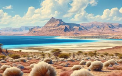
Terrain and Topography of Djibouti: mountains, valleys, and plains.
Djibouti, located in the Horn of Africa, is a small country with a diverse and unique terrain. Its geography is characterized by mountains, valleys, plains, plateaus, and coastal regions. Understanding Djibouti’s terrain and topography is crucial for various reasons, including environmental conservation, infrastructure development, and tourism. This article will provide an in-depth overview of Djibouti’s terrain and topography, highlighting the importance of preserving its unique landscape. Summary Djibouti’s terrain is diverse, with mountainous regions, valleys, plains, coastal areas, and plateaus. The mountainous regions of Djibouti are home to unique flora and fauna, including the endangered Djibouti francolin bird. The valleys of Djibouti are characterized by their steep walls and narrow floors, creating a striking landscape. The plains of Djibouti are vast and open, with sparse vegetation and a harsh climate. Volcanic activity has played a significant role in shaping Djibouti’s topography, with several active and dormant volcanoes in the region. Overview of Djibouti’s Terrain and Topography Djibouti’s landscape is a result of various geological processes that have shaped the region over millions of years. The country is located at the junction of three tectonic plates, which has contributed to its diverse topography. The terrain in Djibouti is characterized by mountains, valleys, plains, plateaus, and coastal regions. The Mountainous Regions of Djibouti Djibouti is home to several mountain ranges, including the Goda Mountains and the Mabla Mountains. These mountains are an important part of Djibouti’s ecosystem as they provide a habitat for a variety of plant and animal species. They also play a crucial role in regulating the climate by influencing wind patterns and rainfall distribution. The Valleys of Djibouti:...

Cultural or Historical Sites of Djibouti: Important Cultural Landmarks or Historical Sites in Djibouti
Djibouti, a small country located in the Horn of Africa, may not be on the top of everyone’s travel list, but it is a hidden gem waiting to be explored. With its rich cultural heritage and stunning natural wonders, Djibouti offers a unique and unforgettable experience for travelers. From ancient cities to salt lakes, from historical landmarks to ecological treasures, Djibouti has something for everyone. In this article, we will take a closer look at some of the must-visit cultural and natural wonders in Djibouti. Summary Tadjourah offers a glimpse into Djibouti’s ancient past Arta Plage combines history and natural beauty in one stunning location The Grand Mosque of Djibouti is a symbol of the country’s Islamic heritage Day Forest National Park is a must-visit for those seeking natural and cultural wonders The Afar Triangle is a geological and cultural marvel that should not be missed The ancient city of Tadjourah: A glimpse into Djibouti’s past Tadjourah, located on the Gulf of Tadjourah, is one of the oldest cities in Djibouti and offers a glimpse into the country’s past. With its narrow streets and traditional architecture, Tadjourah exudes an old-world charm that is hard to resist. The city has a rich history, having been an important trading port for centuries. It was once a major center for the slave trade and served as a hub for merchants from across the region. One of the must-see landmarks in Tadjourah is the Tadjourah Mosque, also known as the Sheikh Ahmed Dini Mosque. This beautiful mosque, built in the 19th century, is made entirely of coral stone and is a testament to...

Natural Resources of Djibouti: Where Natural Resources are Located in Djibouti
Djibouti, located in the Horn of Africa, is a small country with a diverse range of natural resources. Its geography is characterized by rugged mountains, arid deserts, and a coastline along the Red Sea and the Gulf of Aden. Despite its small size, Djibouti possesses significant natural resources that play a crucial role in its economic development. Natural resources are essential for economic growth and development as they provide the raw materials needed for various industries. Djibouti’s natural resources include minerals, petroleum and gas reserves, agriculture, fisheries, water resources, geothermal energy, and wildlife and biodiversity. These resources contribute to the country’s GDP and provide employment opportunities for its population. Summary Djibouti has a variety of natural resources including minerals, petroleum and gas reserves, agriculture, fisheries, water resources, geothermal energy, and wildlife. Djibouti’s mineral resources include gold, copper, and salt, while its petroleum and gas reserves are still being explored. Agriculture is a vital resource in Djibouti, with crops such as fruits, vegetables, and livestock providing food and income for the population. Djibouti’s fisheries are a valuable natural resource, with a variety of fish species found in the Red Sea and Gulf of Aden. Water resources in Djibouti are scarce and precious, with the country relying heavily on groundwater and desalination plants for drinking water. Mineral Resources in Djibouti: A Comprehensive Overview Djibouti is rich in mineral resources, including gold, limestone, marble, granite, gypsum, and clay. The country has been actively exploring and mining these minerals to support its construction and manufacturing industries. The mining sector in Djibouti has attracted foreign investment and has the potential for further development. Exploration...

Terrain and Topography of Denmark: mountains, valleys, and plains.
Denmark, located in Northern Europe, is a country known for its unique terrain and topography. Situated on the Jutland Peninsula and numerous islands, Denmark offers a diverse landscape that ranges from low-lying landscapes to rolling hills and coastal features. Understanding Denmark’s geography is essential for both visitors and locals, as it plays a significant role in shaping the country’s infrastructure, history, culture, and way of life. Summary Denmark’s terrain and topography are unique and diverse, with low-lying landscapes, hills, plains, islands, beaches, cliffs, dunes, rivers, lakes, glaciers, and fertile soil. The Jutland Peninsula is a mix of hills and plains, with heathlands, forests, and wetlands, and is home to Denmark’s highest point, Møllehøj. The islands of Denmark have a diverse topography, with rocky coasts, sandy beaches, rolling hills, and steep cliffs, and are popular tourist destinations. Denmark’s coastal features include long sandy beaches, high cliffs, and shifting dunes, and are shaped by wind, waves, and tides. Denmark’s waterways, including rivers and lakes, are important for transportation, fishing, and recreation, and are home to a variety of wildlife. Low-Lying Landscapes: Denmark’s Unique Geographical Features One of the defining features of Denmark’s terrain is its low-lying landscapes. The majority of the country is flat, with an average elevation of only 31 meters above sea level. This flat terrain is a result of the last ice age, which left behind vast areas of glacial deposits and created a relatively uniform landscape. The low-lying nature of Denmark’s terrain has had a significant impact on the country’s infrastructure and daily life. It has made it easier to build an extensive network of canals, rivers,...

Climate Zones Of Denmark: Different Climate Regions Of Denmark
Denmark, located in Northern Europe, is a country known for its beautiful landscapes, charming cities, and rich history. It is situated on the Jutland Peninsula and consists of over 400 islands, with a total land area of approximately 43,000 square kilometers. Due to its geographical location, Denmark experiences a variety of climate zones, each with its own unique characteristics. Understanding these climate zones is crucial for various industries and daily life in Denmark. Summary Denmark has four distinct climate zones: temperate oceanic, subarctic, continental, and Mediterranean. Western Denmark has a temperate oceanic climate with mild winters and cool summers. Northern Denmark has a subarctic climate with cold winters and mild summers. Eastern Denmark has a continental climate with cold winters and warm summers. Southern Denmark has a Mediterranean climate with mild winters and warm summers. The Temperate Oceanic Climate of Western Denmark Western Denmark is characterized by a temperate oceanic climate, which is influenced by the North Atlantic Ocean. This climate zone experiences mild summers and cool winters, with relatively high levels of precipitation throughout the year. The regions in Western Denmark that fall under this climate zone include Jutland and the western parts of Zealand. The temperate oceanic climate has a significant impact on daily life in Western Denmark. The mild summers allow for outdoor activities such as hiking, cycling, and beach visits. The cool winters bring opportunities for winter sports such as skiing and ice skating. However, the high levels of precipitation can sometimes lead to flooding and other weather-related challenges. The Subarctic Climate of Northern Denmark Northern Denmark experiences a subarctic climate, characterized by cold winters...

Political Boundaries of Denmark: Provinces, Districts, or Historical Boundaries.
Denmark, a small Scandinavian country located in Northern Europe, is known for its rich history, stunning landscapes, and vibrant culture. Understanding the political boundaries within Denmark is crucial for gaining a comprehensive understanding of the country’s governance, geography, and historical context. This article will provide an in-depth overview of the provinces and districts in Denmark, as well as explore the historical boundaries that have shaped the nation. By delving into the significance of each region, we can gain a deeper appreciation for the diverse landscapes, cultures, and contributions that make up Denmark. Summary Denmark is divided into provinces and districts, each with their own unique characteristics and history. Jutland is the largest province in Denmark, located on the mainland and known for its rugged coastline and Viking history. Zealand is the heart of Denmark, home to the capital city of Copenhagen and known for its picturesque countryside and charming towns. Funen is an island province known for its fairy tale landscapes and historic castles. South Denmark is a region of castles and beaches, while North Jutland is the northernmost province of Denmark with a unique culture and landscape. Provinces in Denmark: An Overview Denmark is divided into five provinces, also known as regions: Jutland, Zealand, Funen, North Jutland, and South Denmark. These provinces play a significant role in Danish politics and governance. Each province has its own regional council responsible for managing local affairs and implementing policies within their jurisdiction. The regional councils are elected by the residents of each province and have the power to make decisions on issues such as healthcare, education, transportation, and regional development. Understanding...

History of Denmark
Denmark, a small Scandinavian country located in Northern Europe, has a rich and fascinating history that spans over a thousand years. From its origins as a Viking society to its current status as a modern welfare state, Denmark’s past has shaped its present and will continue to influence its future. Understanding Denmark’s history is crucial for comprehending the country’s cultural, political, and social dynamics. In this article, we will explore the key events and periods that have defined Denmark’s past and examine their lasting impact. Summary Denmark’s Viking Age origins are shrouded in mystery, but evidence suggests a complex society with trade, agriculture, and warfare. The Kalmar Union united Denmark, Norway, and Sweden under one monarch, but tensions and power struggles persisted. The Reformation brought Protestantism to Denmark and led to the establishment of the Lutheran Church as the state religion. The Great Northern War saw Denmark struggle against Sweden and Russia, leading to territorial losses and economic decline. The Age of Absolutism saw the Danish monarchy consolidate power and establish a strong central government. Viking Age: The Origins of Denmark The Viking Age, which lasted from the late 8th century to the early 11th century, marks the beginning of Denmark’s recorded history. During this time, the Vikings, seafaring warriors and traders from Scandinavia, played a significant role in shaping European history. Denmark, with its strategic location between the North Sea and the Baltic Sea, became a hub for Viking expeditions and trade routes. Viking society was organized into clans or tribes led by chieftains. They were skilled sailors and warriors who raided coastal towns and monasteries across Europe,...

Population Density of Denmark
Denmark, a small Nordic country located in Northern Europe, is known for its high standard of living, strong welfare system, and progressive social policies. With a population of approximately 5.8 million people, Denmark has a relatively low population density compared to other European countries. Understanding population density is crucial for policymakers and researchers as it provides insights into the distribution of people within a given area and helps in planning for infrastructure, services, and resource allocation. Summary Denmark has a population density of 137 people per square kilometre, making it one of the most densely populated countries in Europe. Population density is calculated by dividing the total population by the land area, and is used to measure the concentration of people in a given area. Denmark’s population density has increased steadily over the past century, with the highest densities found in urban areas such as Copenhagen and Aarhus. Regional variations in population density exist across Denmark, with the western and southern regions being more densely populated than the north and east. Factors influencing population density in Denmark include urbanization, immigration, and economic opportunities, with urban areas attracting more people than rural areas. Understanding population density: definition and calculation Population density refers to the number of individuals per unit of area. It is calculated by dividing the total population of an area by its land area. For example, if a country has a population of 10 million people and an area of 100,000 square kilometers, the population density would be 100 people per square kilometer. Historical trends in Denmark’s population density Denmark’s population density has undergone significant changes over time....

Cultural or Historical Sites of Denmark: Important Cultural Landmarks or Historical Sites in Denmark
Denmark, a small Scandinavian country, holds immense cultural and historical significance. From its Viking past to its modern-day contributions to design and architecture, Denmark has a rich heritage that is worth exploring. The country is known for its picturesque landscapes, charming cities, and friendly locals. In this article, we will delve into some of Denmark’s most iconic landmarks and attractions, highlighting their historical importance and cultural significance. Exploring Denmark’s landmarks and attractions is not only a way to appreciate the country’s history but also an opportunity to immerse oneself in Danish culture. These sites offer a glimpse into the past and provide a deeper understanding of the traditions and values that have shaped Denmark into what it is today. Whether you are interested in Viking history, royal palaces, or the works of famous Danish authors, there is something for everyone in this captivating country. Summary Denmark has a rich cultural and historical significance. Tivoli Gardens is a national treasure and a must-visit attraction. The Royal Palace of Amalienborg is a symbol of Danish monarchy and history. The Viking Ship Museum is a great place to explore Denmark’s seafaring past. The Little Mermaid Statue is a cultural icon of Copenhagen and a popular tourist spot. The Iconic Tivoli Gardens: A National Treasure Tivoli Gardens, located in the heart of Copenhagen, is one of Denmark’s most beloved attractions. Founded in 1843, it is one of the oldest amusement parks in the world and holds a special place in the hearts of Danes. Tivoli Gardens is not just an amusement park; it is a cultural institution that has played a significant role...

Natural Resources of Denmark: Where Natural Resources are located in Denmark
Denmark, a small country located in Northern Europe, may not be known for its abundance of natural resources. However, it does possess a variety of resources that play a crucial role in its economy. Natural resources in Denmark include agricultural land, forests, renewable energy sources, minerals, marine resources, and water resources. These resources contribute to various sectors of the economy, such as agriculture, forestry, energy production, fishing, and water management. Despite its limited resources, Denmark has managed to utilize them efficiently and sustainably, making it a model for other countries. Summary Denmark is a small country with limited natural resources, but it has a diverse range of resources including agriculture, forests, renewable energy, minerals, fishing, and water. Agriculture is a significant contributor to Denmark’s economy and natural resources, with a focus on dairy and pork production. Denmark’s forests cover over 14% of the country and are sustainably managed, providing timber for construction and paper production. Denmark is a leader in renewable energy, with wind power accounting for over 40% of its electricity production. Denmark’s fishing industry is an important source of income and food, but faces challenges from overfishing and climate change. Denmark’s Geographical Location and Natural Resources Denmark is situated in Northern Europe and is bordered by Germany to the south. Its location has a significant impact on the availability and distribution of natural resources. The country has a land area of approximately 42,924 square kilometers and a coastline that stretches over 7,300 kilometers. This extensive coastline provides Denmark with access to marine resources and opportunities for fishing and offshore wind energy production. The Role of Agriculture in...