Explore the World Through Geography, Natural Resources & Daily History
Clear, reliable and engaging guides that help you understand our planet — from UK geography education to global natural resources and On This Day history events.
Explore, discover, and learn about the wonders of our world! At Earth Site, we’re passionate about bringing geography, history, and science to life for curious minds of all ages. Whether you’re delving into historical events, uncovering the mysteries of the natural world, or seeking interactive resources, you’re in the right place.
Here, you can uncover the stories behind historical events, explore the natural wonders of our planet, and gain valuable insights into how the Earth’s systems shape our daily lives. From the towering peaks of mountain ranges to the far-reaching impacts of human innovation, we aim to make every topic both engaging and informative.
Start your journey of discovery with us today, and let’s make learning an adventure!
What We Cover
Earth Site brings together engaging and accessible educational content designed to help you understand the world, its history, and its natural systems.
🌍 Geography Education (UK & Worldwide)
We publish clear, easy-to-understand geography resources for students, teachers and curious learners. Our guides support geography education in the UK and cover physical geography, climate, ecosystems, population, and global development.
⛏️ Natural Resources & Environmental Geography
Explore detailed country profiles covering natural resources, mining, energy, geology and global environmental challenges. We show how nations manage minerals, water, land and ecosystems, and why these resources matter.
📅 On This Day in History
Every day has a story. Our On This Day history series features major events, anniversaries, traditions, and cultural milestones from around the world — with timelines, context, and fun facts.
TIMELINE

Terrain and Topography of Panama: mountains, valleys, and plains.
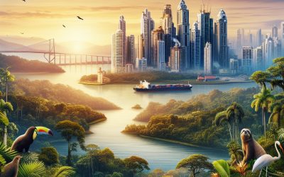
Panama, situated in Central America, is renowned for its diverse and striking terrain and topography. The nation is bordered by the Caribbean Sea to the north and the Pacific Ocean to the south, which significantly influences its landscape. Panama‘s terrain is characterised by mountain ranges, verdant valleys, plateaux, plains, and lowlands, resulting in considerable geographical diversity. The topography of Panama is also shaped by its position on the isthmus connecting North and South America, rendering it a crucial land bridge between the two continents. This unique geographical location has moulded Panama’s terrain and topography, creating a country of exceptional natural beauty and ecological importance. Panama’s terrain and topography have been instrumental in shaping the nation’s history, culture, and economy. The diverse landscape has provided a rich natural environment for human settlement and has influenced the development of infrastructure and transport networks. The varied terrain has also impacted Panama’s climate, creating distinct microclimates that support a wide range of flora and fauna. An examination of the different aspects of Panama’s terrain and topography reveals how these natural features have shaped the country’s physical and cultural landscape. Summary Panama’s terrain and topography are incredibly diverse, ranging from majestic mountain ranges to lush valleys and plateaus, as well as diverse plains and lowlands. The mountain ranges of Panama, such as the Cordillera Central and the Talamanca Range, offer breathtaking views and opportunities for outdoor activities like hiking and birdwatching. The lush valleys and plateaus of Panama, including the Chiriquí Highlands and the Azuero Peninsula, are home to rich biodiversity and fertile agricultural land. The diverse plains and lowlands of Panama, such as...

History of Panama
Panama possesses a rich history extending back to pre-Columbian times, with archaeological evidence indicating human habitation for over 11,000 years. The indigenous peoples of Panama were diverse, comprising several distinct cultures and languages. The most prominent indigenous groups in Panama were the Kuna, Emberá, Ngäbe, and Wounaan. These groups inhabited different regions of the country and maintained their own unique customs, traditions, and ways of life. The Kuna are renowned for their vibrant textiles and intricate molas, whilst the Emberá are celebrated for their exquisite handcrafted baskets and wood carvings. The indigenous peoples of Panama were adept farmers, hunters, and fishermen, possessing a profound connection to the land and the natural world. They coexisted harmoniously with nature and held a deep reverence for the environment. Their societies were frequently organised into chiefdoms or small villages, with complex social structures and religious beliefs. The arrival of the Spanish in the 16th century had a significant impact on these indigenous cultures, resulting in substantial changes to their way of life. Summary Pre-Colombian Panama was inhabited by indigenous peoples such as the Kuna, Emberá, and Ngäbe-Buglé, who had diverse cultures and societies. The Spanish conquest and colonization of Panama led to the decline of the indigenous population and the establishment of Spanish control over the region. Panama played a crucial role in the Spanish Empire as a key transit point for transporting gold and silver from South America to Spain. The construction of the Panama Canal had a significant impact on global trade and transportation, reducing travel time and costs for ships. 20th century politics in Panama were heavily influenced by the...

Population Density of Panama
Panama, a country situated in Central America, is renowned for its diverse culture, rich history and striking natural landscapes. With a population exceeding 4 million people, Panama has a population density of approximately 58 people per square kilometre. The majority of the populace is concentrated in urban areas such as Panama City, the capital and largest city in the country. The population density in Panama has been steadily increasing over the years, driven by factors such as urbanisation, migration and economic opportunities. This has resulted in both challenges and opportunities for the country, as it contends with the impact of high population density on its infrastructure, services and natural resources. Panama’s population density is influenced by a variety of factors, including its geographical features, economic opportunities and social dynamics. The country’s strategic location as a bridge between North and South America has made it a hub for international trade and commerce, attracting people from across the globe. This has led to rapid urbanisation, particularly in Panama City and its surrounding areas, where job opportunities and modern amenities are plentiful. Additionally, Panama’s diverse natural landscapes, including lush rainforests, unspoilt beaches and picturesque mountains, have also contributed to its population density, as people are drawn to the country’s natural beauty and potential for eco-tourism. However, these factors have also resulted in challenges such as overcrowding, strain on infrastructure and unequal distribution of resources. Summary Panama has a population density of 55 people per square kilometre, making it one of the most densely populated countries in Central America. Factors influencing population density in Panama include urbanisation, economic opportunities, and access to services...
Panama
Panama (República de Panamá (Republic of Panama)) Capital: Panama City Population (Estimated July 2012): 3,510,045 Area: 74,177km2 or 28,640mi2 Currency: Balboa (B) Official Language: Spanish Political Information: Presidential Republic Official Religion: No Official Religion(approximately 85% of the population are Roman Catholic and 15% are Protestant) Highest Mountain: Volcan Baru at 3,475m or 11,401ft GDP Official Exchange Rate (OER is more precise at gauging a country’s economic power) (Estimated 2011): $30.2 billion (US$) or (GBP) GDP (OER) Per Capita (per member of the population estimated 2011): (US$) or (GBP) GDP Purchasing Power Parity (PPP is good for gauging living conditions and the use of resources but is not as accurate as OER. This data has been calculated based on the sum value of all goods and services produced in the country valued at prices prevailing in the United States) (Estimated 2011): $48.76 billion (US$) or (GBP) GDP (PPP) Per Capita (per member of the population estimated 2011): $13,600 (US$) or (GBP) Time Zone (GMT/UTC): -5:00 Wildlife: Counties/Provinces/States: 9 provinces (provincias, singular – provincia) and 3 indigenous territories* (comarcas); Bocas del Toro, Chiriqui, Cocle, Colon, Darien, Embera-Wounaan*, Herrera, Kuna Yala*, Los Santos, Ngobe-Bugle*, Panama, Veraguas Leaders: President Ricardo Martinelli and Vice President Juan Carlos Varela. Additional: Gained independence from Spain on the 28th of November 1821 and Gained independence from Colombia on the 3rd of November 1903. Sources: CIA World Fact Book, Encyclopaedia Britannica. Panama Panama, officially known as the Republic of Panama, is a country situated in Central America. It shares borders with Costa Rica to the west, Colombia to the southeast, the Caribbean Sea to the north, and the Pacific Ocean to the...
Sustainable water management (irrigation, urban use)
Sustainable water management is crucial for the preservation of our planet’s most valuable resource. With the increasing global population and growing demand for water in various sectors such as agriculture, industry and urban areas, it is essential to manage water resources sustainably to ensure their availability for future generations. Sustainable water management involves the efficient use of water resources, protection of water quality and preservation of aquatic ecosystems. It also encompasses the implementation of policies and regulations to promote responsible water use and the adoption of innovative technologies to improve water efficiency. By prioritising sustainable water management, we can mitigate the impact of water scarcity, reduce pollution and safeguard the environment. One of the key reasons why sustainable water management is important is its role in addressing water scarcity. As the demand for water continues to rise, many regions around the world are facing water shortages, which can have severe consequences for communities, agriculture and ecosystems. By implementing sustainable water management practices, such as water conservation, efficient irrigation techniques and the protection of watersheds, we can alleviate the pressure on water resources and ensure their long-term availability. Additionally, sustainable water management plays a critical role in protecting aquatic ecosystems and biodiversity. By maintaining healthy water systems, we can support diverse habitats and species, as well as preserve the natural balance of ecosystems. Furthermore, sustainable water management is essential for mitigating the impact of climate change on water resources. As climate change leads to more frequent and severe droughts, floods and other extreme weather events, sustainable water management practices can help communities adapt to these challenges and build resilience against...

Political Boundaries of Palau: Provinces, Districts, or Historical Boundaries.
Palau, an island nation situated in the western Pacific Ocean, comprises a distinctive political landscape characterised by its states, municipalities, and historical demarcations. The political boundaries of Palau play a vital role in the governance and administration of the country, influencing the distribution of power and resources amongst its various regions. Comprehending the complexities of Palau’s political boundaries is crucial for understanding the country’s political structure and the dynamics that drive its governance. This article aims to provide a comprehensive examination of Palau’s political boundaries, elucidating the structure, administration, historical significance, and future prospects of these demarcations. Summary Palau’s political boundaries are defined by its system of provinces and districts, which play a crucial role in the administration and governance of the country. The provinces in Palau are structured with their own local governments, while the districts within each province serve specific functions in terms of representation and resource management. The historical boundaries of Palau have evolved over time, reflecting the country’s changing political landscape and the influence of external powers. A comparison of provinces, districts, and historical boundaries provides insight into the complexities of Palau’s political structure and the challenges it faces in maintaining cohesion and governance. Challenges and controversies surrounding Palau’s political boundaries include issues of resource allocation, representation, and the balance of power between local and national authorities, which will need to be addressed for the country’s future prospects in political governance. Provinces in Palau: Structure and Administration Palau is divided into 16 states, each of which is further subdivided into municipalities. The states, also known as provinces, are the primary administrative divisions of the country...

Climate Zones of Palau: Different climate regions Of Palau
Palau, an archipelago comprising over 500 islands in the western Pacific Ocean, is renowned for its exceptional natural beauty and diverse marine ecosystems. The climate of Palau is characterised as tropical, with consistently high temperatures and humidity throughout the year. The islands exhibit a range of climate zones, each possessing unique characteristics and exerting distinct influences on the environment. A comprehensive understanding of these climate zones is essential for the effective management of Palau’s natural resources and biodiversity. The various climate zones in Palau are influenced by factors such as ocean currents, trade winds and topography. These zones encompass tropical rainforest, tropical monsoon, tropical savanna, semi-desert and marine tropical climates. Each zone exhibits distinct patterns of temperature, precipitation and vegetation, which play a crucial role in shaping Palau’s environment and ecosystems. A detailed examination of these climate zones provides valuable insights into the environmental challenges and opportunities faced by this island nation. Summary Palau has a diverse range of climate zones, including tropical rainforest, monsoon, savanna, semi-desert, and marine tropical. The tropical rainforest climate zone in Palau is characterized by high temperatures, heavy rainfall, and lush vegetation. The tropical monsoon climate zone experiences a distinct wet and dry season, with heavy rainfall during the wet season and drier conditions during the dry season. The tropical savanna climate zone in Palau has a longer dry season and is characterized by grasslands and scattered trees. The semi-desert climate zone in Palau experiences very low rainfall and high temperatures, leading to sparse vegetation and dry landscapes. The marine tropical climate zone in Palau is influenced by the surrounding ocean, with warm temperatures...

Terrain and Topography of Palau: mountains, valleys, and plains.
Palau, an archipelago comprising over 500 islands in the western Pacific Ocean, is renowned for its remarkable natural beauty and diverse terrain. The islands form part of the larger Micronesian island group and are characterised by their rugged, mountainous landscape, verdant valleys and unspoilt beaches. The topography of Palau is the result of volcanic activity, tectonic movements and erosion over millions of years, creating a unique and varied landscape that serves as a sanctuary for nature enthusiasts and adventure seekers alike. The islands of Palau are encircled by crystal-clear waters and coral reefs, rendering them a popular destination for diving and snorkelling. The terrain of Palau is also home to a rich diversity of flora and fauna, with dense forests, mangrove swamps and unique plant species that have adapted to the challenging environment. The topography of Palau has played a significant role in shaping the culture and way of life of its people, who have relied on the land and sea for sustenance and livelihood for centuries. As such, understanding the terrain and topography of Palau is essential for appreciating the natural beauty and ecological significance of this island nation. Summary Palau’s terrain is characterized by mountain ranges, valleys, lowlands, plains, and plateaus. The mountain ranges of Palau offer stunning panoramic views and are home to diverse flora and fauna. The valleys and lowlands of Palau provide fertile land for agriculture and are important habitats for various species. The plains and plateaus of Palau are ideal for human settlement and agricultural activities. The unique terrain of Palau has a significant impact on its rich biodiversity and is crucial for...

Natural Resources of Palau: Where Natural Resources are located In Palau
Palau, an archipelago comprising over 500 islands in the western Pacific Ocean, is renowned for its stunning natural beauty and rich biodiversity. The country’s natural resources are diverse and abundant, ranging from marine and terrestrial ecosystems to mineral deposits and renewable energy sources. These resources play a crucial role in supporting the livelihoods of the local population, as well as driving the country’s economy through tourism, fishing, agriculture and sustainable energy production. Palau‘s natural resources are not only valuable for their economic significance but also for their cultural and ecological importance, making their conservation and sustainable management a top priority for the government and local communities. The unique geographical location of Palau, surrounded by pristine waters and lush tropical forests, has endowed the country with a wealth of natural resources that have sustained its people for generations. The delicate balance of these ecosystems is essential for the survival of numerous plant and animal species, some of which are endemic to the region. As such, the preservation of Palau’s natural resources is not only a matter of economic interest but also a moral obligation to protect the environment for future generations. In this article, we shall explore the various natural resources found in Palau, their significance and the efforts being made to conserve and manage them sustainably. Summary Palau is rich in natural resources, including marine, terrestrial, mineral, and renewable energy resources. The marine resources in Palau are diverse and abundant, including a wide variety of fish, coral reefs, and other marine life. Palau’s terrestrial resources include lush forests, diverse plant and animal species, and fertile soil for agriculture. While...

Cultural or Historical Sites of Palau: Important Cultural Landmarks or Historical Sites In Palau
Palau, an archipelago comprising over 500 islands in the western Pacific Ocean, boasts a wealth of cultural and historical sites. The rich history and diverse cultural heritage of the Palauan people are evident in the ancient stone monoliths, traditional meeting houses and sacred waterfalls scattered across the landscape. Japanese World War II relics serve as a sobering reminder of the island’s turbulent past. The Belau National Museum stands as a repository of Palauan culture, preserving and exhibiting the traditions and customs of the indigenous people. The Rock Islands, a UNESCO World Heritage Site, showcase the natural beauty and ecological importance of the region. Each of these sites contributes to the tapestry of Palau’s cultural and historical legacy. Palau’s cultural and historical sites are not only a testament to the island’s past but also serve as a source of pride and identity for the Palauan people. These sites continue to shape the cultural landscape of the archipelago. Visitors to Palau have the opportunity to experience the traditions and customs of the indigenous people, gaining insight into the island’s rich heritage. From the ancient stone monoliths that stand as silent sentinels to the traditional meeting houses that once served as communal gathering spaces, each site offers a glimpse into the essence of Palau. An exploration of the cultural and historical sites of Palau reveals a world steeped in tradition, folklore and resilience, where the past intertwines with the present to create a vibrant tapestry of heritage. Summary Palau is home to a rich cultural and historical heritage, with a variety of sites that showcase its unique traditions and history. The ancient...

History of Palau
Palau, an archipelago comprising over 500 islands in the western Pacific Ocean, possesses a rich history spanning thousands of years. The earliest known inhabitants of Palau are thought to have arrived circa 1000 BCE, with archaeological evidence of their presence found in the form of ancient pottery and stone implements. These early settlers were adept seafarers and fishermen who established a sophisticated society with a hierarchical social structure and system of governance. European contact with the islands of Palau first occurred in the 18th century, when British and American vessels explored the region. However, formal European control was not established until the 19th century. In 1885, Spain asserted sovereignty over the islands, maintaining control until the Spanish-American War of 1898. Following this conflict, governance of Palau was transferred to Germany as stipulated in the Treaty of Paris. This period of European colonisation brought about significant changes to Palauan culture and society, as the islands were introduced to new technologies, religions and political systems. Summary Early Settlement and Colonization: Palau was settled over 3,000 years ago by migrants from the Philippines and Indonesia. The first European to sight the islands was the Spanish explorer Ruy López de Villalobos in 1543. Spanish and German Rule: The Spanish claimed Palau in 1885, but sold it to Germany in 1899. Under German rule, Palau experienced significant economic and social changes. Japanese Occupation: Palau was occupied by Japan from 1914 to 1944. The Japanese built extensive military installations on the islands during this time. World War II and the Battle of Peleliu: The Battle of Peleliu in 1944 was one of the bloodiest battles...

Population Density of Palau
Palau, officially the Republic of Palau, is an island nation situated in the western Pacific Ocean. It forms part of the broader Micronesian island group and comprises more than 340 islands, with Koror and Babeldaob being the most populous. The country is renowned for its exceptional natural beauty, featuring unspoilt beaches, dense forests and thriving coral reefs. Palau boasts a rich cultural heritage, placing significant emphasis on traditional customs such as oral storytelling, indigenous dance and artisanal craftsmanship. The nation’s economy relies heavily on tourism, fisheries and agriculture, with an increasing focus on sustainable development and environmental preservation. Summary Palau is an island country in the western Pacific Ocean, known for its stunning natural beauty and rich cultural heritage. Factors affecting population density in Palau include limited habitable land, economic opportunities, and access to basic services. The majority of the population in Palau is concentrated in the capital city of Ngerulmud and the largest town of Koror. Urban population in Palau is increasing due to better job opportunities and access to amenities, while rural areas are experiencing a decline in population. High population density in Palau has put pressure on infrastructure, leading to challenges in providing adequate housing, transportation, and healthcare facilities. Factors Affecting Population Density Several factors contribute to the population density of Palau. Firstly, the limited land area of the islands restricts the amount of space available for habitation. This leads to higher population density in urban areas, particularly in the capital city of Koror. Additionally, the natural resources and climate of Palau play a role in population distribution. The fertile soil and tropical climate make certain...