Explore the World Through Geography, Natural Resources & Daily History
Clear, reliable and engaging guides that help you understand our planet — from UK geography education to global natural resources and On This Day history events.
Explore, discover, and learn about the wonders of our world! At Earth Site, we’re passionate about bringing geography, history, and science to life for curious minds of all ages. Whether you’re delving into historical events, uncovering the mysteries of the natural world, or seeking interactive resources, you’re in the right place.
Here, you can uncover the stories behind historical events, explore the natural wonders of our planet, and gain valuable insights into how the Earth’s systems shape our daily lives. From the towering peaks of mountain ranges to the far-reaching impacts of human innovation, we aim to make every topic both engaging and informative.
Start your journey of discovery with us today, and let’s make learning an adventure!
What We Cover
Earth Site brings together engaging and accessible educational content designed to help you understand the world, its history, and its natural systems.
🌍 Geography Education (UK & Worldwide)
We publish clear, easy-to-understand geography resources for students, teachers and curious learners. Our guides support geography education in the UK and cover physical geography, climate, ecosystems, population, and global development.
⛏️ Natural Resources & Environmental Geography
Explore detailed country profiles covering natural resources, mining, energy, geology and global environmental challenges. We show how nations manage minerals, water, land and ecosystems, and why these resources matter.
📅 On This Day in History
Every day has a story. Our On This Day history series features major events, anniversaries, traditions, and cultural milestones from around the world — with timelines, context, and fun facts.
TIMELINE

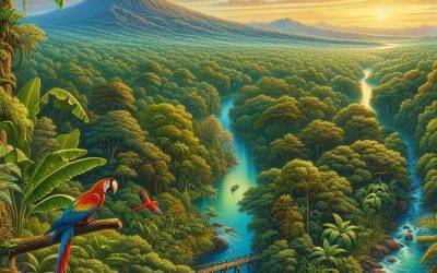
Population Density of Costa Rica
Costa Rica, a small country located in Central America, is known for its rich biodiversity and stunning natural landscapes. Despite its small size, Costa Rica has a relatively high population density compared to other countries in the region. Population density refers to the number of people living in a specific area, usually measured in square kilometers or square miles. In the case of Costa Rica, its population density is around 97 people per square kilometer. The significance of population density lies in its impact on various aspects of a country’s development and sustainability. A high population density can put pressure on resources such as land, water, and infrastructure. It can also affect the quality of life for individuals living in densely populated areas, as overcrowding can lead to issues such as traffic congestion, pollution, and limited access to public services. Understanding the population density of Costa Rica is crucial for policymakers and urban planners to make informed decisions about resource allocation and sustainable development. Summary Costa Rica has a population density of 97 people per square kilometer, making it one of the most densely populated countries in Central America. The country’s geographical features, including its mountain ranges and coastal plains, have a significant impact on population distribution. The majority of Costa Rica’s population is concentrated in the Central Valley region, which includes the capital city of San Jose. Urbanization has led to significant population growth in Costa Rica’s cities, with over 60% of the population now living in urban areas. Despite the trend towards urbanization, rural areas still play an important role in Costa Rica’s economy and culture. The...
Costa Rica
Costa Rica (República de Costa Rica (Republic of Costa Rica)) Capital: San José Population (Estimated July 2012): 4,636,348 Area: 51,100 km2 or 19,730 mi2 Currency: Costa Rican Colón (₡) Official Language: Spanish Political Information: Constitutional Democracy Official Religion: Roman Catholicism (approximately 76.3% of the population are Roman Catholic, 13.7% are Evangelical, 1.3% are Jehovas Witnesses, 4.5% have other religious beliefs and 3.2% have no religious beliefs) Highest Mountain: Cerro Chirripo at 3,810m or 12,500ft GDP Official Exchange Rate (OER is more precise at gauging a countries economic power) (Estimated 2011): $40 billion (US$) or (GBP) GDP (OER) Per Capita (per member of the population estimated 2011): (US$) or (GBP) GDP Purchasing Power Parity (PPP is good for gauging living conditions and use of resources but not as accurate as OER. This data has been calculated based on the sum value of all goods and services produced in the country valued at prices prevailing in the United States) (Estimated 2011): $54.47 billion (US$) or (GBP) GDP (PPP) Per Capita (per member of the population estimated 2011): $11,500 (US$) or (GBP) Time Zone (GMT/UTC): -6:00 Wildlife: Counties/Provinces/States: provinces (provincias, singular – provincia); Alajuela, Cartago, Guanacaste, Heredia, Limon, Puntarenas, San Jose Leaders: Laura Chinchilla is the current President of Costa Rica with Alfio Piva as 1st Vice President and Luis Liberman as 2nd Vice President. Sources: CIA World Fact Book, Encyclopaedia Britannica. Costa Rica Costa Rica, located in Central America, is a small country known for its stunning natural beauty and biodiversity. Bordered by Nicaragua to the north and Panama to the south, Costa Rica is a land of lush rainforests, towering volcanoes, and pristine beaches. With a population of around...

Political Boundaries of the Republic of the Congo Brazzaville: Provinces, Districts, or Historical Boundaries.
The Republic of the Congo Brazzaville, commonly referred to as Congo-Brazzaville, is a country located in Central Africa. It is bordered by Gabon to the west, Cameroon and the Central African Republic to the north, the Democratic Republic of the Congo to the east, and Angola and the Atlantic Ocean to the south. With an area of approximately 342,000 square kilometers, it is one of the smaller countries in Africa. Understanding the political boundaries of Congo-Brazzaville is crucial for various reasons, including governance, administration, and resource management. Summary The Republic of the Congo Brazzaville is divided into 12 administrative departments. The provinces of the Republic of the Congo Brazzaville are further divided into districts and communes. The political boundaries of the Republic of the Congo Brazzaville were established during the colonial era. Districts play an important role in the political boundaries of the Republic of the Congo Brazzaville. Colonialism had a significant impact on the political boundaries of the Republic of the Congo Brazzaville. Understanding the Administrative Divisions of the Republic of the Congo Brazzaville Congo-Brazzaville is divided into administrative divisions known as departments. There are a total of 12 departments in the country, each headed by a prefect. The central government in Brazzaville has authority over these departments and is responsible for their governance and administration. However, there are also local authorities within each department that play a significant role in decision-making and implementation of policies at the local level. The central government in Brazzaville is responsible for national policies, legislation, and overall governance of the country. It has authority over key sectors such as defense, foreign affairs,...

Climate Zones Of Republic of the Congo Brazzaville: Different climate regions Of Republic of the Congo Brazzaville
The Republic of the Congo Brazzaville, also known as Congo-Brazzaville, is a country located in Central Africa. It is bordered by Gabon, Cameroon, the Central African Republic, the Democratic Republic of the Congo, and Angola. The country has a diverse climate due to its geographical location and topography. Understanding the different climate zones in the Republic of the Congo Brazzaville is crucial for various reasons, including agriculture, economic development, and environmental conservation. Summary Republic of the Congo Brazzaville has a diverse range of climate zones, including equatorial, tropical savanna, humid subtropical, semi-arid, arid, coastal, and mountain. The equatorial climate zone is characterized by high temperatures, heavy rainfall, and high humidity, making it ideal for rainforest vegetation. The tropical savanna climate zone has distinct wet and dry seasons, with grasslands and scattered trees dominating the landscape. The humid subtropical climate zone experiences mild winters and hot summers, with abundant rainfall and fertile soils. The semi-arid climate zone has low rainfall and high temperatures, with vegetation adapted to drought conditions. The impact of these climate zones on agriculture and the economy is significant, with crops and livestock varying depending on the region. Climate change is expected to have a significant impact on the climate zones of Republic of the Congo Brazzaville, with potential changes in rainfall patterns and temperatures affecting agriculture and the economy. Equatorial Climate Zone The equatorial climate zone is characterized by high temperatures and heavy rainfall throughout the year. This climate zone is found in the northern part of the Republic of the Congo Brazzaville, including areas such as Likouala and Cuvette. The equatorial rainforest is one of...

Terrain and Topography of the Republic of the Congo Brazzaville: mountains, valleys, and plains.
The Republic of Congo Brazzaville, also known as Congo-Brazzaville, is a country located in Central Africa. It is bordered by Gabon to the west, Cameroon and the Central African Republic to the north, the Democratic Republic of the Congo to the east, and Angola and the Atlantic Ocean to the south. The country is known for its diverse terrain and topography, which play a crucial role in shaping its landscape and influencing various aspects of its economy and biodiversity. Understanding the terrain and topography of the Republic of Congo Brazzaville is essential for several reasons. Firstly, it helps in understanding the country’s natural resources and their distribution. Secondly, it provides insights into the different ecosystems present in the country and their importance for biodiversity conservation. Lastly, it helps in identifying potential economic activities that can be developed in different regions based on their geographical characteristics. Summary The Republic of Congo Brazzaville has a diverse terrain and topography. The Congo Basin has a significant impact on the country’s landscape. The coastal plains are crucial to the country’s economy. The Congo River plays a significant role in the country’s topography. The northern highlands are a region of mountains and plateaus. The Congo Basin and Its Impact on the Country’s Landscape The Congo Basin is one of the largest tropical rainforest areas in the world, covering a significant portion of Central Africa, including parts of the Republic of Congo Brazzaville. It is characterized by dense vegetation, numerous rivers, and a diverse range of wildlife. The basin has a significant impact on the country’s landscape as it covers a large part of its...

Natural Resources of Republic of the Congo Brazzaville: Where Natural Resources are located In Republic of the Congo Brazzaville
The Republic of the Congo Brazzaville, also known as Congo-Brazzaville, is a country located in Central Africa. It is bordered by Gabon, Cameroon, the Central African Republic, the Democratic Republic of the Congo, and the Atlantic Ocean. The country is known for its rich natural resources, which play a crucial role in its economy. Congo-Brazzaville is blessed with a diverse range of natural resources, including minerals, forests, oil and gas reserves, agricultural land, wildlife, and water resources. These resources have been instrumental in driving economic growth and development in the country. They have attracted foreign investment and generated revenue through exports, contributing significantly to the country’s GDP. Summary Republic of the Congo Brazzaville is rich in natural resources, including minerals, forests, oil and gas, agriculture, wildlife, fisheries, and water resources. The country has significant mineral deposits, including iron ore, copper, gold, and diamonds, which have the potential to drive economic growth. The abundant forests of Republic of the Congo Brazzaville are home to a diverse range of plant and animal species, and provide important ecosystem services such as carbon sequestration and water regulation. The country’s vast oil and gas reserves are a major source of revenue, but also pose environmental and social challenges that need to be addressed. Republic of the Congo Brazzaville has significant agricultural potential, with fertile soils and a favourable climate, but needs to invest in infrastructure and technology to fully realize this potential. The Rich Mineral Deposits of Republic of the Congo Brazzaville Congo-Brazzaville is home to vast mineral deposits, including iron ore, copper, gold, diamonds, and potash. The mining sector has been a major...

History of the Republic of the Congo Brazzaville
Congo Brazzaville, officially known as the Republic of Congo, is a country located in Central Africa. It has a rich and complex history that has shaped its present-day society and politics. Understanding the country’s past is crucial for comprehending its current challenges and opportunities. This article will provide a comprehensive overview of Congo Brazzaville’s history, from its early settlement and colonization to its independence and subsequent political developments. Summary Congo Brazzaville was first settled by Bantu-speaking tribes over 2,000 years ago. French colonization in the late 19th century led to the exploitation of natural resources and the emergence of Congolese nationalism. Independence in 1960 was followed by political instability, including the Congo Crisis and the rise of Marxist-Leninist ideology. The Sassou-Nguesso era saw political repression and civil war, leading to the formation of the Republic of Congo in 1992. The country’s economy is heavily reliant on oil exports, but efforts are being made to diversify and improve relations with neighboring countries and the international community. Early Settlement and Colonization of Congo Brazzaville The history of Congo Brazzaville dates back to the arrival of Portuguese explorers in the late 15th century. They were followed by other European powers, including the French, who established colonial rule in the late 19th century. The French presence had a profound impact on the local populations, as they imposed their language, culture, and administrative systems on the Congolese people. French Rule and the Emergence of Nationalism Under French rule, Congolese nationalism began to emerge in the early 20th century. The Congolese people started to form political parties and organizations to advocate for their rights and...

Cultural or Historical Sites of Republic of the Congo Brazzaville: Important Cultural Landmarks or Historical Sites in Republic of the Congo Brazzaville
Congo Brazzaville, officially known as the Republic of the Congo, is a country located in Central Africa. It is often overshadowed by its larger neighbor, the Democratic Republic of the Congo, but it is a country rich in history and culture. Exploring the cultural and historical landmarks of Congo Brazzaville is not only a way to learn about the country’s past, but also to appreciate its vibrant present. Summary The National Museum of Congo Brazzaville houses a vast collection of cultural artifacts. Brazzaville Cathedral is a stunning example of colonial architecture. The Presidential Palace is a symbol of Congo Brazzaville’s political history. The Pierre Savorgnan de Brazza Memorial honors the founder of Brazzaville. The Congo River is a vital waterway for trade and transport. The National Museum of Congo Brazzaville: A Treasure Trove of Cultural Artifacts The National Museum of Congo Brazzaville is a must-visit for anyone interested in the country’s rich cultural heritage. The museum houses a vast collection of artifacts that showcase the diverse history and traditions of Congo Brazzaville. From ancient pottery and sculptures to traditional masks and musical instruments, the museum offers a comprehensive look into the country’s cultural heritage. One of the highlights of the museum is its collection of traditional Congolese art. Visitors can admire intricate wood carvings, vibrant textiles, and beautiful beadwork that reflect the artistic traditions of different ethnic groups in Congo Brazzaville. The museum also has a section dedicated to contemporary Congolese art, showcasing the works of local artists who are pushing boundaries and exploring new artistic expressions. Brazzaville Cathedral: A Stunning Example of Colonial Architecture Brazzaville Cathedral, also known...

Population Density of Republic of the Congo Brazzaville
The Republic of the Congo Brazzaville, also known as Congo-Brazzaville, is a country located in Central Africa. It is bordered by Gabon to the west, Cameroon and the Central African Republic to the north, the Democratic Republic of the Congo to the east, and Angola and the Atlantic Ocean to the south. The country has a rich history and culture, with influences from various ethnic groups such as the Kongo, Teke, and Mbochi. Geographically, the Republic of the Congo Brazzaville is characterized by dense rainforests, savannahs, and rivers. The capital city, Brazzaville, is situated on the banks of the Congo River. The country has a population of approximately 5 million people, with a diverse mix of ethnicities and languages spoken. Understanding population density is crucial in the context of the Republic of the Congo Brazzaville due to its impact on various aspects of development and planning. Population density refers to the number of people living in a specific area, usually measured in terms of persons per square kilometer. By understanding population density, policymakers and planners can make informed decisions regarding resource allocation, infrastructure development, and social services provision. Summary The Republic of the Congo Brazzaville is a country located in Central Africa. Population density is the number of people living in a specific area and is important for resource allocation and planning. Factors affecting population density in the Republic of the Congo Brazzaville include urbanization, migration, and natural disasters. Population distribution is uneven, with higher densities in urban areas and lower densities in rural areas. There are regional differences in population density, with the highest densities in the capital...

Republic of the Congo Brazzaville
Republic of the Congo Brazzaville (République du Congo (Republic of the Congo)) Capital: Brazzaville Population (Estimated July 2012): 4,366,266 Area: 342,000 km2 or 132,047 mi2 Currency: CFA franc (CFAF) Official Language: French Political Information: Presidential Republic Official Religion: No Official Religion (approximately 50% of the population are Christian, 48% are Animist and 2% are Muslim) Highest Mountain: Mount Berongou at 903m or 2,963ft GDP Official Exchange Rate (OER is more precise at gauging a country’s economic power) (Estimated 2011): $15.1 billion (US$) or (GBP) GDP (OER) Per Capita (per member of the population estimated 2011): (US$) or (GBP) GDP Purchasing Power Parity (PPP is good for gauging living conditions and the use of resources but is not as accurate as OER. This data has been calculated based on the sum value of all goods and services produced in the country valued at prices prevailing in the United States) (Estimated 2011): $18.36 billion (US$) or (GBP) GDP (PPP) Per Capita (per member of the population estimated 2011): $4,600 (US$) or (GBP) Time Zone (GMT/UTC): +1:00 Wildlife: Counties/Provinces/States: 10 regions (regions, singular – region) and 1 commune*; Bouenza, Brazzaville*, Cuvette, Cuvette-Ouest, Kouilou, Lekoumou, Likouala, Niari, Plateaux, Pool, Sangha Leaders: President is Denis Sassou Nguesso Additional: Gained Independence from France on the 15th of August 1960. Sources: CIA World Fact Book, Encyclopaedia Britannica. Congo Brazzaville Congo Brazzaville, officially known as the Republic of the Congo, is a country located in Central Africa. It is bordered by Gabon to the west, Cameroon and the Central African Republic to the north, the Democratic Republic of the Congo to the east, and Angola and the Atlantic Ocean to the south. With a population...

Terrain and Topography of Democratic Republic of the Congo: mountains, valleys, and plains.
The Democratic Republic of Congo (DRC) is a country located in Central Africa, known for its vast and diverse terrain. From towering mountains to expansive plains, the DRC’s landscape plays a crucial role in the country’s development. Understanding the topography of the DRC is essential for various sectors, including agriculture, mining, transportation, and disaster preparedness. By examining the different regions of the DRC and the challenges they present, we can gain a deeper understanding of the country’s potential and the need for sustainable development practices. Summary The Democratic Republic of Congo has a diverse terrain and topography, including mountains, valleys, plains, and the Congo River Basin. The mountainous regions of the DRC are home to active volcanoes and have a significant impact on the country’s landscape. The valleys of the DRC are important agricultural areas and are home to many of the country’s rivers. The plains of the DRC are vast and largely undeveloped, but have potential for future agricultural and industrial development. The Congo River Basin is a vital part of the DRC’s topography, providing water and resources for millions of people. The Mountainous Regions of the DRC: A Closer Look The DRC is home to several major mountain ranges, including the Rwenzori Mountains, Virunga Mountains, and Mitumba Mountains. These mountainous regions are not only breathtakingly beautiful but also hold significant importance for the country’s development. The fertile slopes of these mountains provide ideal conditions for agriculture, with crops such as coffee, tea, and potatoes thriving in these high-altitude areas. Additionally, these regions are rich in mineral resources, including gold, tin, and coltan, making them valuable for mining...

History of Democratic Republic of the Congo
The Democratic Republic of the Congo, often referred to as Congo, is a country located in Central Africa. It is the second-largest country in Africa by land area and is rich in natural resources such as diamonds, gold, copper, and cobalt. However, the history of Congo is marred by colonization, exploitation, and conflict. In order to understand the present-day challenges and opportunities facing the country, it is crucial to delve into its complex history. Summary The Congo people have a rich pre-colonial history that dates back centuries. Belgian colonial rule was marked by the exploitation of Congo’s vast natural resources and the brutal treatment of its people. Patrice Lumumba led the fight for independence, but his government was overthrown in a coup and he was assassinated. The Mobutu era was characterized by dictatorship and corruption, which left the country in economic ruin. The First and Second Congo Wars were complex conflicts involving regional and international actors, resulting in millions of deaths and displacement. Joseph Kabila’s rise to power marked a transition to a democratic republic, but his rule was also marked by controversy and allegations of corruption. The 2006 elections were the first free and fair elections in 40 years, but the country still faced challenges in establishing a stable democracy. The UN peacekeeping mission played a crucial role in stabilizing the country’s fragile peace. The 2018 elections were controversial, with allegations of fraud and irregularities, raising questions about the future of Congo’s democracy. Congo’s history has left the country with many challenges, but also opportunities for growth and development. The Pre-Colonial Era: The Origins of the Congo People...